

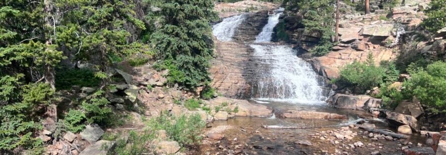
Not every stop on Mirror Lake Highway needs to be a summit. Upper Provo River Falls is a half-mile out-and-back that puts you at a cascading series of waterfalls in a pine and aspen canyon, takes about 30 minutes, and can anchor a full Uintas day or work as a standalone stop when the schedule is tight. It’s 25 miles east of Kamas on UT-150 and directly off the highway with its own parking area. You park, you walk, you get a genuine mountain waterfall. I stop here when I’m running the Mirror Lake Highway corridor and want something that delivers immediately without the investment of a full hike. Moving water creates a sensory shift in a mountain canyon, the sound changes everything around it. Upper Provo River Falls does that in a short distance. It’s worth the stop every time I drive past it.
Quick Facts
| Trail Name | Upper Provo River Falls Trail |
| Location | Uinta-Wasatch-Cache National Forest, near Kamas, Utah |
| Coordinates | 40.6574° N, 110.9454° W |
| Distance | 0.5 miles roundtrip |
| Elevation Gain | Less than 50 feet |
| Difficulty | Easy |
| Time | 30-60 minutes |
| Dogs Allowed | Yes, on leash |
| Fee | Mirror Lake Highway pass: $10 (1-3 day) or $20 (7-day); America the Beautiful Pass accepted |
| AllTrails | View on AllTrails |
How to Get There
From Kamas, take Mirror Lake Highway (UT-150) east for approximately 25 miles. Signs for Upper Provo River Falls are posted on the right side of the road. The parking area is directly off the highway. You can’t miss it if you’re watching for the signs. From Salt Lake City, take I-80 east to US-40 east toward Heber City, then exit toward UT-248 east to Kamas. From Kamas, turn east onto Mirror Lake Highway and drive 25 miles. Total time from Salt Lake City is about 1.5 hours. From Park City, Kamas is about 20 minutes south on UT-32. Mirror Lake Highway closes November 1st and typically reopens around Memorial Day weekend depending on snowpack. Upper Provo River Falls is inaccessible during the winter months. Check USFS road status before planning a late spring visit in June, as the road sometimes opens later after heavy snow years.
Parking Information
The designated parking area for Upper Provo River Falls is directly off Mirror Lake Highway. It’s smaller than the Mirror Lake area lots and fills quickly on summer weekends and holiday weekends. Early mornings and weekday visits give you the best chance at an easy pull-in. If the main lot is full, roadside parking in designated pull-off areas is an option but avoid blocking the highway or parking on soft shoulder areas. A Mirror Lake Highway pass is required: $10 for a 1-3 day pass or $20 for a 7-day pass. America the Beautiful Annual Pass is accepted and covers the fee. Pay at self-serve kiosks positioned along the highway before reaching the falls. 
Cell Service and Navigation
Cell coverage on Mirror Lake Highway degrades as you gain elevation from Kamas and is spotty or absent at the Upper Provo River Falls parking area. Download AllTrails offline before leaving town. For a half-mile trail this direct, navigation isn’t the issue, but having offline maps is a good habit for any Mirror Lake Highway stop and useful if you’re continuing to other destinations in the corridor.
What to Expect at Upper Provo River Falls
The Trail
The trail from the parking area to the falls viewpoints is short, well-maintained, and accessible to essentially any ambulatory visitor. The path runs through pine and aspen forest with the sound of the Provo River audible before you can see the falls. Viewing platforms at several points along the short trail give different perspectives on the cascade as it drops down a rocky gorge. The falls are a series of cascades rather than a single dramatic drop. The Provo River picks up speed and volume through a narrow rocky channel, producing a layered waterfall effect that changes character depending on where you’re standing relative to it. Snowmelt in late May and June produces the highest and most dramatic flow. By late summer, the volume drops but the setting remains beautiful.
Photography
The falls are in a canyon that filters direct sunlight at most times of day, making them more consistently photogenic than exposed waterfall locations. Overcast days produce even, soft light with no harsh shadows across the falling water. Sunny days work best in morning or late afternoon when the sun angles into the canyon rather than overhead. A slower shutter speed blurs the water into the classic silky waterfall effect. The viewing platforms provide stable footing for handheld shooting but a tripod or gorilla pod is worth having for the longer exposures needed to fully blur the cascade. Polarizing filter cuts the glare off the wet rocks and deepens the greens in the surrounding forest.
Trail Difficulty and Length
Easy is accurate. The 0.5-mile roundtrip has negligible elevation change and the viewing platforms make the destination fully accessible without any scrambling. This is appropriate for all ages and fitness levels, including young children, older adults, and anyone who wants a genuine natural feature experience without a hike commitment. Budget 30-60 minutes including time at the viewing platforms. The falls reward some patience: spending 10-15 minutes at each platform rather than a quick glance and retreat delivers a more complete experience of the cascade and gives the light time to shift.
Dog Friendly?
Yes. Upper Provo River Falls is on National Forest land and dogs are welcome on leash. The short trail and easy terrain make this one of the more dog-friendly stops on the Mirror Lake Highway corridor. Keep dogs leashed at all times and away from the creek bank and viewing platform edges. The water at the base of the falls can look inviting but the current is strong. Do not let dogs wade into the falls area. Bring water for dogs. The high elevation and pine forest environment in summer can be warm enough that even short stops require hydration for active dogs. 
What to Bring
Water, even for a 30-minute stop. Mirror Lake Highway sits above 8,000 feet and the dry mountain air dehydrates faster than you expect. Sun protection for the walk from the parking area. Layers for the canyon sections where the temperature drops relative to the parking lot. For photography: a tripod or equivalent for slow shutter waterfall work, a polarizing filter, and a wide-angle lens for the cascade full-frame. A rain jacket or camera cover if there’s any chance of afternoon showers, since the canyon keeps things wet.
Best Time to Visit Upper Provo River Falls
Late May through June is the peak water flow window, when snowmelt from the surrounding mountains feeds the Provo River at its highest volume. The falls are most dramatic at this time of year. This is also when the Mirror Lake Highway freshly reopens and the canyon vegetation is at its most vibrant green. The Mirror Lake Highway closes November 1st. Plan your last fall visit for late October at the latest, knowing early snowstorms can close the road before the official date.
Rules and Regulations
Stay on designated trails and viewing platforms. The vegetation and soil around the falls are fragile and erode easily with foot traffic off the established path. Do not swim in the pools at the base of the falls. The current is strong and the water is cold year-round; the USFS posts signage at the site about swimming restrictions. Pack out all trash. Dogs on leash at all times. America the Beautiful Pass or Mirror Lake Highway day pass required. Leave No Trace principles apply.
Where to Stay Near Kamas
Kamas is 25 miles west on Mirror Lake Highway, about 30-35 minutes from the falls parking area. It has basic services but limited lodging. Park City, 20 minutes south of Kamas on UT-32, has full resort town infrastructure. For points travelers, check available Marriott Bonvoy properties, IHG Rewards hotels, and Hilton Honors options in Park City and Salt Lake.
Camping Nearby
The Mirror Lake Highway has multiple developed campgrounds. Mirror Lake Campground is the main established option, with tent and RV sites and facilities, operated by the Uinta-Wasatch-Cache National Forest. Reservations through recreation.gov during peak season. Sites book fast for summer weekends. Dispersed camping is permitted on National Forest land outside campground boundaries throughout the Uintas corridor. Standard rules apply: 200 feet from water sources, pack in pack out, 14-day stay limit. Upper Provo River Falls itself is not a designated camping area.
Nearby Adventures
Bald Mountain Trail is the step-up option from the same Mirror Lake Highway corridor. At 2.8 miles roundtrip to an 11,943-foot summit, it’s the longer commitment that pairs naturally with an Upper Provo River Falls stop on the same day. The falls in the morning, the summit in the late morning, Mirror Lake in the afternoon makes a full Uintas day without overcommitting. Mirror Lake Loop is the easy alternative: a flat walk around Mirror Lake with fishing access and mountain views, accessible from the Mirror Lake Highway a few miles past the falls. The Provo River below Kamas offers fly fishing, kayaking, and tubing on the lower river sections in summer. The river changes character dramatically from the alpine cascade at the falls to the wider, slower-moving sections in the valley below Kamas. Park City’s Main Street has a full restaurant and bar scene, mountain biking on resort lift-accessed trails in summer, and the outlet mall complex at the I-80 junction for anyone who needs gear or souvenirs. It’s the full-service base for Mirror Lake Highway exploration.
Plan This Stop
AllTrails has Upper Provo River Falls mapped with offline capability and recent visitor notes. Download before leaving Kamas since signal drops on the highway. Plan your visit on AllTrails and pull the offline map while you’ve got signal in town.
Chase the Quiet
The falls are loud in late May and early June when the snowmelt is at full force, loud enough to hear from the parking area before you reach the viewing platforms. That’s the version I prefer: the Provo River running at full capacity through a canyon that echoes the sound back from both walls. It’s easy to get to. It’s free with the highway pass. And it sounds like exactly what a mountain canyon with a waterfall should sound like. Not everything worth seeking out requires significant effort. Some things just require turning off the highway and walking for 15 minutes.
Support the Adventure
To make your walls less boring, check out my photography portfolio and bring a piece of the wild and my story into your home. If you’d like to fuel future adventures, you can donate a coffee on Ko-Fi. Every cup keeps me chasing sunrises and stories. When you shop using my affiliate links, every click helps support this blog at no extra cost to you. It’s a small way to keep Unicorn Adventure alive and kicking while I keep exploring. Subscribe to my mailing list for future updates, new stories, and behind-the-scenes adventures. Stay connected with me on Instagram and Facebook for more photos and daily inspiration.

Theo Maynard is a landscape photographer and adventure blogger based in Salt Lake City. He chases remote desert and mountain light across the American West, documents it all solo, and shares the journey through Unicorn Adventure. He’s on the autism spectrum, and that’s not a footnote, it’s the whole story. He creates to inspire others to get outside, chase what lights them up, and live their best possible life. Unapologetically himself.