

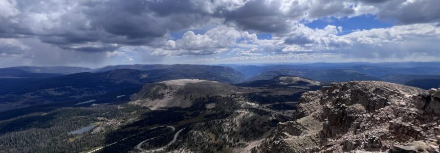
The Uinta Mountains are the only major mountain range in the contiguous United States that runs east-west rather than north-south, and Bald Mountain sits near the western end of that range at 11,943 feet, accessible from the Mirror Lake Highway about 30 miles east of Kamas. The trail to the summit is short enough to complete in half a morning and just steep enough to make the summit feel earned. At the top, the 360-degree view takes in the alpine lake country of the Uintas in every direction, with Mirror Lake, Moosehorn Lake, and several other unnamed lakes visible below and the ridgelines of the High Uintas extending east to the horizon. I’ve driven Mirror Lake Highway more than once and hiked Bald Mountain as part of Uintas days that include multiple stops. It’s the kind of summit that delivers disproportionate reward for the effort: a small investment of time and elevation gain returning a genuinely high summit perspective. I evaluate trails on that ratio specifically, and Bald Mountain scores well. The summit is as good as any of the larger efforts in the range. This guide covers the Bald Mountain Trail from the pass trailhead to the summit: verified stats, what the route involves, the Mirror Lake Highway access window, and how to build a full Uintas day around it.
Quick Facts
| Trail Name | Bald Mountain Trail |
| Location | Uinta-Wasatch-Cache National Forest, near Kamas, Utah |
| Coordinates | 40.6892° N, 110.9040° W (Bald Mountain Pass Trailhead) |
| Distance | 2.8 miles roundtrip (trailhead to summit and back) |
| Elevation Gain | ~1,200 feet |
| Difficulty | Moderate |
| Time | 2-3 hours |
| Dogs Allowed | Yes, on leash |
| Fee | America the Beautiful Pass or day use fee; self-serve kiosks on Mirror Lake Highway |
| AllTrails | View on AllTrails |
How to Get There
From Kamas, Utah, take Highway 150 (Mirror Lake Highway) east into the Uinta-Wasatch-Cache National Forest. Follow the highway for approximately 30 miles, climbing from the valley floor through evergreen forest and into alpine terrain. The Bald Mountain Pass trailhead is on the left side of the road at the highest point of the Mirror Lake Highway, clearly signed. From Salt Lake City, plan about 1.5 hours: I-80 east to US-40 east to Heber City, then north on US-189 to Kamas, then east on Highway 150. From Park City, Kamas is about 20 minutes south on UT-32. The Mirror Lake Highway drive is worth going slowly regardless of where you’re coming from: it’s one of the better alpine highway drives in Utah. Critical seasonal note: the Mirror Lake Highway closes November 1st and typically reopens around Memorial Day weekend, depending on snowpack. The Bald Mountain Trailhead is inaccessible outside this window. Check the USFS website for current road status before planning a trip in June or late September. Even after the road opens, the summit can hold snow into July some years.
Parking Information
The Bald Mountain Pass parking area is directly off the Mirror Lake Highway at the trailhead. It’s a reasonable size but fills on summer weekends, particularly on Saturdays. Arrive before 9 a.m. on weekends to secure a spot. The lot has no restroom facilities. Handle that in Kamas before driving in or at one of the facilities at Mirror Lake Campground, a few miles back on the highway. A recreation fee applies to the Mirror Lake Highway corridor. Self-serve pay kiosks are positioned at several points on the highway. The America the Beautiful Annual Pass covers the fee. Pay before you park at the Bald Mountain Trailhead. 
Cell Service and Navigation
Cell coverage is spotty on the Mirror Lake Highway and effectively absent at Bald Mountain Pass and on the summit. Download AllTrails offline before leaving Kamas or Salt Lake City. The trail is well-marked and the route is straightforward, but having GPS active is useful on the exposed upper sections where the trail crosses open rock and the route can be less obvious.
What to Expect on the Bald Mountain Trail
The Trail
The trail starts at Bald Mountain Pass, already at around 10,700 feet, and climbs 1,200 feet to the 11,943-foot summit. The starting elevation means altitude is a factor from the first steps, particularly for hikers coming from Salt Lake City’s 4,300 feet or lower. The lower section moves through sub-alpine terrain with patches of conifer and open rocky ground. The vegetation quickly thins as the trail gains the exposed ridge. The upper sections are open talus and scree with the trail marked by cairns and worn rock. Footing requires attention on the loose sections. The summit ridge is exposed on both sides and the wind can be significant even on clear summer days. A mid-layer and a wind shell are worth having in the pack regardless of the morning forecast temperature at the trailhead.
The Summit
The 11,943-foot summit of Bald Mountain delivers the 360-degree view the name and the effort promise. Mirror Lake is visible directly below to the west. Moosehorn Lake and Reid’s Peak Lake sit in the basin to the north and east. The High Uintas ridgeline extends east with multiple 13,000-foot peaks visible on clear days, including Kings Peak, the highest point in Utah at 13,534 feet. The Great Basin flats are visible to the west on clear days. The summit is wind-exposed and can get cold fast even in summer. Sit out of the wind if there’s a rock formation offering shelter. For photography, the morning window puts the sun behind you looking east toward the High Uintas ridgeline and illuminates the alpine lakes in the basin below from above. Late afternoon creates better light on Mirror Lake for shots looking west from the summit. 
Trail Difficulty and Length
Moderate is accurate for this route. Two routes exist to Bald Mountain in the Uintas: the standard pass trailhead route at approximately 2.8 miles roundtrip (covered here) and a longer ‘Bald Mountain via Silver Lake Trail’ at 4.0 miles / 1,266 feet. The difficulty comes from the high starting elevation and the exposed talus on the upper sections. Fit hikers from sea level who aren’t acclimatized will feel the oxygen deficit on the upper push. Plan 2-3 hours for the round trip at a comfortable pace with time on the summit. The trail is short enough to complete in a half-day and pair with other Uintas stops.
Dog Friendly?
Yes. Bald Mountain Trail is on National Forest land and dogs are welcome on leash. The talus sections on the upper trail require dogs that are comfortable and confident on uneven rocky terrain. Assess your dog’s ability honestly: smaller or less nimble dogs may struggle on the loose rock above the treeline. The lower sections of the trail are accessible for most dogs. No water sources on the trail from trailhead to summit. Bring at least a liter of water for dogs in addition to your own supply. The summit wind can accelerate dehydration for both humans and dogs faster than the short duration of the hike suggests.
What to Bring
Water: 2 liters per person minimum, more if you’re doing additional Uintas stops after. No water on the trail. The high elevation and exposed terrain dehydrate faster than equivalent effort at lower altitude. A mid-layer and wind shell for the summit. Sun protection for the fully exposed upper sections. Sturdy hiking boots or trail runners with grip for the talus. For photography: wide-angle for the summit panorama and the alpine lake views below, mid-range for the distant ridgeline detail. The summit view is wide enough that a single frame won’t capture all of it; plan for panoramic stitching or accept the editorial choice of a direction.
Best Time to Hike Bald Mountain
The Mirror Lake Highway closes November 1st. Plan your last visit for late September or early October, knowing that early fall snowstorms can close the road before the official date.
Rules and Regulations
Stay on the designated trail to protect fragile alpine vegetation. The talus sections are open rock where trail adherence isn’t always defined, but avoid stepping on soil or plant material between boulders. The Uinta alpine ecosystem is fragile and recovers slowly from foot traffic damage. America the Beautiful Pass or recreation fee required for the Mirror Lake Highway corridor. Pay at self-serve kiosks before parking at the trailhead. Dogs on leash. Pack out all trash. No fires above tree line. Leave No Trace principles apply throughout.
Where to Stay Near Kamas
Kamas is the nearest town, about 30 miles west of the Bald Mountain Trailhead on the Mirror Lake Highway. It has basic services but limited lodging. Park City, about 20 minutes from Kamas, has full resort town infrastructure with lodging at every price point. For points travelers, check available Marriott Bonvoy properties, IHG Rewards hotels, and Hilton Honors options in Park City and Salt Lake.
Camping Nearby
The Mirror Lake Highway corridor has multiple developed campgrounds operated by the Uinta-Wasatch-Cache National Forest. Mirror Lake Campground is the most established, directly on the highway near Mirror Lake, with tent and RV sites and facilities. Reservations through recreation.gov during peak season. Sites fill fast for summer weekends. Dispersed camping is permitted on Forest Service land outside designated campground boundaries in the Uintas. Standard rules apply: 200 feet from water sources, pack in pack out, 14-day stay limit. The Uintas offer some of the best dispersed camping in Utah for anyone willing to drive a few miles off the highway on dirt roads.
Nearby Adventures
Mirror Lake Loop is the obvious companion stop from the same highway corridor. It’s an easy trail around Mirror Lake with fishing access, wildlife viewing, and the mountain backdrop. Low effort, high scenery payoff. The broader High Uintas Wilderness offers the Highline Trail, one of the premier long-distance backpacking routes in Utah, running roughly 68 miles along the crest of the range. Day hikers can access sections of it from multiple trailheads on and near the Mirror Lake Highway. Additional area destinations include Cataract Gorge Trail, Soapstone Cliffs / Lightning Ridge, and Joan Lake / Gem Lake / Echo Lake Trail. Park City is the nearest full-service destination for anyone doing the Uintas as a multi-day trip. Mountain biking, ski resort summer operations, and the downtown Main Street restaurant and bar scene round out a complete Utah mountain town experience. 
Plan This Hike
AllTrails has Bald Mountain Trail mapped with offline capability and condition reports from recent hikers. Particularly useful for timing your visit relative to snowmelt and current summit conditions in June or after early fall storms. Plan your hike on AllTrails and pull the offline map before you lose signal on the Mirror Lake Highway.
Chase the Quiet
The Uintas run east-west when every other major range in the region runs north-south, and from the summit of Bald Mountain that geometric stubbornness is readable in the landscape. The ridgelines go the wrong direction and they’re beautiful for it. Mirror Lake sits in the basin below like a mirror that’s been left out in the open. The High Uintas ridgeline extends east toward Kings Peak and the Utah sky is big enough to hold all of it. That’s the summit of an 11,943-foot peak accessible from the highway in a half-morning. Nevada doesn’t get all the secrets.
Support the Adventure
To make your walls less boring, check out my photography portfolio and bring a piece of the wild and my story into your home. If you’d like to fuel future adventures, you can donate a coffee on Ko-Fi. Every cup keeps me chasing sunrises and stories. When you shop using my affiliate links, every click helps support this blog at no extra cost to you. It’s a small way to keep Unicorn Adventure alive and kicking while I keep exploring. Subscribe to my mailing list for future updates, new stories, and behind-the-scenes adventures. Stay connected with me on Instagram and Facebook for more photos and daily inspiration. Thanks for being part of the journey, Unicorn Squadron!

Theo Maynard is a landscape photographer and adventure blogger based in Salt Lake City. He chases remote desert and mountain light across the American West, documents it all solo, and shares the journey through Unicorn Adventure. He’s on the autism spectrum, and that’s not a footnote, it’s the whole story. He creates to inspire others to get outside, chase what lights them up, and live their best possible life. Unapologetically himself.