

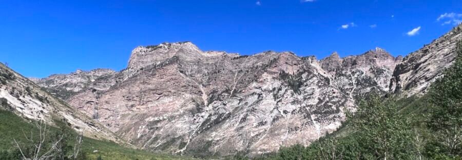
Thomas Creek Trail takes a different approach to the Ruby Mountains than the Lamoille Canyon routes. Instead of sharing a trailhead at the end of a scenic byway with half a dozen other hikers, you turn off NV-227 onto Thomas Creek Road before the canyon, drive a rougher gravel road, and arrive at a trailhead that sees a fraction of the traffic the Lamoille Canyon parking area does on a summer weekend. The trail follows Thomas Creek upstream through aspen forest and meadow terrain for 4.5 miles roundtrip, gaining 1,200 feet to the upper canyon with mountain views that reward the quieter approach. I’ve come to appreciate trails that give you the Ruby Mountains without the weekend crowd math that Lamoille can require. Thomas Creek runs cooler on that front. The creek itself sets the tone: you hear it before you see it, and it follows you the whole way in. That consistent sound is its own kind of anchor. This guide covers Thomas Creek Trail from the end of Thomas Creek Road to the upper canyon: how to get there on a gravel road that requires some attention, what the terrain actually involves, and how to build a day around it from Elko.
Quick Facts
| Trail Name | Thomas Creek Trail |
| Location | Thomas Canyon, Ruby Mountains, Elko, Nevada |
| Coordinates | 40.6502° N, 115.4060° W |
| Distance | 4.5 miles roundtrip |
| Elevation Gain | ~1,200 feet |
| Difficulty | Moderate |
| Time | 3–5 hours |
| Dogs Allowed | Yes, on leash |
| Fee | None (National Forest land) |
| AllTrails | View on AllTrails |
How to Get There
From Elko, head south on NV-227 for approximately 12 miles. Watch for the signed Thomas Creek Road turnoff on the left before you reach Lamoille. Thomas Creek Road is a maintained gravel road, but it’s rougher than Lamoille Canyon Road and benefits from higher clearance, especially after wet weather. Follow Thomas Creek Road to the end at the trailhead parking area. The drive on Thomas Creek Road passes ranch land and transitions into canyon terrain as you gain elevation toward the trailhead. It’s a different approach aesthetic than the dramatic Lamoille Canyon Scenic Byway, quieter and more utilitarian, but the trailhead environment is peaceful and the creek is audible from the parking area. From Salt Lake City, Elko is about 3 hours west on I-80. From Reno, roughly 5 hours east. The Thomas Creek trailhead is about 20 miles and 30 minutes from downtown Elko. No entry fee, no permit required for day hiking.
Parking Information
The trailhead parking area at the end of Thomas Creek Road is spacious and free. It sees significantly less traffic than the Lamoille Canyon end-of-road lot, which makes weekend visits more manageable. No restrooms and no facilities at the trailhead. Plan accordingly before leaving Elko. A high-clearance vehicle is recommended for Thomas Creek Road, particularly in the final stretch approaching the trailhead. Most capable SUVs handle it in dry conditions. After rain, the road can become muddy and rutted. Check conditions if there’s been recent precipitation. 
Cell Service and Navigation
Cell coverage drops on NV-227 south of Elko and is minimal on Thomas Creek Road and at the trailhead. Download AllTrails or another navigation app offline before leaving Elko. The trail follows Thomas Creek upstream and is generally well-marked, but the upper sections transition to more open terrain where cairns space out. Having GPS active on the upper portion is useful for maintaining your position and confirming the turnaround point if you’re aiming for a specific elevation rather than a lake or summit.
What to Expect on the Thomas Creek Trail
The trail starts at the parking area and enters the creek canyon almost immediately. Thomas Creek runs on or near the trail for most of the lower section, providing the ambient sound of moving water that defines the experience of this route. The lower canyon is shaded by aspen and conifer forest, and the tree cover holds moisture that keeps the trail noticeably cooler than the exposed terrain above. The path climbs steadily along the creek, crossing it at a couple of points where stepping stones or a simple ford are required depending on water levels. In spring and early summer, the creek runs higher and the crossings require more attention. By late summer, they’re typically easy. Waterproof boots or shoes you’re comfortable getting wet are a smart choice for early-season visits. Above the forested lower section, the terrain opens into meadow country with the Ruby Mountain peaks visible on both sides of the canyon. Wildflowers dominate the meadow sections through July and early August. The creek continues beside the trail but the character shifts from forest canyon to open mountain valley. The upper section of the trail becomes more rocky and the grade steepens slightly before the trail’s end or your chosen turnaround point. The views from the upper canyon look back down the creek drainage toward the desert basin below Elko, with the Ruby Mountain ridgeline framing the upper canyon in both directions. It’s not a summit view, but it’s a full mountain perspective that rewards the elevation gain. 
Trail Difficulty and Length
Moderate is accurate. The 4.5-mile roundtrip with 1,200 feet of gain is in the middle range of the Ruby Mountains day hike options, harder than Island Lake in terms of gain-to-distance ratio, easier than Liberty Lake in total commitment. The creek crossings in spring add a variable difficulty element that disappears by late summer. Plan 3-5 hours for the round trip at a comfortable pace. The trailhead sits around 6,800 feet elevation, lower than the Lamoille Canyon trailhead, which makes acclimatization less of a factor than on the higher-elevation routes. Trail runners work on the lower section; hiking boots with grip are better for the rocky upper terrain and the creek crossings.
Dog Friendly?
Yes. Thomas Creek Trail is on National Forest land and dogs are welcome on leash. The creek along the lower section is a natural draw for dogs, providing water access throughout the hike rather than only at the destination. Keep dogs leashed and away from the creek banks immediately around water sources where trail erosion is already occurring. Bring extra water for dogs beyond what the creek provides. Mountain creek water is generally clean but always carries giardia risk. Dogs that drink directly from moving mountain streams typically manage fine, but if your dog has a sensitive system, bring filtered or bottled water. Pack out waste throughout. The trail’s lower traffic volume is worth maintaining. 
What to Bring
Water from Elko: 2-3 liters per person. A filter or purification tablets if you want to supplement from the creek. The creek provides water throughout the lower section, but don’t count on it as your primary source. Layers. The trailhead is at a lower elevation than Lamoille Canyon, so morning temperatures are less extreme, but the upper canyon can be windy and the Ruby Mountains build afternoon thunderstorms quickly in July and August. A rain shell is worth carrying. Waterproof hiking boots or trail runners for the creek crossings. Sun protection for the open upper meadow sections.
Best Time to Hike Thomas Creek Trail
Late May through September is the reliable window. The Thomas Creek trailhead sits at a lower elevation than the Lamoille Canyon routes, which means the trail is snow-free earlier in the season, often by late May in most years. This makes Thomas Creek a good early-season option when the Lamoille Canyon trails are still carrying snow on the upper sections. June is the wildflower peak in the meadow sections and the creek runs at its fullest. The crossings are the most variable this time of year. July brings the highest temperatures but the lower trailhead elevation means the heat is less extreme than on the Lamoille Canyon routes. Afternoon thunderstorms build in July and August; start early. September is the best overall month. Fall color arrives in the aspen groves in the lower canyon by mid-month and the trail is quiet. The creek drops to its lowest levels, making crossings trivial. The meadow upper section has good late-season light with the lower sun angle creating texture on the mountain walls above. For photography, morning works best for the lower canyon where the aspen groves are lit from the east. The upper meadow sections open up to good mid-morning light before the overhead glare flattens the terrain. Fall is the premium photography window for the aspen color in the lower canyon, typically peaking around the third week of September.
Rules and Regulations
No campfires in the area. Pack a stove if cooking. Pack out all trash and dog waste. Stay on the trail to protect the fragile alpine meadow vegetation in the upper section and the creek bank vegetation throughout. The creek crossings should be made at established crossing points rather than new locations. Creating new crossing spots widens the disturbed area and accelerates bank erosion. If the established crossing point is flooded and unsafe in spring, assess whether to turn around rather than creating a new ford location.
Where to Stay Near Elko
Elko is the base, about 20 miles and 30 minutes from the Thomas Creek trailhead. The town has solid lodging and serves as a natural overnight stop on the I-80 corridor.
Camping Nearby
Thomas Canyon Campground in Lamoille Canyon is the closest developed campground to the Ruby Mountains trails, operated by Humboldt-Toiyabe National Forest. It runs from late May through September with tent and RV sites, and reservations are available through recreation.gov during peak season. Dispersed camping on National Forest land is permitted in some areas outside the Wilderness boundary. Check current regulations with the Ruby Mountains Ranger District in Spring Creek, Nevada, before planning an overnight trip. No camping at the Thomas Creek trailhead itself.
Nearby Adventures
The Lamoille Canyon routes offer the bigger alpine lake destinations from the Ruby Mountains. Liberty Lake Trail is 6 miles roundtrip with 1,500 feet of gain and ends at a granite cirque lake. Island Lake Trail is 3.5 miles roundtrip with 900 feet of gain to a smaller, more enclosed alpine lake. Both trails depart from the end of Lamoille Canyon Road, a separate approach from Thomas Creek Road. The Ruby Crest Trail traverses the range crest for roughly 40 miles from south to north. Day hikers can access sections of the crest from multiple trailheads in the Ruby Mountains. The full traverse is one of Nevada’s best multi-day backpacking routes. The Lamoille Canyon Scenic Byway itself is worth a slow drive as a separate activity. The canyon road passes picnic areas, interpretive stops, and several short nature trails before reaching the end-of-road Lamoille Canyon parking area. It’s accessible to any vehicle and works as an evening scenic drive from Elko even without a hiking objective. In Elko: the Northeastern Nevada Museum covers local history and wildlife. The Western Folklife Center documents Great Basin cowboy and ranching culture. The Star Hotel is the most distinctive dining option in town, rooted in Elko’s Basque heritage since the early 1900s.
Plan This Hike
AllTrails has Thomas Creek Trail mapped with offline capability and condition reports from recent hikers. Download before you lose signal on NV-227. The trail condition reports are useful for checking creek levels in early season. Plan your hike on AllTrails and pull the offline map while you’ve still got signal in Elko.
Chase the Quiet
Thomas Creek Trail has what the Lamoille Canyon routes don’t: a version of the Ruby Mountains that runs on lower pressure. The creek is there the whole time, which anchors the hike in a different way than a trail that’s just climbing toward a destination. You move through the sound of the water changing as the canyon opens and closes around it. The aspens in the lower section filter the light differently at every hour. And at the top, the mountain views arrive without the crowd that the more famous routes collect on weekend mornings. That’s a fair trade.
Support the Adventure
To make your walls less boring, check out my photography portfolio and bring a piece of the wild and my story into your home. If you’d like to fuel future adventures, you can donate a coffee on Ko-Fi. Every cup keeps me chasing sunrises and stories. When you shop using my affiliate links, every click helps support this blog at no extra cost to you. It’s a small way to keep Unicorn Adventure alive and kicking while I keep exploring. Subscribe to my mailing list for future updates, new stories, and behind-the-scenes adventures. Stay connected with me on Instagram and Facebook for more photos and daily inspiration. Thanks for being part of the journey, Unicorn Squadron!

Theo Maynard is a landscape photographer and adventure blogger based in Salt Lake City. He chases remote desert and mountain light across the American West, documents it all solo, and shares the journey through Unicorn Adventure. He’s on the autism spectrum, and that’s not a footnote, it’s the whole story. He creates to inspire others to get outside, chase what lights them up, and live their best possible life. Unapologetically himself.