The 20 Lakes Trail Loop doesn’t have a maintained trail for its entire length. That’s the point. After the first two miles from the Crystal Lake Trailhead, the route requires map reading and GPS use to navigate between the lakes in the basin, and that act of navigation is part of what makes it a different experience from a standard marked trail. The named lakes on this route include Crystal, Watson, Clyde, and Hidden Wall Lake, among others in the basin. The name promises twenty and the basin delivers a landscape where you can find them if you know where you’re going. I’ve done loop routes in the Uintas that require route-finding and they change the relationship you have with the terrain. When you’re following a trail, you’re moving through a landscape. When you’re navigating, you’re reading one. The High Uintas basin above the Crystal Lake Trailhead is exactly the right terrain for that: open alpine ground, multiple lake basins visible from ridges above, and enough distinctive features to landmark your position without constant GPS checking. I have a particular appreciation for spatial problem-solving. This trail delivers it. This guide covers the 20 Lakes Trail Loop: confirmed stats, what the route-finding situation actually involves, and how to prepare for a hike where the map is not optional.
Quick Facts
| Trail Name | 20 Lakes Trail Loop (Crystal, Watson, Clyde, Hidden Wall Lake) |
| Location | Uinta-Wasatch-Cache National Forest / High Uintas Wilderness, near Kamas, Utah |
| Coordinates | 40.6814° N, 110.9628° W (Crystal Lake Trailhead) |
| Distance | 7.6 miles (loop) |
| Elevation Gain | ~1,000 feet |
| Difficulty | Moderate with route-finding (download map before going) |
| Time | 5-7 hours |
| Dogs Allowed | Yes, on leash |
| Fee | Mirror Lake Highway pass: $10 (1-3 day) or $20 (7-day); America the Beautiful Pass accepted |
| AllTrails | View on AllTrails |
How to Get There
From Kamas, take Mirror Lake Highway (UT-150) east for approximately 30 miles. Watch for the signed Crystal Lake Trailhead on the right side of the highway. The trailhead is well-marked and easy to identify from the road. From Salt Lake City, take I-80 east to US-40 east toward Heber City, then exit toward UT-248 east to Kamas. From Kamas, head east on Mirror Lake Highway for 30 miles. Total time from Salt Lake is approximately 1.5-1.75 hours. From Park City, Kamas is about 20 minutes south on UT-32. Mirror Lake Highway closes November 1st and reopens around Memorial Day weekend depending on snowpack. Check USFS road status before planning a visit in June. Snow can persist in the higher basins on this route into early July in heavy snow years, affecting route-finding conditions on the upper sections.
Parking Information
The Crystal Lake Trailhead has a large, well-maintained parking lot with restrooms and information kiosks. It serves multiple trails including the 20 Lakes Loop, so it can fill on summer weekends, particularly on Saturdays. Arrive before 8 a.m. on weekends during peak season. The Mirror Lake Highway pass is required: $10 for a 1-3 day pass or $20 for 7 days. The America the Beautiful Annual Pass covers the fee. Self-serve pay kiosks are positioned along the highway before the Crystal Lake Trailhead. 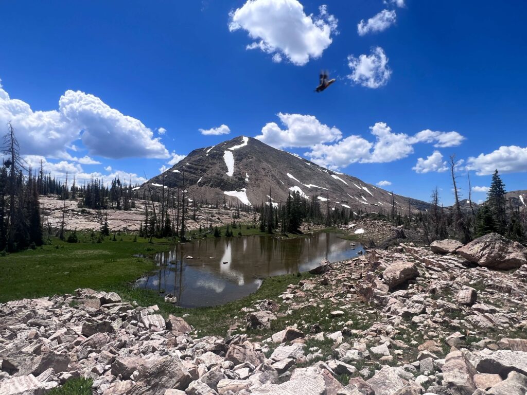
Cell Service and Navigation
This section matters more for this trail than for any other in the Uintas catalog. Cell coverage is absent on the Mirror Lake Highway above the valley floor and completely absent at the Crystal Lake Trailhead and on the route. Download your map before you leave Kamas. This is not optional. The route-finding on the 20 Lakes Loop begins after about 2 miles of marked trail. From there, you’re navigating to lakes using terrain features, GPS coordinates, and whatever downloaded map you have. AllTrails has the route mapped and the GPS track is the most valuable feature here. A dedicated handheld GPS unit is a reasonable investment for a loop of this character if you do route-finding hikes regularly. Bring a printed backup map as well. A downloaded map on a phone with a dead battery is no map at all. Know your battery situation before you start and bring a backup power source.
What to Expect on the 20 Lakes Trail Loop
The Marked Section: Crystal Lake Area
The first two miles from the Crystal Lake Trailhead follow a maintained trail through pine forest and open alpine terrain toward Crystal Lake. This section is straightforward and well-marked. Crystal Lake is the named anchor of the route and one of the larger water bodies in the basin. The trail through this section passes other smaller lakes and gives you a preview of the lake-dense terrain that characterizes the rest of the loop.
The Route-Finding Section
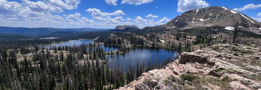
Past the marked trail section, the loop transitions to route-finding across open alpine terrain. The High Uintas basin above the trailhead is a landscape of granite, sub-alpine meadows, shallow lake basins, and connecting streams. You navigate between lakes using GPS coordinates and terrain features: ridgelines, drainage patterns, and the distinctive shapes of the rock outcroppings above each lake. Watson Lake, Clyde Lake, and Hidden Wall Lake are among the named destinations on this route. Each basin has its own character: some are enclosed, some more open, some have dramatic cliff walls above the water. The route moves between them via the path of least resistance through the alpine terrain, which requires judgment about which slopes and ridges to cross and which drainage channels to follow. If at any point the terrain doesn’t match your mental model of where you are on the map, stop. Check your GPS. Reorient before moving. Getting turned around in an off-trail alpine basin on a cloudy day is a real way to extend your day significantly. The basin is navigable, but it requires active engagement with the map throughout.
The Lakes
The number of lakes depends on how you define the route and how far you deviate from the main loop to visit smaller ponds in the basin. The name 20 Lakes is an approximation of the density of water bodies in the area, not a precise count of required stops. On a clear day, you can see multiple lakes from any high point on the route, and the visual abundance is part of what makes the basin distinctive. The water is clear at every lake. Reflections of the surrounding peaks and ridges work best in the morning before wind picks up. Fishing is permitted in the Uintas lakes with a Utah license; many of the lakes on this route hold brook and cutthroat trout. If you’re packing a rod, this is the route for it.
Trail Difficulty and Length
The moderate rating is accurate for the terrain itself, but the route-finding requirement elevates the effective difficulty for hikers not experienced with off-trail navigation. A confident hiker with a GPS-loaded map who’s comfortable reading terrain handles this well. Someone who expects a marked trail throughout will find the upper section significantly harder than moderate suggests. Budget 5-7 hours for the full loop at a comfortable navigating pace with time at multiple lakes. Don’t underestimate how much time route-finding adds relative to a marked trail of equivalent distance.
Dog Friendly?
Yes. The Uintas are on National Forest and Wilderness land where dogs are welcome on leash. The off-trail section requires dogs that are comfortable on uneven alpine terrain: talus, stream crossings, and open meadow ground. The 7.6-mile distance and the navigating nature of the route make this a longer day for dogs than the distance alone suggests. Bring more water than you think you need for both of you. Dogs in the lake country love this route. Stream crossings and lake access give them water engagement throughout. Keep them leashed near the lake edges where the bank can be undercut or slippery. 
What to Bring
Navigation equipment is the priority unique to this trail. AllTrails downloaded offline before leaving Kamas. A dedicated GPS unit or a fully charged phone with a backup battery. A printed paper map as a fail-safe. Know the coordinates of the named lakes before you start so you have targets to navigate toward. Water: 3 liters minimum for a 7-hour day at altitude with route-finding effort. The alpine lakes are water sources that can be filtered or treated, which gives you refill options on the back half of the loop. Layers: the High Uintas basin is exposed and above tree line for portions of the route. Wind and cold build fast at 10,000-plus feet even in July. A rain shell and mid-layer are mandatory. Afternoon thunderstorms over the Uintas are the primary safety variable in summer; the exposed basin is not where you want to be when lightning develops. Start early and plan to be descending before noon on storm-likely days.
Rules and Regulations
Leave No Trace principles are the operating standard in the High Uintas Wilderness. Pack out everything. Camp at least 200 feet from water sources if staying overnight. Overnight camping in the Wilderness requires a self-registration permit at the trailhead. Stay on established trails in the marked section. In the route-finding section above, walk on rock where possible rather than on soil or vegetation communities between boulders. The alpine ecosystem is fragile and slow to recover from foot traffic. Fishing permitted with a valid Utah fishing license. Campfires require checking current fire restrictions; the High Uintas Wilderness often has fire bans during dry conditions. No fires above 10,000 feet in many Uintas areas even without a formal ban. Bring a stove.
Where to Stay Near Kamas
Kamas is the nearest town, about 30 miles west of the Crystal Lake Trailhead. It has limited lodging. Park City, 20 minutes south of Kamas on UT-32, has full resort infrastructure. Salt Lake City, 1.5 hours west, is the large metro base for Uintas day trips. For points travelers, check available Marriott Bonvoy properties, IHG Rewards hotels, and Hilton Honors options in Park City and Salt Lake.
Camping Nearby
Mirror Lake Campground on the Mirror Lake Highway is the established option for the corridor, with tent and RV sites and facilities. Reservations through recreation.gov during peak season. The High Uintas Wilderness permits dispersed backcountry camping; overnight trips on the 20 Lakes Loop require a self-registration permit at the Crystal Lake Trailhead. 
Nearby Adventures
The Bald Mountain Trail from the same Mirror Lake Highway corridor is the complementary summit hike: 2.8 miles roundtrip to an 11,943-foot summit with 360-degree views of the Uintas lake country you’ll be walking through on the 20 Lakes Loop. Pairing a Bald Mountain morning with a 20 Lakes Loop afternoon makes a full Uintas day if you have the fitness for it. The Lofty Lake Loop is in the same Uintas area, an additional route option in the same lake-dense basin that the 20 Lakes Loop covers. The Crystal Lake Trail, departing from the same trailhead, offers a shorter loop around Crystal Lake that accesses some of the same lake country without the full route-finding commitment of the 20 Lakes Loop.
Plan This Hike
AllTrails has the 20 Lakes Trail Loop mapped with offline GPS capability and condition reports. The GPS track is essential for this route. Download before you lose signal on Mirror Lake Highway. Plan your hike on AllTrails and pull the offline map while you’ve still got signal in Kamas.
Chase the Quiet
The High Uintas basin above the Crystal Lake Trailhead holds more water than land in some sections. Lakes connect to streams connect to lakes, and navigating through it requires you to read the terrain rather than just follow a path. That’s a different kind of hiking. Slower, more deliberate, more present. The lakes in that basin don’t care whether you find them or not. They’ve been there since the glaciers left and they’ll be there long after you’re back on Mirror Lake Highway. But finding them anyway, on your own terms and your own navigation, is the version of the High Uintas worth working for.
Support the Adventure
To make your walls less boring, check out my photography portfolio and bring a piece of the wild and my story into your home. If you’d like to fuel future adventures, you can donate a coffee on Ko-Fi. Every cup keeps me chasing sunrises and stories. When you shop using my affiliate links, every click helps support this blog at no extra cost to you. It’s a small way to keep Unicorn Adventure alive and kicking while I keep exploring. Subscribe to my mailing list for future updates, new stories, and behind-the-scenes adventures. Stay connected with me on Instagram and Facebook for more photos and daily inspiration. Thanks for being part of the journey, Unicorn Squadron! 

Theo Maynard is a landscape photographer and adventure blogger based in Salt Lake City. He chases remote desert and mountain light across the American West, documents it all solo, and shares the journey through Unicorn Adventure. He’s on the autism spectrum, and that’s not a footnote, it’s the whole story. He creates to inspire others to get outside, chase what lights them up, and live their best possible life. Unapologetically himself.