

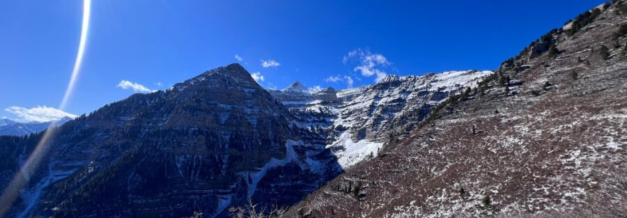
The Primrose Overlook and Horse Spring Trail Loop is a 3.5-mile loop with 950 feet of gain starting from the Battle Creek Trailhead at the end of Battle Creek Drive in Pleasant Grove. The destination is the Primrose Overlook, a high point on the Wasatch Front ridge above the valley with views of the surrounding mountain ranges and the Utah Valley below. The trail climbs through aspen and pine on a well-marked loop and returns to the same trailhead, making it one of the cleaner moderate loop options accessible from the Pleasant Grove residential edge. Battle Creek Falls is the shorter family-friendly waterfall companion from the same trailhead cluster, and the Primrose Overlook loop is the moderate half-day upgrade. Big Baldy (5.7 miles / 3,316 feet gain) is the serious summit option in the same corridor for days when more is appropriate.
Quick Facts
| Trail Name | Primrose Overlook and Horse Spring Trail Loop |
| Location | Uinta-Wasatch-Cache National Forest, near Pleasant Grove, Utah |
| Coordinates | 40.4306 N, 111.6151 W (Battle Creek Trailhead) |
| Distance | 3.5 miles (loop) |
| Elevation Gain | ~950 feet |
| Difficulty | Moderate |
| Time | 2-3.5 hours |
| Dogs Allowed | Yes, on leash |
| Fee | Free |
| View on AllTrails | |
How to Get There
From Pleasant Grove, head east on Pleasant Grove Boulevard, which becomes Battle Creek Drive as you enter the residential canyon area. Follow Battle Creek Drive through the neighborhood to the trailhead at the road’s end. The drive from Pleasant Grove’s main commercial area to the trailhead takes about 10-15 minutes. From Salt Lake City, take I-15 south to Exit 275 (Pleasant Grove/American Fork) and head east on Pleasant Grove Boulevard. From Provo, take I-15 north to the same exit. Total time from Salt Lake City is about 35-40 minutes. From Orem, about 15-20 minutes. The trail is a National Forest route accessible from a residential street. The transition from suburban neighborhood to the Uinta-Wasatch-Cache National Forest happens at the trailhead. Snow covers the upper loop sections from approximately November through April; check current conditions before early-spring or late-fall visits.
Parking Information
The Battle Creek Trailhead parking area at the end of Battle Creek Drive serves multiple trails including the Primrose Overlook loop and the Battle Creek Falls Trail. It fills on weekend mornings from May through September. Arrive before 8 a.m. on peak weekends. No restrooms, no fee. The final blocks of Battle Creek Drive pass through residential streets; park only in the designated trailhead area and not in front of private driveways or residences. 
Cell Service and Navigation
Cell coverage is reasonable at the trailhead and holds through the lower trail sections. It decreases on the upper loop. Download AllTrails offline before heading out. The loop is well-marked and signed; navigation isn’t the challenge here. Having the GPS track active is useful for confirming your position at trail junctions and identifying the Primrose Overlook viewpoint.
What to Expect on the Primrose Overlook Loop
The Climb
The trail from the Battle Creek Trailhead climbs Battle Creek Canyon through aspen and pine forest. The lower section is shaded and relatively gentle, with the creek audible alongside the path through the first portion of the climb. The grade steepens as the loop gains elevation toward the overlook. The most challenging ascent sections come in the upper portion of the loop near the Primrose Overlook, where the trail pushes up the final ridge. Wildflowers in the meadow sections and open areas of the loop through late May and June. Aspen color in late September. The trail surface is well-maintained but includes rocky sections and some loose gravel on steeper portions.
Primrose Overlook
The Primrose Overlook is the high point of the loop with views of Utah Valley, the surrounding Wasatch Range, and the geometry of the valley floor below. The overlook perspective puts you above the urban valley in a way that the lower trails don’t, and the combination of mountain terrain above and the patchwork of cities, fields, and Utah Lake in the valley below is a specific Wasatch Front visual that doesn’t exist from the valley floor. For photography: the overlook faces west and southwest, which makes late afternoon the natural light window. The valley below catches warm light in the last two hours before sunset. Morning visits are quieter in terms of crowd but the light is flat and backlit on the valley. The mountain terrain above and behind the overlook catches morning light well if you want the ridge and peak context rather than the valley view.
The Return
The loop returns to the Battle Creek Trailhead via the Horse Spring section of the trail, which descends through different terrain than the ascent. The loop character of the route gives it a different return experience from an out-and-back; you’re on new ground for the descent rather than reversing the climb. The Horse Spring section passes through denser forest cover and has the spring access point the name references.
Trail Difficulty and Length
Moderate is accurate: the elevation gain is real and the steep sections near the overlook require sustained effort, but the distance is manageable and the loop format means no monotonous retracing. Budget 2-3.5 hours for the full loop at a comfortable pace with time at the overlook.
Dog Friendly?
Yes. Uinta-Wasatch-Cache National Forest allows leashed dogs throughout. The forest sections and the loop terrain are manageable for most trail-fit dogs. Keep dogs leashed on the upper sections where wildlife is more active. Bring water; the creek access in the lower canyon doesn’t extend to the upper loop. 
What to Bring
Water: 2 liters for a moderate 3.5-mile loop. Sun protection for the open sections above the forest canopy near the overlook. Layers for the exposed ridge at the top; wind can be present on the overlook even in summer. Trail runners or hiking boots both work. For photography: mid-range for the valley views and the mountain terrain, wide-angle if you want the full overlook panorama. Late afternoon is the valley-view light window.
Best Time to Hike the Primrose Overlook Loop
Late May through October. The upper loop can hold snow into late April or early May; check current conditions before spring visits. Late May and June bring wildflower color to the meadow sections. September is the best overall month: cool temperatures, less crowded than summer weekends, and aspen color in the canyon by mid-month. Afternoon thunderstorms can develop over the Wasatch Front in July and August. Start by 7-8 a.m. on storm-likely days and plan to be back at the trailhead before noon. The exposed overlook section has some lightning exposure when weather builds above it.
Rules and Regulations
Leave No Trace principles apply. Stay on designated trails to protect fragile vegetation on the upper sections. No campfires in the Uinta-Wasatch-Cache National Forest due to fire restrictions in this corridor; check current status. Dogs on leash. Pack out all trash. 
Where to Stay Near Pleasant Grove
Pleasant Grove, Orem, and Provo have full lodging infrastructure 15-25 minutes from the trailhead. For points travelers, check available Marriott Bonvoy properties in Provo, IHG Rewards hotels in Provo, and Hilton Honors options in Orem. Salt Lake City, about 35-40 minutes north, is the large metro base.
Camping Nearby
American Fork Canyon, accessible from UT-92 a short drive east, has developed campgrounds through recreation.gov. This is the nearest established camping to the Pleasant Grove trailhead area. Dispersed camping on National Forest land outside designated campground boundaries is available with standard rules applying.
Nearby Adventures
Battle Creek Falls Trail is the short companion from the same trailhead cluster: a family-friendly waterfall hike. If the Primrose Overlook loop is the moderate half-day, Battle Creek Falls is the easy option for anyone with younger kids or less available time. Big Baldy from Pleasant Grove is the serious summit option in the same corridor at 5.7 miles / 3,316 feet of gain, for anyone who has done the Primrose Loop and wants the harder commitment from the same general area. Timpanogos Cave National Monument in American Fork Canyon is the non-hiking companion activity for this part of the Wasatch Front: a guided cave tour through limestone formations accessible from UT-92. Horsetail Falls in the Lone Peak Wilderness near Alpine is the companion hard Wasatch Front hike at 4.2 miles with 1,600 feet of gain, accessible a short drive south on I-15. If the Primrose Overlook Loop is the moderate warm-up, Horsetail Falls is what stepping up looks like from here.
Plan This Hike
AllTrails has the Primrose Overlook and Horse Spring Trail Loop mapped with offline capability, junction-level GPS detail, and condition reports from recent hikers. Plan your hike on AllTrails and download the offline map before heading up Battle Creek Drive.
Chase the Quiet
The Wasatch Front is remarkable for the specific compression it offers. From the Primrose Overlook you can see the entire Utah Valley from one edge of the mountains to the other. Cities, lake, farmland, freeway, and then the mountain ranges rising above it all. It’s the same view the valley residents see from below looking up, just inverted, with the mountain as the foreground instead of the background. That inversion shifts how the whole landscape reads. That’s worth the 950 feet to get there.
Support the Adventure
To make your walls less boring, check out my photography portfolio and bring a piece of the wild and my story into your home. If you’d like to fuel future adventures, you can donate a coffee on Ko-Fi. Every cup keeps me chasing sunrises and stories. When you shop using my affiliate links, every click helps support this blog at no extra cost to you. It’s a small way to keep Unicorn Adventure alive and kicking while I keep exploring. Subscribe to my mailing list for future updates, new stories, and behind-the-scenes adventures. Stay connected with me on Instagram and Facebook for more photos and daily inspiration. Thanks for being part of the journey, Unicorn Squadron!

Theo Maynard is a landscape photographer and adventure blogger based in Salt Lake City. He chases remote desert and mountain light across the American West, documents it all solo, and shares the journey through Unicorn Adventure. He’s on the autism spectrum, and that’s not a footnote, it’s the whole story. He creates to inspire others to get outside, chase what lights them up, and live their best possible life. Unapologetically himself.