Kane Creek Boulevard leaves downtown Moab heading south, follows the Colorado River for a stretch of pavement, then turns to dirt and keeps climbing. That’s Hurrah Pass. It runs about 10 miles from town to the pass itself, gaining views of Kane Creek Canyon and the La Sal Mountains along the way, and topping out at a saddle where the desert drops away on both sides and the sense of distance becomes something physical.
This guide covers the Hurrah Pass route from the Kane Creek Boulevard turnoff to the pass and back: vehicle requirements, what the road is actually like, when to go, and what to pair it with for a full Moab day.
Quick Facts
|
Route Name |
Hurrah Pass OHV Route |
|
Location |
BLM Land, near Moab, Utah |
|
Coordinates |
|
|
Distance |
Approx. 20 miles roundtrip (10 miles each way to pass) |
|
Elevation Gain |
Approx. 2,150 feet |
|
Difficulty |
Easy to Moderate (high-clearance recommended in dry conditions) |
|
Time |
3-4 hours roundtrip |
|
Dogs Allowed |
Yes, on leash |
|
Fee |
None (BLM land) |
|
AllTrails |
How to Get There
From downtown Moab, head south on US-191 and turn right onto Kane Creek Boulevard. Follow Kane Creek Boulevard south as it runs along the Colorado River on pavement for several miles. The pavement ends and the dirt road begins as you move into Kane Creek Canyon. Keep following the main track south and uphill. The route is well-traveled and generally well-signed at key junctions. The pass is roughly 10 miles from the Kane Creek Boulevard turnoff in town.
From Salt Lake City, plan about 4 hours: I-15 south, US-6 east, US-191 south into Moab. From Grand Junction, Colorado, roughly an hour west. No entry fee, no reservation required. BLM land. Kane Creek Boulevard is accessible directly from downtown Moab, which makes this one of the most convenient OHV routes in the area, no significant highway driving required to reach the dirt.
Check conditions before heading out. The Kane Creek road can be impassable when wet and flash flood risk in the canyon is real after rain. The Moab BLM Field Office can provide current road conditions.
Cell Service and Navigation
Cell service drops off as you enter Kane Creek Canyon and is unreliable for most of the route. Download AllTrails or a BLM map offline in Moab before heading out.
Navigation on Hurrah Pass is straightforward. The route follows the main road with no ambiguous junctions until you get past the pass into more technical terrain beyond. If you’re turning around at the pass itself, you won’t need to navigate any forks. If you’re continuing toward Chicken Corners or Kane Springs Road, having the offline map becomes more important.
What to Expect on the Hurrah Pass Route
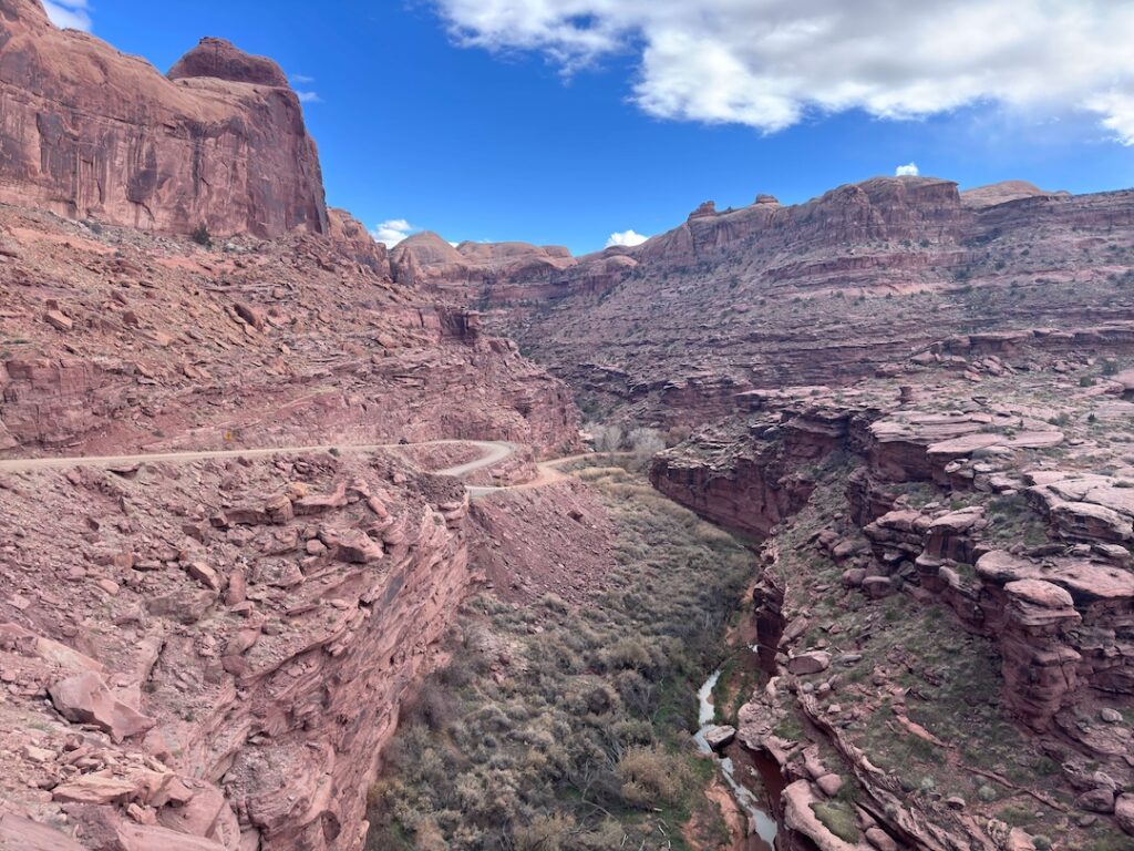
The Road
The first section out of Moab follows Kane Creek Boulevard through a canyon corridor with walls rising on both sides and the creek running close to the road in the lower sections. The terrain is intimate early, canyon walls tight, views focused forward and up. As the road climbs out of the canyon bottom toward the pass, the terrain opens and the scale changes.
The road surface is graded dirt with sections of embedded rock and a few rougher spots on the climb to the pass. In dry conditions, most high-clearance SUVs handle it without drama. The climb is gradual, the road is generally wide enough for two vehicles to pass, and there’s nothing technically demanding before the pass. Past the pass, terrain options get progressively more challenging if you choose to continue.
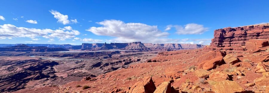
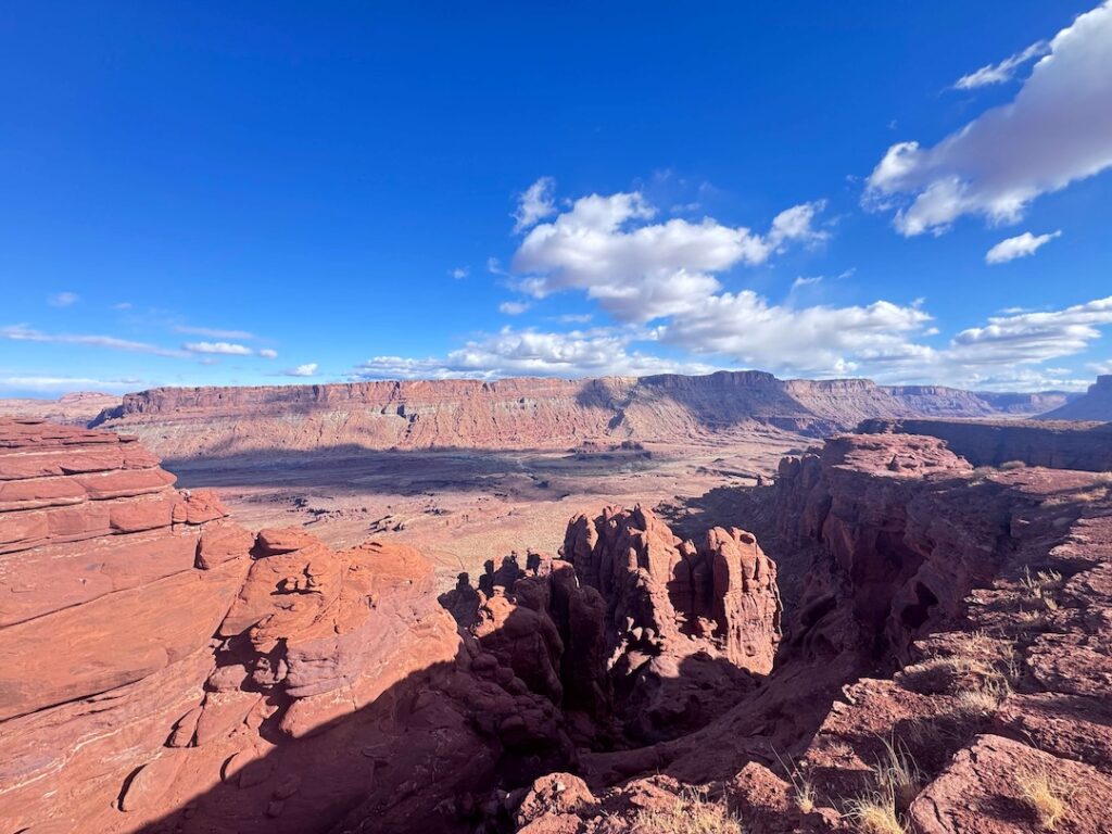
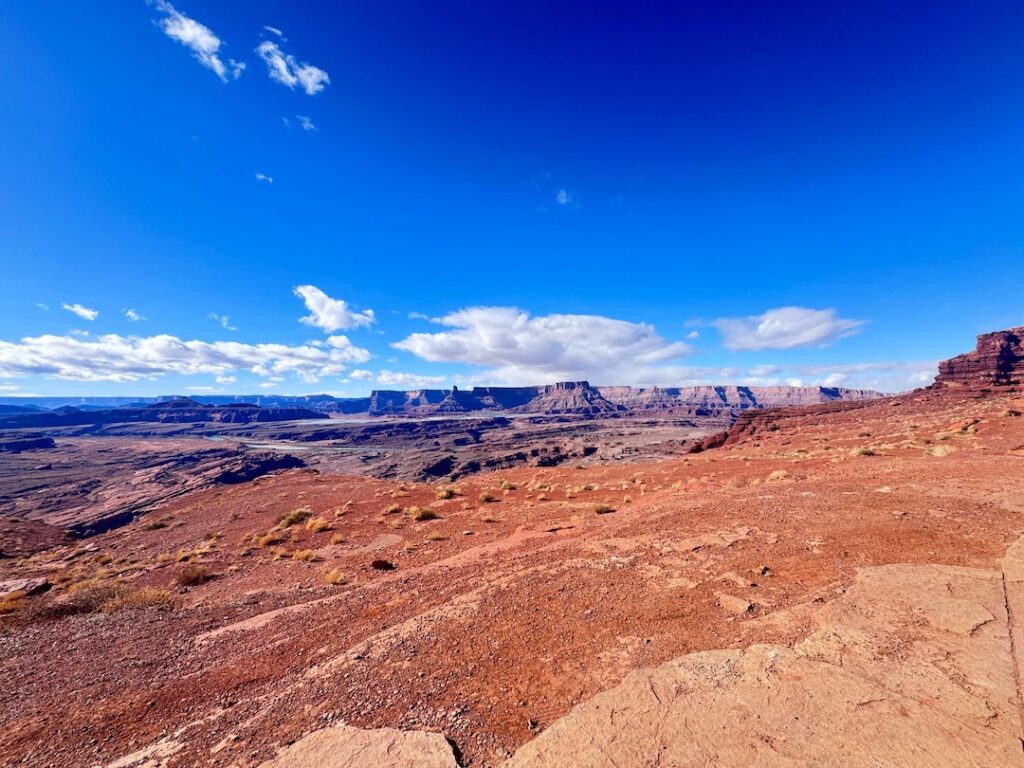
The pass itself is a saddle between two ridgelines with views in both directions: Kane Creek Canyon behind you, the broader desert and Colorado River canyon country ahead. It’s a natural stopping point and the reason most people run this route.
The Views
The pass view is the payoff. Kane Creek Canyon drops behind you to the north with the La Sal Mountains rising to the east, often snowcapped in spring and fall. To the south and west, the terrain opens into a broader canyon system with the Colorado River corridor visible in the distance. On a clear day the view carries well past what you can usefully photograph with a single frame.
The canyon walls on the approach are also worth slowing down for. Red Wingate Sandstone towers over the lower canyon sections, and there are petroglyph panels visible from the road at a few points. Pull over and look at them. Ancient rock art on BLM land doesn’t get roped off or interpreted. It’s just there, at eye level, made by people who lived in this canyon system a long time before it had a road through it.
Drive Difficulty and Length
Easy to moderate is the honest rating for the out-and-back to the pass. The 20-mile roundtrip is straightforward in dry conditions for any high-clearance vehicle with real 4WD. The elevation gain of approximately 2,150 feet comes gradually over 10 miles, not in steep pitches. Nothing about the road to the pass requires technical driving skill or specialized equipment beyond ground clearance.
Budget 3-4 hours for the out-and-back at a comfortable pace with stops for views and photography. If you’re continuing beyond the pass to Chicken Corners or Kane Springs Road, add time and difficulty significantly. Those extensions move into genuinely technical terrain and require more experience and a more capable vehicle.
Wet conditions change the calculus entirely. Kane Creek Road in the rain becomes slick clay that defeats most vehicles. Check the forecast for the full upstream watershed before committing.
Dog Friendly?
Yes. Hurrah Pass is BLM land and dogs are welcome on leash. It’s one of the more dog-friendly OHV routes in the Moab area because the terrain around the pass offers enough space to get out of the vehicle and walk around with your dog safely.
Standard desert dog precautions apply. Bring at least 1 liter of water per dog per hour of activity in warm weather. Watch for cactus spines on the ground near the canyon edges. Keep dogs back from exposed drop-offs near the pass. The desert heat builds fast on exposed rock and your dog will dehydrate before showing obvious signs. Plan water breaks proactively.

What to Bring
For the vehicle: a full-size spare, a tow strap, and a portable air compressor for re-inflating after airing down. Airing down to 20-25 PSI before you hit the dirt improves traction and ride quality on the rocky sections. A shovel rounds out a basic recovery kit.
For you and passengers: water, minimum 2 liters per person plus dog water. Sun protection, hat, sunscreen, sunglasses. The pass is fully exposed and the reflective canyon walls amplify heat in summer. Snacks with salt content for hot-day electrolyte replacement.
For photography: a wide-angle lens for the pass panorama, a mid-range for canyon walls on the approach. The petroglyph panels on the canyon walls reward a longer focal length to pull in detail without getting too close to the rock surface. Morning light on the eastern canyon walls and late afternoon light on the western views both work well from the pass.
Best Time to Drive Hurrah Pass
Spring (March through May) and fall (September through November) are the reliable windows. Temperatures are comfortable, the canyon light has warmth, and the road is reliably dry. Spring occasionally brings wildflowers to the canyon bottom sections of the route.
Summer is doable with an early start. Leave Moab before 7 a.m. and plan to be back in town by noon. The canyon acts as a heat collector by midday and the exposed pass adds to it. The La Sal Mountains backdrop is snow-free and clear in summer, which is good for the view from the pass, but the heat on the drive negates most of the pleasure of stopping.
Winter visits are quiet and can produce excellent photography conditions with the La Sals heavily snowcapped and low-angled light on the canyon walls. The road gets icy and muddy in winter precipitation. Check conditions with the Moab BLM Field Office before committing to a winter run.
For photography, sunrise from the pass looks back toward the La Sal Mountains catching first light. Sunset from the pass looks toward the Colorado River canyon country going orange and red. Both are worth the drive. Plan your direction based on which light window you’re targeting.
Rules and Regulations
Stay on the designated route. The BLM land in Kane Creek Canyon and around the pass is fragile desert terrain with cryptobiotic soil crust that doesn’t recover from tire tracks off established roads. Do not drive around obstacles onto virgin desert surface.
Pack out all trash, including dog waste. Dogs on leash at all times. No fires without a fire pan and current fire restrictions allowing. Flash flood risk in Kane Creek Canyon is real after rain, including rain upstream well away from Moab. Check the full watershed forecast, not just local conditions.
The petroglyph panels along the canyon road are protected under federal law. Do not touch or chalk them. Stay back and photograph from a distance.
Where to Stay Near Moab
Hurrah Pass starts from downtown Moab, which makes the logistics simple: stay in Moab, drive out your front door. The town has lodging at every price point from hostel to river-view resort. Red Cliffs Lodge on the Colorado River on Highway 128 and The Caves at Moab are both options with character. For points travelers, check available Marriott Bonvoy properties in Moab, IHG Rewards hotels near Moab, and Hilton Honors options in the area. Book early for spring and fall.
Camping Nearby
BLM dispersed camping is available along the Kane Creek corridor and in the broader area south of Moab. Several established dispersed sites sit along the lower sections of Kane Creek Road before the terrain gets rocky. Standard BLM rules apply: pack in, pack out, 14-day stay limit, no fires without a fire pan and current restrictions allowing.
The Sandflats Recreation Area east of Moab has both dispersed and fee sites with facilities and is the most organized camping option for Moab OHV-based trips. Porcupine Rim and Gemini Bridges are the other main dispersed camping areas for overlanders working out of Moab.
Nearby Adventures
Chicken Corners is the natural extension if you want to push past the pass. It continues south from Hurrah Pass into progressively more technical canyon rim terrain with exposure that earns its name. Consider it a separate trip commitment rather than a casual add-on if you haven’t driven it before.
Potash Road (UT-279) runs along the north side of the Colorado River west of Moab and offers petroglyph panels, dinosaur tracks visible from the road, and a scenic canyon drive that’s accessible to any vehicle. It’s a completely different character from Hurrah Pass and a good same-day pairing if you want canyon road variety without more dirt.
For hikers in your group, Corona Arch Trail is accessible from Potash Road and runs 3 miles roundtrip to a massive BLM arch with dogs allowed. It’s the best dog-friendly arch hike in the Moab area and combines naturally with a Hurrah Pass day.
Arches National Park is 5 miles north of Moab. Delicate Arch and the Windows Loop and Turret Arch Trail are the marquee hikes inside the park and can round out a morning that started with Hurrah Pass.
Plan This Drive
AllTrails has the Hurrah Pass route mapped with offline GPS tracking. Plan your drive on AllTrails and pull the offline map in Moab before driving out.
Chase the Quiet
Hurrah Pass leaves from downtown Moab and gets you to a saddle 10 miles into BLM country in about an hour of careful driving. The pass view, La Sals one direction and Colorado River canyon country the other, is the kind of payoff that doesn’t require any commitment beyond a high-clearance vehicle and a willingness to drive a dirt road for a while. The reward-to-effort ratio is generous. Take a dog. Take a thermos. Stay for the view.
Support the Adventure
To make your walls less boring, check out my photography portfolio and bring a piece of the wild and my story into your home.
If you’d like to fuel future adventures, you can donate a coffee on Ko-Fi. Every cup keeps me chasing sunrises and stories.
When you shop using my affiliate links, every click helps support this blog at no extra cost to you. It’s a small way to keep Unicorn Adventure alive and kicking while I keep exploring.
Subscribe to my mailing list for future updates, new stories, and behind-the-scenes adventures.
Stay connected with me on Instagram and Facebook for more photos and daily inspiration.
Thanks for being part of the journey, Unicorn Squadron!

Theo Maynard is a landscape photographer and adventure blogger based in Salt Lake City. He chases remote desert and mountain light across the American West, documents it all solo, and shares the journey through Unicorn Adventure. He’s on the autism spectrum, and that’s not a footnote, it’s the whole story. He creates to inspire others to get outside, chase what lights them up, and live their best possible life. Unapologetically himself.