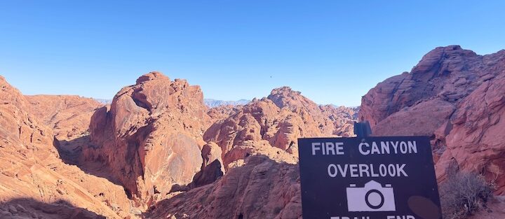
Rainbow Vista Trail is a 1-mile easy walk in Valley of Fire State Park, departing from Mouse’s Tank Road about 4 miles from the visitor center. The trail passes through layered Aztec Sandstone in red, pink, orange, and yellow color bands, the saturated desert color palette that gives Valley of Fire its name, and ends at a Fire Canyon overlook with a wide panoramic view of the surrounding red rock formations and desert basin.
In the Valley of Fire catalog, Rainbow Vista is the mid-ground option: shorter than the Fire Wave / White Domes / Seven Wonders Loop (3.2 miles) and more substantive than the Elephant Rock stop (0.3 miles). The Fire Canyon overlook at the end is the trail’s payoff, a broader desert view than the sandstone formations along the walk provide on their own.
Quick Facts
|
Trail Name |
Rainbow Vista Trail |
|
Location |
Valley of Fire State Park, near Las Vegas, Nevada |
|
Coordinates |
|
|
Distance |
1 mile roundtrip |
|
Elevation Gain |
104 feet |
|
Difficulty |
Easy |
|
Time |
30-60 minutes |
|
Dogs Allowed |
Yes, on leash; hot sand and rock in summer |
|
Fee |
$10 Nevada residents / $15 out-of-state per vehicle |
|
AllTrails |
How to Get There
Valley of Fire is approximately 50 miles northeast of Las Vegas. Take I-15 North to Exit 75 and follow Valley of Fire Highway into the park. The Rainbow Vista Trailhead is on Mouse’s Tank Road, about 4 miles from the visitor center. Park entry fee ($10 Nevada / $15 out-of-state) is paid at the entrance station. The drive from Las Vegas takes about 1 hour.
Mouse’s Tank Road is the park’s primary interior road connecting the visitor center to the eastern park formations. Rainbow Vista Trailhead is clearly marked on the right side of the road coming from the visitor center direction.
Parking Information
Designated parking area at the Rainbow Vista Trailhead on Mouse’s Tank Road. More parking than the Elephant Rock east entrance lot. Spring and fall weekends fill earlier; arrive before 9 a.m. on busy days. The lot is accessible throughout the park visit day since Mouse’s Tank Road is a two-way road rather than the one-way Scenic Loop.

Cell Service and Navigation
Cell coverage is present near the park entrance and decreases inside. Download AllTrails offline before entering the park. Rainbow Vista Trail is a short and well-signed route; navigation is not complex. The trail is self-guided to the Fire Canyon overlook and back.
What to Expect on the Rainbow Vista Trail
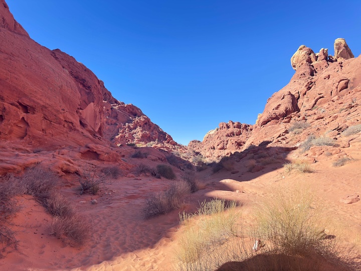
The trail departs the parking area through sandy washes and past the layered Aztec Sandstone formations that characterize Valley of Fire’s interior. The sandstone here displays the full color range: deep reds, oranges, pinks, and yellows in distinct bands that shift in apparent color as the angle of light changes throughout the day. Morning light from the east produces warmer readings on the east-facing formation surfaces; afternoon light from the west illuminates the west-facing walls more directly.
The trail climbs slightly to the Fire Canyon overlook at its end. The overlook delivers a wide panoramic view of the desert canyon terrain, the valley floor visible below with the surrounding Aztec Sandstone formations rising on all sides. The color saturation at this viewpoint in late afternoon is the trail’s photography priority moment.
Deep sand sections slow the pace on parts of the trail; comfortable hiking shoes rather than sandals are appropriate even for this easy walk. The trail is mostly flat with the final climb to the overlook being the only sustained elevation change.
For photography: the layered sandstone formations along the trail approach are subjects throughout. The Fire Canyon overlook for the wide panoramic desert view in late afternoon from the west. Early morning for the east-facing formation surfaces along the trail. Wide-angle for the full canyon overlook panorama, mid-range for the sandstone band color and texture detail. A polarizing filter reduces glare and enhances the color saturation on the rock surfaces.
Trail Difficulty and Length
Easy is accurate: the trail is suitable for all fitness levels and most ages. The deep sand sections on parts of the approach are the only minor difficulty element. Budget 30-60 minutes with time at the overlook.
Dog Friendly?
Yes. Dogs are permitted on leash. The sand surface heats quickly and the rock temperature in summer can be extreme. Early morning visits for dogs in any month from May through September. Bring at least 1 liter of water for dogs; no water source on the trail.
What to Bring
Water even for a short 1-mile walk in the desert, Valley of Fire’s heat and sun exposure make hydration non-optional at any distance. Sun protection. Comfortable shoes with sand traction. Camera with wide-angle and mid-range capability. A polarizing filter for the sandstone color.
Best Time to Visit
Summer (May through September): possible only before 8 a.m. and after 5 p.m.; the 1-mile distance keeps exposure manageable with those constraints. The park may close on extreme heat days; check Nevada State Parks for current alerts before summer visits.
Rules and Regulations
Stay on designated trail. No collecting rocks or disturbing wildlife. No carving on sandstone. No drones. Pack out all trash. Dogs on leash. $10 Nevada / $15 out-of-state park entry fee. Leave No Trace throughout.
Where to Stay Near Valley of Fire
Las Vegas, 50 miles southwest, is the primary base. For points travelers, check available Marriott Bonvoy properties in Las Vegas, IHG Rewards hotels in Las Vegas, and Hilton Honors options in Las Vegas. Valley of Fire State Park’s two in-park campgrounds (Atlatl Rock and Arch Rock) enable overnight visits for the full sunrise and sunset photography windows.
Nearby Adventures
Full Valley of Fire trail catalog: Elephant Rock Trail (0.3 miles / 45 ft, roadside arch at east entrance), Fire Wave / White Domes / Seven Wonders Loop (3.2 miles / 380 ft, the primary moderate day hike), Petroglyph Canyon via Mouse’s Tank Trail (0.7 miles / 49 ft, ancient rock art walk), and Prospect Trail to White Domes Slot Canyon (8.7 miles / 770 ft, full-day slot canyon commitment). Rainbow Vista and Mouse’s Tank Trail together cover the central Mouse’s Tank Road corridor in about 2 hours with minimal effort.
Plan This Hike
AllTrails has Rainbow Vista Trail mapped with offline capability and condition reports. Download before entering the park. Plan your visit on AllTrails and pull the offline map while you’ve got signal on I-15.
Chase the Quiet
Valley of Fire is named for what happens to the Aztec Sandstone in late afternoon light. The Rainbow Vista Trail’s Fire Canyon overlook is the place to watch it happen at the 1-mile scale: the canyon walls shift from warm orange to deep red to purple in the 30 minutes before the sun drops. It’s 30 minutes of active color change on a geological surface that’s been running this same show every clear sunset for millions of years. The audience changes; the rock doesn’t. The 1-mile walk gets you there. That’s an efficient trade.
Support the Adventure
To make your walls less boring, check out my photography portfolio and bring a piece of the wild and my story into your home.
If you’d like to fuel future adventures, you can donate a coffee on Ko-Fi. Every cup keeps me chasing sunrises and stories.
When you shop using my affiliate links, every click helps support this blog at no extra cost to you. It’s a small way to keep Unicorn Adventure alive and kicking while I keep exploring.
Subscribe to my mailing list for future updates, new stories, and behind-the-scenes adventures.
Stay connected with me on Instagram and Facebook for more photos and daily inspiration.
Thanks for being part of the journey, Unicorn Squadron!

Theo Maynard is a landscape photographer and adventure blogger based in Salt Lake City. He chases remote desert and mountain light across the American West, documents it all solo, and shares the journey through Unicorn Adventure. He’s on the autism spectrum, and that’s not a footnote, it’s the whole story. He creates to inspire others to get outside, chase what lights them up, and live their best possible life. Unapologetically himself.