Hayden Peak is 12,479 feet and looks like it from the parking area at Bald Mountain Pass. The summit is visible before you start, which helps with the particular mental calculation that goes into committing to a 2,100-foot gain over 3.5 miles. The math is clear: this is steep. It’s one of the steeper gain-to-distance ratios in the Uintas catalog, and the final push to the summit involves loose scree and real scrambling that earns the hard rating.
This guide covers Hayden Peak from the Bald Mountain Pass trailhead area: what the route involves, why the final push is harder than the distance suggests, and how to plan a safe hard day in the High Uintas.
Quick Facts
|
Trail Name |
Hayden Peak Trail |
|
Location |
High Uintas Wilderness, near Kamas, Utah |
|
Coordinates |
|
|
Distance |
3.5 miles roundtrip |
|
Elevation Gain |
~2,100 feet |
|
Difficulty |
Hard |
|
Time |
4-6 hours |
|
Dogs Allowed |
Yes, on leash |
|
Fee |
Mirror Lake Highway pass: $10 (1-3 day) or $20 (7-day); America the Beautiful Pass accepted |
|
AllTrails |
How to Get There
From Kamas, take Mirror Lake Highway (UT-150) east for approximately 33 miles. The Bald Mountain Pass area is clearly signed; the parking area for both the Bald Mountain Trail and the Hayden Peak approach is at the highest point on the Mirror Lake Highway. The Bald Mountain Trailhead area is the starting point for Hayden Peak. AllTrails and current trail conditions from recent hikers will confirm the exact trailhead for the Hayden approach; verify before your trip.
From Salt Lake City, plan about 1.5-1.75 hours: I-80 east to US-40 east toward Heber City, then UT-248 east to Kamas, then Mirror Lake Highway east. From Park City, Kamas is about 20 minutes south on UT-32.
Mirror Lake Highway closes November 1st and reopens around Memorial Day weekend depending on snowpack. The Hayden Peak approach is inaccessible outside this window. Snow on the upper sections can persist into July in heavy snow years. Check current AllTrails condition reports before planning a June or early July visit.
Parking Information
The Bald Mountain Pass parking area serves both the Bald Mountain Trail and the Hayden Peak approach. It’s the largest developed parking area near the top of the Mirror Lake Highway. Summer weekends fill it early; arrive before 8 a.m. on peak days. The lot has restrooms and information kiosks.
Mirror Lake Highway pass required: $10 for 1-3 days, $20 for 7 days. America the Beautiful Annual Pass accepted. Pay at self-serve kiosks on the highway before reaching the pass area.

Cell Service and Navigation
Cell coverage is absent at the Bald Mountain Pass area and on the Hayden Peak route. Download AllTrails offline before leaving Kamas. The trail has some cairn marking but the upper scree section requires attention to route on the loose rock terrain. Having GPS active helps confirm you’re tracking toward the summit rather than drifting onto a false ridge.
The summit of Hayden Peak is visible from the parking area, which is useful for keeping your orientation throughout the climb. Use the summit as your visual anchor on the ascent.
What to Expect on the Hayden Peak Trail
The Lower Approach
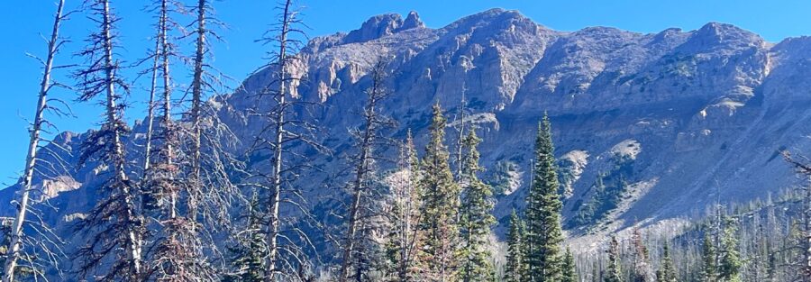
The trail from the Bald Mountain Pass area descends briefly before beginning the sustained climb toward Hayden Peak. The lower section moves through sub-alpine terrain with open views of the surrounding basin and peaks. The trailhead’s high starting elevation means altitude is a factor from the first steps: you’re already above 10,700 feet and going higher.
The alpine lakes visible in the basin below the pass, including the area around Mirror Lake and the smaller Scudder Lake, provide visual orientation as you gain elevation on the ascent. The basin below becomes more expansive with every hundred feet of gain.
The Summit Push
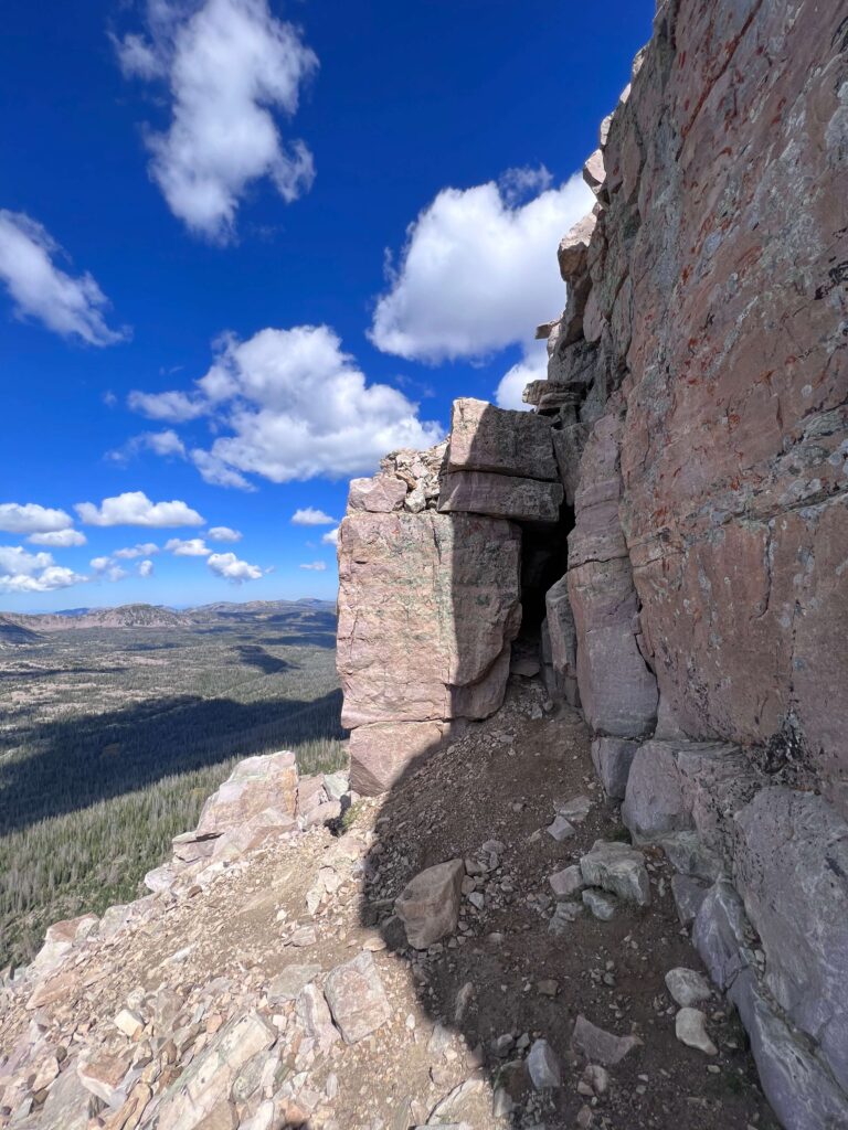
The final approach to Hayden Peak is where the hard rating earns itself. The terrain above the sub-alpine section transitions to open scree and loose rock. The trail becomes less defined and the route follows the line of least resistance up the face. Trekking poles help significantly on the loose sections for both traction on the ascent and balance on the descent.
Some sections involve genuine scrambling, using hands on fixed rock to move through steeper spots. It’s not technical climbing in the roped sense, but it requires comfort with exposed terrain and the ability to read a route up a steep loose slope. Take it slow. The scree can slide underfoot and the descent on the same terrain is more demanding than the ascent for most hikers.
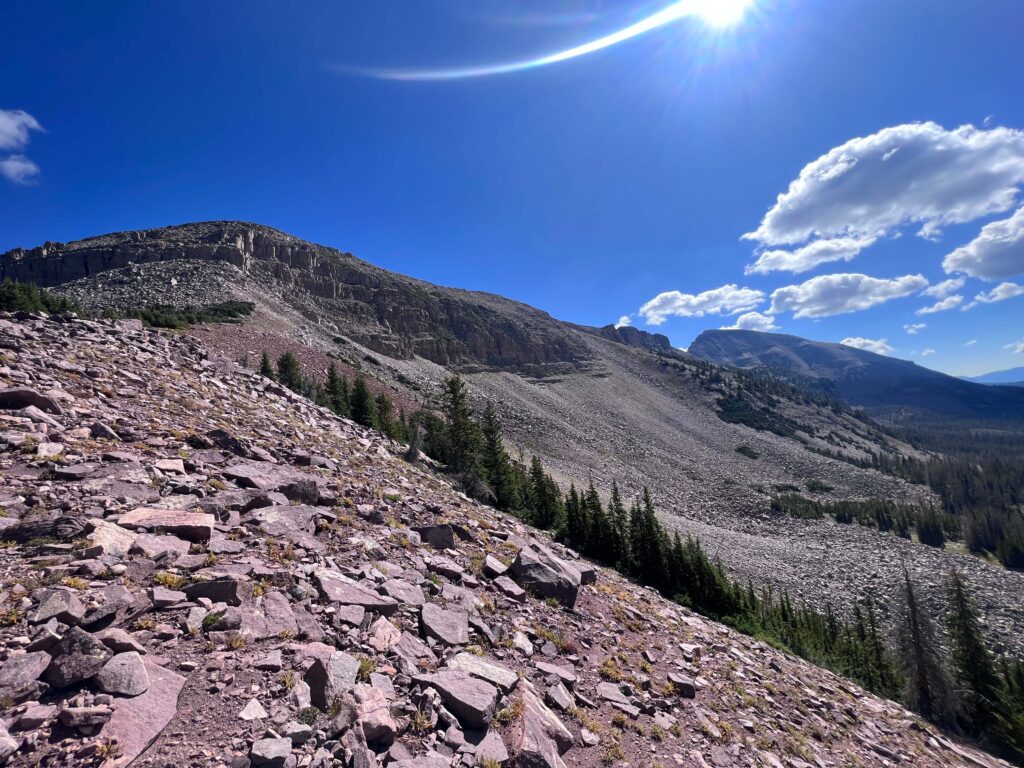
The 12,479-foot summit delivers the panorama the approach earns. The Uinta Mountain ridgeline extends east and west at eye level. The lake country below is laid out in the basin. On a clear day, the High Uintas’ distinctive east-west ridge geometry is legible from this height in a way it isn’t from lower vantage points.
Trail Difficulty and Length
Hard is accurate: the gain-to-distance ratio is steep and the loose scree on the upper section adds difficulty beyond what the mileage alone suggests. This is not a trail where the numbers fully capture the experience.
Plan 4-6 hours for the full roundtrip at a realistic pace with time on the summit. The descent on scree and loose rock typically takes nearly as long as the ascent. Budget time for the descent rather than assuming it will be fast. Tired legs on loose downhill terrain are where ankles get rolled and people fall.
Good fitness is required. The starting elevation at Bald Mountain Pass combined with 2,100 feet of gain to 12,479 feet creates real altitude exposure. Hikers not regularly training at elevation should expect more effort per step than they’re accustomed to on lower-elevation terrain.
Dog Friendly?
Yes, with honest caveats. The High Uintas Wilderness allows leashed dogs throughout. The lower approach is manageable for most trail-fit dogs. The loose scree and scrambling sections on the upper push are harder on dogs that aren’t confident on unstable rocky terrain. Assess your dog’s ability on off-trail rocky terrain before committing them to the upper section.
No reliable water sources on the final ascent. Bring at least 1 liter for your dog in addition to what the lower section streams may provide. Keep dogs leashed at all times and back from exposed edges near the summit.

What to Bring
Water: 3 liters minimum. The high elevation and exposed terrain dehydrate fast. No water sources on the upper section. The lower trail may have stream access but don’t rely on it as your primary strategy.
Layers mandatory: the summit at 12,479 feet can see wind and cold at any time of year. A down or synthetic mid-layer and a waterproof shell are the minimum. Afternoon thunderstorms over the Uintas in July and August create serious lightning risk on an exposed 12,000-foot summit. Start early and commit to a noon turnaround if storms are developing regardless of summit proximity.
Hiking boots with real ankle support and grip on loose rock. Trekking poles for the scree sections and the descent. Sun protection for the fully exposed upper terrain. Snacks for a 4-6 hour day.
Rules and Regulations
Leave No Trace principles apply throughout the High Uintas Wilderness. Pack out everything. No fires above 10,000 feet in most Wilderness areas; check current fire restrictions before your trip. Overnight camping requires a self-registration permit at the trailhead. Day hikes do not require a permit.
Stay on the established trail in the lower section. On the upper scree, walk on rock surfaces rather than on the sparse soil and plant communities between boulders. Dogs on leash at all times. No drones without a special use permit.
Where to Stay Near Kamas
Kamas is the nearest town, about 33 miles west on Mirror Lake Highway, roughly 40-45 minutes from the trailhead. Park City, 20 minutes south of Kamas on UT-32, has full resort infrastructure. Salt Lake City, 1.5 hours west, is the large metro base for Mirror Lake Highway day trips. For points travelers, check available Marriott Bonvoy properties, IHG Rewards hotels, and Hilton Honors options in Park City and Salt Lake.
Camping Nearby
Mirror Lake Campground on the Mirror Lake Highway is the nearest developed option, a few miles west of the Bald Mountain Pass area. Reservations through recreation.gov during peak season. Camping at Mirror Lake sets up an easy early-morning drive to the Bald Mountain Pass parking area for a pre-dawn start on Hayden Peak.
High Uintas Wilderness dispersed backcountry camping is permitted with a self-registration permit. Standard wilderness rules apply. No camping at the Bald Mountain Pass parking area itself.
Nearby Adventures
Bald Mountain Trail from the same Bald Mountain Pass parking area is the accessible companion hike: 2.8 miles roundtrip to 11,943 feet with 360-degree views. It’s the lower-commitment summit from the same lot that pairs well as either a warm-up on the way to Hayden or a standalone option on days when Hayden’s difficulty level isn’t the plan.
Plan This Hike
AllTrails has Hayden Peak mapped with offline capability and condition reports from recent summit attempts. Particularly important for confirming snow status on the upper scree section in June and early July. Plan your hike on AllTrails and pull the offline map before you lose signal on Mirror Lake Highway.
Chase the Quiet
The scree on the Hayden Peak summit push doesn’t reward rushing. You learn that pretty fast. Every step requires a read of the rock ahead and a placement that holds under your weight, and the ones that don’t remind you that speed is the wrong relationship to have with loose terrain at 12,000 feet. Slowing down is the correct move. And when you slow down on Hayden Peak, the Uintas are right there at eye level in both directions, doing what they’ve been doing since the glaciers left. The pace that the summit demands is also the pace at which you actually see it. That’s not a coincidence.
Support the Adventure
To make your walls less boring, check out my photography portfolio and bring a piece of the wild and my story into your home.
If you’d like to fuel future adventures, you can donate a coffee on Ko-Fi. Every cup keeps me chasing sunrises and stories.
When you shop using my affiliate links, every click helps support this blog at no extra cost to you. It’s a small way to keep Unicorn Adventure alive and kicking while I keep exploring.
Subscribe to my mailing list for future updates, new stories, and behind-the-scenes adventures.
Stay connected with me on Instagram and Facebook for more photos and daily inspiration.
Thanks for being part of the journey, Unicorn Squadron!

Theo Maynard is a landscape photographer and adventure blogger based in Salt Lake City. He chases remote desert and mountain light across the American West, documents it all solo, and shares the journey through Unicorn Adventure. He’s on the autism spectrum, and that’s not a footnote, it’s the whole story. He creates to inspire others to get outside, chase what lights them up, and live their best possible life. Unapologetically himself.