

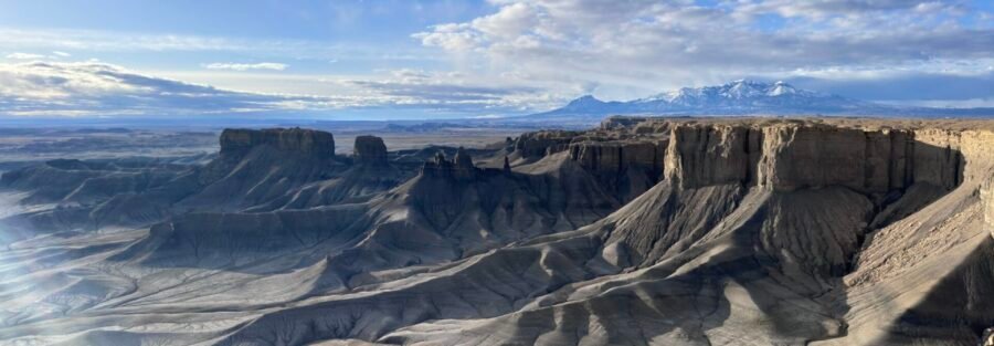
There are places in southern Utah that look like another planet. Moonscape Overlook is one of the more convincing ones.
Moonscape Overlook sits about 12 miles north of Hanksville on BLM land in the San Rafael Swell country. The overlook is reached via a dirt road that requires a high-clearance vehicle and rewards the commitment with a panoramic view of an eroded badlands landscape in muted gray and blue tones that doesn’t look like anything else in Utah. There are no formal trails. You drive out, park, and stand at the edge of one of the stranger views the American West produces.
Here’s everything you need to visit Moonscape Overlook.
Quick Facts
| Destination | Moonscape Overlook |
| Location | North of Hanksville, Utah, BLM land |
| Coordinates | 38.4524, -110.8380 |
| Access | High-clearance vehicle required on dirt road |
| Distance | Roadside overlook, optional off-trail exploration |
| Elevation Gain | None at overlook |
| Difficulty | Easy (with high-clearance vehicle) |
| Dogs Allowed | Yes (on leash) |
| Fee | None |
How to Get There
From Hanksville, drive west on UT-24 for approximately 6 miles. Turn right onto Factory Butte Road, a dirt road heading north toward Factory Butte. Drive about 4 miles, then turn left onto a smaller unmarked dirt road. Follow this road approximately 2 miles to the overlook. Load the coordinates (38.4524, -110.8380) before leaving Hanksville since there are no signs on the approach roads. The dirt road is navigable in dry conditions with high clearance. After rain, the clay surface becomes extremely slick and impassable. Do not attempt this road in wet conditions or if rain is forecast. Estes handles it comfortably in dry weather. A standard passenger car should not attempt it.
Parking Information
No formal lot. Park at the overlook edge without blocking the road. The area is remote enough that multiple vehicles are rarely present simultaneously. No facilities, no restrooms, no trash bins. Everything you bring in comes back out with you. This is genuine desert BLM land. Plan accordingly before leaving Hanksville.

Cell Service and Navigation
No cell service in this area. Signal disappears before you turn off UT-24. Download offline maps before leaving Hanksville. A dedicated GPS unit is the most reliable navigation tool on the approach roads since AllTrails signal dependency won’t work here. Let someone know your plans, your destination coordinates, and your expected return time before heading out. This is remote desert with no nearby services.
What to Expect at Moonscape Overlook
The Overlook
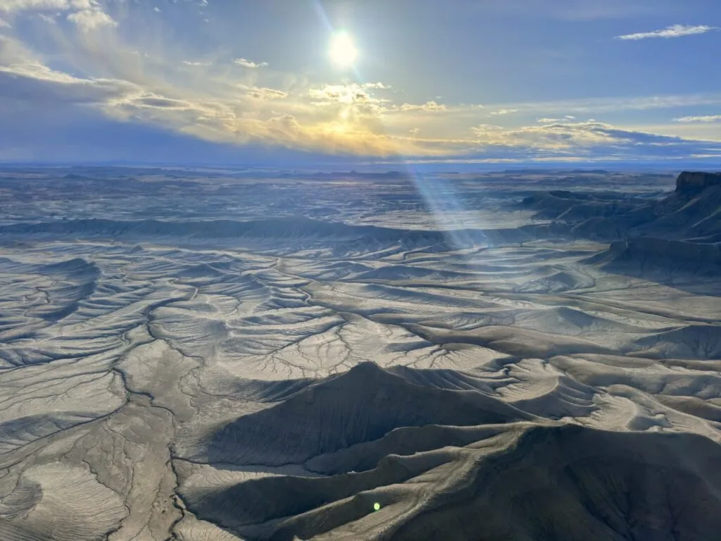
The viewpoint opens onto a sweeping expanse of eroded badlands in muted gray, blue, and tan tones. The terrain below is a maze of ridges, canyons, and plateaus carved by erosion into forms that have no Utah-desert-red about them. This is a different color palette entirely: cooler, more lunar, genuinely strange. The scale is difficult to read without reference points. Distant ridgelines look close. Canyons that appear shallow are deep. The flatness of the approach road does nothing to prepare you for the drop-off when the overlook appears.
Off-Trail Exploration
There are no marked trails. Visitors who want more than the overlook view can walk the edge or venture into the surrounding badlands terrain on their own route. The ground is uneven and loose in places. Steep drop-offs exist near the overlook edge. Move carefully, watch your footing, and stay oriented using your GPS track since the badlands terrain is disorienting at ground level. Off-trail exploration can range from 30 minutes to several hours depending on how far you push. Bring more water than you think you need.
Difficulty and Access
The overlook itself requires no hiking. The difficulty is entirely in the approach: the unmarked dirt roads require a high-clearance vehicle and dry conditions. Once you’re there, the overlook is accessible to anyone who can stand at a viewpoint. Off-trail exploration adds physical demand depending on how far you venture. The terrain is rough underfoot and the desert heat amplifies the effort. This is not a location with any safety infrastructure. Self-sufficiency is assumed.

Dog Friendly?
Yes. Dogs are welcome on leash. The overlook terrain is manageable for most dogs at the edge. If you venture into the off-trail badlands the terrain gets rougher and the steep sections require more care with a dog on a lead. Bring significantly more water than you think your dog needs. The desert floor heats up fast and there are no shade or water sources anywhere on the approach or at the overlook.
What to Bring
At least 2 to 3 liters of water per person even for a short overlook visit. The desert will drain you faster than the casual access suggests. Sun protection from head to toe. A camera with a wide-angle lens for the panoramic landscape and a telephoto for the distant ridge detail. A tripod for sunrise and sunset when the low light on the gray badlands is at its most dramatic. Offline maps loaded before you leave the highway. A shovel in the vehicle in case you get stuck on a soft section of the road. First aid kit. Someone who knows where you’re going.
Best Time to Visit Moonscape Overlook
Spring (March through May) and fall (September through November) are the best windows. Temperatures are manageable and the light on the gray badlands is excellent. Summer temperatures regularly exceed 100°F on this exposed desert terrain and the dirt roads get dangerously soft after monsoon rain. Winter is cold but the light is long and the landscape is beautiful when dusted with snow. The mud risk after any precipitation is the primary year-round access constraint.
For photography, sunrise and sunset are by far the best light. The overlook faces west and southwest, which means sunset light hits the badlands directly and the gray and blue tones take on warmth they don’t have at any other time of day. Arrive 30 minutes before sunset and stay until the light drops. Sunrise catches the eastern ridgelines in first light while the foreground badlands are still in shadow, creating strong depth and contrast. A wide-angle lens handles the panorama. A graduated ND filter manages the bright sky-to-dark-terrain contrast.
Rules and Regulations
Moonscape Overlook is BLM land. No permits, no fees. Leave No Trace fully: pack out everything, stay on rock or established tracks to avoid damaging the desert crust, and respect the fragility of the badlands terrain near the overlook edge. Don’t drive off the established dirt track. The desert crust in this region takes decades to recover from vehicle damage. Check current road conditions with the BLM Price Field Office before heading out, particularly after any recent precipitation.
Where to Stay Near Hanksville
Hanksville has basic motel lodging and serves as a practical base for San Rafael Swell and Henry Mountains exploration. For more amenities, Moab is about 2 hours east and Green River is about 1.5 hours north on I-70. For points travelers, check available Marriott Bonvoy properties, IHG Rewards hotels, and Hilton Honors options in Moab, Green River, or Salt Lake City along your route.
Camping Nearby
Dispersed BLM camping is available throughout the Factory Butte and San Rafael Swell area surrounding Moonscape Overlook. No hookups, no reservations, no facilities. The desert around Factory Butte is one of the better dispersed camping landscapes in Utah with dramatic formations and exceptional night sky access. Goblin Valley State Park, about 30 minutes west, has a campground with hookups reservable through Utah State Parks.
Nearby Adventures
Factory Butte is the most obvious companion destination: a dramatic isolated mesa rising from the desert floor about 4 miles from the Moonscape Overlook approach road. The area around the butte is popular for OHV use and hiking the base offers additional badlands views from a different angle. It’s a natural pairing for the same day.
Goblin Valley State Park is about 30 minutes west and one of the most distinctive landscapes in southern Utah. The Valley of the Goblins is open exploration through thousands of sandstone hoodoos with the Goblin’s Lair Trail and Carmel Canyon Trail as additional park objectives. Little Wild Horse Canyon (8.0 mi / 787 ft) is the premier slot canyon in the immediate area, about 30 minutes northwest.
Leprechaun Canyon (2.2 mi / 147 ft) off Highway 95 is a shorter slot canyon option for the same multi-day trip. Natural Bridges National Monument is about an hour south on Highway 95 with three massive natural bridges accessible via a scenic loop drive.
For established Escalante area trail hikes, Moki Dugway is a spectacular road that works well as a transition route between the Hanksville area and the Cedar Mesa / Monument Valley corridor to the south.
Chase the Quiet
Most of the famous Utah landscapes are red. Arches, Canyonlands, Zion: all red. Moonscape Overlook is gray and blue and alien, a completely different color register, and almost nobody goes there. The dirt road keeps the casuals out and the reward is a panoramic view of badlands terrain that looks genuinely unlike anything else in the state. That trade is worth the high-clearance requirement and the drive out from Hanksville every time.
Support the Adventure
To make your walls less boring, check out my photography portfolio and bring a piece of the wild and my story into your home.
If you’d like to fuel future adventures, you can donate a coffee on Ko-Fi. Every cup keeps me chasing sunrises and stories.
When you shop using my affiliate links, every click helps support this blog at no extra cost to you. It’s a small way to keep Unicorn Adventure alive and kicking while I keep exploring.
Subscribe to my mailing list for future updates, new stories, and behind-the-scenes adventures.
Stay connected with me on Instagram and Facebook for more photos and daily inspiration.
Thanks for being part of the journey, Unicorn Squadron!

Theo Maynard is a landscape photographer and adventure blogger based in Salt Lake City. He chases remote desert and mountain light across the American West, documents it all solo, and shares the journey through Unicorn Adventure. He’s on the autism spectrum, and that’s not a footnote, it’s the whole story. He creates to inspire others to get outside, chase what lights them up, and live their best possible life. Unapologetically himself.