The Natural Bridges Loop might be the best trail in southern Utah that nobody talks about. No crowds. No permit lottery. Just 8.1 miles of canyon bottom solitude, three jaw-dropping natural bridges, and enough Ancestral Puebloan ruins to make your head spin. Natural Bridges National Monument sits on Cedar Mesa near Blanding, and it feels like a place the rest of the world forgot. That suited me just fine.
Quick Facts
Trail Name | Under the Natural Bridges Loop |
Location | Natural Bridges National Monument, near Blanding, Utah |
Coordinates | |
Distance | 8.1 miles (loop) |
Elevation Gain | ~1,082 feet |
Difficulty | Moderate to Strenuous |
Time | 4 to 6 hours |
Dogs Allowed | No (service animals only) |
Fee | $10 per vehicle; America the Beautiful pass accepted |
AllTrails |
How to Get There
From Blanding, head south on US-191 for about four miles until you hit UT-95. Turn west and drive roughly 30 miles to the signed Natural Bridges road on the right. The monument entrance is another 4.5 miles from the highway. From Hanksville, take UT-95 south for about 96 miles to the same turnoff.
The loop starts at the Sipapu Bridge trailhead, which you’ll reach by following Bridge View Drive (the one-way loop road) past the visitor center. Stop at the visitor center first. Grab a trail map, check conditions, and fill your water bottles. There’s no water on the trail. Zero.
Parking Information
Parking is plentiful, with designated lots at each of the three bridge trailheads. The main lot at the visitor center has room for cars, RVs, and trailers. The entrance fee is $10 per vehicle, or free with your America the Beautiful pass.
Restrooms and water fountains are available at the visitor center but not along the trail. Fill up before you leave. The park is open year-round, but visitor center hours vary seasonally.
What to Expect on the Natural Bridges Loop
This trail is primitive. That’s not a warning. It’s an invitation. You’ll descend into deep canyons, follow sandy washes, scramble over slickrock, and navigate sections where the trail all but disappears into the creek bed. The National Park Service classifies the full loop as primitive and strenuous. It earns both of those words.
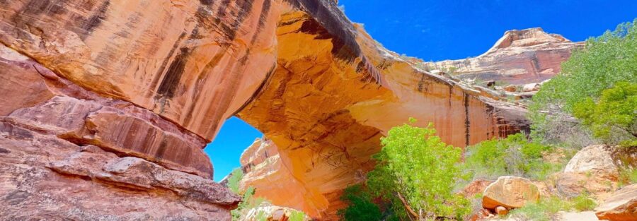
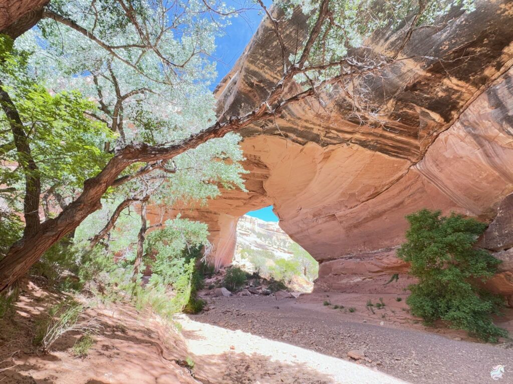
The Descent to Sipapu Bridge
The trail drops from the mesa rim into White Canyon via a series of staircases and ladders. It’s steep but manageable. Before you hit canyon bottom, take the short spur trail to the Sipapu overlook on your left. This is the money shot. Sipapu Bridge spans 268 feet across the canyon, and from up here it looks impossible. Like the canyon just decided to leave a roof on.
Sipapu is the second largest natural bridge in the world. Standing beneath it feels different than looking at it. The scale swallows you. I stood there for a long time, camera down, just taking it in. Some moments don’t belong behind a viewfinder.
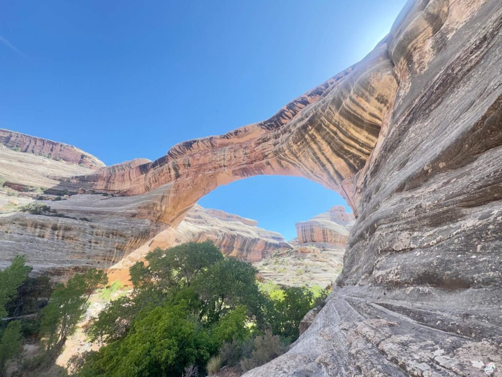
Through White Canyon to Kachina Bridge
From Sipapu, the trail follows White Canyon downstream. This section is where the route gets real. The path is unmaintained and unmarked in places. You’ll bushwhack through tamarisk and willow, hop over dry creek beds, and pick your line through loose sand. When the trail vanishes, follow the canyon bottom. It always brings you back.
Keep your eyes up and to the right. There are cliff dwellings tucked into the sandstone high on the canyon walls. Not far below Sipapu, Deer Canyon comes in from the right, and you’ll spot pictograph panels on the west side. These are the quiet details that make this hike special. You’re not just walking through geology. You’re walking through history.
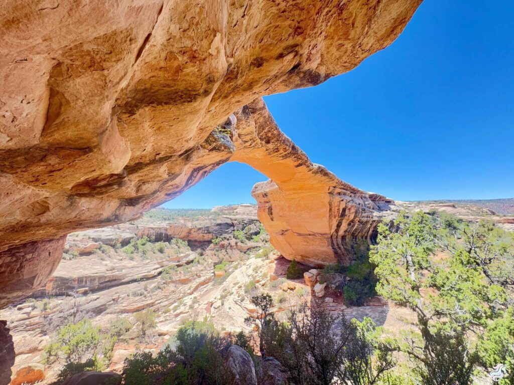
Kachina Bridge appears after about two miles of canyon travel. Look for petroglyphs on the left side as you approach. On the downstream side, there are more petroglyphs and ruins in a shallow alcove. Don’t skip them. Kachina is the youngest of the three bridges, still thick and massive where water continues to carve it. It feels alive.
Armstrong Canyon to Owachomo Bridge
Past Kachina, the trail leaves White Canyon and enters Armstrong Canyon. You’ll hit a junction here. Left takes you up to the Kachina trailhead for a shortcut back. Right continues to Owachomo. Take the right.
The trail climbs to a bench above Armstrong Canyon, bypassing a dry waterfall, then drops back down. Watch for a side canyon entering from the left. One bend above it, there’s a ruin tucked in an alcove on the right. It’s easy to miss if you’re not looking.
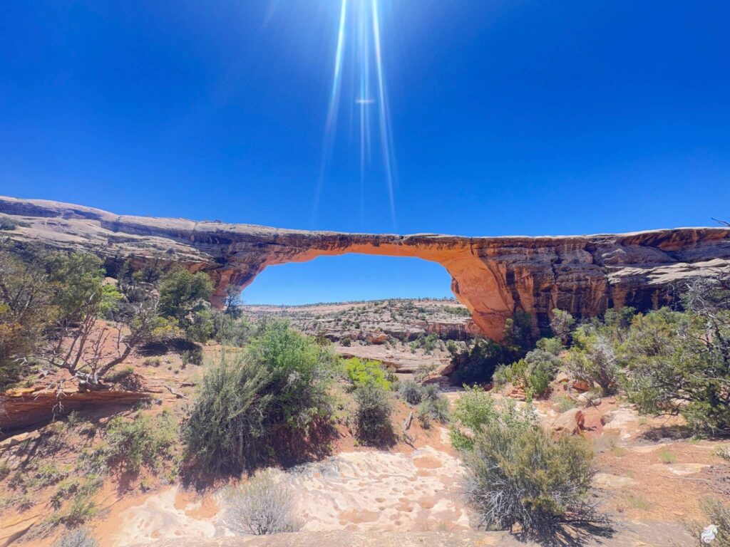
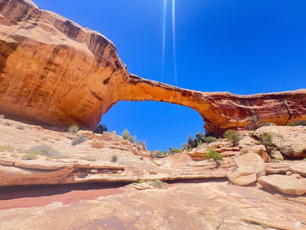
Owachomo is the oldest and thinnest of the three bridges. It spans Armstrong Canyon with a delicate, almost fragile look. The name means “rock mound” in Hopi. Unlike Sipapu and Kachina, Owachomo is small enough to feel intimate. You can see how thin the bridge has become, and you start to understand that this landscape is always moving, always changing, just on a timeline that dwarfs yours.
The Mesa Trail Home
From Owachomo, the trail climbs back to the rim and crosses the mesa top to return to the Sipapu trailhead. This section is flat, exposed, and offers zero shade. Bring more water than you think you need. The mesa trail is less scenic than the canyon bottom, but the quiet openness of it hit me in a way I didn’t expect. The pinyon and juniper stretched out under a wide sky, and I could hear my own footsteps for the first time in hours. That’s the kind of silence that resets you.
Trail Difficulty and Length
The Under the Natural Bridges Loop covers 8.1 miles with about 1,082 feet of elevation gain. The trail involves steep descents, rocky terrain, ladder climbs, and several creek crossings. Expect scrambling near Sipapu and Kachina. Allow 4 to 6 hours depending on your pace and how much time you spend at each bridge.
The trail is well-marked from the rim but gets tricky to follow in the canyon bottom, especially after rain. Bring a trail map or GPS. The sandy sections slow you down more than you’d expect. This is not a casual stroll. It’s a real hike that earns its moderate-to-strenuous rating.
Dog Friendly?
No. Pets are not allowed on any trails in Natural Bridges National Monument. Service animals only. Dogs are permitted in parking areas and along paved roads but must remain leashed at all times. If you’re traveling with a dog, nearby BLM lands have fewer restrictions..
What to Bring
Water. At least three liters per person, more if you’re hiking in summer. There are no water sources you can rely on. Wear sturdy hiking boots with ankle support. The terrain shifts between sand, slickrock, and rocky scrambles, sometimes in the same quarter mile. Long pants are smart for the brushy canyon sections. Pack sun protection (hat, sunscreen, sunglasses), snacks, and a headlamp in case the hike takes longer than planned. A trail map or GPS is helpful since the canyon bottom route is unmarked.
Best Time to Hike the Natural Bridges Loop
Spring (March through May) and fall (September through November) are the sweet spots. Summer temperatures on Cedar Mesa regularly push past 100°F, and the mesa return has no shade. Winter brings cold temps and potential ice on the ladders and slickrock sections.
If you can swing a weekday visit in April or October, you might have the entire canyon to yourself. I saw exactly zero other hikers on my loop. That kind of solitude is rare in Utah’s national parks and monuments.
Sunrise and sunset are magical times to visit. The soft light illuminates the bridges and casts dramatic shadows across the canyon walls. If you’re a photographer, plan to be at Owachomo Bridge at sunset for some of the best lighting in the park.
Rules and Regulations
Natural Bridges National Monument is a designated International Dark Sky Park. Visitors are encouraged to minimize light pollution and enjoy the night skies.
Stay on designated trails to protect the fragile desert ecosystem. Do not touch, climb on, or disturb petroglyphs, pictographs, or ruins. These are sacred cultural sites and they are irreplaceable. Camping is only allowed in designated campgrounds. Fires are restricted to established fire rings. Pack out everything you pack in.
Flash floods can rip through these canyons with little warning. Check the weather before you go, and never enter the canyon during or after heavy rain.
Where to Stay Near Natural Bridges
Natural Bridges National Monument has a small, first-come, first-served campground with 13 sites. No hookups, no reservations. It fills early in peak season, so arrive before noon if camping is your plan.
The town of Blanding, about 40 miles east, has motels and a few restaurants. It’s not glamorous. It’s functional. Mexican Hat and Bluff to the south offer more character and closer access to Valley of the Gods, Goosenecks State Park, and Monument Valley. For points travelers, check available Marriott Bonvoy properties, IHG Rewards hotels, and Hilton Honors options in the broader Four Corners area.
Nearby Adventures
If you’re already out on Cedar Mesa, you’re in the heart of some of the best remote adventure in the American West. Don’t leave without hitting a few more spots.
The Moki Dugway is one of the most dramatic stretches of road in Utah, a gravel switchback carved into a sheer cliff face that drops 1,100 feet. If you drove up from Mexican Hat, you already know. If you haven’t, add it to the list.
Butler Wash Interpretive Trail in Bears Ears National Monument is a short 0.9-mile hike with 108 feet of gain that leads to a viewpoint overlooking well-preserved Ancestral Puebloan cliff dwellings. Easy, quick, and well worth the stop.
Monarch Cave via Comb Ridge is another short hike at 1.6 miles with 127 feet of gain. Some of the most impressive ruins in the area.
Valley of the Gods is a 17-mile dirt loop that feels like Monument Valley without the entrance fee or the crowds. Goosenecks State Park is a quick stop with one of the most photographed river bends in the state. And if you’re heading west toward Escalante, the Escalante Natural Bridge is an easy riverside hike to another stunning sandstone arch.
For a unique cultural experience, head to the Edge of the Cedars State Park Museum in Blanding. Small but excellent. The collection includes pottery, tools, and a well-preserved kiva from the Ancestral Puebloan period.
For food, stop by Comb Ridge Eat and Drink in Bluff for farm-to-table fare with red rock views. It’s the best post-hike meal in the area.
For an all-day adventure, the Grand Gulch Primitive Area is a vast, rugged canyon system filled with Ancestral Puebloan ruins and rock art. Permits are required for overnight trips, and the terrain is challenging but incredibly rewarding.
Plan This Hike
Ready to hit the trail? Download the trail map, check current conditions, and log your hike on AllTrails.
AllTrails gives you offline maps, GPS tracking, and real-time trail conditions. It’s the first app I open before every hike.
Chase the Quiet
The Natural Bridges Loop gave me something I didn’t know I was looking for. Not just three massive bridges carved by water and time. Not just ruins left behind by people who lived here centuries ago. It gave me quiet. Real, deep, uninterrupted silence in a landscape so old it makes your problems feel small.
Support the Adventure
To make your walls less boring, check out my photography portfolio and bring a piece of the wild and my story into your home.
If you’d like to fuel future adventures, you can donate a coffee on Ko-Fi. Every cup keeps me chasing sunrises and stories.
When you shop using my affiliate links, every click helps support this blog at no extra cost to you. It’s a small way to keep Unicorn Adventure alive and kicking while I keep exploring.
Subscribe to my mailing list for future updates, new stories, and behind-the-scenes adventures.
Stay connected with me on Instagram and Facebook for more photos and daily inspiration.
Thanks for being part of the journey, Unicorn Squadron!

Theo Maynard is a landscape photographer and adventure blogger based in Salt Lake City. He chases remote desert and mountain light across the American West, documents it all solo, and shares the journey through Unicorn Adventure. He’s on the autism spectrum, and that’s not a footnote, it’s the whole story. He creates to inspire others to get outside, chase what lights them up, and live their best possible life. Unapologetically himself.