Some hikes hit you with distance. Others hit you with elevation. Butler Wash Interpretive Trail hits you with time. Seven hundred years of it.
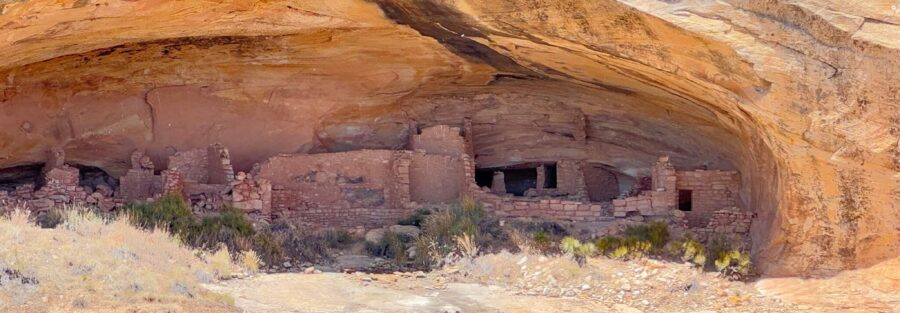
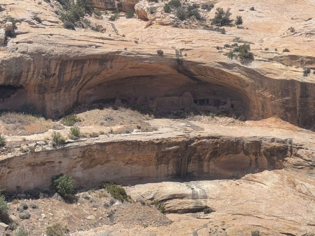
This short trail sits just off Highway 95 in Bears Ears National Monument, about 15 miles west of Blanding, Utah. It leads to a viewpoint overlooking ancient Ancestral Puebloan cliff dwellings tucked into a massive sandstone alcove. Stone rooms. Granaries. Petroglyphs etched into rock walls. All remarkably preserved and completely visible from the overlook. Butler Wash Interpretive Trail packs more history per step than almost any trail in the state.
Quick Facts
Trail Name | Butler Wash Interpretive Trail |
Location | Bears Ears National Monument, near Blanding, Utah |
Distance | 0.9 miles (out and back) |
Elevation Gain | ~108 feet |
Difficulty | Easy |
Time | 30 to 45 minutes |
Dogs Allowed | Yes (leashed) |
Fee | Free. No fees, no passes required. |
AllTrails |
How to Get There
From Blanding, drive west on Highway 95 for about 15 miles. The trailhead parking area sits on the left side of the road. It’s well-marked with a sign, a trail map, and information about the site. You can’t miss it.
The drive takes roughly 20 minutes on a smooth, paved road. If you’re coming from the west, the trailhead is about 40 miles east of Natural Bridges National Monument. Either direction, the approach is straightforward. No dirt roads. No 4×4 required. Estes appreciated the day off.
What to Expect on the Butler Wash Interpretive Trail
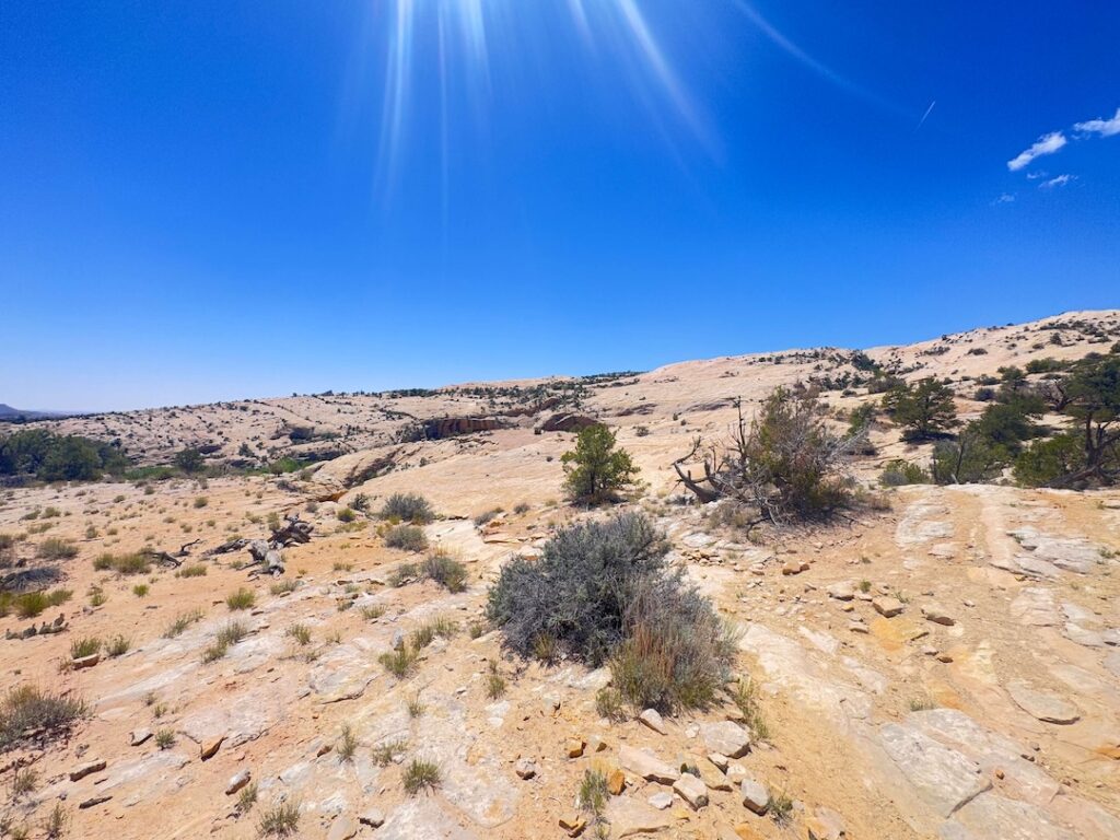
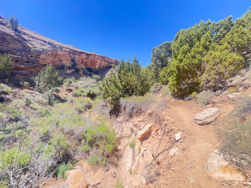
The trail winds through classic southeast Utah desert. Red rock cliffs. Pinon pine. Juniper trees. Sandy wash. The path gradually climbs to a viewing area perched above the cliff dwellings.
The ruins sit inside a massive alcove, sheltered from centuries of weather and remarkably intact. You can clearly make out stone structures, storage granaries, and petroglyphs carved into the rock face. Interpretive signs along the trail explain who the Ancestral Puebloans were, how they built these structures, and what daily life looked like in this harsh desert environment.
The viewpoint gives you a wide perspective of the entire site. Comb Ridge stretches out behind the ruins. The desert rolls to the horizon. Bring a good lens. This place photographs beautifully in morning or late afternoon light.
Trail Difficulty and Length
Butler Wash Interpretive Trail covers 0.9 miles round trip with about 108 feet of elevation gain. It’s flat, well-maintained, and clearly marked. Families, beginners, and anyone who just wants a short walk with a massive payoff will feel right at home here.
The surface is sandy, and it gets hot during midday. Wear sturdy shoes. Bring water. A hat and sunscreen go a long way out here.
Dog Friendly?
Yes. Dogs are welcome on the Butler Wash Interpretive Trail but must stay on a leash. The sandy terrain gets scorching hot in summer, so bring plenty of water for your pup and consider protective booties.
Keep dogs on the main trail and away from the ruins. Pets are not allowed near the archaeological site itself.
What to Bring
This is a short hike, but the desert doesn’t care about your mileage. Bring at least a liter of water per person, more in summer. Wear sturdy shoes or hiking sandals with grip. The trail surface shifts between sand and slickrock. Sun protection is non-negotiable: hat, sunscreen, sunglasses. Snacks if you’re making a day of the Blanding area. A good camera or telephoto lens if you want detail shots of the ruins from the overlook.
Best Time to Hike Butler Wash Interpretive Trail
Spring (March through May) and fall (September through November) are the sweet spots. Daytime highs in the 60s and 70s make for comfortable hiking. The desert colors pop, and the light is perfect for photography.
Summer gets brutal. Temps push into the 90s. If you visit in summer, start early or go late in the afternoon. Midday sun on exposed sand is no joke. Winter is quieter, with cooler temperatures and fewer visitors. Expect chilly mornings and the occasional dusting of snow.
Rules and Regulations
Butler Wash falls under Bears Ears National Monument, managed by the Bureau of Land Management. Leave No Trace rules apply.
Stay on the designated trail. Do not enter the cliff dwellings. The ruins are extremely fragile, and climbing on them causes irreversible damage. Removing artifacts, disturbing petroglyphs, or touching structures is illegal. Camping and fires are not permitted in the area. Drones are prohibited.
Respect the site. These structures survived 700 years. Let’s keep it that way.
Where to Stay Near Butler Wash
The town of Blanding, about 15 miles east, has motels and a few restaurants. It’s not glamorous. It’s functional. Bluff, about 25 miles south, offers more character and closer access to Valley of the Gods, Goosenecks State Park, and Monument Valley. For points travelers, check available Marriott Bonvoy properties, IHG Rewards hotels, and Hilton Honors options in the broader Four Corners area.
Nearby Adventures
If you’re already out near Blanding and Bears Ears, you’re in the heart of some of the best remote adventure in the American West. Don’t leave without hitting a few more spots.
Monarch Cave via Comb Ridge is a short 1.6-mile hike with 127 feet of gain that leads to some of the most impressive ruins in the area. Easy, quick, and well worth the stop.
The Natural Bridges Loop covers 8.3 miles with 1,082 feet of gain. This trail runs through White Canyon past three distinct natural bridges: Sipapu, Kachina, and Owachomo. Each one has its own character, cultural history, and jaw-dropping views. It’s one of the best hikes in the region.
The Moki Dugway is one of the most dramatic stretches of road in Utah, a gravel switchback carved into a sheer cliff face that drops 1,100 feet. If you drove up from Mexican Hat, you already know. If you haven’t, add it to the list.
For deeper cultural immersion, consider booking a guided tour with a local Navajo guide. Many tours offer access to areas closed to the general public, with real insight into the history and significance of the ruins.
Non-Hiking Attractions Nearby
Head back to Blanding and check out the Edge of the Cedars State Park Museum. Small but excellent. The collection includes pottery, tools, and a well-preserved kiva from the Ancestral Puebloan period.
For food, the Patio Drive-In in Blanding is a local favorite for burgers and shakes. If you want something more elevated, Comb Ridge Eat and Drink in Bluff serves farm-to-table food with red rock views.
Plan This Hike
Ready to hit the trail? Download the trail map, check current conditions, and log your hike on AllTrails.
AllTrails gives you offline maps, GPS tracking, and real-time trail conditions. It’s the first app I open before every hike.
Chase the Quiet
Butler Wash gave me something I keep coming back to. Not just a viewpoint overlooking ancient ruins. Not just an easy hike in a beautiful place. It gave me a moment of stillness in a landscape so old it makes your problems feel small.
Support the Adventure
To make your walls less boring, check out my photography portfolio and bring a piece of the wild and my story into your home.
If you’d like to fuel future adventures, you can donate a coffee on Ko-Fi. Every cup keeps me chasing sunrises and stories.
When you shop using my affiliate links, every click helps support this blog at no extra cost to you. It’s a small way to keep Unicorn Adventure alive and kicking while I keep exploring.
Subscribe to my mailing list for future updates, new stories, and behind-the-scenes adventures.
Stay connected with me on Instagram and Facebook for more photos and daily inspiration.
Thanks for being part of the journey, Unicorn Squadron!

Theo Maynard is a landscape photographer and adventure blogger based in Salt Lake City. He chases remote desert and mountain light across the American West, documents it all solo, and shares the journey through Unicorn Adventure. He’s on the autism spectrum, and that’s not a footnote, it’s the whole story. He creates to inspire others to get outside, chase what lights them up, and live their best possible life. Unapologetically himself.