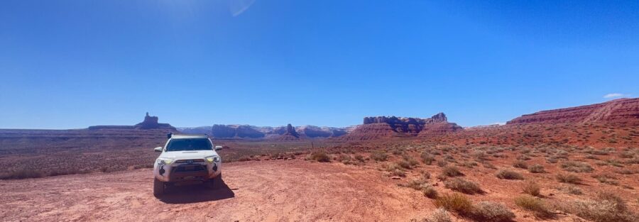
Think of Valley of the Gods as Monument Valley’s wilder, quieter sibling. Same towering sandstone buttes. Same cinematic desert light. But no entrance fee, no crowds, and no rules saying you can’t camp between the formations. This 16.3-mile dirt loop winds through Bears Ears National Monument near Mexican Hat, Utah, and it feels like someone forgot to tell the rest of the world it exists.
Valley of the Gods is close to perfect. No crowds to navigate. No variables to manage. Just you, the road, and formations that have been standing here for millions of years. That kind of permanence is calming in a way that’s hard to put into words.
Quick Facts
Route | Valley of the Gods Road |
Location | Bears Ears National Monument, near Mexican Hat, Utah |
Coordinates (East) | |
Coordinates (West) | |
Distance | 16.3 miles (loop) |
Difficulty | Easy (dirt road, high clearance recommended) |
Time | 1.5 to 3 hours |
Dogs Allowed | Yes (leashed) |
Fee | Free |
AllTrails |
How to Get There
Valley of the Gods Road has two entrances and you can drive it from either direction. The western entrance is off US-163, about 10 miles north of Mexican Hat. The eastern entrance is off UT-261, about 15 miles south of the UT-95 junction near Natural Bridges.
Both entrances are marked with small signs. Easy to spot if you’re looking. Easy to miss if you’re not. The road is unpaved but well-maintained in dry conditions. After heavy rain, the clay surface turns to mud fast and sections can become impassable. Check weather before heading out.
If you’re coming from Bluff, the eastern entrance is the quicker approach. If you’re connecting from Monument Valley or Mexican Hat, the western entrance drops you right in.
Parking Information
There’s no formal parking lot. The road has pullouts and wide shoulders at various points along the loop. Pull off fully to let other vehicles pass. The road is narrow in spots.
No entrance fee. No kiosk. No facilities. This is BLM land. You park where you stop. Bring everything you need and take everything with you when you leave.
Cell Service and Navigation
Cell service is nonexistent on Valley of the Gods Road. Don’t count on any signal for the entire 16.3-mile loop. Download your maps, route, and any AllTrails data before you leave Mexican Hat or Bluff.
The road is a single loop with no real junctions or side roads to get lost on. But if you’re connecting to Moki Dugway, Muley Point, or Goosenecks after, have those directions saved offline.
What to Expect on Valley of the Gods Road
The Road
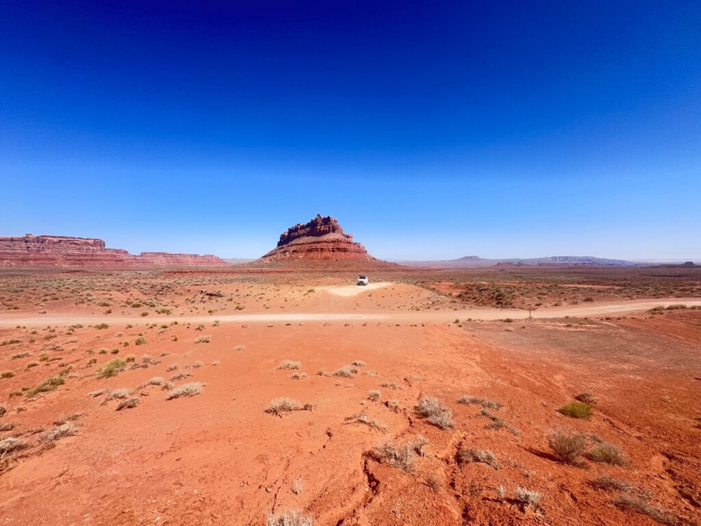
This is a dirt road, not a highway. Rocky sections, shallow dips, washboard stretches, and a few spots where the road narrows between formations. High-clearance vehicles are recommended. A 4Runner, Tacoma, Jeep, or any truck handles it without issue. Sedans can make it in dry conditions if you go slow, but you’ll feel every rut.
Four-wheel drive is not necessary in dry weather. After rain, skip it entirely. The clay surface becomes a slick, sticky mess that will strand anything without serious traction. Check conditions locally before committing.
Plan 1.5 to 3 hours depending on how many times you stop. You’ll stop a lot.
The Formations
The buttes and monoliths along Valley of the Gods Road are smaller than Monument Valley’s but no less impressive up close. Lady in the Bathtub, Setting Hen Butte, Castle Butte, Rooster Butte. The names are quirky. The formations are massive. Each turn reveals a new composition, and the shapes change as the light shifts.
The valley floor is wide and flat between formations. Red sand, prickly pear, and sagebrush. In spring, wildflowers fill the gaps between the rocks. The sense of space is enormous. You can see for miles in every direction, and most of the time there’s nobody else in sight.
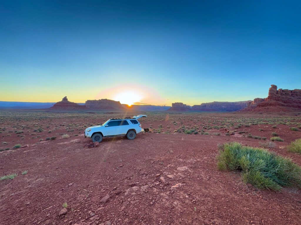
The Light
Sunset is the main event. The buttes glow deep orange and red in the last hour of light, with shadows stretching across the valley floor. It’s the reason photographers come here. Sunrise is equally good but colder and quieter.
Midday light is harsh and flat. If you’re here for photos, time your drive around golden hour. If you’re camping on the road, you get both sunrise and sunset without driving anywhere.
Drive Difficulty and Length
Valley of the Gods Road covers 16.3 miles on a dirt loop. It’s rated easy for off-road driving in dry conditions. The surface is uneven with rocky patches, shallow dips, and washboard sections, but nothing technical.
High clearance is recommended. Four-wheel drive is not necessary in dry weather. After rain, the road can be impassable. The clay soil turns to thick mud that grabs tires and doesn’t let go.
The road is narrow in places. Pull over fully when passing other vehicles. Drive slowly around blind curves near the larger formations.

Dog Friendly?
Yes. Dogs are welcome on the road and at pullouts. Keep them leashed and close when outside the vehicle. The desert floor is rough with sharp rocks, thorny plants, and hot sand in summer. Bring extra water for your dog. There are zero water sources along the route.
What to Bring
Water. At least two liters per person, more if camping. There is no water anywhere on this road. Bring snacks or a cooler. If you’re making a full day of the Four Corners area, stock up in Bluff or Mexican Hat before heading out.
A full tank of gas. There are no services between Mexican Hat and Bluff on this route. If you’re connecting to Moki Dugway or Muley Point after, you’ll want a full tank before you start.
Camera gear is a given. A telephoto lens compresses the buttes beautifully. Wide-angle captures the valley’s scale. A polarizing filter cuts haze and deepens the desert sky. Bring a lens cloth. Dust coats everything.
If you’re camping, bring all your own supplies. No facilities, no fire rings, no trash service. Pack it in, pack it out.
Best Time to Drive Valley of the Gods Road
Spring (March through May) and fall (September through November) are ideal. Mild temps. Clear skies. Good light. Spring brings wildflowers to the valley floor. Fall brings cooler air and deeper color in the rock.
Summer gets brutal. Temps push into the 90s with zero shade on the road. If you visit in summer, drive early morning or late afternoon. Midday is miserable and the light is flat.
Winter is quieter. Cooler temps, fewer visitors. But rain or snow can shut the road down fast. The clay surface doesn’t drain well and takes days to dry. Check conditions before you go.
For photography, plan your drive to end at sunset. The last 30 minutes of light on these formations is some of the best in the state.
Rules and Regulations
Valley of the Gods Road is managed by the Bureau of Land Management within Bears Ears National Monument. Standard BLM rules apply.
Stay on the designated road. Do not drive off-road. The desert surface is fragile and tire tracks last for years. Dispersed camping is permitted at designated pullouts along the road. No fees, no reservations.
Pack out all trash. No established fire rings, so check current fire restrictions before lighting anything. Drones require a special use permit. Commercial photography requires BLM approval.
Respect the land. This is part of Bears Ears, a landscape with deep cultural and historical significance. Leave it cleaner than you found it.
Where to Stay Near Valley of the Gods
Mexican Hat, at the southern end of the loop, has a handful of motels and one of the most recognizable rock formations in Utah sitting right on the highway. Bluff, about 20 miles east, has more character, better food, and a few solid lodging options. For points travelers, check available Marriott Bonvoy properties, IHG Rewards hotels, and Hilton Honors options in the broader Four Corners area.
Camping Nearby
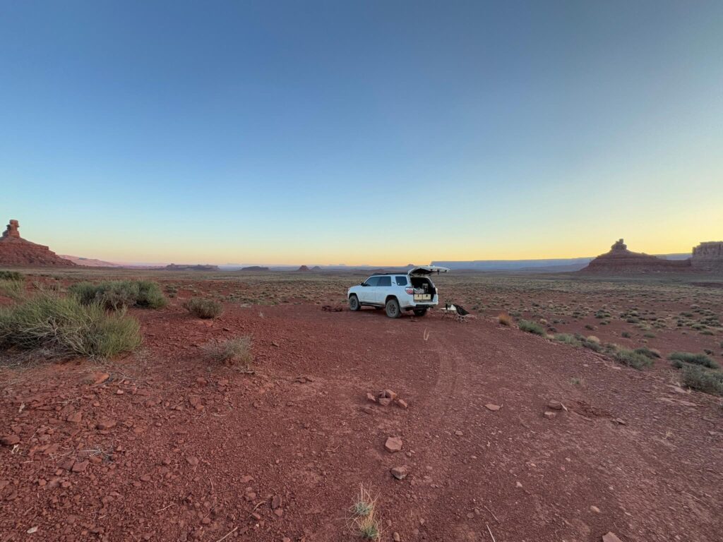
Valley of the Gods Road itself is the camping. Dispersed camping is allowed at pullouts along the loop. No fee. No facilities. No reservations. Just pick a spot between the buttes, park, and set up. Waking up surrounded by sandstone towers with nobody else in sight is one of the best free camping experiences in the West.
Muley Point is another option. Dispersed camping right on the rim overlooking the San Juan River, Monument Valley, and Valley of the Gods itself. No fee. No facilities. Access is off UT-261 just before the Moki Dugway descent.
Recapture Reservoir near Blanding is a good fallback if you want water access.
Nearby Adventures
Valley of the Gods sits at the crossroads of some of the best adventure in southeast Utah.
Goosenecks State Park is about 10 miles from the western entrance. One of the most photographed river bends in the state. Quick stop, massive views of the San Juan River carving 1,000 feet below the rim.
The Moki Dugway is right at the eastern entrance of Valley of the Gods. A gravel switchback carved into a sheer cliff face that climbs 1,100 feet to the top of Cedar Mesa. One of the most dramatic stretches of road in Utah.
The Monument Valley Scenic Drive is about 20 miles south. A 13.4-mile dirt loop through the iconic buttes and mesas of Navajo Tribal Park.
House on Fire in Mule Canyon is one of the most photographed ruins in Utah. Easy 1.9-mile hike with 72 feet of gain. About 30 miles north.
Butler Wash Interpretive Trail is a 0.9-mile walk to ancient cliff dwellings in Bears Ears. Quick stop on the way north toward Blanding.
The Natural Bridges Loop covers 8.1 miles with 1,082 feet of gain. Three massive natural bridges, canyon bottom solitude, and Ancestral Puebloan ruins.
For food, Twin Rocks Café in Bluff does excellent Navajo tacos and fry bread. Comb Ridge Eat and Drink, also in Bluff, serves farm-to-table food with red rock views.
The Bluff Fort Historic Site is worth a stop if you’re interested in pioneer history. Restored cabins and exhibits about the settlers who crossed the San Juan River in the 1880s.
Plan This Drive
Ready to hit the road? Download the route map, check current conditions, and log your drive on AllTrails.
AllTrails gives you offline maps, GPS tracking, and real-time trail conditions. It’s the first app I open before every adventure.
Chase the Quiet
Valley of the Gods gave me one of those evenings that sticks. Estes parked between two buttes. Camp chair out. Coffee cooling in my hand. The sun dropping behind the formations, painting everything in shades of fire. No other headlights. No engine noise. Just the wind and the rock and the slow realization that I didn’t need to be anywhere else.
Support the Adventure
To make your walls less boring, check out my photography portfolio and bring a piece of the wild and my story into your home.
If you’d like to fuel future adventures, you can donate a coffee on Ko-Fi. Every cup keeps me chasing sunrises and stories.
When you shop using my affiliate links, every click helps support this blog at no extra cost to you. It’s a small way to keep Unicorn Adventure alive and kicking while I keep exploring.
Subscribe to my mailing list for future updates, new stories, and behind-the-scenes adventures.
Stay connected with me on Instagram and Facebook for more photos and daily inspiration.
Thanks for being part of the journey, Unicorn Squadron!

Theo Maynard is a landscape photographer and adventure blogger based in Salt Lake City. He chases remote desert and mountain light across the American West, documents it all solo, and shares the journey through Unicorn Adventure. He’s on the autism spectrum, and that’s not a footnote, it’s the whole story. He creates to inspire others to get outside, chase what lights them up, and live their best possible life. Unapologetically himself.