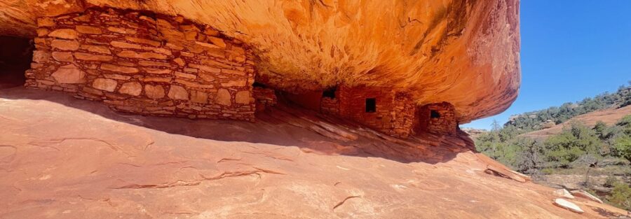
You’ve probably seen this ruin before you ever knew its name. House on Fire is one of the most photographed archaeological sites in Utah, and for good reason. When mid-morning sunlight hits the sandstone overhang just right, the rock above the ancient dwelling appears to erupt in flames. Orange. Red. Rippling. It looks like the whole structure is burning. It’s not. It’s just light and stone doing something extraordinary.
The hike to get there is short, flat, and easy. The ruin itself is tucked about a mile into Mule Canyon in Bears Ears National Monument, just west of Blanding. No technical skills required. No permit lottery. Just a sandy wash, some juniper shade, and one of the most surreal moments you’ll have on any trail in the Southwest.
Quick Facts
Trail Name | House on Fire |
Location | Bears Ears National Monument, Mule Canyon, near Blanding, Utah |
Coordinates | |
Distance | 1.9 miles (out and back) |
Elevation Gain | ~72 feet |
Difficulty | Easy |
Time | 45 minutes to 1.5 hours |
Dogs Allowed | Yes (leashed) |
Fee | $5 day-use fee per vehicle (self-service kiosk) |
AllTrails |
How to Get There
From Blanding, take UT-95 west for approximately 19 miles. Watch for the sign marking the Kane Gulch Ranger Station on the south side of the highway. Shortly after, turn left onto County Road 263, also known as Mule Canyon Road. Follow the dirt road for about a mile to the trailhead parking area.
The road is unpaved but generally passable for most vehicles in dry weather. After heavy rain, it can get muddy and rutted. Check local conditions before heading out. If you’re coming from the west, the turnoff is about 20 miles east of Natural Bridges National Monument.
Parking Information
The trailhead lot is small. Maybe a dozen vehicles, tops. There’s a $5 day-use fee per vehicle, payable at a self-service kiosk at the trailhead. Bring cash or a check. No restrooms at the trailhead, so plan your stops in Blanding before you leave town.
During peak season (spring and fall weekends), the lot fills early. Aim to arrive before 9 AM if you want a spot and the best light.
Cell Service and Navigation
Cell service is unreliable to nonexistent in Mule Canyon and along most of UT-95 between Blanding and Natural Bridges. Don’t count on pulling up a map at the trailhead. Download your AllTrails map, GPS route, or topo before you leave Blanding. The canyon bottom has no signal at all.
Navigation on the trail itself is straightforward. You follow the wash. But having offline maps loaded is standard practice for anything on Cedar Mesa.
What to Expect on the House on Fire Trail
The Canyon Walk
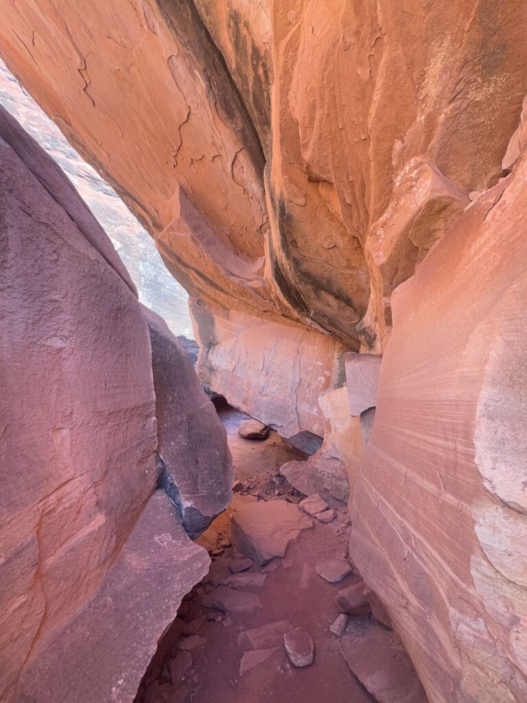
The trail follows the dry bed of Mule Canyon. Sandy wash. Juniper and pinon pine on both sides. Red rock walls rising above you. It’s flat, easy, and quiet. The path is well-worn but not formally maintained. You’re walking through a wash, so expect some sand, loose rock, and the occasional scramble over a low pour-off.
Keep your eyes on the canyon walls as you walk. There are petroglyphs and smaller ruins scattered along the route before you reach the main site. These are easy to miss if you’re locked on the trail ahead. Slow down. Look up.
The Ruin
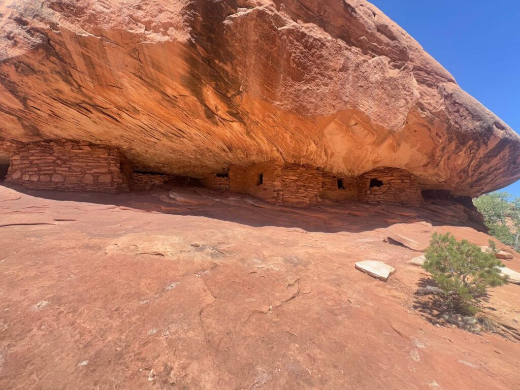
House on Fire sits about a mile into the canyon on the left (south) side. It’s a small, well-preserved Ancestral Puebloan dwelling tucked beneath a sandstone overhang. The structure itself is modest. A few stone walls. A granary. What makes it iconic is the rock above it.
The overhang has been streaked and sculpted by centuries of water, leaving wavy, layered patterns in the sandstone. When sunlight hits those patterns between roughly 10 AM and noon, the rock appears to glow like flames rippling above the ruin. The effect is striking and photographs like nothing else in the state.
The best light is mid-morning. Earlier and the sun hasn’t reached the alcove. Later and the angle flattens out. If photography is your goal, time your arrival for around 10 AM and give yourself at least 30 minutes at the site.
Trail Difficulty and Length
House on Fire covers 1.9 miles round trip with about 72 feet of elevation gain. It’s flat, easy, and accessible for families, beginners, and anyone who just wants a short walk with a big payoff. The sandy terrain can be uneven in spots, but there’s nothing technical about this hike.
Allow 45 minutes to an hour and a half, depending on how long you spend at the ruins and how many petroglyphs you stop to photograph along the way.
Dog Friendly?
Yes. Dogs are allowed on the trail but must be kept on a leash at all times. The sandy wash gets scorching hot in summer, so bring extra water for your dog and consider protective booties. Pack out all waste. There are no trash facilities on the trail.
Keep dogs away from the ruins and any rock art. These are fragile, irreplaceable sites.
What to Bring
Bring at least a liter of water per person, more in summer. There’s no water on the trail and no shade for most of the walk. Wear sturdy shoes or hiking sandals with grip. The wash surface is sandy with some slickrock sections. Sun protection is mandatory: hat, sunscreen, sunglasses.
If you’re here for the photo, bring a wide-angle lens and a tripod if you have one. The ruin sits in a recessed alcove, so you’ll be shooting up and close. A polarizing filter helps cut glare on the sandstone.
Best Time to Hike House on Fire
Spring (March through May) and fall (September through November) are the best seasons. Mild temps. Good light. Manageable crowds. The desert wildflowers in spring add color to an already photogenic canyon.
Summer gets brutal. Temps push into the 90s with little shade along the trail. If you visit in summer, hit the trail early. You want to be at the ruin by 10 AM for the best light anyway, so an early start works double duty.
Winter is quiet. Cooler temperatures and fewer visitors. Be prepared for occasional snow or icy patches in the wash. The fire effect still works in winter if the sun cooperates, but the angle is lower and less consistent.
For the fire effect specifically, plan to be at the ruin between 10 AM and noon. The higher the sun, the more dramatic the glow. Overcast days kill it.
Rules and Regulations
House on Fire sits on federal land managed by the Bureau of Land Management within Bears Ears National Monument. Leave No Trace rules apply.
Do not touch, climb on, or lean against the ruins. The structures are extremely fragile and irreplaceable. Do not disturb petroglyphs or collect artifacts. It’s illegal and it destroys the historical record for everyone who comes after you.
Drones are prohibited. Fires and camping are not allowed along the trail or at the ruin site. Stay on the main wash path and respect the cultural significance of the site.
Where to Stay Near House on Fire
Blanding is the closest town, about 30 minutes east. Motels and a few restaurants. Functional, not fancy. Bluff, about 40 miles south, has more character and better food. Mexican Hat is another option if you’re connecting to Monument Valley or Valley of the Gods. For points travelers, check available Marriott Bonvoy properties, IHG Rewards hotels, and Hilton Honors options in the broader Four Corners area.
Camping Nearby
Muley Point is the standout. Dispersed camping right on the rim with massive views of the San Juan River, Monument Valley, and Valley of the Gods. No fee. No facilities. Just you and the edge of the world.
Valley of the Gods Road has several dispersed pull-offs for camping. Free, no reservations, and you wake up surrounded by sandstone towers. Recapture Reservoir near Blanding is another option if you want water access.
There’s also dispersed camping along the Painted Desert Rim Drive if you’re heading further into the backcountry. All of these are BLM land, so standard dispersed camping rules apply: pack out everything, no fires in restricted areas, and leave it better than you found it.
Nearby Adventures
If you’re already in Mule Canyon, you’re sitting in the middle of some of the best ruin hunting in the Southwest. Don’t leave without exploring more.
Lower Mule Canyon continues past House on Fire with more ruins tucked into the canyon walls further downstream. It’s the same easy terrain with more history to find.
Butler Wash Interpretive Trail is a 0.9-mile hike with 108 feet of gain that leads to a viewpoint overlooking well-preserved Ancestral Puebloan cliff dwellings. Easy, quick, and just 15 minutes from Blanding.
Monarch Cave via Comb Ridge covers 1.6 miles with 127 feet of gain. Some of the most impressive ruins in the area.
The Natural Bridges Loop is 8.1 miles with 1,082 feet of gain. Three massive natural bridges, ancient ruins, and canyon bottom solitude. One of the best hikes in southern Utah.
The Moki Dugway is one of the most dramatic stretches of road in Utah. A gravel switchback carved into a sheer cliff face that drops 1,100 feet. Add it to the list.
For a cultural stop, the Edge of the Cedars State Park Museum in Blanding has pottery, tools, and a well-preserved kiva from the Ancestral Puebloan period. Small museum, excellent collection.
Plan This Hike
Ready to hit the trail? Download the trail map, check current conditions, and log your hike on AllTrails.
AllTrails gives you offline maps, GPS tracking, and real-time trail conditions. It’s the first app I open before every hike.
Chase the Quiet
House on Fire gave me one of those moments where the camera almost felt beside the point. Almost. I still shot it. But standing in that wash, alone, watching light turn stone into something that looked alive, I understood why people have been drawn to this canyon for centuries. Not because it’s easy to get to. Because it’s impossible to forget.
Support the Adventure
To make your walls less boring, check out my photography portfolio and bring a piece of the wild and my story into your home.
If you’d like to fuel future adventures, you can donate a coffee on Ko-Fi. Every cup keeps me chasing sunrises and stories.
When you shop using my affiliate links, every click helps support this blog at no extra cost to you. It’s a small way to keep Unicorn Adventure alive and kicking while I keep exploring.
Subscribe to my mailing list for future updates, new stories, and behind-the-scenes adventures.
Stay connected with me on Instagram and Facebook for more photos and daily inspiration.
Thanks for being part of the journey, Unicorn Squadron!

Theo Maynard is a landscape photographer and adventure blogger based in Salt Lake City. He chases remote desert and mountain light across the American West, documents it all solo, and shares the journey through Unicorn Adventure. He’s on the autism spectrum, and that’s not a footnote, it’s the whole story. He creates to inspire others to get outside, chase what lights them up, and live their best possible life. Unapologetically himself.