The first mile inside Arches National Park and you’re already in one of the best spots in it.
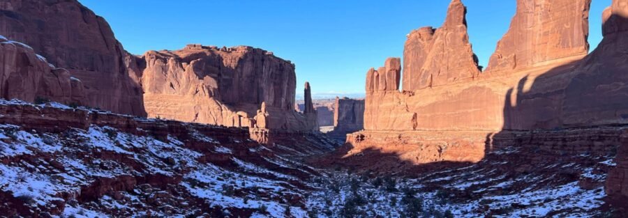
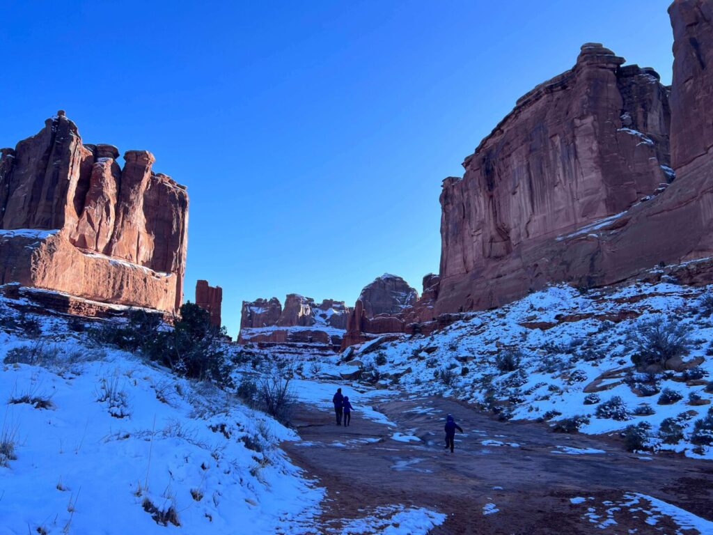
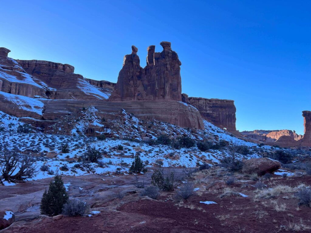
Park Avenue Trail starts at the first major viewpoint inside the park entrance, about 2.5 miles up the main road from the gate. The trail drops into a canyon flanked by sheer sandstone walls that rise 300 feet on both sides. The formations lining the route, including the Courthouse Towers, the Three Gossips, and The Organ, are among the most recognizable rock shapes in the park. The trail is 1 mile one way, easy terrain on a flat sandy track, and either an out-and-back or a one-way shuttle hike to the Courthouse Towers pullout at the far end. I’ve walked it at different times of day on multiple Moab trips. Morning light on the east-facing walls is the best of them. The canyon goes quiet in a way that larger, more crowded sections of Arches rarely do.
Here’s what you need to hike Park Avenue Trail.
Quick Facts
|
Trail Name |
Park Avenue Trail |
|
Location |
Arches National Park, near Moab, Utah |
|
Coordinates |
|
|
Distance |
2.0 miles round trip (or 1.0 mile one-way with shuttle) |
|
Elevation Gain |
300 feet |
|
Difficulty |
Easy |
|
Time |
1-1.5 hours |
|
Dogs Allowed |
No (no pets on Arches trails) |
|
Fee |
$30/vehicle or America the Beautiful Pass |
|
AllTrails |
How to Get There
Arches National Park is 5 miles north of Moab on US-191. From Moab, drive north on US-191 and turn right at the signed park entrance. A $30 per vehicle entrance fee applies. The America the Beautiful Annual Pass covers it. Follow the main park road approximately 2.5 miles from the entrance station to the Park Avenue Viewpoint on the left side of the road. The trailhead is at the viewpoint. The Courthouse Towers pullout, the other end of the one-way shuttle option, is a further 1 mile down the main road.
Parking Information
The Park Avenue Viewpoint has a moderate-sized parking lot that fills fast from mid-morning on spring and fall weekends. Arrive before 8 a.m. to guarantee a spot. If the lot is full, the Courthouse Towers pullout further down the main road has additional parking. No restrooms at the Park Avenue Viewpoint specifically, the park entrance station area has facilities before you drive in. Time reservations may be required for peak season entry. Check recreation.gov for current timed entry requirements before your visit.
Cell Service and Navigation
Cell service in Arches National Park is unreliable. Download your trail map offline through AllTrails before leaving Moab. The Park Avenue Trail is well-marked and the canyon terrain is straightforward to navigate, but having a map confirms your turnaround point for the out-and-back option and the shuttle pickup location if you’re doing one-way. Check the NPS website before visiting for any current timed entry reservation requirements, road closures, or fire restrictions.
What to Expect on Park Avenue Trail
The Canyon
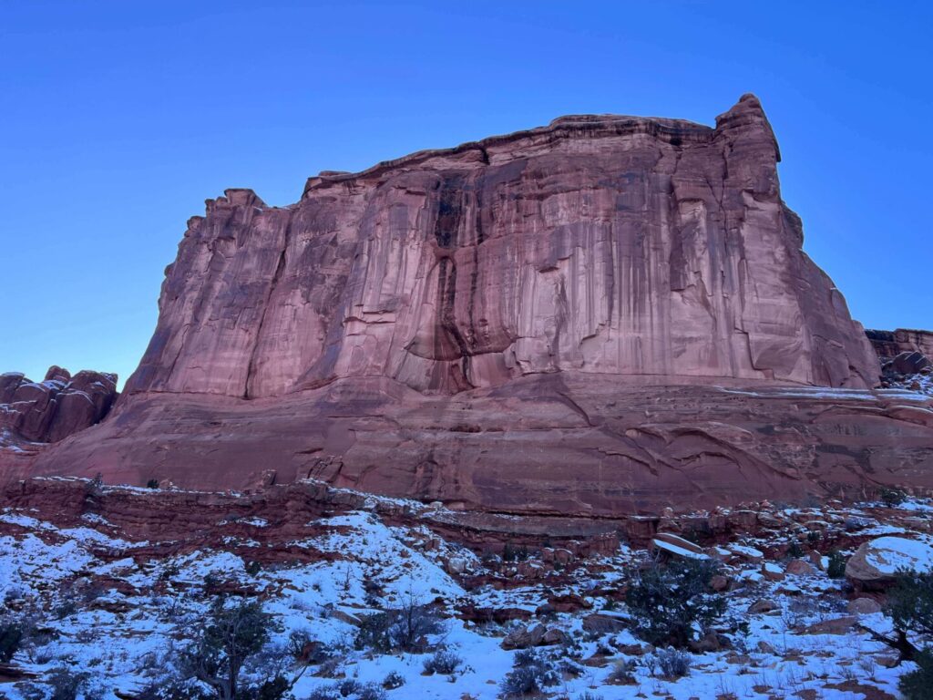
The trail drops from the viewpoint into the canyon immediately. Sandstone walls rise 300 feet on both sides, smooth and banded in the layered reds and tans of the Entrada sandstone formation that defines Arches. The canyon creates its own shade in the morning hours and is noticeably cooler than the open desert above. The flat sandy trail floor makes the walking easy. The formations visible from the trail are the draw: Three Gossips is three distinct tower formations that read as human figures at the right angle. The Organ is a massive buttress at the far end of the canyon. Courthouse Towers frames the whole view at the turnaround point or the shuttle exit.
Shuttle Option
The trail can be hiked one-way from the Park Avenue Viewpoint down to the Courthouse Towers pullout, which eliminates the 300-foot return climb. This requires leaving a vehicle at each end or arranging a shuttle. The Courthouse Towers pullout is about 1 mile further down the main park road from the Park Avenue Viewpoint. Most visitors do the out-and-back. The one-way option is worth doing if you have two vehicles or a willing driver.
Trail Difficulty and Length
Park Avenue Trail is 2.0 miles round trip with 300 feet of elevation gain (loss on the way in, gain on the return). Rated easy. The terrain is flat sandy track with occasional uneven sections. The return adds the 300-foot climb back to the viewpoint, which makes the out-and-back slightly more demanding than the one-way option suggests. For fit hikers this is a comfortable 1 to 1.5-hour outing. For families with young children or visitors not accustomed to desert hiking, budget 2 hours and watch the heat in warmer months.
Dog Friendly?
No. Pets are not permitted on any trails in Arches National Park. Dogs are allowed in parking areas, campgrounds, and along paved roads only, on leash. If you’re traveling with a dog, plan to leave them secured in a vehicle with ventilation or arrange alternative care, desert heat in a car, even with windows cracked, is dangerous. Nearby Moab has dog-friendly trails outside the park, including Corona Arch.
What to Bring
At least 1.5 liters of water per person. Even on an easy 2-mile trail in desert heat, the sun exposure drains you faster than the distance suggests. Sunscreen, a hat, and sunglasses for the exposed viewpoint and canyon entrance. Trail shoes or hiking shoes with grip for the occasional uneven rocky sections. A camera with a wide-angle lens for the canyon walls and formations. The light on the east-facing walls at sunrise is the strongest photography window. A telephoto helps isolate the Three Gossips and The Organ from a distance.
Best Time to Hike Park Avenue Trail
Spring (March through May) and fall (September through November) are the best windows. Temperatures are comfortable and the park is busy but manageable. Summer exceeds 100°F regularly and the canyon, while shaded in the morning, becomes an oven by midday. Start before 7 a.m. in summer. Winter brings cooler temperatures and far fewer visitors. Snow is possible and ice on the rocky sections requires attention, but winter Arches is legitimately beautiful when conditions cooperate.
For photography, the first light of sunrise on the sandstone walls is the best window on this trail. The east-facing canyon walls catch the warm morning light before it moves overhead. The Three Gossips read best in the first hour of light when the low angle creates strong shadow definition between the tower formations. A wide-angle lens from the canyon floor looking up captures the full wall height. Midday direct sun washes out the sandstone color and blows out the sky in the same frame.
Rules and Regulations
Arches National Park is managed by the NPS. A $30 per vehicle entrance fee applies, valid for 7 days. Timed entry reservations may be required during peak season, check recreation.gov before your visit. Stay on the designated trail at all times. The biological soil crust surrounding the trail is a living organism that takes decades to recover from foot damage. Stepping off trail is prohibited and causes lasting harm to the desert ecosystem. No pets on trails. Leave No Trace fully. The park visitor center near the entrance has current trail conditions and any emergency closures before you drive in.
Where to Stay Near Moab
Moab has full lodging inventory within 5 miles of the park entrance. For hotel points check Marriott Bonvoy, IHG Rewards, and Hilton Honors. Staying in Moab puts you 5 minutes from the park entrance and gives you access to the full range of restaurants, outfitters, and amenities in one of Utah’s best outdoor basecamp towns.
Camping Nearby
Devils Garden Campground inside Arches National Park is one of the most well-positioned national park campgrounds in Utah, reservable through recreation.gov and typically booked months in advance for spring and fall. Outside the park, the Moab area has multiple private campgrounds and BLM dispersed camping options along Kane Creek Road and the Colorado River corridor.
Nearby Adventures
Arches National Park has more trail objectives within a short drive of Park Avenue. Double Arch Trail is a 0.5-mile round trip to two connected arches and the most accessible arch experience in the park. Balanced Rock is a short roadside walk to one of the park’s most photographed formations. Delicate Arch Trail (3.2 mi / 480 ft) is the park’s signature hike and requires more commitment but delivers the best-known arch view in Utah. Double O Arch Trail at the far end of the park road extends to Landscape Arch and multiple additional arches for a longer day.
Moab beyond the park has world-class mountain biking on Slickrock and Porcupine Rim, jeep touring through the Moab Rim and Hell’s Revenge OHV areas, and river access on the Colorado for paddling and floating. Corona Arch on BLM land 10 miles west of Moab is the dog-friendly arch alternative. Dead Horse Point State Park, about 30 minutes from Moab, delivers one of the best canyon overlooks in the Colorado Plateau.
For a broader Utah desert circuit, Moki Dugway and the Monument Valley / Bears Ears area are accessible from Moab and worth building into a multi-day canyon country trip.
Plan This Hike
AllTrails has Park Avenue Trail with a downloadable map and recent user conditions. Check current reports for timed entry requirements and parking availability on peak season weekends before you drive to the park. View on AllTrails.
AllTrails Pro is worth it for an Arches visit where you’re planning multiple trails in one day. Download maps for Park Avenue, Delicate Arch, and Devils Garden before entering the park.
Chase the Quiet
Park Avenue is the first real trail inside Arches and it earns its reputation as the opener. The canyon walls hit differently at that scale when you’re standing in them rather than photographing them from the viewpoint above. It takes about five minutes for the park to start doing what Arches does. The formations come into focus, the scale registers, and whatever was in your head before you left the car gets quieter. That’s a good way to start a day in the park.
Support the Adventure
To make your walls less boring, check out my photography portfolio and bring a piece of the wild and my story into your home.
If you’d like to fuel future adventures, you can donate a coffee on Ko-Fi. Every cup keeps me chasing sunrises and stories.
When you shop using my affiliate links, every click helps support this blog at no extra cost to you. It’s a small way to keep Unicorn Adventure alive and kicking while I keep exploring.
Subscribe to my mailing list for future updates, new stories, and behind-the-scenes adventures.
Stay connected with me on Instagram and Facebook for more photos and daily inspiration.
Thanks for being part of the journey, Unicorn Squadron!

Theo Maynard is a landscape photographer and adventure blogger based in Salt Lake City. He chases remote desert and mountain light across the American West, documents it all solo, and shares the journey through Unicorn Adventure. He’s on the autism spectrum, and that’s not a footnote, it’s the whole story. He creates to inspire others to get outside, chase what lights them up, and live their best possible life. Unapologetically himself.