Devils Garden is where Arches National Park earns its name. Not one arch. Not two. A whole corridor of them stacked into 7-plus miles of trail options with the terrain getting progressively wilder the farther you push from the parking lot. Double O Arch Trail takes you to the back end of that corridor, past Landscape Arch, through sandstone fins, and eventually to a formation where a large arch and a smaller one share the same wall of rock at the same time. That’s the Double O.
This guide covers the Double O Arch Trail from the Devils Garden trailhead: how to get there, what the trail actually involves, and everything you need to plan the hike.
Quick Facts
|
Trail Name |
Double O Arch Trail (Devils Garden) |
|
Location |
Arches National Park, near Moab, Utah |
|
Coordinates |
|
|
Distance |
4.2 miles roundtrip (out-and-back to Double O) |
|
Elevation Gain |
480 feet |
|
Difficulty |
Moderate |
|
Time |
2-3 hours |
|
Dogs Allowed |
No |
|
Fee |
$35 per vehicle (America the Beautiful Pass accepted) |
|
AllTrails |
How to Get There
Arches National Park sits 5 miles north of Moab on US-191. Enter the park at the main entrance and follow the Arches Scenic Drive north for approximately 18 miles to the Devils Garden parking area at the end of the road. The trailhead is at the far end of the parking lot. The Devils Garden area is the northernmost developed area of the park and the drive in gives you most of Arches’ greatest hits along the way, including Balanced Rock, the Windows, and views down into the Salt Valley.
From Salt Lake City, plan about 4 hours: south on I-15, east on US-6, and south on US-191 into Moab. From Grand Junction, Colorado, it’s roughly an hour west. If you’re driving the scenic route from anywhere in southern Utah, every road into Moab rewards the effort.
Timed entry reservations are required during peak season, typically April through October. Reserve your entry window at recreation.gov before arriving. This is not optional during busy periods. The park hits capacity before 9 a.m. on spring and fall weekends with regularity.
Parking Information
The Devils Garden parking lot is the largest in Arches and still fills up fast. Spring and fall mornings see full lots by 8 or 9 a.m. Arrive early or align your timed entry reservation with an early window. There’s no overflow lot at the end of the road, so if the main lot is full, you wait or return later.
Restrooms are available at the trailhead. Water is available at the parking area as well, though you should fill your bottles before leaving Moab rather than relying on trailhead sources. The trail has no water beyond the parking lot.
Cell Service and Navigation
Cell coverage deteriorates as you drive north through the park and is unreliable at the Devils Garden trailhead. Download your AllTrails map offline in Moab before heading in. The NPS Arches app also has offline capability and is worth having.
The main trail to Landscape Arch and onward to Double O is well-marked. The primitive loop sections, if you add those, require more attention. Cairns mark the route but get knocked over or washed out. Having the GPS map on your phone as a backup is smart, especially in the fins section where the trail can be ambiguous.
What to Expect on the Double O Arch Trail
The Trail
The first mile is the easy part. The trail from the parking lot to Landscape Arch is flat, wide, and heavily trafficked. Most visitors turn around at Landscape Arch and head back. That’s fine for them. But continuing past it is where the trail shifts character entirely.
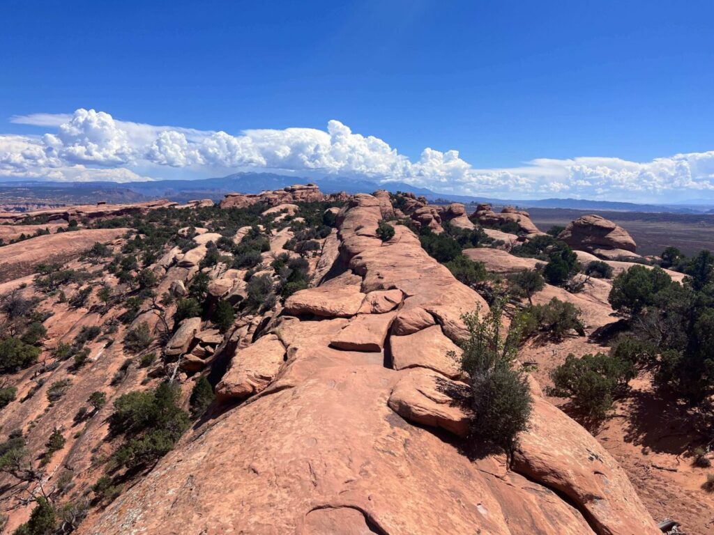
Past Landscape Arch, the trail narrows and the terrain starts working. You’ll navigate sandstone fins, which are long vertical slabs of rock with the trail running right along their spines. The exposure on either side isn’t extreme, but it requires comfortable footing and attention. For hikers who are nervous about heights, the fins section is where that shows up.
The approach to Double O involves some scrambling on slickrock and a few sections where the route is less obvious. Take your time reading the terrain ahead before committing to a line. The trail does go through, but it’s not always immediately apparent where.
The Arches
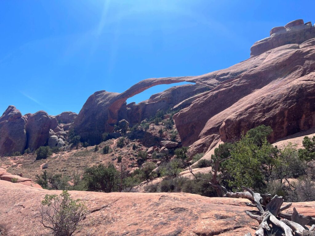
Landscape Arch appears about a mile in, spanning roughly 290 feet across a thin ribbon of rock. It’s one of the longest natural spans in the world and looks like it shouldn’t be able to hold its own weight, because honestly it barely does. Chunks have dropped from the arch in recorded history. You’re watching something in the process of becoming something else over geologic time. Worth stopping for.
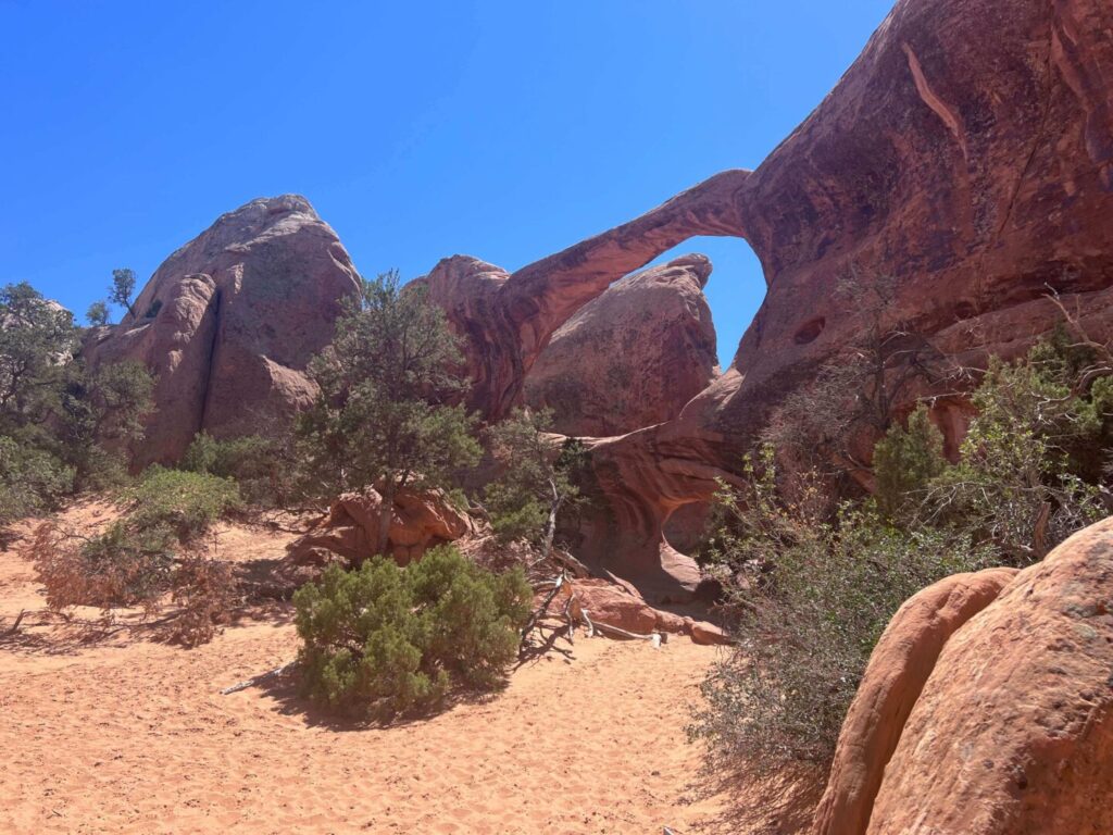
Double O Arch is the destination. The larger arch spans maybe 70 feet and sits above a smaller arch that shares the same sandstone wall, the two openings stacked vertically in the same formation. The shape is distinct and unlike anything else in the park. From below, you can walk through the lower arch and look up through both openings simultaneously. That’s the shot.
Trail Difficulty and Length
Moderate is accurate for the out-and-back to Double O. The 4.2-mile roundtrip has 480 feet of elevation gain distributed unevenly: flat to Landscape Arch, then more concentrated climbing on the fins and approach to Double O. The scrambling sections are manageable for confident hikers but require more than a casual approach.
The primitive loop option adds distance and difficulty. If you complete the full Devils Garden Primitive Loop, you’re looking at about 7.8 miles with significantly more technical terrain in the back half. That’s a full-day commitment for most hikers and demands solid navigation skills and comfort on exposed slickrock.
Trail shoes or hiking boots are the right call. Sandals are not. Budget 2-3 hours for the out-and-back to Double O at a relaxed pace with time at both arches.
Dog Friendly?
No. Arches National Park prohibits pets on all trails, including the Double O Arch Trail and the full Devils Garden area. Dogs are permitted in the parking lot, at picnic areas, and along paved roads, but must stay on leash at all times. The backcountry and any unpaved surface is off-limits for pets. For dog-friendly hiking near Moab, look to BLM land outside the park boundaries. Corona Arch Trail on BLM land 10 miles west of Moab is the solid alternative.
What to Bring
Water is the priority. Bring at least 2-3 liters per person. The trail is exposed and the parking lot water shouldn’t be your primary fill. In summer, go heavier.
Sun protection: hat, sunscreen, sunglasses. The sandstone fins section has no shade at all. Sturdy trail shoes or hiking boots for the scrambling. Trekking poles help some hikers on the slickrock sections, especially on the descent.
For photography, a wide-angle lens for both arches and a longer focal length for detail work on the fins. The light on the fins in morning and late afternoon is genuinely excellent for texture and shadow play.
Best Time to Hike Double O Arch
Spring (March through May) and fall (September through November) are the prime windows. Temperatures are manageable, the light has warmth, and the desert is at its most alive.
Summer hiking is doable but demands an early start. Be on the trail before 7 a.m. and plan to be back at the parking lot by midday. The exposed fins section becomes a heat trap by late morning on summer days. People get into real trouble in the Arches backcountry in July and August. Take the heat seriously.
Winter brings solitude and cold. The trail can ice up on north-facing sections and in shadowed spots in the fins. Microspikes or extreme caution are required on icy slickrock. The park is gorgeous in low winter light, and the lack of crowds is its own reward.
For photography, early morning is the move. The Devils Garden trailhead faces east and the light hits the arches and fins beautifully in the first two hours after sunrise. Plan to be at Double O Arch by mid-morning for direct light through both openings.
Rules and Regulations
Stay on designated trails. The cryptobiotic soil crust in the Devils Garden area is fragile and takes decades to recover from a single footprint off-trail. Walk on rock or on the established path.
Do not climb on Landscape Arch. The arch is actively eroding and has shed rock in recorded history. The NPS enforces the viewing area boundaries. Respect them.
Arches is designated as an International Dark Sky Park. If you’re visiting for night photography, minimize artificial light and be conscious of other visitors’ dark-sky experience. No drones without a permit. Pack out everything. The $35 vehicle fee or America the Beautiful Pass covers park entry.
Timed entry reservations are required during peak season. Book at recreation.gov.
Where to Stay Near Moab
Moab is your base, 18 miles south of the Devils Garden trailhead via the park road. The town has lodging across every budget range, from budget hostels to full river-view resort rooms. Red Cliffs Lodge on the Colorado River on Highway 128 offers rooms with canyon views and an easy drive toward the park entrance. For points travelers, check available Marriott Bonvoy properties in Moab, IHG Rewards hotels near Moab, and Hilton Honors options in the area. Book well ahead for spring and fall. Moab accommodation disappears fast in peak season.
Camping Nearby
Devils Garden Campground is the only developed campground inside Arches and sits right at the trailhead. This is ideal for an early start on the trail. Reservations open months in advance on recreation.gov and book out almost immediately for spring and fall dates. Plan well ahead or check for cancellations.
Outside the park, the BLM dispersed camping options around Moab cover most needs. Gemini Bridges, Porcupine Rim, and the Sandflats Recreation Area east of town are the main areas. Sandflats has facilities and is closest to town.
Nearby Adventures
Within Arches, the Windows Loop and Turret Arch Trail, Balanced Rock, and Park Avenue cluster naturally on the drive into the park. Delicate Arch is the iconic stop on the same park road. Sand Dune Arch is the short shaded slot hike worth fitting in.
Canyonlands Island in the Sky, 30 miles from Moab on UT-313, adds Mesa Arch, White Rim Overlook, and Aztec Butte to a Moab itinerary. Corona Arch on BLM land is the dog-friendly arch outside the parks.
Plan This Hike
AllTrails has the Double O Arch Trail mapped with offline GPS tracking. The fins section in particular benefits from active GPS to confirm route. Plan your hike on AllTrails and pull the offline map in Moab.
Chase the Quiet
Most of the Devils Garden trail traffic stops at Landscape Arch. The next 1.5 miles to Double O sees a fraction of that, and the primitive loop beyond it sees a fraction of that again. The arches don’t get fewer or smaller the deeper you go. The crowds do. That trade is the whole reason to push past Landscape and into the fins. The terrain works harder. The reward is bigger. The shot through both Double O openings only happens here.
Support the Adventure
To make your walls less boring, check out my photography portfolio and bring a piece of the wild and my story into your home.
If you’d like to fuel future adventures, you can donate a coffee on Ko-Fi. Every cup keeps me chasing sunrises and stories.
When you shop using my affiliate links, every click helps support this blog at no extra cost to you. It’s a small way to keep Unicorn Adventure alive and kicking while I keep exploring.
Subscribe to my mailing list for future updates, new stories, and behind-the-scenes adventures.
Stay connected with me on Instagram and Facebook for more photos and daily inspiration.
Thanks for being part of the journey, Unicorn Squadron!

Theo Maynard is a landscape photographer and adventure blogger based in Salt Lake City. He chases remote desert and mountain light across the American West, documents it all solo, and shares the journey through Unicorn Adventure. He’s on the autism spectrum, and that’s not a footnote, it’s the whole story. He creates to inspire others to get outside, chase what lights them up, and live their best possible life. Unapologetically himself.