Mesa Arch at sunrise is one of the most photographed moments in the American Southwest. Half a mile of trail to get there. Worth every inch.
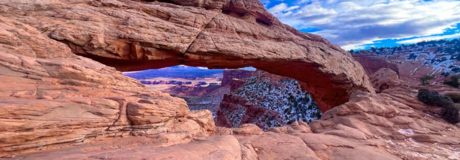
Mesa Arch sits on the rim of the Island in the Sky district in Canyonlands National Park, about 30 miles from Moab via US-191 and UT-313. The arch frames a drop into Buck Canyon below and the La Sal Mountains in the distance. At sunrise the underside of the arch catches the first light and glows amber and orange while the canyon below is still dark. The trail to get there is a 0.5-mile loop with almost no elevation gain. The experience at the arch has nothing to do with trail difficulty and everything to do with timing.
Here’s what you need to see Mesa Arch.
Quick Facts
|
Trail Name |
Mesa Arch Trail |
|
Location |
Island in the Sky District, Canyonlands National Park, near Moab, Utah |
|
Coordinates |
|
|
Distance |
0.5 miles (loop) |
|
Elevation Gain |
Under 100 feet |
|
Difficulty |
Easy |
|
Time |
30-45 minutes |
|
Dogs Allowed |
No (no pets on Canyonlands trails) |
|
Fee |
$30/vehicle or America the Beautiful Pass |
|
AllTrails |
How to Get There
From Moab, head north on US-191 for approximately 10 miles. Turn left onto UT-313 heading west toward Canyonlands National Park. Drive UT-313 about 22 miles to the park entrance. A $30 per vehicle fee applies. The America the Beautiful Annual Pass covers it. After the entrance station, continue on the main park road for about 6 miles to the signed Mesa Arch turnoff on the right. The trailhead parking lot is immediately off the road.
For sunrise photography, plan to arrive at the parking lot 45 to 60 minutes before sunrise. The light hits the arch approximately at sunrise itself, so you need positioning time before the moment arrives.
Parking Information
The Mesa Arch trailhead has a designated parking lot that is small relative to the trail’s popularity. During peak sunrise season in spring and fall it fills before first light. Arriving 60 to 90 minutes before sunrise for a photography visit is the practical minimum. For midday visits the lot still fills fast on weekend mornings from March through October. If the lot is full, the next closest pull-off is back down the main road. No restrooms at the Mesa Arch trailhead. The Island in the Sky Visitor Center, about 6 miles back toward the entrance, has facilities.

Cell Service and Navigation
Cell service in Canyonlands National Park is unreliable throughout and essentially nonexistent in the interior. Download your trail map offline before leaving Moab. The Mesa Arch loop is well-marked and 0.5 miles, navigation is not a challenge. The drive on UT-313 to the park and within the park is the section where having offline maps matters most, particularly on the pre-dawn drive for a sunrise visit. Check the NPS website for current timed entry requirements and any road closures before heading out.
What to Expect at Mesa Arch
The Trail
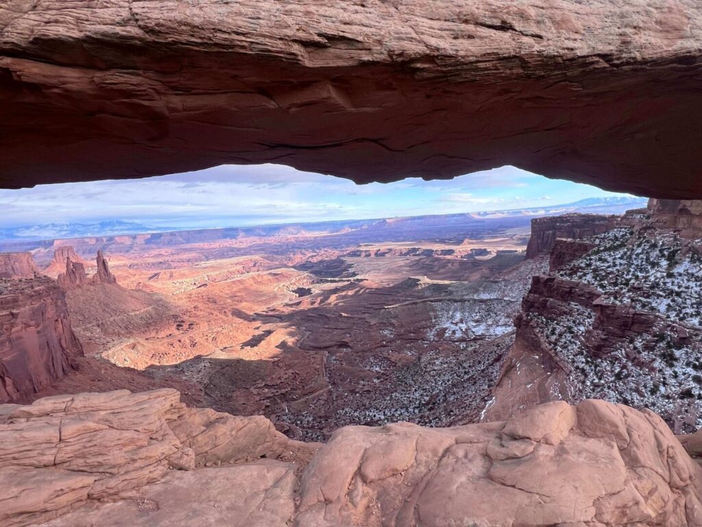
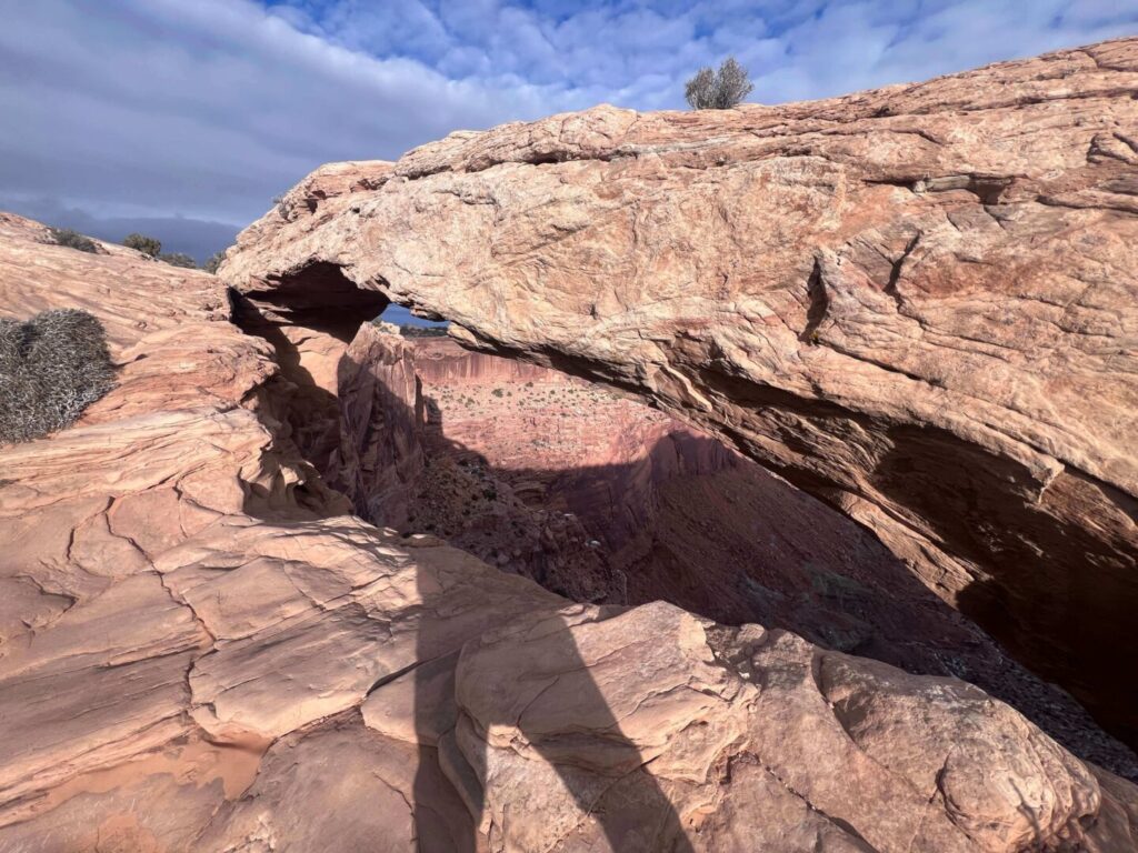
The loop starts at the parking lot and crosses open slickrock and sandy terrain through pinyon-juniper scrub to the arch. The path is well-defined and the rim becomes visible before you reach the arch. The final approach is across flat slickrock. The arch sits at the canyon edge with nothing but open space beyond it. The first view of the arch, sandstone span, Buck Canyon drop, La Sal Mountains in the distance, registers immediately regardless of the time of day.
Mesa Arch at Sunrise
The sunrise shot at Mesa Arch is one of the signature landscape photography images of the Colorado Plateau. The sun rises to the east and the first light catches the underside of the arch, reflecting orange and amber light back toward the viewer. The canyon below is still deep in shadow when the arch starts to glow. The La Sal Mountains appear in the background through the arch frame. This combination of foreground light, dark canyon, and distant mountains lasts about 15 to 20 minutes from first light to full brightness. Position yourself on the slickrock below and west of the arch for the standard shot. Arrive early enough to find your spot before the crowd.
Trail Difficulty and Length
Mesa Arch Trail is 0.5 miles on a well-maintained loop with minimal elevation change. Rated easy. Suitable for any fitness level. The canyon rim edge near the arch is unguarded and drops significantly into Buck Canyon below. Stay on the established slickrock viewing areas and don’t approach the arch edge without full attention to footing. Children should be kept within arm’s reach near the rim. Budget 30 to 45 minutes including time at the arch, longer if you’re shooting the sunrise sequence.
Dog Friendly?
No. Canyonlands National Park does not allow pets on trails, in the backcountry, or on unpaved roads. Pets are permitted in parking areas, campgrounds, and on paved roads on a 6-foot leash. If you’re traveling with a dog, plan alternative activities outside the park boundaries in Moab or the surrounding BLM land. Corona Arch is the BLM-land dog-friendly alternative.
What to Bring
For a sunrise visit: layers for the cold pre-dawn drive and the cold waiting period at the arch. The canyon rim at 5 a.m. in spring is significantly colder than Moab was when you left. A headlamp for the dark parking lot and trailhead approach. A camera, tripod, and wide-angle lens positioned below and west of the arch for the standard sunrise frame. For a daytime visit: at least 1 liter of water per person (short trail but exposed desert). Sunscreen, a hat. Trail shoes are fine, the loop is mostly flat slickrock and packed trail.
Best Time to Visit Mesa Arch
Spring (March through May) and fall (September through November) are the primary seasons for Mesa Arch photography and hiking. The sunrise timing is best in spring and fall when the sun angle aligns most favorably with the arch orientation. Summer sunrise starts very early, which is operationally challenging from Moab, and the desert heat by mid-morning makes the drive and hike uncomfortable. Winter produces the most dramatic skies and occasional snow on the surrounding mesa, but cold temperatures at the rim require preparation.
The single most important timing decision for Mesa Arch: go at sunrise or go with different expectations. The midday arch is still impressive, but it’s a different thing entirely from the lit underside at first light. If you’re making the 30-mile drive from Moab, make it for sunrise at least once.
Rules and Regulations
Mesa Arch Trail is in Canyonlands National Park, managed by the NPS. A $30 per vehicle entrance fee applies, valid for 7 days. Stay on designated trails. The biological soil crust surrounding the trail is a living organism that takes decades to recover from damage, stepping off trail is prohibited. Do not climb on Mesa Arch. The arch is fragile sandstone under constant stress and climbing causes irreversible damage. Check recreation.gov for current timed entry requirements before your visit. Timed entry may be required during peak season.
Where to Stay Near Moab
Moab is the base for Canyonlands Island in the Sky, about 30 miles east. The town has full lodging inventory. For hotel points check Marriott Bonvoy, IHG Rewards, and Hilton Honors. Red Cliffs Lodge and The Caves at Moab are both worth a look for atmosphere and proximity to the park road.
Camping Nearby
Willow Flat Campground inside the Island in the Sky district is a first-come, first-served primitive campground close to Mesa Arch, ideal for early morning positioning without the Moab drive. Reservable campgrounds in the area include those in Moab’s commercial campground corridor and the Dead Horse Point State Park campground above the Colorado River. recreation.gov handles Canyonlands backcountry permits for extended stays.
Nearby Adventures
Island in the Sky has more worth doing beyond Mesa Arch. Grand View Point Trail (1.8 mi / 107 ft) at the end of the main park road delivers the most expansive canyon view in the district. White Rim Overlook Trail gives you a 1,200-foot drop view in 1.8 miles. Aztec Butte Trail adds ancestral granaries and big mesa views. Upheaval Dome Trail is the geological mystery hike worth the extra effort.
Dead Horse Point State Park, just off UT-313 on the drive back to Moab, is one of the best overlooks in the Colorado Plateau and worth stopping for the view of the Colorado River horseshoe bend below. The park has its own trail network and a viewpoint that rivals anything in Canyonlands for the view-per-effort ratio.
Moab beyond the parks has world-class mountain biking, jeep touring, and river access. Arches National Park is 25 miles back toward Moab with Park Avenue Trail and Delicate Arch among its best hikes. For further canyon country driving, Moki Dugway and the Monument Valley / Bears Ears corridor are accessible on a longer road trip south.
Plan This Hike
AllTrails has Mesa Arch Trail with a downloadable map and recent user conditions. The most useful check for this trail is current sunrise timing, crowd reports at peak season, and any current NPS timed entry requirements. View on AllTrails.
AllTrails Pro is worth it for an Island in the Sky day where you’re visiting multiple viewpoints and trails. Download maps for Mesa Arch, Grand View Point, and Upheaval Dome before leaving the cell service corridor.
Chase the Quiet
Mesa Arch at sunrise, 20 minutes before the light hits, standing on cold slickrock in the dark watching the eastern horizon brighten: that’s the whole thing. The crowd arrives later. The light arrives on schedule. Being there before both is the only requirement. Set your alarm, drive the 30 miles, and position yourself. The arch does the rest.
Support the Adventure
To make your walls less boring, check out my photography portfolio and bring a piece of the wild and my story into your home.
If you’d like to fuel future adventures, you can donate a coffee on Ko-Fi. Every cup keeps me chasing sunrises and stories.
When you shop using my affiliate links, every click helps support this blog at no extra cost to you. It’s a small way to keep Unicorn Adventure alive and kicking while I keep exploring.
Subscribe to my mailing list for future updates, new stories, and behind-the-scenes adventures.
Stay connected with me on Instagram and Facebook for more photos and daily inspiration.
Thanks for being part of the journey, Unicorn Squadron!

Theo Maynard is a landscape photographer and adventure blogger based in Salt Lake City. He chases remote desert and mountain light across the American West, documents it all solo, and shares the journey through Unicorn Adventure. He’s on the autism spectrum, and that’s not a footnote, it’s the whole story. He creates to inspire others to get outside, chase what lights them up, and live their best possible life. Unapologetically himself.