There are hikes in the American Southwest that are about distance and hikes that are about what you find at the end. Aztec Butte Trail is the second kind. It’s 2 miles roundtrip in the Island in the Sky district of Canyonlands National Park, short enough to finish before lunch, and at the top of the butte are ancestral Puebloan granaries that have been sitting in their sandstone alcoves for somewhere between 700 and 1,000 years. You scramble up slickrock, you find them tucked into the cliff face, and you spend a few minutes thinking about the people who built them and why they chose this particular perch on this particular rock above this particular canyon system.
This guide covers Aztec Butte Trail from trailhead to granaries: directions, what to expect on the scramble, and how to build a full Canyonlands day around it.
Quick Facts
|
Trail Name |
Aztec Butte Trail |
|
Location |
Canyonlands National Park, Island in the Sky, near Moab, Utah |
|
Coordinates |
|
|
Distance |
2.0 miles roundtrip |
|
Elevation Gain |
Approx. 225 feet |
|
Difficulty |
Moderate |
|
Time |
1-2 hours |
|
Dogs Allowed |
No |
|
Fee |
$35 per vehicle (America the Beautiful Pass accepted) |
|
AllTrails |
How to Get There
From Moab, head north on US-191 for about 10 miles, then turn left onto UT-313 west toward Canyonlands National Park. Follow UT-313 for roughly 22 miles into the Island in the Sky district. After entering the park, continue on the main road for about 8 miles and watch for the signed Aztec Butte Trailhead on the right. Total drive from Moab is about 40 minutes.
From Salt Lake City, plan around 4.5 hours: south on I-15, east on US-6, south on US-191, then west on UT-313. From Grand Junction, Colorado, it’s about 1.5 hours west via I-70 and US-191.
No timed entry reservation system currently operates at Canyonlands Island in the Sky the way Arches does, but the park has moved toward a reservation system during peak season in recent years. Check nps.gov/cany before your visit to confirm current entry requirements. The $35 vehicle fee or America the Beautiful Pass covers entry.
Parking Information
The Aztec Butte Trailhead has a small dedicated parking lot. It fills quickly on spring and fall mornings, especially between 9 a.m. and noon when most day visitors are moving through the Island in the Sky corridor. Arrive early or plan your visit for late morning when some of the earliest arrivals have cleared out.
No facilities at the trailhead. The Island in the Sky Visitor Center, a few miles back toward the entrance, has restrooms and information. Stop there on the way in if needed.
Cell Service and Navigation
Cell service drops off significantly once you leave US-191 onto UT-313 and disappears almost entirely inside Canyonlands Island in the Sky. Download your navigation before leaving Moab. AllTrails has Aztec Butte mapped with offline capability. The NPS Canyonlands app is also worth pulling down.
The trail itself is well-marked with cairns on the slickrock sections. Navigation isn’t the challenge here, the scramble to the butte top is. Having the GPS map active on your phone is useful more for confirming you’re on the right butte approach than for route-finding on the lower trail.
What to Expect on the Aztec Butte Trail
The Trail
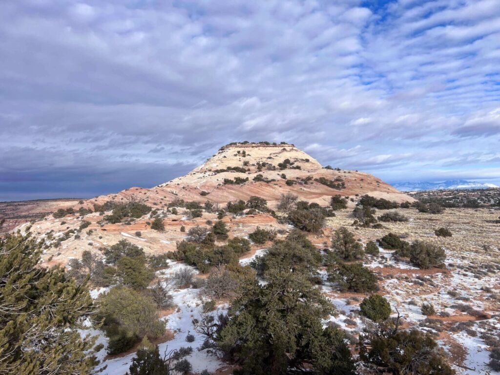
The trail starts in a sandy wash, flat and straightforward for the first portion. You’re moving through open desert with the butte rising ahead, the surrounding canyon country visible on either side. The terrain shifts from sandy wash to packed dirt to slickrock as you gain elevation, and the final approach to the butte top involves genuine scrambling over exposed sandstone.
The slickrock scramble is where the moderate rating earns itself. It’s not technical climbing, no hands-and-feet exposure, but it requires comfortable movement on angled rock and a willingness to trust your footwear. Hikers who are nervous on exposed surfaces may find the final push to the butte top the crux of the experience. Take it slow. The route goes.
Once on top, the butte opens into a flat sandstone platform with 360-degree views across the Island in the Sky mesa and down into the canyon systems on all sides. The views alone justify the scramble. Then you find the granaries.
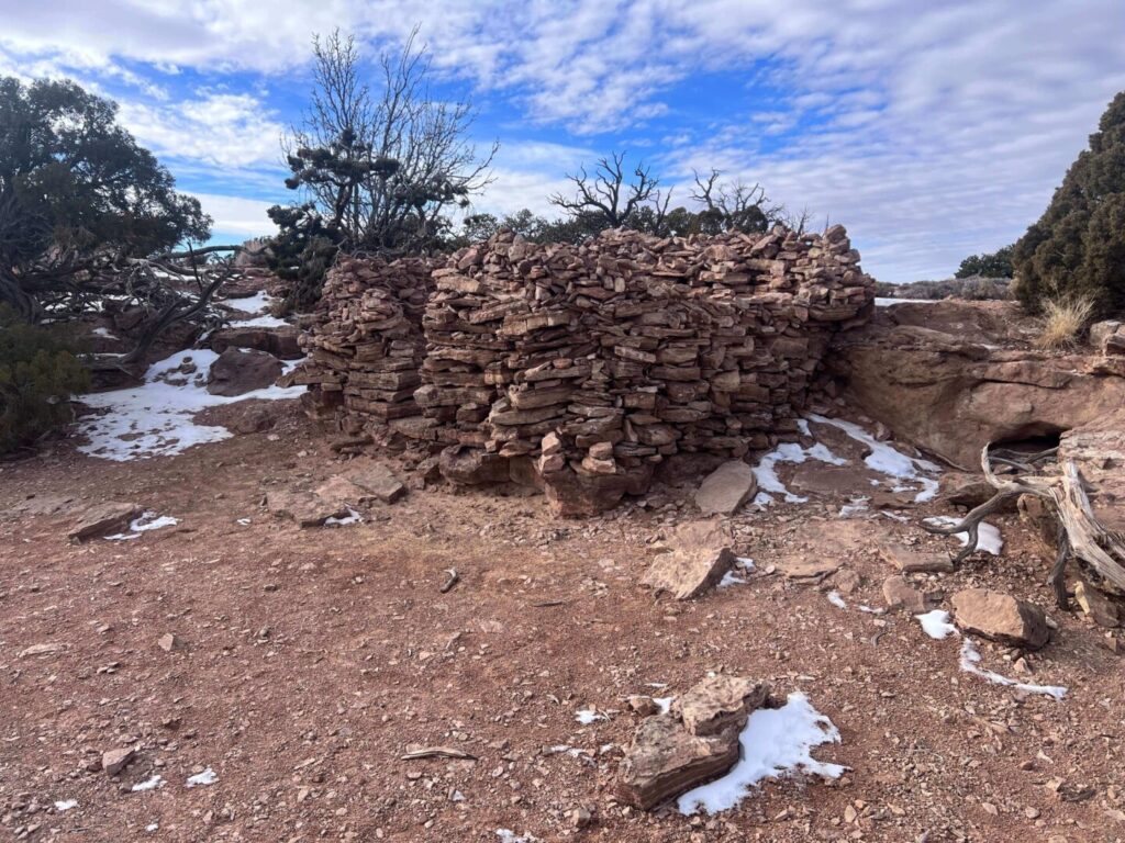
The Granaries
Tucked into alcoves in the sandstone walls of the butte are ancestral Puebloan granaries, small masonry structures built with fitted stone and mortar. They date to roughly 700-1,000 years ago and were used for food storage by the people who inhabited this canyon country long before it was a national park or a state or anything recognizable on a modern map.
The granaries are fragile and protected. Do not touch them. Do not climb on or near the alcoves. Stay back and observe. The NPS takes cultural site protection seriously in Canyonlands, and for good reason. These structures have survived centuries. Don’t be the person who contributes to their decline.
The combination of the granaries and the butte-top panorama is what separates Aztec Butte from a dozen other short hikes in the Island in the Sky district. It’s the history sitting inside the geology. That combination is rare.

Trail Difficulty and Length
Moderate is accurate. The 2.0-mile roundtrip isn’t demanding on distance or total elevation gain, roughly 225 feet. The difficulty comes from the slickrock scramble on the final push to the butte top. For hikers comfortable on uneven terrain and exposed rock, this is an easy moderate. For those who haven’t scrambled much, it’s a workout that requires some nerve.
Budget 1-2 hours for the round trip at a comfortable pace with time at the granaries and on the butte top. Photographers will want more time. The views from the butte are genuinely expansive and reward different compositions as you move around the perimeter.
Dog Friendly?
No. Canyonlands National Park prohibits pets on all trails, including Aztec Butte. Dogs are permitted in parking areas, campgrounds, and along paved roads, but must be leashed at all times and cannot go on unpaved surfaces or backcountry areas. For dog-friendly hiking in the broader Moab area, BLM land outside both parks offers options. Corona Arch Trail west of Moab on BLM land is a solid dog-friendly arch hike. The Mill Creek Parkway in Moab allows leashed dogs on its paved path along the creek.
What to Bring
Water first. Bring at least 2 liters per person. The butte top is fully exposed and the slickrock absorbs and radiates heat. There’s no water on the trail or at the trailhead. In summer, go heavier.
Sun protection: hat, sunscreen, sunglasses. Sturdy hiking shoes or trail runners for the slickrock scramble. Sandals are wrong here. The angled rock on the final push requires real grip.
For photography: a wide-angle lens for the butte-top panorama and a mid-range focal length for the granaries, which are recessed in shadow and benefit from a longer shot to compress the alcove detail.
Best Time to Hike Aztec Butte Trail
Spring and fall are the sweet spots: March through May and September through November. Temperatures are moderate, the light on the canyon country below the butte has warmth, and the trail is dry.
Summer is doable but the butte top becomes punishing by midday. Leave early, before 7 a.m., and plan to be back at the vehicle by 10 or 11 a.m. The granary alcoves provide minimal shade. In summer heat, this is not a long-linger hike.
Winter visits are quiet and the low-angled light does interesting things with the sandstone and the canyon geometry below. The slickrock scramble requires extra caution when wet or icy. Check conditions before committing.
For photography, morning is the better window for the butte top views, with the canyon dropping into shadow to the west and the eastern canyon country catching early light. The granaries are in north-facing alcoves and receive soft, reflected light through most of the day. Overcast days actually work well for shooting the granaries without the harsh contrast of direct sun.
Rules and Regulations
Do not touch or approach the granaries. These are irreplaceable cultural resources protected under the Archaeological Resources Protection Act. Touching, climbing on, or disturbing cultural sites is a federal offense in national parks.
Stay on designated trails and scramble routes. Cryptobiotic soil crust on the desert floor around the butte takes decades to recover from a single footprint. Walk on rock where the trail transitions to slickrock, and on the established path everywhere else.
Pack out all trash. No pets on trails. No drones without a permit. Leave No Trace principles apply throughout. The $35 vehicle fee or America the Beautiful Pass covers park entry.
Where to Stay Near Moab
Moab is the base for Canyonlands Island in the Sky, about 40 minutes east. The town has lodging at every price point. Red Cliffs Lodge on the Colorado River on Highway 128 and The Caves at Moab are two options with character beyond a standard hotel stay. For points travelers, check available Marriott Bonvoy properties in Moab, IHG Rewards hotels near Moab, and Hilton Honors options in the area. Spring and fall availability moves fast in Moab. Book well ahead.
Camping Nearby
Inside Canyonlands Island in the Sky, Willow Flat Campground is the only developed option. It’s small, first-come first-served, and has no water. Sites fill by mid-morning in peak season. If you want to camp inside the park, arrive the night before and claim your site early.
Outside the park, the BLM land around Moab has solid dispersed camping at Gemini Bridges, Porcupine Rim, and the Sandflats Recreation Area east of town. All three are well-established dispersed camping areas with Moab as the supply base. Sandflats has both dispersed and fee sites with facilities.
Nearby Adventures
Mesa Arch Trail is the obvious companion stop in Island in the Sky: 0.5 miles to the most-photographed arch in Canyonlands and a sunrise destination of its own. Grand View Point Trail at the end of the main park road delivers the most expansive canyon view in the district. Upheaval Dome Trail is the geological mystery of the park, a 1-mile out-and-back to an impact crater (or salt dome, depending on which theory you prefer).
White Rim Overlook Trail is the other short hike in Island in the Sky worth your time: 1.8 miles to a 1,200-foot drop view of the White Rim Road below and the Colorado River canyon beyond.
Dead Horse Point State Park sits on the edge of the canyon about 10 miles from the Island in the Sky entrance and offers one of the best overlooks in Utah with the Colorado River making a near-360-degree bend 2,000 feet below. Pair it with a Canyonlands day for a full mesa experience.
Plan This Hike
AllTrails has the Aztec Butte Trail mapped with offline GPS tracking and visitor reports. Worth pulling down before you lose service on UT-313. Plan your hike on AllTrails and download the offline map before leaving Moab.
Chase the Quiet
Aztec Butte is short. The granaries are old. The combination of standing on top of a butte in the middle of Canyonlands and looking at structures that have been in those alcoves longer than any building on the continent that you’d recognize is a specific kind of reset. Not many hikes deliver it. This one does. The drive is worth it, the scramble is worth it, and the granaries are worth standing back from in a way that respects what they’ve survived.
Support the Adventure
To make your walls less boring, check out my photography portfolio and bring a piece of the wild and my story into your home.
If you’d like to fuel future adventures, you can donate a coffee on Ko-Fi. Every cup keeps me chasing sunrises and stories.
When you shop using my affiliate links, every click helps support this blog at no extra cost to you. It’s a small way to keep Unicorn Adventure alive and kicking while I keep exploring.
Subscribe to my mailing list for future updates, new stories, and behind-the-scenes adventures.
Stay connected with me on Instagram and Facebook for more photos and daily inspiration.
Thanks for being part of the journey, Unicorn Squadron!

Theo Maynard is a landscape photographer and adventure blogger based in Salt Lake City. He chases remote desert and mountain light across the American West, documents it all solo, and shares the journey through Unicorn Adventure. He’s on the autism spectrum, and that’s not a footnote, it’s the whole story. He creates to inspire others to get outside, chase what lights them up, and live their best possible life. Unapologetically himself.