


The Glacier Gorge Trail to Sky Pond earns its hard rating specifically at Timberline Falls, about 5 miles in, where the trail stops being a trail and becomes a wet rock scramble up the side of a 30-foot waterfall. That’s not hyperbole in the description. You climb alongside the falls on exposed rock with water coming off the cliff face around you, and the beta on this section is straightforward: wet feet are likely, the rock is slippery, and your hands are going to be involved. After that, the trail continues to Lake of Glass and then Sky Pond, and both are worth every step of the climb. This guide covers the Sky Pond via Glacier Gorge Trail from trailhead to pond: what each section actually involves, the timed entry system you need to navigate, and how to plan a day that ends at the right lake at the right time.
Quick Facts
| Trail Name | Sky Pond via Glacier Gorge Trail |
| Location | Rocky Mountain National Park, near Estes Park, Colorado |
| Coordinates | 40.3103° N, 105.6404° W |
| Distance | 8.6 miles roundtrip |
| Elevation Gain | 1,771 feet |
| Difficulty | Hard |
| Time | 5–7 hours |
| Dogs Allowed | No (pets not permitted on park trails) |
| Fee | $35 per vehicle; free with America the Beautiful Pass |
| AllTrails | View on AllTrails |
How to Get There
Rocky Mountain National Park is accessible from Estes Park on US-34 and US-36. From Estes Park, take US-36 west into the park and follow the signs for Bear Lake Road. The Glacier Gorge Trailhead is on Bear Lake Road before the Bear Lake parking area, about 8 miles from the park entrance. The drive from Estes Park takes roughly 30 minutes depending on traffic and parking conditions. From Denver, plan about 1.5 hours: I-25 north to US-36 west through Lyons to Estes Park, then into the park. From Salt Lake City, roughly 7 hours via I-80 east and I-25 north. Estes Park has full services: hotels, restaurants, grocery stores. Stock up before driving into the park. Critical: Rocky Mountain National Park requires timed entry reservations May through October. Book at recreation.gov before arriving. The Bear Lake Road Corridor has a separate reservation from general park entry and sells out fast. Without both reservations during peak season, you will not access this trailhead. Check nps.gov/romo for current requirements before your trip.
Parking Information
The Glacier Gorge Trailhead has a separate small lot from Bear Lake, but it fills as fast or faster on summer mornings. Expect it to be full by 7-8 a.m. on weekends and many weekdays in peak season. The free NPS shuttle from the Glacier Basin Park & Ride serves the Glacier Gorge Trailhead stop on its Bear Lake Road route. This is the recommended approach during peak season. Park at Glacier Basin, take the shuttle to Glacier Gorge Junction, and start from there. The shuttle runs throughout the day and is included with park entry. Restrooms and information signs are available at the trailhead. Fill your water here before starting since the first reliable water on the trail is Alberta Falls creek. 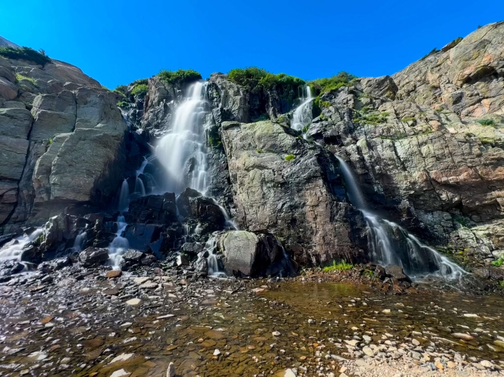
Cell Service and Navigation
Cell coverage in the park is inconsistent and drops as you gain elevation on the Glacier Gorge Trail. Download AllTrails offline in Estes Park before driving in. The trail is well-signed at key junctions, but having GPS active is useful in the Timberline Falls scramble section where the route across wet rock requires visual confirmation that you’re on the established path. The Glacier Gorge Trail branches at several points, with spurs leading to other lakes and destinations. Signs at each junction are clear, but knowing which direction you’re heading before you get to a junction is better than reading signs under pressure when you’re cold and wet from the falls scramble.
What to Expect on the Sky Pond via Glacier Gorge Trail
Alberta Falls comes about 0.8 miles from the trailhead and is one of the more photographed waterfalls in the park. The 30-foot cascade drops into a rocky gorge below the trail, and the surrounding granite and pine frame it cleanly. Most trail users stop here, photograph it, and turn around. That’s a valid use of the Glacier Gorge Trail if you’re not up for the full commitment to Sky Pond. For Sky Pond hikers, Alberta Falls is just the warm-up. The light hits the falls best in morning before the canyon walls shade the water. Get here early if photography at the falls is part of the objective. Past Alberta Falls, the trail continues up the gorge and reaches The Loch at roughly 2.5 miles. This alpine lake sits at 10,180 feet with peaks rising above it on three sides and the Loch Vale drainage continuing upward toward Timberline Falls. The Loch is a natural break point: there’s room to sit, the views are solid, and it’s the last easy terrain before the trail commits to harder ground. The Loch also has a split where the Andrews Tarn Trail branches right. Stay left toward Timberline Falls for Sky Pond. Timberline Falls is the crux. The trail reaches the base of a 30-foot waterfall and continues up alongside it on exposed rock with water spray and wet stone underfoot. This section requires using your hands. The route is established and worn but not obvious in all conditions. Slow down and find your footing before committing to each move. Wet conditions after rain or in early season make this section significantly more difficult. The rock is slicker when wet and the spray from the falls coats the approach surface. If you’re arriving after recent rain, assess honestly before committing to the scramble. If the rock looks manageable, go slowly and methodically. If it looks genuinely dangerous, turn around at The Loch. Sky Pond will still be there on a dry day. After the scramble, the terrain levels somewhat on the approach to Lake of Glass. Lake of Glass sits just above the Timberline Falls scramble at around 10,900 feet, clear and still when there’s no wind, reflecting the cliffs above. It’s a dramatic spot and a preview of what Sky Pond delivers with more rugged surroundings. Sky Pond is the final destination, a short distance above Lake of Glass at 10,900 feet. The pond sits in a cirque beneath the jagged ridgeline of Sharkstooth and Taylor Peak, with cliffs rising directly above the water on three sides. The remote, enclosed quality of Sky Pond is what separates it from The Loch or Lake of Glass: it feels genuinely removed from the trail system below, earned by distance and the scramble, and the hikers who make it there tend to have the place to themselves for longer than you’d expect in a national park this popular. 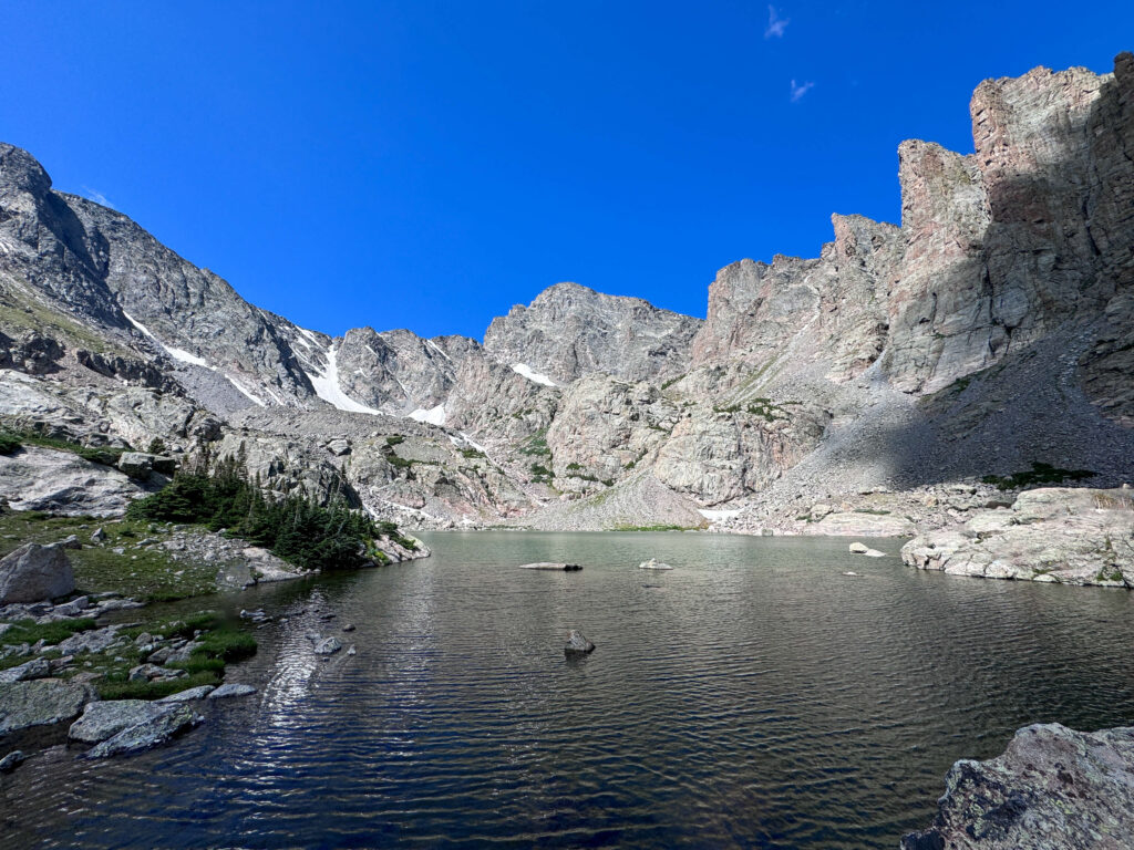
Trail Difficulty and Length
This trail is 8.6 miles roundtrip with 1,771 feet of elevation gain. Hard is accurate, earned specifically by the Timberline Falls scramble and the cumulative distance and elevation. Experienced hikers who regularly do 8-plus-mile days at elevation handle this well. Hikers who are newer to mountain terrain should be honest about whether the scramble section is within their comfort zone before committing to the full route. Budget 5-7 hours for the full roundtrip at a realistic pace with time at Alberta Falls, The Loch, Timberline Falls, and Sky Pond. Photographers who work at each location should add time generously. The trailhead starts at around 9,200 feet and Sky Pond is near 10,900 feet. Altitude is a factor for visitors from lower elevations.
Dog Friendly?
No. Rocky Mountain National Park prohibits pets on all trails including the Glacier Gorge Trail. Dogs are permitted in parking areas, campgrounds, and paved roads, but cannot access any unpaved surface in the park. For dog-friendly hiking near Estes Park, the Roosevelt National Forest outside the park boundaries has options for leashed dogs. 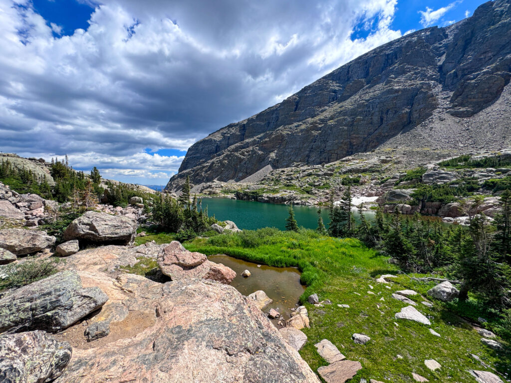
What to Bring
Water: minimum 3 liters per person. The trail is long and the Timberline Falls scramble is physically demanding. Dehydration at altitude compounds quickly. Bring more than you think you need. Waterproof footwear or shoes you’re comfortable getting wet: the Timberline Falls section will wet your feet if conditions are typical. Trail runners work if you accept wet feet; waterproof hiking boots with good grip are the better option for the scramble section. Layers: mornings at the Glacier Gorge Trailhead are cold even in July. The trail above timberline at Sky Pond is exposed to wind and afternoon weather. A rain shell and a mid-layer are mandatory regardless of the morning forecast. Afternoon thunderstorms over the Rockies are the primary safety variable in summer. Trekking poles for the descent from Timberline Falls scramble, where they help with stability on the steep, wet rock. Sun protection for the exposed upper sections above The Loch.
Best Time to Hike Sky Pond
July through September is the reliable window. The Timberline Falls scramble section can carry snow and ice into June and the rock is more hazardous in those conditions. Check trail conditions with the park or recent AllTrails reports before going in June. July and August bring the highest traffic and the highest afternoon thunderstorm frequency. Start the hike no later than 6 a.m. and plan to reach Sky Pond by noon or shortly after. The exposed terrain above The Loch and the Timberline Falls section put you in lightning exposure territory if a storm develops in the afternoon. Turn around at The Loch or below if the sky is building before you’ve reached the falls September is the best overall month. Afternoon storm frequency drops, temperatures are comfortable for the full day, and the crowds thin noticeably. The aspen color on the lower sections of Bear Lake Road in late September adds a visual bonus to the drive in and out. For photography: Alberta Falls photographs best in the first hour after sunrise when direct light reaches the falls. Dream Lake (on the parallel Four Lake Loop route) is the classic sunrise photography stop in this corridor. Sky Pond itself rewards late morning light after the early shadows clear from the cirque walls. The Timberline Falls scramble section is a challenging environment for camera gear, so secure it well before the wet rock section.
Rules and Regulations
Timed entry reservations are required May through October. The Bear Lake Road Corridor reservation is separate from general park entry. Both are required during peak season and both can sell out. Book at recreation.gov before your trip. Stay on the designated trail. The Glacier Gorge corridor sees heavy visitor impact and the fragile alpine vegetation around The Loch and the upper lakes is easily damaged by off-trail foot traffic. No pets on trails. Pack out all trash. No drones without a special use permit. Leave No Trace principles apply throughout. The park fee is $35 per vehicle or free with an America the Beautiful Pass.
Where to Stay Near Estes Park
Estes Park is the obvious base, a full mountain resort town at the park entrance with lodging at every price point. The Stanley Hotel is the historic landmark in town.
Camping Nearby
Glacier Basin Campground is the closest developed option, also home to the Park & Ride shuttle stop for the Bear Lake Road corridor. Reservations through recreation.gov. Moraine Park Campground is larger and available for a wider range of dates. Both book out months in advance for summer weekends. An early-morning start to Sky Pond is significantly easier if you’re camping inside the park.
Nearby Adventures
The Four Lake Loop Trail from the Bear Lake Trailhead visits Nymph Lake, Dream Lake, Emerald Lake, and Lake Haiyaha in 7.2 miles with 1,351 feet of gain. A different character from Sky Pond: more lakes, less scrambling, better for photographers targeting Dream Lake sunrise. Trail Ridge Road is the non-hiking must-do in Rocky Mountain National Park. The highest continuous paved road in the US crosses the alpine tundra at over 12,000 feet and provides summit-level views accessible to any vehicle. Worth a separate afternoon. The town of Estes Park has elk visible in town at dawn and dusk throughout the year, particularly in fall during the rut. The Estes Park Riverwalk along Fall River is a paved, flat walk through town accessible to all visitors. The Stanley Hotel offers tours for those interested in its history and King connection.
Plan This Hike
AllTrails has Sky Pond via Glacier Gorge Trail mapped with offline capability, recent condition reports from other hikers, and the ability to track your GPS position without data. Download it before you enter the park. Condition reports from other hikers in the week before your visit are the best source for current Timberline Falls scramble conditions. Plan your hike on AllTrails and pull the offline map while you’ve still got signal in Estes Park.
Chase the Quiet
The Timberline Falls scramble is the moment on this trail that most people remember longest. Not the pretty parts, the scramble. Because it asks something of you that most Bear Lake corridor trails don’t: actual problem-solving, wet hands, the decision to commit to a move on slick rock with water coming down around you. And then you’re through it and above it and the terrain opens into Lake of Glass and then Sky Pond and the cirque walls of Sharkstooth and Taylor Peak. The difficulty is the point. It filters the trail down to the people who wanted all of it.
Support the Adventure
To make your walls less boring, check out my photography portfolio and bring a piece of the wild and my story into your home. If you’d like to fuel future adventures, you can donate a coffee on Ko-Fi. Every cup keeps me chasing sunrises and stories. When you shop using my affiliate links, every click helps support this blog at no extra cost to you. It’s a small way to keep Unicorn Adventure alive and kicking while I keep exploring. Subscribe to my mailing list for future updates, new stories, and behind-the-scenes adventures. Stay connected with me on Instagram and Facebook for more photos and daily inspiration. Thanks for being part of the journey, Unicorn Squadron!

Theo Maynard is a landscape photographer and adventure blogger based in Salt Lake City. He chases remote desert and mountain light across the American West, documents it all solo, and shares the journey through Unicorn Adventure. He’s on the autism spectrum, and that’s not a footnote, it’s the whole story. He creates to inspire others to get outside, chase what lights them up, and live their best possible life. Unapologetically himself.