Four alpine lakes in 5 miles. That’s the premise of this route in the High Uintas Wilderness, and the execution matches the premise. Ruth Lake, Jewel Lake, Cutthroat Lake, and Teal Lake are strung through the same basin on the upper Mirror Lake Highway corridor, each with its own character, each reachable from the Ruth Lake Trailhead in a single day with some navigation engagement after the first mile. The route-finding starts early and that’s part of what keeps this one interesting.
The Uintas lake basin country rewards this kind of multi-lake route. The terrain between lakes in the High Uintas is open enough to navigate but varied enough to feel like you’re actually moving through different landscapes rather than just clocking miles. Each body of water in the basin has its own sensory quality: how the reflection changes with the surrounding terrain, how the sound of the water changes from inlet to outlet to open shore. Four lakes means four distinct versions of that. The route delivers all of them in a half-day commitment.
This guide covers the Ruth Lake four-lake route from the Ruth Lake Trailhead: what the navigation situation involves, what each lake delivers, and how to prepare for a hike that shifts from maintained trail to route-finding quickly.
Quick Facts
|
Trail Name |
Ruth Lake, Jewel Lake, Cutthroat Lake, and Teal Lake Route |
|
Location |
High Uintas Wilderness, near Kamas, Utah |
|
Coordinates |
|
|
Distance |
~5 miles (route, not a marked loop) |
|
Elevation Gain |
~700 feet |
|
Difficulty |
Moderate with route-finding (download GPS map before going) |
|
Time |
3-5 hours |
|
Dogs Allowed |
Yes, on leash |
|
Fee |
Mirror Lake Highway pass: $10 (1-3 day) or $20 (7-day); America the Beautiful Pass accepted |
|
AllTrails |
How to Get There
From Kamas, take Mirror Lake Highway (UT-150) east approximately 35 miles. Watch for the signed Ruth Lake Trailhead on the left side of the highway. The trailhead is clearly marked and the parking area is visible from the road.
From Salt Lake City, plan about 1.75 hours: I-80 east to US-40 east toward Heber City, then UT-248 east to Kamas, then Mirror Lake Highway east. From Park City, Kamas is about 20 minutes south on UT-32. The trailhead sits at the upper end of the Mirror Lake Highway corridor, past the Bald Mountain Pass area.
Mirror Lake Highway closes November 1st and reopens around Memorial Day weekend depending on snowpack. The Ruth Lake Trailhead and this route are inaccessible during the winter months. Check current conditions before a June visit; the upper highway corridor can hold snow longer than the lower sections.
Parking Information
The Ruth Lake Trailhead has a designated parking area off the Mirror Lake Highway. It’s smaller than the Crystal Lake or Bald Mountain Pass lots and fills faster on summer weekends. Arrive before 8 a.m. on peak days. No restrooms at the trailhead; plan accordingly before leaving the Mirror Lake area with facilities.
Mirror Lake Highway pass required: $10 for 1-3 days, $20 for 7 days. America the Beautiful Annual Pass accepted. Self-serve kiosks at multiple points on the highway.

Cell Service and Navigation
This section matters more for this route than for most Uintas hikes. Cell coverage is absent at the Ruth Lake Trailhead and throughout the route. Download AllTrails offline before leaving Kamas. The GPS track is essential: the route-finding begins after about a mile of maintained trail and continues through the four-lake basin. Without an offline map and active GPS, this route is significantly harder than its moderate rating suggests.
This route has a defined sequence of lake targets: Ruth, Jewel, Cutthroat, Teal. Navigating between named lakes with GPS coordinates is more structured than open basin navigation, but it still requires active map engagement throughout the upper section.
Bring a backup power source for your phone. A downloaded map on a dead phone is no map at all. A Garmin inReach or dedicated GPS unit is worth carrying on any route with significant navigation requirements and no cell coverage.
What to Expect on the Ruth Lake Four-Lake Route
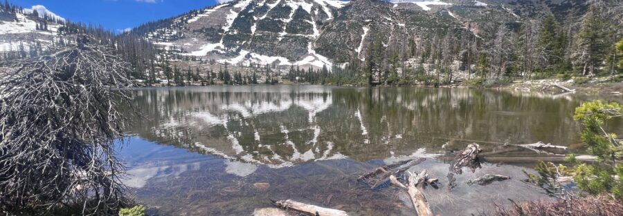
Ruth Lake
The maintained trail from the trailhead reaches Ruth Lake within the first mile. This first section is the easiest navigation and the most defined path. Ruth Lake is the largest of the four lakes on the route, with cliffs visible above the far shoreline and wildflowers in the meadow sections around the inlet through July. It’s a natural staging area for the rest of the route: rest here, check your GPS, confirm your plan for the next lake before leaving the maintained trail behind.
Jewel Lake
Past Ruth Lake, the maintained trail ends and the route-finding begins. Jewel Lake sits in a more enclosed basin than Ruth, smaller and more secluded, with the surrounding terrain creating a pocket of quiet that distinguishes it from the open approach of the first lake. The navigation between Ruth and Jewel requires reading the terrain carefully; there’s no trail, just the most sensible line through the alpine ground between the two water bodies.
Cutthroat Lake
Cutthroat Lake earns its name from the fish rather than anything alarming about the terrain. The lake holds cutthroat trout, visible near the surface in calm conditions, and fishing with a Utah license is permitted. The clear water and the visibility of the fish make Cutthroat Lake one of the more distinctive visual experiences on the route. Navigation continues between Jewel and Cutthroat with GPS coordination.
Teal Lake
Teal Lake is the most remote stop on the route, the furthest from the trailhead and the least visited as a result. The surrounding terrain at Teal is the most open of the four lakes, with broader views of the Uintas ridgeline above the basin. It’s the payoff lake: the one that requires the most navigation and rewards with the most solitude. The return from Teal Lake reverses the route back toward Ruth Lake and the trailhead.
Trail Difficulty and Length
Moderate with route-finding is the correct difficulty label. The maintained trail section is easy, but the navigation sections add a meaningful difficulty layer beyond what the gain and mileage alone indicate. Budget 3-5 hours for the full four-lake route at a navigation-conscious pace. Moving between lakes takes longer than moving along a marked trail of equivalent distance.
Dog Friendly?
Yes. High Uintas Wilderness allows leashed dogs. The route-finding sections require you to pay attention to where you’re going, which means less bandwidth for managing a dog that’s pulling or exploring off-leash. Keep dogs reliably leashed throughout. The lake access at each stop gives dogs water opportunities across the route.
The five-mile distance and the navigation requirement make this a more demanding day for dogs than the mileage alone suggests. Bring at least a liter of water for dogs in addition to lake access, and monitor for fatigue in the later miles when the route-finding requires sustained attention from you.

What to Bring
Navigation equipment first. AllTrails downloaded offline with the GPS track active. Backup phone power. GPS coordinates for all four lakes pre-loaded so you have targets to navigate between. A printed paper backup map if you’re doing serious route-finding in a wilderness area.
Water: 2-3 liters. The lakes on the route are refill sources with treatment or filtration, but carry enough to reach Ruth Lake without depending on trail sources. Layers for the exposed sections above the forest. Rain shell mandatory for afternoon storm conditions. Sun protection for the open basin terrain between lakes.
Fishing rod and Utah license if you want to fish Cutthroat Lake specifically. Trail runners or hiking boots for the varied terrain between the marked trail and the open alpine ground in the upper basin.
Rules and Regulations
Leave No Trace principles apply throughout the High Uintas Wilderness. Pack out everything. Camp at least 200 feet from water sources. Overnight camping requires a self-registration permit at the trailhead. Day hikes do not require a permit.
No fires in most Wilderness areas above 10,000 feet; check current restrictions. Dogs on leash. Fishing with a valid Utah license. Stay on established trail where it exists; walk on rock rather than soil or vegetation in the route-finding sections between lakes.
Where to Stay Near Kamas
Kamas is the nearest town, about 35 miles west on Mirror Lake Highway. Park City, 20 minutes south of Kamas on UT-32, has full resort infrastructure. Salt Lake City is 1.75 hours west. For points travelers, check available Marriott Bonvoy properties, IHG Rewards hotels, and Hilton Honors options in Park City and Salt Lake.
Camping Nearby
The upper Mirror Lake Highway corridor has several campgrounds including Lily Lake, Butterfly Lake, and Lofty Lake Trailhead area. Mirror Lake Campground, back toward Kamas, is the largest developed option with facilities and reservations through recreation.gov. High Uintas Wilderness dispersed camping is permitted with a self-registration permit from the Ruth Lake Trailhead for overnight multi-lake trips.
Nearby Adventures
The 20 Lakes Trail Loop from the Crystal Lake Trailhead is the more complex navigation companion to this route: a full route-finding loop through a larger lake basin a few miles back toward Kamas on the highway. If you’ve done this four-lake route and want more navigation practice in a bigger arena, the 20 Lakes Loop is the next step.
Bald Mountain Trail from the Bald Mountain Pass area is the summit option in the same Mirror Lake Highway corridor, accessible without navigation skills and offering the high-elevation view of the lake country you just walked through.
Hayden Peak from the same area is the hard summit option at 12,479 feet. Haystack Lake Trail and the Mirror Lake Loop are the easy alternatives for recovery days or family days from a Uintas base camp.
Upper Provo River Falls, back toward Kamas on the highway, is the easy waterfall stop that works as a natural bookend to this four-lake day on the drive in or out.
Plan This Hike
AllTrails has the Ruth Lake four-lake route mapped with offline GPS tracking and condition reports. The GPS track is the most important element for this route. Download it before you lose signal on Mirror Lake Highway. Plan your hike on AllTrails and pull the offline map and GPS track while you’ve still got signal in Kamas.
Chase the Quiet
Four lakes in 5 miles means four different versions of the same basic premise: the Uintas at 10,000 feet, clear water, mountain walls above, the particular air of the high basin. Ruth is the biggest. Jewel is the most enclosed. Cutthroat is where the trout are visible. Teal is the farthest and the quietest. None of them are the same. That’s the route’s specific value: not just doing more of the same lake experience, but doing four distinct variations of it in a single day. That’s worth the navigation commitment to get there.
Support the Adventure
To make your walls less boring, check out my photography portfolio and bring a piece of the wild and my story into your home.
If you’d like to fuel future adventures, you can donate a coffee on Ko-Fi. Every cup keeps me chasing sunrises and stories.
When you shop using my affiliate links, every click helps support this blog at no extra cost to you. It’s a small way to keep Unicorn Adventure alive and kicking while I keep exploring.
Subscribe to my mailing list for future updates, new stories, and behind-the-scenes adventures.
Stay connected with me on Instagram and Facebook for more photos and daily inspiration.
Thanks for being part of the journey, Unicorn Squadron!

Theo Maynard is a landscape photographer and adventure blogger based in Salt Lake City. He chases remote desert and mountain light across the American West, documents it all solo, and shares the journey through Unicorn Adventure. He’s on the autism spectrum, and that’s not a footnote, it’s the whole story. He creates to inspire others to get outside, chase what lights them up, and live their best possible life. Unapologetically himself.