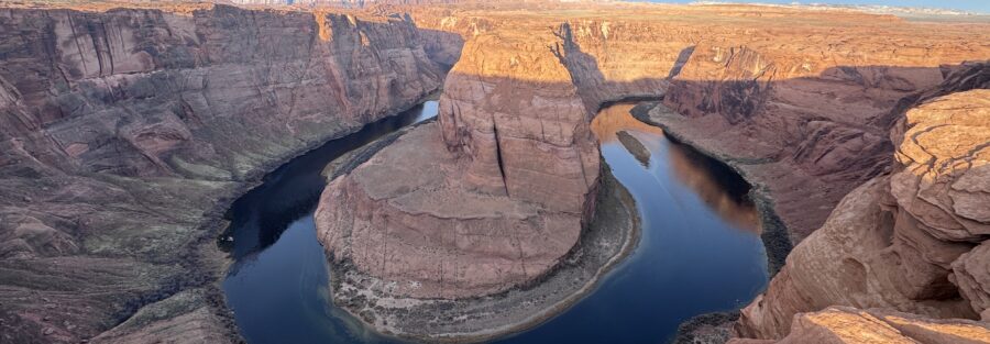
Horseshoe Bend is the Colorado River making a 270-degree curve around a massive Navajo Sandstone formation south of Page, Arizona, visible from a 1,000-foot overlook above the river. The 1.5-mile roundtrip paved trail from the parking area earns its place as one of the most photographed natural features in the American Southwest; the view from the overlook is genuinely one of the better ones the Colorado Plateau delivers, and the plateau delivers a lot of good views.
Quick Facts
|
Trail Name |
Horseshoe Bend Trail |
|
Location |
Glen Canyon National Recreation Area, near Page, Arizona |
|
Coordinates |
|
|
Distance |
1.5 miles roundtrip |
|
Elevation Gain |
~150 feet |
|
Difficulty |
Easy |
|
Time |
45-75 minutes |
|
Dogs Allowed |
Yes, on leash |
|
Fee |
$10 parking fee |
|
AllTrails |
How to Get There
From Page, Arizona, head south on US-89 for about 5 miles. Watch for the clearly marked Horseshoe Bend parking area turnoff on the right. The trailhead is directly off the highway; the parking lot is visible from the road.
From Salt Lake City, Page is about 4.5-5 hours south via I-15 and US-89 through Kanab. From Las Vegas, about 4 hours northeast on I-15 and US-89. From Flagstaff, about 2 hours north on US-89. From Grand Canyon South Rim, about 2.5 hours north via AZ-64 and US-89.
Parking Information
The Horseshoe Bend parking area is a large well-maintained lot managed by the National Park Service with a $10 parking fee. America the Beautiful Annual Pass is not accepted. The lot fills by mid-morning during peak season (March through November) and can require waits for spots on busy days. Arrive before 8 a.m. or after 3 p.m. on peak days to avoid the longest waits. Restrooms are available at the trailhead. The lot was significantly expanded and paved in recent years with improved facilities; the experience is more managed than it was before the improvements.

What to Expect on the Trail
The trail from the parking area to the overlook is paved, well-maintained, and accessible. It gains 150 feet through desert terrain with a few sandy sections on the final approach. The trail surfaces reflect heat in summer and can be significantly hotter than the ambient temperature. Pavement temperatures in July and August midday are serious concerns for feet and dog paws.
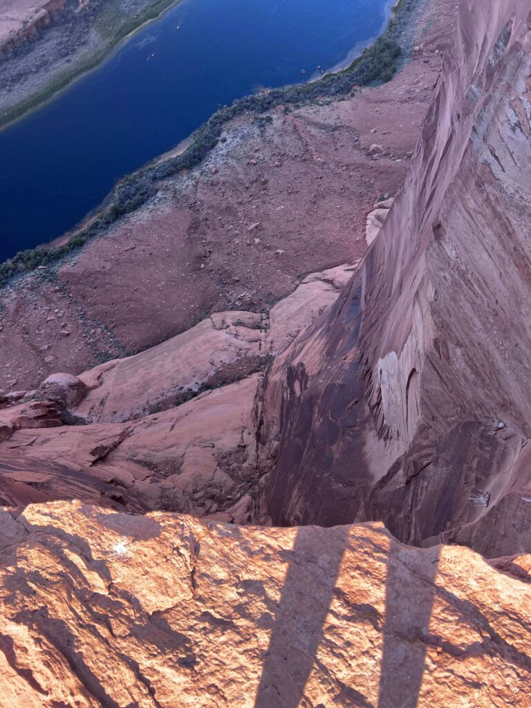
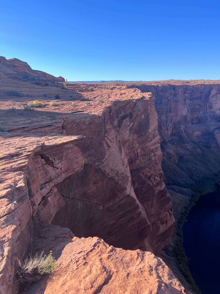
The overlook is fenced on portions of the edge, but sections remain unfenced. The drop is 1,000 feet to the river. Exercise judgment near the unguarded edges, particularly with children and dogs. The number of visitor incidents at this overlook over the years has prompted additional safety infrastructure; follow all posted guidance.
The view: the Colorado River bends 270 degrees around the Navajo Sandstone formation below, the river a deep blue-green against the red canyon walls. The scale of the formation and the depth of the canyon are difficult to fully register until you’re standing at the rim looking down. It photographs well from multiple positions along the overlook. Sunrise and sunset are the premium times.
Photography at Horseshoe Bend
The overlook faces west-northwest, which makes sunrise the best light from the viewing position: the sun rises behind you and illuminates the canyon walls and the river below. Sunset light on the canyon walls is also excellent, with the Navajo Sandstone going deep red in the last hour before dark.
A wide-angle lens is nearly mandatory for the full horseshoe composition; standard focal lengths can’t capture the curve and the canyon context simultaneously. A 16mm or wider on a full-frame body captures the full bend with canyon context. Mid-range works for detail shots of the river and canyon walls. A polarizing filter manages river surface glare.
The trail is heavily trafficked and the overlook is crowded during peak hours. Sunrise arrivals (before 6 a.m. in summer) give you the light and the solitude simultaneously. Weekday visits in shoulder season (November, February, early March) are the least crowded windows for anyone who wants extended time at the overlook without managing other visitors in the frame.
Trail Difficulty and Length
Easy is accurate. The paved trail and modest elevation gain make this accessible to essentially any ambulatory visitor. The desert heat is the primary physical variable; a short easy trail in 105°F heat with full sun exposure is harder than the distance and elevation suggest. Carry more water than you think you need.
Dog Friendly?
Yes. Dogs are welcome on leash. The trail is paved and manageable for dogs. Two serious considerations: pavement heat in summer can burn paws, and the unfenced overlook sections with a 1,000-foot drop require vigilant leash management. Dogs that pull or are unpredictable near edges should stay back from the unguarded sections. Bring water for dogs; the desert heat dehydrates them fast.
What to Bring
Water: at least 1.5 liters per person, more in summer. The desert sun and reflected heat from the trail surface dehydrate faster than the short distance suggests. Sun protection: hat, sunscreen, sunglasses. Camera with wide-angle capability and a polarizing filter. Paw protection for dogs in summer (booties or early-morning timing).
Best Time to Visit
Spring (March through May) and fall (September through November) offer the most comfortable temperatures and the best crowd management. Peak season runs roughly March through November with the highest volume from spring break through summer.
For photography: sunrise arrivals are the priority for light quality and crowd management simultaneously. The parking lot opens before sunrise in peak season. Sunset visits are also excellent; plan to arrive 90 minutes before sunset to get a parking spot and walk the trail before the light window.
Summer: possible with early morning arrivals (before 7 a.m.) or late afternoon. Midday in July and August is a heat risk, particularly for children and dogs. Winter: cool temperatures and significantly reduced crowds with excellent light on the canyon walls on clear days.
Rules and Regulations
Stay on the designated trail. Exercise extreme caution near unfenced overlook edges. The drop is 1,000 feet. Leave No Trace principles throughout. Dogs on leash. Pack out all trash. No drones without a special use permit. $15 parking fee or America the Beautiful Pass.
Where to Stay in Page
Page has full chain hotel infrastructure on Lake Powell Boulevard and US-89. For points travelers, check available Marriott Bonvoy properties in Page, IHG Rewards hotels in Page, and Hilton Honors options in Page. Book well ahead for spring and fall peak periods when Page’s limited inventory fills fast.
Nearby Adventures
Dam Overlook Trail (0.5 miles, direct view of the dam from above), Glen Canyon Bridge (1-mile paved bridge walk, 700 feet above the Colorado River), Hanging Garden Trail (1.2 miles / 62 ft gain), Colorado River via Lees Ferry (2.5 miles / 101 ft gain), and Beehive Trail / The New Wave. Horseshoe Bend as a morning stop followed by the Dam Overlook and Glen Canyon Bridge walk is a natural full-morning sequence.
Antelope Canyon is a few miles east of Page: guided tours of the upper and lower slot canyons, the most-visited slot canyons on Earth. Book well in advance; the guided tour requirement means on-site same-day access is not reliable.
Plan This Hike
AllTrails has Horseshoe Bend Trail mapped with offline capability and recent crowd reports. Download before leaving Page. Plan your visit on AllTrails and use the condition reports to check current parking and crowd levels before your visit.
Chase the Quiet
There’s a version of Horseshoe Bend that most visitors don’t get: standing at the overlook before the lot is full, before the other photographers have set up on the rim, in the first direct light of the morning when the canyon walls are still half in shadow and the river below is catching the first sun. That version exists. It requires waking up early enough to be in a parking lot in Arizona while it’s still dark. It’s worth the alarm clock. The view that shows up in ten million social media posts is the same view. The experience of having it before the crowd does is different.
Support the Adventure
To make your walls less boring, check out my photography portfolio and bring a piece of the wild and my story into your home.
If you’d like to fuel future adventures, you can donate a coffee on Ko-Fi. Every cup keeps me chasing sunrises and stories.
When you shop using my affiliate links, every click helps support this blog at no extra cost to you. It’s a small way to keep Unicorn Adventure alive and kicking while I keep exploring.
Subscribe to my mailing list for future updates, new stories, and behind-the-scenes adventures.
Stay connected with me on Instagram and Facebook for more photos and daily inspiration.
Thanks for being part of the journey, Unicorn Squadron!

Theo Maynard is a landscape photographer and adventure blogger based in Salt Lake City. He chases remote desert and mountain light across the American West, documents it all solo, and shares the journey through Unicorn Adventure. He’s on the autism spectrum, and that’s not a footnote, it’s the whole story. He creates to inspire others to get outside, chase what lights them up, and live their best possible life. Unapologetically himself.