The New Wave and the Beehive Trail are in Glen Canyon NRA just off the approach road to the Glen Canyon Dam, about 10 minutes from downtown Page. The area has wave-like Navajo Sandstone formations that resemble the famous Wave in Coyote Buttes North, but without a permit requirement and without the 2-hour drive. The 1.5-mile exploration covers both the Beehive formation area and the New Wave sandstone in a short, accessible walk through distinctive rock terrain.
Quick Facts
|
Trail Name |
Beehive Trail / The New Wave |
|
Location |
Glen Canyon National Recreation Area, near Page, Arizona |
|
Coordinates |
|
|
Distance |
~1.5 miles (exploration-based; distance varies) |
|
Elevation Gain |
~150 feet |
|
Difficulty |
Easy |
|
Time |
45-90 minutes |
|
Dogs Allowed |
Yes, on leash |
|
Fee |
No entry fee; Glen Canyon NRA vehicle entry may apply depending on approach |
|
AllTrails |
How to Get There
From Page, Arizona, head west on US-89 toward the Glen Canyon Dam. Before crossing the dam bridge, turn left onto a dirt road marked for The New Wave / Beehive Trail. Follow the road approximately half a mile to the parking area. The drive from downtown Page takes about 10 minutes.
From Kanab or points west, take US-89 east toward Page. The turnoff is visible before you reach the dam crossing. The road is well-traveled and accessible to most standard vehicles in dry conditions.
Parking Information
Small free dirt parking area at the trailhead, directly accessible from the turnoff road. The area sees far less traffic than Horseshoe Bend, making parking typically straightforward even on busy days in Page. No facilities; use Page amenities before the short drive out. Check current access routes and any NPS guidance before visiting, as the road near Glen Canyon Dam infrastructure may have periodic access requirements.

Cell Service and Navigation
Cell coverage is solid near Page and the dam approach road. Download AllTrails offline as standard practice. The Beehive Trail and New Wave area is compact; navigation within the formation is exploration-based rather than trail-following. GPS is useful for staying oriented in the formation cluster and finding your way back to the parking area in the undifferentiated sandstone terrain.
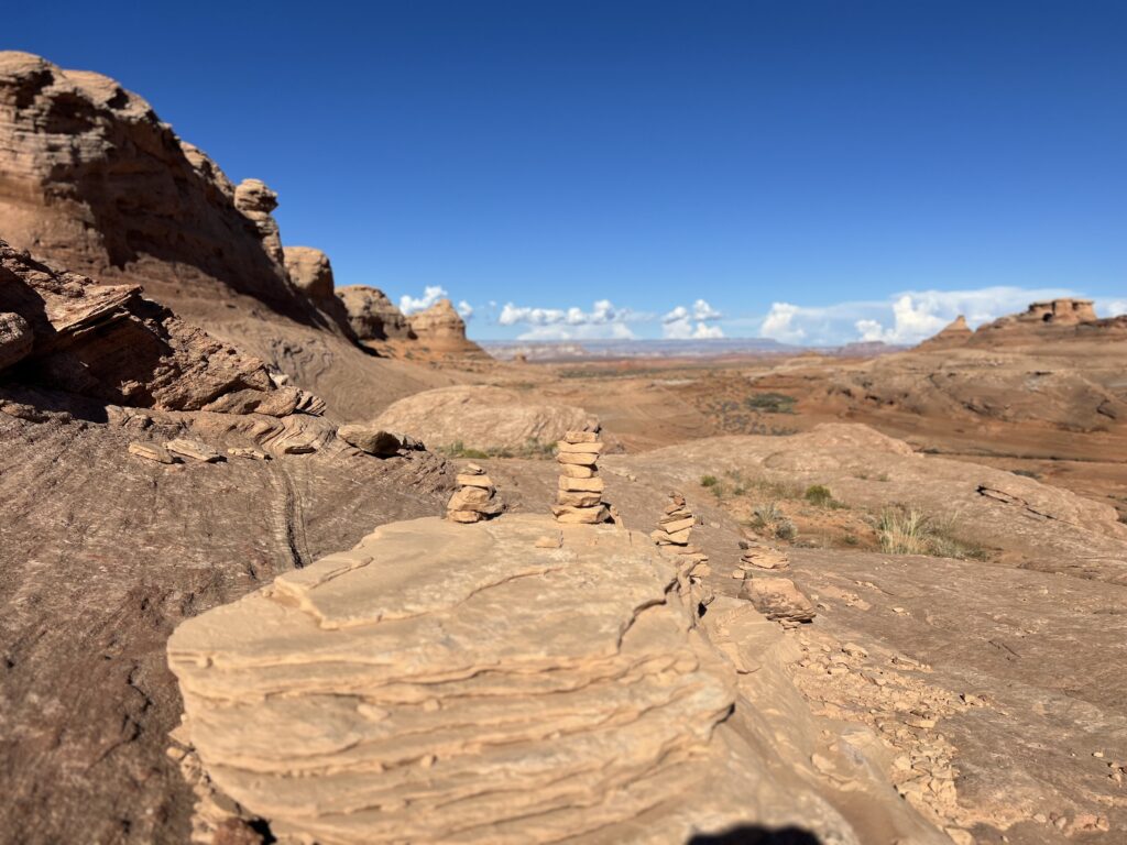
What to Expect at the Beehive Trail and The New Wave
The Beehive Formation
The Beehive area gets its name from the honeycomb or beehive-like erosion patterns visible on certain rock surfaces in the area. This weathering pattern, called tafoni, is created when salt or moisture erodes soft rock interiors while leaving harder outer surfaces, creating a pockmarked or cellular texture. The Beehive formation is a specific expression of this erosion in the Glen Canyon sandstone and creates a visually distinctive texture unlike the smooth wave forms.
The New Wave
The New Wave refers to the wave-like Navajo Sandstone formations in the same area: undulating rock surfaces with the swirling crossbed patterns that make the famous Wave in Coyote Buttes North one of the most sought-after photography destinations in the Southwest. At The New Wave, the same geological process created similar formations accessible without a permit and without the backcountry logistics. The scale is smaller than Coyote Buttes North but the pattern character is comparable.
The color range runs from the deep orange-red of iron-saturated rock to lighter tans and whites in the lower-mineral sections. The contrast and saturation are highest in direct morning and late afternoon light.
For photography: the formations face multiple directions and the best light angle shifts throughout the day. Early morning for the east-facing sections, late afternoon for the west-facing. Wide-angle for the formation pattern in landscape context, macro for the texture detail, mid-range for the tafoni pattern on the Beehive sections. Small seasonal pools in the formation depressions reflect the sky when present.
Exploration vs. Trail
There’s no marked trail through the formation area once you leave the approach path from the parking area. Exploration through the formations is self-directed. The area is compact enough that getting genuinely lost is unlikely, but keeping your orientation toward the parking area requires attention. GPS active or periodic check of direction from known landmarks.
No shade in the formation area; the white sandstone reflects heat in summer. Water stops and a turnaround plan are appropriate even for a short visit.
Trail Difficulty and Length
The trail is 1.5 miles with 150 feet of gain. Easy is the correct rating. The terrain is gentle and the distance is short. The formation exploration is open-ended; some visitors spend an hour, others 30 minutes. Budget 45-90 minutes for a thorough visit of both the Beehive and New Wave areas.
Dog Friendly?
Yes. Dogs on leash throughout. The soft sandy terrain between formations is comfortable for dogs. Watch paw temperatures on the sandstone surfaces in summer midday; the rock can reach temperatures that burn. Bring water; no shade and no water available in the formation area.
What to Bring
Water: 1-2 liters for a short desert exploration. Sun protection for the fully exposed formation area. Comfortable shoes; the terrain is gentle but the sandstone surface has some uneven texture. Camera with wide-angle, mid-range, and macro capability for the tafoni pattern detail. A polarizing filter for sky and pool glare management.
Best Time to Visit
Spring (March through May) and fall (September through November) are the most comfortable temperature windows. Summer is possible with early morning timing; the formation area in midday July heat is challenging given the reflective white sandstone. Winter is quiet and comfortable, with dramatic shadows from the low sun angle giving the wave formations their most defined texture.
Golden hour at both sunrise and sunset provides the most saturated color on the sandstone. The Page area in late afternoon light is consistently worth being out in; the formations glow in the last hour before dark.
Rules and Regulations
Leave No Trace principles apply. Stay on durable surfaces; avoid walking on the softer desert soil between formations. Do not climb on or carve delicate rock formations. Pack out all trash. Dogs on leash. Check current NPS access regulations for the dam approach road area; security protocols near the dam infrastructure may affect access periodically.
Where to Stay in Page
Page, Arizona, 10 minutes east, has full chain hotel infrastructure. For points travelers, check available Marriott Bonvoy properties in Page, IHG Rewards hotels in Page, and Hilton Honors options in Page.
Nearby Adventures
The Page, AZ trail cluster is accessible from the same base: Horseshoe Bend Trail (1.5 miles, the famous Colorado River overlook), Dam Overlook Trail (0.5 miles, direct dam view), Glen Canyon Bridge (1-mile paved bridge walk), Hanging Garden Trail (1.2 miles / 62 ft gain), and Colorado River via Lees Ferry (2.5 miles / 101 ft gain). The Beehive / New Wave stop fits naturally at the beginning or end of a full Page morning that hits multiple stops.
White Pocket in Vermilion Cliffs NM (1.5 miles / 160 ft gain, no permit required) is the larger-scale version of the same geological formation character, about 2 hours from Page via high-clearance 4WD. Worth comparing as a next-level commitment if the formation character at New Wave generates interest.
Antelope Canyon guided tours from Page provide the slot canyon experience in the same sandstone country. Different character from the formation exploration at New Wave, but the same Navajo Sandstone geology expressed as a canyon rather than a surface pattern.
Plan This Visit
AllTrails has Beehive Trail / The New Wave mapped with offline capability. Download before leaving Page. Plan your visit on AllTrails and pull the offline map while you’ve got signal in town.
Chase the Quiet
Page has Horseshoe Bend, which receives millions of visitors a year. It also has Beehive and New Wave formations 10 minutes from the same main street, accessible on a dirt road with no permit, no fee, and a parking area that’s available when you arrive. The formations are made of the same sandstone that makes Coyote Buttes North one of the most sought-after permit systems in the American Southwest. The lottery draws tens of thousands of applications for a few hundred daily spots. The Beehive Trail draws almost no one on an average Tuesday in October. Those are the same rocks. That’s the math that makes desert proximity a competitive advantage for the patient traveler.
Support the Adventure
To make your walls less boring, check out my photography portfolio and bring a piece of the wild and my story into your home.
If you’d like to fuel future adventures, you can donate a coffee on Ko-Fi. Every cup keeps me chasing sunrises and stories.
When you shop using my affiliate links, every click helps support this blog at no extra cost to you. It’s a small way to keep Unicorn Adventure alive and kicking while I keep exploring.
Subscribe to my mailing list for future updates, new stories, and behind-the-scenes adventures.
Stay connected with me on Instagram and Facebook for more photos and daily inspiration.
Thanks for being part of the journey, Unicorn Squadron!

Theo Maynard is a landscape photographer and adventure blogger based in Salt Lake City. He chases remote desert and mountain light across the American West, documents it all solo, and shares the journey through Unicorn Adventure. He’s on the autism spectrum, and that’s not a footnote, it’s the whole story. He creates to inspire others to get outside, chase what lights them up, and live their best possible life. Unapologetically himself.