White Pocket is in Vermilion Cliffs National Monument, roughly 2 hours from both Page, Arizona and Kanab, Utah, accessible only by high-clearance 4WD on BLM sand roads. The sandstone formations here, swirling white and pink patterns resembling brain coral and frozen waves, are some of the most visually distinctive geology in the American Southwest. Unlike The Wave a few miles to the south in Coyote Buttes North, White Pocket does not require a permit. It requires a capable vehicle and the willingness to navigate unmarked BLM roads into a remote area with no facilities.
Quick Facts
|
Trail Name |
White Pocket Trail |
|
Location |
Vermilion Cliffs National Monument, near Page, Arizona / Kanab, Utah |
|
Coordinates |
|
|
Distance |
1.5 miles (minimum; total distance varies with exploration) |
|
Elevation Gain |
160 feet |
|
Difficulty |
Easy to Moderate (terrain uneven; high-clearance 4WD required to reach trailhead) |
|
Time |
2-4 hours depending on exploration time |
|
Dogs Allowed |
Yes, on leash; sharp rock formations require paw care |
|
Fee |
None (no permit required; BLM land) |
|
AllTrails |
How to Get There
White Pocket is approximately 2 hours from Page, Arizona and Kanab, Utah via US-89 and House Rock Valley Road. From Page, take US-89 west toward Kanab. Turn onto House Rock Valley Road (between Page and Kanab on US-89). Follow House Rock Valley Road south and connect to BLM Road 1017, then BLM Road 1087, then BLM Road 1086 to the White Pocket parking area. Road numbers and conditions vary; confirm the current route on AllTrails or with the BLM Arizona Strip Field Office before your visit.
The roads to White Pocket are sandy, unmarked in places, and require GPS navigation. Cell coverage is absent well before the parking area. Download the AllTrails GPS track and the BLM map before leaving Page or Kanab. A guided 4WD tour from Page or Kanab is the appropriate option for anyone not comfortable with remote off-road navigation in deep sand.
Vehicle requirement: high-clearance 4WD is mandatory. The sandy BLM roads will strand 2WD vehicles and many AWD vehicles. A capable truck or SUV with true 4WD and at least 8 inches of ground clearance is the minimum. Air down tires to 20-25 PSI before sandy sections.
Parking Information
Free dirt parking area at the trailhead. No facilities, no restrooms, no water, no cell service. Come fully prepared with all supplies including water, food, and emergency equipment before leaving the paved road. The parking area is the last point with any facilities access; everything after it is remote desert.
Cell Service and Navigation
Cell coverage drops significantly on House Rock Valley Road and is absent at White Pocket. Download AllTrails offline with the GPS track for both the access roads and the exploration area before leaving Kanab or Page. The exploration-based nature of White Pocket means you can wander far from the parking area; knowing your way back is not always intuitive in the formations. Keep GPS active throughout your visit.
What to Expect at White Pocket
The Formations
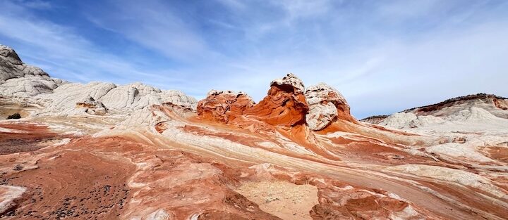
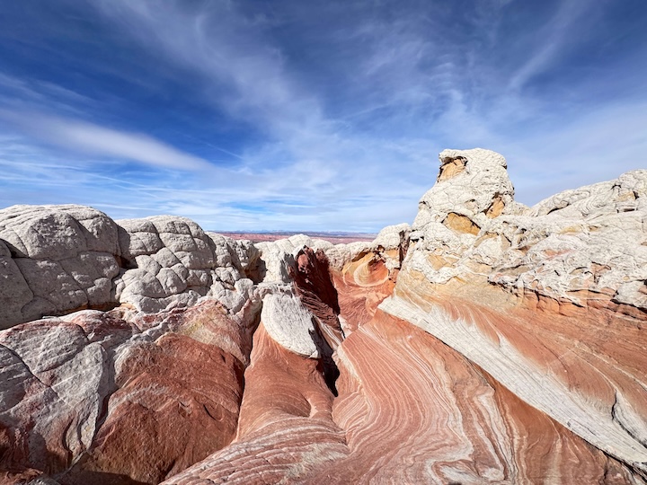
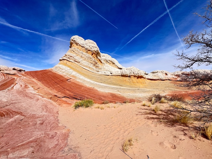
White Pocket’s geology is the result of crossbedded Navajo Sandstone in which different layers of rock with different mineral compositions were deformed and folded together. The swirling brain-coral patterns visible throughout the site are created by the different mineral content of each layer reacting differently to erosion over time. The formations at White Pocket are among the most complex and photogenic examples of this geology in the Vermilion Cliffs area.
The colors shift from bright white and soft pink to deep red and orange depending on the iron mineral content of each layer. The contrasts are highest in direct morning and late afternoon light when the color temperature of the sun emphasizes the warm tones of the iron-rich rock against the cooler whites. At midday, the overhead light flattens the contrast and the formation color is less dramatic.
Exploring the Site
White Pocket is not a trail in the conventional sense. From the parking area, a short sandy path leads to the main formation area, and from there the exploration is open. 1.5 miles represents a minimum distance for seeing the primary features. Many visitors spend 3-4 hours wandering through the full extent of the rock formations, which cover a larger area than the immediate parking access suggests.
The terrain is uneven throughout: rocky ledges, soft sand, and steep-sided formation walls require good balance. The rock surfaces in the formation area are not sharp enough to be dangerous but do require attention on the descents and scrambling sections. Sturdy hiking shoes with grip are the appropriate footwear.
There is no shade in the White Pocket formation area. The white sandstone reflects heat from below and the sun hits it from above, creating a hot desert environment even in temperatures that seem mild at the parking area. Build in water stops and pace the exploration accordingly.
Photography
White Pocket is primarily a photography destination. The formations offer endless compositional variety: macro shots of the swirling brain-coral patterns, wide-angle landscape shots of the formation field against the desert sky, and mid-range detail shots of individual rock textures. Small seasonal water pools that develop in the depressions of the formations reflect the sky and add depth to wide-angle compositions.
Golden hour is the priority timing: sunrise and sunset light turns the white sandstone gold and deep orange and the red formations go almost crimson. Planning to arrive 90 minutes before sunset and staying through the color afterglow delivers the best photography window. Morning arrivals before 8 a.m. on sunny days catch the sunrise light before the overhead heat becomes the main management challenge.

Trail Difficulty and Length
White Pocket Trail is 1.5 miles with 160 feet of gain. Easy to moderate is appropriate: the terrain is not technically demanding but the uneven rock surfaces and the desert heat require preparation beyond a flat easy trail. Budget 2-4 hours for a genuine exploration of the site.
Dog Friendly?
Yes with honest caveats. Dogs are permitted on leash throughout Vermilion Cliffs NM. The sharp-edged sandstone formations in some sections can be hard on dog paws; assess as you go and redirect dogs onto sandy sections when the rock formations are rough. No shade in the formation area; summer heat is serious for dogs. Bring at least a liter of water for dogs in addition to your own supply. Keep dogs leashed at all times to protect both them and the fragile desert soil.
What to Bring
Water: minimum 3 liters per person for a 3-4 hour desert exploration with no shade and reflective rock surfaces. Snacks for the duration. Sun protection: hat, sunscreen, long-sleeve shirt in summer. Sturdy hiking footwear for the uneven rock terrain. Emergency communication device (Garmin inReach or similar) given the complete lack of cell coverage.
For photography: wide-angle, mid-range, and a macro lens if you have one for the brain-coral pattern detail. A polarizing filter manages sky and pool reflections. A tripod for the golden-hour low-light work. Extra memory cards; White Pocket produces a volume of compositions that eats storage faster than most destinations.
Best Time to Visit
Golden hour timing is the photography priority at any time of year. Sunset visits in the fall, when the low angle of the sun illuminates the formation colors most directly, are the most memorable White Pocket experience. Plan to be at the formations by 4 p.m. on an October afternoon for the peak light window.

Rules and Regulations
Vermilion Cliffs National Monument BLM rules apply. Stay on durable surfaces; do not walk on the cryptobiotic soil crust visible as dark bumpy patches between rock formations. Do not climb on delicate or thin formations that could break. No collecting rocks, plants, or artifacts. Pack out all trash. No campfires. No drones without a BLM special use permit. Leave No Trace throughout. No fees, no day-use permits required.
Where to Stay Near Page or Kanab
Page, Arizona is about 2 hours east. Kanab, Utah is about 2 hours west. Both have developed lodging. For points travelers, check available Marriott Bonvoy properties in Kanab, IHG Rewards hotels in Kanab, and Hilton Honors options in Page. Book in advance for spring and fall when Colorado Plateau tourism peaks.
Camping Nearby
BLM dispersed camping is permitted throughout Vermilion Cliffs National Monument outside the White Pocket formation area itself. House Rock Valley Road corridor has established dispersed camping areas. Standard rules apply: pack in, pack out, 14-day stay limit. Camping at White Pocket the night before allows a sunrise start in the formations before the heat builds.
Nearby Adventures
Coyote Buttes South is 3.9 miles with 495 feet of gain from the Cottonwood Teepees Trailhead. It’s accessible from House Rock Valley Road in the same general corridor as White Pocket and offers colorful formation hiking with a BLM permit required (advance lottery system). Different permit requirements from The Wave in Coyote Buttes North.
Buckskin Gulch to Edmaier’s Secret via Wire Pass is the other major Vermilion Cliffs route. Buckskin Gulch via Wire Pass is the premier slot canyon option in the same monument at 5.5 miles.
Page, Arizona provides access to Horseshoe Bend, Dam Overlook Trail, Glen Canyon Bridge, Hanging Garden Trail, and Antelope Canyon guided tours. A White Pocket day pairs naturally with Page stops given the 2-hour proximity.
Plan This Hike
AllTrails has White Pocket mapped with the GPS track for both the access roads and the formation exploration area. Download everything before leaving Kanab or Page. Plan your visit on AllTrails and pull the offline map while you’ve got signal.
Chase the Quiet
The Wave is 17 miles south of White Pocket in the same Navajo Sandstone formation. The Wave requires a permit lottery that tens of thousands of people enter each year for a few hundred daily slots. White Pocket does not require a permit. It requires a capable vehicle and a willingness to drive on sand roads for two hours to reach a remote area with no facilities. In exchange, you get formations that rival anything the lottery-protected area offers, with the space and time to be in them properly. That’s the trade the Colorado Plateau keeps making available to anyone willing to meet it on its own terms.
Support the Adventure
To make your walls less boring, check out my photography portfolio and bring a piece of the wild and my story into your home.
If you’d like to fuel future adventures, you can donate a coffee on Ko-Fi. Every cup keeps me chasing sunrises and stories.
When you shop using my affiliate links, every click helps support this blog at no extra cost to you. It’s a small way to keep Unicorn Adventure alive and kicking while I keep exploring.
Subscribe to my mailing list for future updates, new stories, and behind-the-scenes adventures.
Stay connected with me on Instagram and Facebook for more photos and daily inspiration.
Thanks for being part of the journey, Unicorn Squadron!

Theo Maynard is a landscape photographer and adventure blogger based in Salt Lake City. He chases remote desert and mountain light across the American West, documents it all solo, and shares the journey through Unicorn Adventure. He’s on the autism spectrum, and that’s not a footnote, it’s the whole story. He creates to inspire others to get outside, chase what lights them up, and live their best possible life. Unapologetically himself.