Buckskin Gulch is one of the longest and deepest slot canyons on Earth. From the Wire Pass Trailhead, the approach through Wire Pass itself is a short slot canyon preview before the main event: the confluence with Buckskin Gulch, where the walls rise to 500 feet above and the canyon narrows to a few feet wide in sections. The 5.5-mile roundtrip to the Paria River confluence and back is the standard day-hike version of a canyon that backpackers spend multiple days traversing end to end.
I’ve hiked Wire Pass to the Buckskin Gulch confluence as a day hike from Kanab, which sits about 45 miles west on US-89 and House Rock Valley Road. The drive in on House Rock Valley Road is part of the commitment: dirt road, remote, and condition-dependent. The trailhead is well-established and the permit system is straightforward, but this is a serious canyon with serious flash flood risk, and that reality has to be part of every planning conversation for this trail. Buckskin Gulch in full, with light filtering down through 500-foot walls from directly above, is one of the more visceral sensory experiences I’ve had in the American Southwest.
Quick Facts
|
Trail Name |
Wire Pass to Buckskin Gulch |
|
Location |
Paria Canyon-Vermilion Cliffs Wilderness Area, near Kanab, Utah |
|
Coordinates |
37.0200 N, 112.0288 W (Wire Pass Trailhead) |
|
Distance |
~5.5 miles roundtrip to Paria confluence |
|
Elevation Gain |
~430 feet |
|
Difficulty |
Moderate (flash flood risk is the primary hazard) |
|
Time |
4-6 hours |
|
Dogs Allowed |
Yes, on leash; tight sections challenge larger dogs |
|
Fee |
Day use permit required; fee paid at self-serve kiosk at trailhead |
How to Get There
From Kanab, head east on US-89 for approximately 37 miles. Turn right onto House Rock Valley Road. Follow House Rock Valley Road approximately 8.3 miles to the Wire Pass Trailhead. The road is generally passable for most vehicles in dry conditions but becomes difficult or impassable after rain. Check current road conditions with the BLM Arizona Strip Field Office before making the drive.
From Page, Arizona, about 30 miles east, take US-89 west to House Rock Valley Road. From Salt Lake City, plan about 4.5 hours to Kanab plus the drive to the trailhead. From Las Vegas, roughly 3 hours north and east.
A day use permit is required and can be obtained via QR code at the self-serve kiosk at the Wire Pass Trailhead. No advance reservation required for day hiking at Wire Pass; pay at the trailhead. Overnight trips in the Paria Canyon-Vermilion Cliffs Wilderness require a different permit process through the BLM.
Parking Information
The Wire Pass Trailhead has a designated parking area that can fill on spring and fall weekends when the canyon draws its peak traffic. Arrive early on busy days. Restrooms and informational signage at the trailhead. The day use permit fee is paid via the self-serve QR kiosk.
Cell Service and Navigation
Cell coverage is absent at the Wire Pass Trailhead and throughout the canyon system. Download AllTrails offline and the BLM Paria Canyon map before leaving Kanab. The route through Wire Pass into Buckskin Gulch is essentially self-navigating, the canyon walls guide you, but having GPS active is useful for tracking your position relative to the Paria confluence turnaround point.
Flash flood weather monitoring is the critical pre-hike navigation task. Check weather forecasts for the entire Colorado Plateau upstream of the canyon, not just local Kanab conditions. A storm anywhere in the upstream watershed can send water through Buckskin Gulch without warning. The BLM website and weather.gov both provide watershed-level forecasts. Do not enter the canyon if there is any meaningful storm possibility within the upstream drainage.
What to Expect on Wire Pass to Buckskin Gulch
Wire Pass
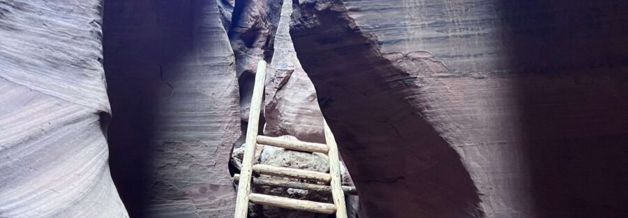
The hike from the parking area enters Wire Pass almost immediately, a narrow slot canyon that serves as the approach corridor to the main event. Wire Pass is dramatic in its own right: walls rising on both sides, Navajo Sandstone carved smooth by water, the light overhead reduced to a strip of sky. It’s a preview of the scale and character of Buckskin Gulch, shorter and somewhat less intense but genuinely beautiful.
The passage through Wire Pass involves some rock scrambling and occasional water pools depending on season and recent precipitation. Boots or shoes that can handle wet rocky terrain are the correct footwear choice.
Buckskin Gulch
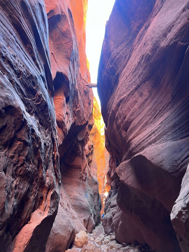
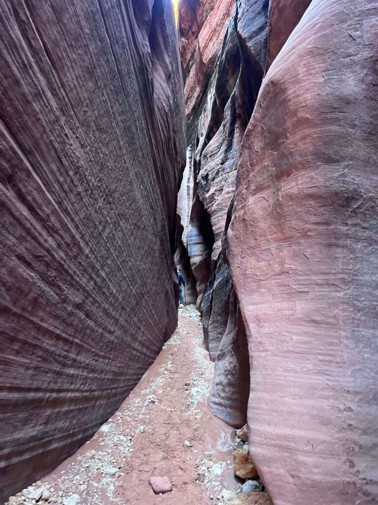
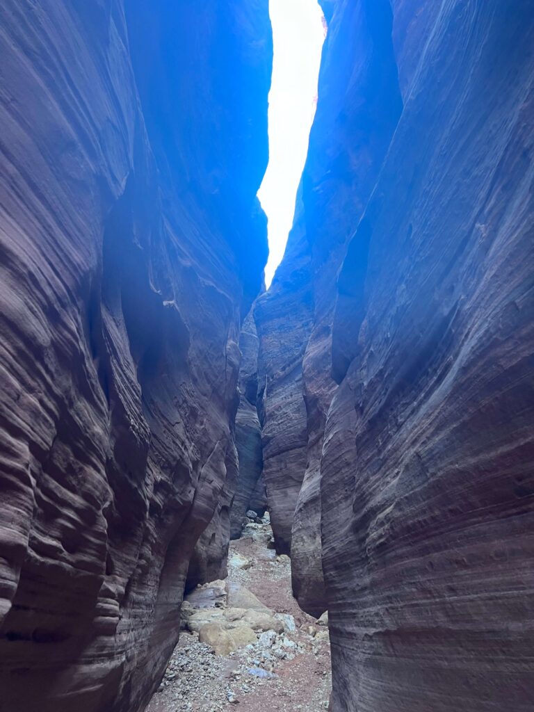
The confluence of Wire Pass and Buckskin Gulch is where the hike shifts from impressive to extraordinary. Buckskin Gulch is the longest slot canyon in the United States at roughly 13 miles end-to-end, and one of the deepest in the world, with walls reaching 500 feet above the narrow floor. The day hike version from Wire Pass explores the nearest portion of the gulch before turning around at the Paria River confluence.
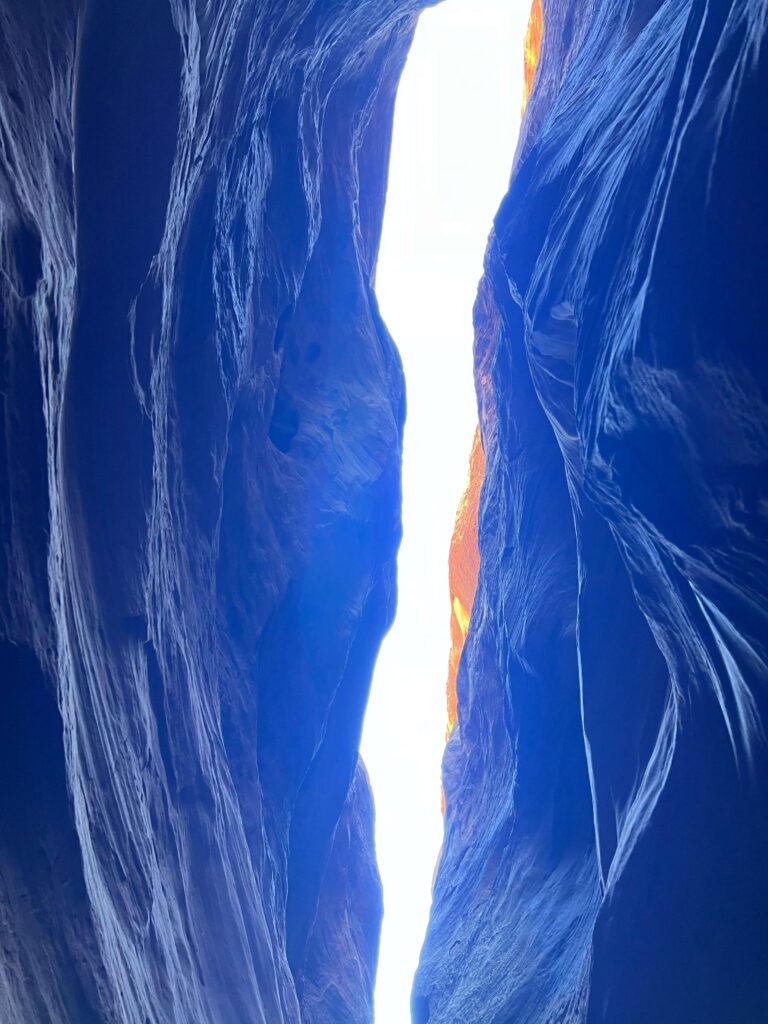
Inside Buckskin Gulch, the walls are so close and so high that the sky is visible only as a thin strip far overhead. The light that reaches the canyon floor is indirect, filtered through hundreds of feet of canyon wall, and the color of the sandstone shifts with the angle of that light throughout the day. The walls themselves show the wave-like erosion patterns characteristic of Navajo Sandstone slot canyons: smooth, curving, layered in reds and oranges and tans.
There are sections where water pools collect, ranging from ankle-deep to chest-deep depending on season and recent precipitation. Expect to get wet in some conditions. The original post’s description of possible wading is accurate. On a dry year in fall, pools may be shallow. After a wet period, sections can be thigh-deep. Know current conditions before committing to the route.
Trail Difficulty and Length
Wire Pass to Buckskin Gulch is 5.5 miles with 430 feet of gain. Moderate is accurate for the terrain and distance, with the important caveat that flash flood risk elevates the actual hazard level significantly above what a terrain-only moderate rating suggests. This is not a trail where difficulty is about your fitness. It’s about the weather in a 100-mile radius of where you’re standing.
Budget 4-6 hours for the roundtrip to the Paria confluence at a comfortable pace with time inside the gulch. Some hikers turn around before the full confluence distance; any distance into Buckskin Gulch is worth the drive out on House Rock Valley Road.
Dog Friendly?
Yes, leashed dogs are permitted. The narrow sections of Buckskin Gulch can be tight for larger dogs and the scrambling sections in Wire Pass require dogs to be physically capable of uneven rocky terrain. Water pools in the gulch may be too deep for small dogs to navigate without being carried. Assess your dog’s swimming ability and size relative to the slot canyon dimensions before committing.
Bring water for dogs independent of the canyon pools, which should not be the primary water source for any member of your party.
What to Bring
Water: 3 liters minimum. Footwear appropriate for wet rocky terrain, either waterproof hiking boots or trail runners you accept will get wet. Layers: the canyon is significantly cooler than the desert above even in summer, and wind funnels through the narrow sections. A rain jacket is worth having.
Flash flood contingency: know your exit options and how long it takes to clear the canyon at various points on the route. Have a plan if you hear water or see the sky darkening upstream. The answer is always to move toward the walls where there are footholds to climb out of the water channel, not deeper into the canyon.
For photography: a wide-angle lens for the canyon walls and the sky overhead, a mid-range for the sandstone detail and color, a tripod for the low-light interior work. The light inside Buckskin Gulch is some of the most distinctive in the canyon country of the American Southwest.
Best Time to Hike Wire Pass to Buckskin Gulch
Spring (March through May) and fall (September through November) are the best windows for temperature and manageable canyon conditions. Summer flash flood risk is at its highest during the monsoon season in July and August, when daily afternoon storms are common across the Colorado Plateau upstream drainage. Spring and fall have lower storm frequency but flash floods remain possible year-round and must be monitored.
Never hike this trail based on local Kanab weather only. The storm that fills Buckskin Gulch may be happening 50 miles away in the Colorado Plateau drainage. Check weather.gov for the Paria River watershed before every visit.
For photography, morning light from the east angles into the upper sections of Buckskin Gulch as the sun rises. The moving quality of that light as it slowly reaches deeper into the canyon over the morning hours is the specific photographic experience that makes this one of the most-photographed slot canyon destinations in the American West.
Rules and Regulations
Day use permit required, paid at the Wire Pass Trailhead self-serve kiosk. Overnight permits require separate BLM advance booking. Leave No Trace principles apply throughout. Do not touch or damage the canyon walls. No new cairns or trail marking. Flash flood weather check is a safety obligation you enforce on yourself; the BLM does not close the canyon for every upstream storm, but it’s your responsibility to not enter under dangerous conditions.
Dogs on leash. Pack out all waste including dog waste. No camping at the Wire Pass Trailhead.
Where to Stay Near Kanab
Kanab is about 45 miles west via US-89. Basecamp37 in Kanab is worth knowing about. For points travelers, check available Marriott Bonvoy properties in Kanab, IHG Rewards hotels in Kanab, and Hilton Honors options near Kanab. Page, Arizona, is 30 miles east on US-89 and serves as an alternative base with additional lodging options.
Camping Nearby
The Wire Pass Trailhead area has dispersed camping. Camping inside the Paria Canyon-Vermilion Cliffs Wilderness requires a separate overnight permit through the BLM Arizona Strip Field Office. Kanab and Page have developed private campgrounds for those wanting facilities.
Nearby Adventures
Buckskin Gulch to Edmaier’s Secret via Wire Pass is a separate route through the Vermilion Cliffs NM, the longer version of the same corridor beyond what a standard Wire Pass day hike covers.
Peekaboo Slot Canyon, accessible from Angel Canyon Road off US-89 north of Kanab, is another Kanab-area slot canyon at 7.5 miles. A different character, less depth and narrowness than Buckskin Gulch, but accessible without a permit.
The Wave in Coyote Buttes North is accessible from the House Rock Valley Road corridor (the same road used to reach Wire Pass). The Wave requires an extremely competitive permit lottery and is a separate planning commitment from the Buckskin Gulch day hike. Worth pursuing alongside any House Rock Valley Road trip if you have the timing.
The Nautilus, Great Chamber, Sand Caves, and Belly of the Dragon round out the Kanab-area options for anyone building a multi-day southern Utah itinerary around this corridor.
Plan This Hike
AllTrails has Wire Pass to Buckskin Gulch mapped with the route, offline GPS tracking, and recent condition reports including water level notes from hikers. The condition reports are the most valuable tool for this trail: they tell you current pool depths, any flash flood damage, and road conditions on House Rock Valley Road. Plan your hike on AllTrails and pull the offline map while you’ve got signal in Kanab.
Chase the Quiet
Buckskin Gulch at 500 feet of wall and a few feet of sky overhead is not quiet in the conventional sense. The sound of your footsteps echoes. Water dripping somewhere deep in the canyon amplifies. Wind funnels through the slot and changes pitch as the width changes. It’s a specific kind of enclosed sound environment that doesn’t exist anywhere else quite the way it does here. The quiet is the absence of the human world above the canyon rim. Down in the gulch, the desert just sounds like itself, and it sounds enormous.
Support the Adventure
To make your walls less boring, check out my photography portfolio and bring a piece of the wild and my story into your home.
If you’d like to fuel future adventures, you can donate a coffee on Ko-Fi. Every cup keeps me chasing sunrises and stories.
When you shop using my affiliate links, every click helps support this blog at no extra cost to you. It’s a small way to keep Unicorn Adventure alive and kicking while I keep exploring.
Subscribe to my mailing list for future updates, new stories, and behind-the-scenes adventures.
Stay connected with me on Instagram and Facebook for more photos and daily inspiration.
Thanks for being part of the journey, Unicorn Squadron!

Theo Maynard is a landscape photographer and adventure blogger based in Salt Lake City. He chases remote desert and mountain light across the American West, documents it all solo, and shares the journey through Unicorn Adventure. He’s on the autism spectrum, and that’s not a footnote, it’s the whole story. He creates to inspire others to get outside, chase what lights them up, and live their best possible life. Unapologetically himself.