

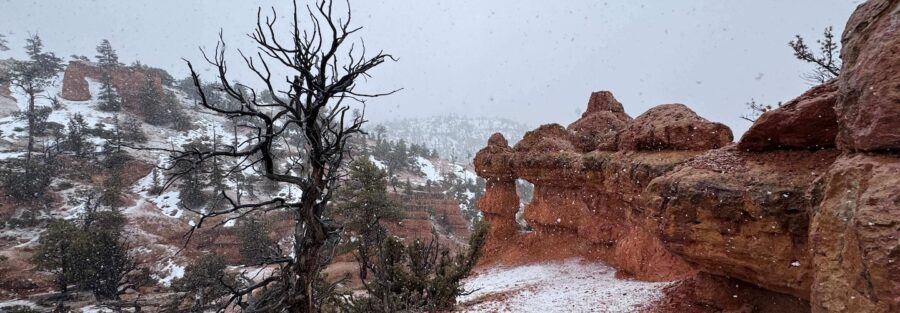
Most people drive through Red Canyon on their way to Bryce Canyon National Park and barely slow down. That’s a mistake. The Arches Trail in Dixie National Forest sits right off Highway 12, a half mile from the road, and it earns more per foot of hiking than almost anything in southern Utah. Natural arches, hoodoos the color of brick and rust, and a trail quiet enough to hear the wind.
Quick Facts
| Trail Name | Arches Trail |
| Location | Red Canyon, Dixie National Forest, Utah (near Panguitch) |
| Coordinates | 37.7718 N, 112.3389 W |
| Distance | 0.6 miles (out-and-back) |
| Elevation Gain | 187 feet |
| Difficulty | Moderate |
| Time | 30–60 minutes |
| Dogs Allowed | Yes, on leash |
| Fee | No fee required for Dixie National Forest trails (Red Canyon day use area may collect fees seasonally, verify on-site) |
| View on Alltrails | |
How to Get There
The Arches Trailhead is in Red Canyon, inside Dixie National Forest, about 10 miles east of Panguitch on Highway 12. The Red Canyon Visitor Center is your landmark. The trailhead is signed and sits just off the highway, easy to spot.
From Panguitch: Head east on Highway 12. After about 10 miles you’ll enter Red Canyon, the area identifiable by the tunnels carved through red rock formations. The Red Canyon Visitor Center is on the right. Park there and follow signs to the Arches Trailhead, a short walk from the lot.
From Bryce Canyon National Park: Head west on Highway 12 from the park entrance. Red Canyon and the visitor center are about 8 miles from the park boundary. It’s a natural add-on at the start or end of a Bryce day.
From Kanab: Head north on US-89, then west on Highway 12. Total drive is about an hour. Kanab also makes a good base for combining this hike with nearby slot canyon options to the south.
Parking Information
Park at the Red Canyon Visitor Center lot, a large paved area with restrooms and water. The Arches Trailhead is a short signed walk from the lot. Parking fills up on summer weekends by mid-morning. Arriving before 9 a.m. keeps your options open.
No permit required. The visitor center has bathrooms and is worth a quick stop for current trail conditions. Red Canyon is a Dixie National Forest day use area and may collect a small fee during peak season. Verify on-site or check the Dixie National Forest website before your visit.

Cell Service and Navigation
Cell service along Highway 12 and in Red Canyon is inconsistent. Some carriers get usable signal near the visitor center. Once you’re on trail, don’t count on it.
The Arches Trail is short and well-signed, so navigation isn’t a real concern. Still, download the area offline in AllTrails before you go. It takes thirty seconds and removes any variable. Good habit for any trail in southern Utah.
What to Expect on the Arches Trail
The Trail
The trail heads away from the visitor center into a canyon landscape dominated by red and pink Claron Formation limestone, the same rock type responsible for Bryce Canyon’s hoodoos. The formations here are denser and closer to the trail than anything you’ll see from a national park overlook. You’re in among them, not looking at them from a distance.
The path is well-maintained, with some sandy sections and a few rocky stretches on the ascent. The grade is steady but manageable. Most hikers are comfortable doing this without trekking poles, but they don’t hurt on the steeper sections.
The Arches
The namesake arches appear within the first quarter mile. These are naturally formed limestone arches, eroded from the surrounding rock over millions of years. The main arch sits above the trail at a viewable angle, large enough to frame the sky beyond it. A second smaller arch appears further along before the trail reaches its turnaround.
Morning light hits the east-facing walls of the canyon and lights up the red rock in a way that makes every composition easy. Late afternoon can work too, depending on time of year. Midday is the least interesting light but the arches don’t need much help.
Trail Difficulty and Length
The Arches Trail is 0.6 miles out-and-back with 187 feet of elevation gain. Listed as moderate, which reflects the grade of the ascent rather than any technical challenge. There’s nothing technical here. The trail is accessible for most hikers, including families with kids old enough to handle some uphill.
Thirty to sixty minutes covers it comfortably. Longer if you’re stopping to photograph or spending time at the arches. It’s a hike you can do before breakfast without disrupting the rest of your day.

Dog Friendly?
Yes. The Arches Trail is dog-friendly. Dogs must be on a leash at all times. The sandy and rocky terrain is manageable for most dogs, but check paw conditions on hot summer days. Temps in Red Canyon can run into the 90s in July and August. Hot rock and sand on bare paws is a real concern.
Bring enough water for your dog. The visitor center has water available, but once you’re on trail there’s nothing. A collapsible bowl and a spare liter solves this.
What to Bring
Short trail, but southern Utah is unforgiving in summer. Sun exposure in Red Canyon is full and direct. Bring sunscreen, a hat, and sunglasses even for a thirty-minute hike.
Water for yourself and your dog. A liter per person is more than enough for this length, but pack it. The terrain is rocky in sections and trail runners or light hikers work well. Heavy boots are overkill.
Best Time to Hike the Arches Trail
Spring and fall are the sweet spots. April through June and September through October bring comfortable temperatures and the kind of light that makes red rock photography easy. The canyon is accessible year-round but summer midday can push into the 90s. Early morning starts solve that.
For photography, aim for the first two hours after sunrise. The light comes over the canyon rim and hits the formations at a low angle, bringing out the texture and depth of the rock. The arch catches direct light early and you can work it from multiple angles before the shadows shift.
Winter visits are possible. The trail stays snow-free in most mild conditions, and the red rock against snow is genuinely striking. Check road conditions on Highway 12 before making the drive in December through February.
Rules and Regulations
The Arches Trail sits in Dixie National Forest, not a national park. No entrance fee is required for forest access, though the Red Canyon day use area may collect fees seasonally. Verify current fee status before your visit at the Dixie National Forest website or call the Powell Ranger District office in Panguitch.
Leave No Trace applies. Pack out all trash, stay on the designated trail, and don’t climb on or disturb the arches or any rock formations. These features are irreplaceable and more fragile than they look.
Dogs must be leashed at all times. Clean up after your pet.
Where to Stay Near Red Canyon
Panguitch is the closest town to Red Canyon, about 10 miles west on Highway 12. It has a handful of motels and local lodging options convenient for an early start.
For Marriott stays, search Marriott Bonvoy properties in Cedar City, about 55 miles northwest on I-15. Cedar City is the closest city with reliable chain hotel options and works well as a base for Red Canyon, Bryce, and Cedar Breaks.
IHG Rewards members can check IHG properties in Cedar City or St. George for points redemption. Both cities have properties and put you within reasonable driving distance of southern Utah’s best hiking.
Hilton Honors travelers should search Hilton properties in St. George, about two hours southwest. A solid base for combining Red Canyon with Zion and the surrounding area.
Kanab, about an hour south on US-89, is another good option if you’re combining Red Canyon with slot canyons in the Kanab area. Budget-friendly motels and a growing number of boutique stays.
Camping Nearby
Red Canyon Campground in Dixie National Forest is the closest option, right inside the canyon adjacent to the trail area. It’s a developed campground with basic amenities and a no-frills atmosphere that suits the terrain. Book through Recreation.gov during peak season, especially summer weekends.
Hitch-N-Post Campground in Panguitch is a private option with hookups and more amenities, closer to town services. Useful if you need laundry, showers, or a reliable cell signal.
Dispersed camping is available throughout Dixie National Forest outside designated campground areas. Pull the Dixie National Forest motor vehicle use map and look for forest roads branching off Highway 12 and surrounding routes. Check with the Powell Ranger District in Panguitch for current dispersed camping rules and fire restrictions.
Nearby Adventures
The Golden Wall/Buckhorn Loop is the bigger objective in Red Canyon, 4.7 miles with 1,056 feet of gain. Longer and more demanding than the Arches Trail, it delivers expansive canyon views and sustained red rock terrain. A natural second act if you want more mileage.
Just 10 miles east, Bryce Canyon National Park offers world-class hoodoo terrain. The Tower Bridge Trail (3.6 miles, 839 feet of gain) and the Rainbow Point and Bristlecone Loop (1.3 miles, 118 feet of gain) are both recently rewritten on this site and make excellent day companions.
Panguitch itself is worth a walk. The historic district on Main Street has well-preserved brick commercial buildings from the early 1900s. Small-town Utah in the best sense. Grab food at one of the local diners before or after the trail.
Panguitch Lake, about 15 miles west of town on Highway 143, is a high-elevation reservoir open for fishing, boating, and picnicking. A good cooldown option after a hot afternoon hike.
Plan This Hike
Get trail maps, current conditions, user reviews, and offline downloads for the Arches Trail on AllTrails: View on Alltrails.
AllTrails is the tool I use to prep every hike. Offline maps matter anywhere cell service is uncertain, and the review feed shows you condition reports from the last week rather than the last year. Worth running before you drive out.
Chase the Quiet
This hike is thirty minutes on paper and half a day in practice. Not because it’s hard. Because it’s the kind of place that makes you slow down. You walk out from the visitor center, and within five minutes the highway noise drops off and you’re just in the canyon with the rock and the light. That’s the whole thing. That’s enough.
Support the Adventure
To make your walls less boring, check out my photography portfolio and bring a piece of the wild and my story into your home.
If you’d like to fuel future adventures, you can donate a coffee on Ko-Fi. Every cup keeps me chasing sunrises and stories.
When you shop using my affiliate links, every click helps support this blog at no extra cost to you. It’s a small way to keep Unicorn Adventure alive and kicking while I keep exploring.
Subscribe to my mailing list for future updates, new stories, and behind-the-scenes adventures.
Stay connected with me on Instagram and Facebook for more photos and daily inspiration.
Thanks for being part of the journey, Unicorn Squadron!

Theo Maynard is a landscape photographer and adventure blogger based in Salt Lake City. He chases remote desert and mountain light across the American West, documents it all solo, and shares the journey through Unicorn Adventure. He’s on the autism spectrum, and that’s not a footnote, it’s the whole story. He creates to inspire others to get outside, chase what lights them up, and live their best possible life. Unapologetically himself.