


Four miles. Eighteen hundred feet of elevation gain. At the top, Lake Tahoe spread out below in every direction you can see it, deep blue surrounded by granite peaks, with Desolation Wilderness filling the western skyline. Granite Lake and Maggie’s Peak is not a casual hike. It earns the view through a mile of moderate pine forest, an alpine lake stop, and then another mile of increasingly steep rocky switchbacks to the summit. Every foot of that climb is justified by what you see from the top. Alpine summit hikes have a specific reward structure I respond to strongly. The summit is finite and clear. The view is the payoff and it arrives all at once. Estes was in the Bayview Campground lot before sunrise and I was on the Maggie’s Peak summit by mid-morning with the whole lake below me and nobody else on the ridge. That’s the move.
Quick Facts
| Trail Name | Granite Lake and Maggie’s Peak via Bayview Trail |
| Location | Desolation Wilderness, South Lake Tahoe, California |
| Coordinates | 38.9439, -120.0996 (Bayview Campground Trailhead) |
| Distance | 4 miles (out and back) |
| Elevation Gain | 1,800 ft |
| Difficulty | Hard |
| Time | 5 hours |
| Dogs Allowed | Yes, on leash |
| Fee | Free day-use wilderness permit required; self-issue at trailhead or online at recreation.gov |
| Plan This Hike on AllTrails | |
How to Get There
The Bayview Campground Trailhead sits on Highway 89 just north of Emerald Bay, about 15 to 20 minutes from South Lake Tahoe. From South Lake Tahoe, drive northwest on US-50 and turn north on Highway 89. Follow it along the lake shore through the Emerald Bay corridor until you see the Bayview Campground sign on the right. The campground entrance and trailhead are well-marked. From the north side of the lake, Highway 89 takes you south through Tahoe City and along the western shore directly to Bayview.
Parking Information
Parking is available at the Bayview Campground lot at no charge. No parking fee, but a Desolation Wilderness day-use permit is required. Day-use permits are free and available at a self-issue station at the trailhead or in advance at recreation.gov. Overnight permits must be reserved in advance and have a fee. The lot fills quickly on summer weekends. Arrive before 8 a.m. to secure a spot. If the main lot is full, limited shoulder parking exists along Highway 89, but adds a short road walk to the trailhead. 
Cell Service and Navigation
Cell coverage along Highway 89 near Emerald Bay is inconsistent. Signal drops in the Emerald Bay canyon corridor and is unreliable on the upper trail above Granite Lake. Download the AllTrails map offline before leaving South Lake Tahoe. The trail to Granite Lake is well-marked. The route from Granite Lake to Maggie’s Peak is steeper and less defined in sections, making a GPS track useful for staying on the correct line through the rocky switchbacks near the summit.
What to Expect on Granite Lake and Maggie’s Peak
The Forest Approach
The trail begins in pine forest immediately at the Bayview Campground trailhead, climbing steadily through a mix of Jeffrey pine, white fir, and manzanita with intermittent views of Lake Tahoe through the trees as you gain elevation. The first mile is the most gradual section of the hike. The trail is well-maintained and the footing is solid on packed dirt and exposed granite slabs. You cover a moderate amount of elevation in the first mile without the sustained steepness that comes above Granite Lake.
Granite Lake
Granite Lake appears at roughly the one-mile mark, a compact alpine lake set beneath granite cliffs with clear water and the kind of stillness that feels intentional. It is a good rest stop before the hard section starts. The lake is small enough to circumnavigate in a few minutes and the rock slabs around the shore make comfortable sitting. Refill water here if you have a filter. The lake is cold, clear, and well above the developed shoreline of Lake Tahoe. Give yourself 10 to 15 minutes here before pushing to the summit.
The Summit Climb
From Granite Lake, the trail to Maggie’s Peak gains the bulk of its elevation in the second mile. The grade steepens significantly and the trail surface shifts to loose rock and granite slab with rocky switchbacks that demand solid footwear and attention. There are sections where the route is less obvious through the boulders. The GPS track matters here. The summit itself opens suddenly after the final switchback, a granite ridge with Lake Tahoe filling the eastern horizon and Desolation Wilderness extending to the west. On clear days the view stretches across the lake to the Nevada side. Worth every step of the second mile. 
Trail Difficulty and Length
Granite Lake and Maggie’s Peak is a 4-mile out-and-back with 1,800 feet of elevation gain rated hard. The first mile to Granite Lake is moderate. The second mile to the summit is genuinely strenuous with sustained steep grade and rocky technical sections near the top. Hiking boots with ankle support are worth it over trail runners given the loose rock on the upper switchbacks. Trekking poles help on the descent. Give yourself 3 to 5 hours for the round trip at a comfortable pace. Do not rush the summit ridge descent. 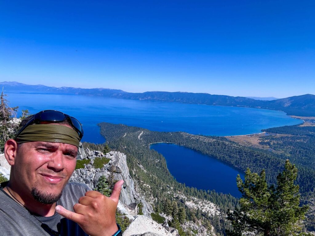
Dog Friendly?
Dogs are allowed in Desolation Wilderness and on this trail on leash. The lower forest section and Granite Lake are manageable for most dogs. The rocky upper switchbacks to the Maggie’s Peak summit are more demanding on four-legged hikers, particularly smaller breeds. Assess your dog’s agility and conditioning honestly before committing to the summit push. Bring plenty of water. No reliable water sources exist above Granite Lake. Pack out all waste.
What to Bring
At least 2 liters of water per person. More in summer. A water filter if you plan to refill at Granite Lake. Sunscreen and a hat for the exposed summit ridge. Hiking boots with ankle support and aggressive grip for the rocky upper trail. Trekking poles for the descent. Layers for the summit ridge where wind is common. Snacks for the Granite Lake stop and the summit. A camera. The Lake Tahoe panorama from Maggie’s Peak rewards a wide lens and the alpine lake stop rewards a polarizing filter on the water. 
Best Time to Hike Granite Lake and Maggie’s Peak
The trail is snow-covered from November through May in most years and the Desolation Wilderness snowpack lingers into June at the summit elevation. Late June through September is the reliable hiking window. July and August bring the most stable conditions but also the largest crowds at the Bayview trailhead. Start before 7 a.m. on summer weekends to beat the parking crunch and the afternoon thunderstorm risk that builds over the Sierra Nevada by early afternoon in summer. Early fall is the best overall timing: cooler temperatures, thinner crowds, the aspens beginning to turn in the canyon below, and the lake at its clearest blue of the year. Check current snow conditions at recreation.gov for the Desolation Wilderness zone before planning a June or late September trip.
Rules and Regulations
Granite Lake and Maggie’s Peak sit within Desolation Wilderness, managed by the USDA Forest Service. A wilderness permit is required for all visitors, including day-use. Day-use permits are free and self-issued at the trailhead kiosk or obtained in advance at recreation.gov. Overnight permits require advance reservation and a fee. No campfires anywhere in Desolation Wilderness. Camping is prohibited within 100 feet of lakes and streams. Dogs must be leashed at all times. Pack out all waste, including dog waste. Leave No Trace throughout. The wilderness designation exists to protect one of the most fragile and heavily visited alpine environments in California.
Where to Stay Near Lake Tahoe
South Lake Tahoe has the widest lodging range in the area, from lakefront resorts to budget motels along US-50. Marriott Bonvoy covers the Tahoe area with several properties. Hilton Honors has options in South Lake Tahoe and the broader Tahoe basin. The Bayview Campground itself has tent and RV sites that put you at the trailhead, worth booking in advance for summer stays.
Camping Nearby
Bayview Campground at the trailhead is the most convenient option, with developed sites on the edge of Desolation Wilderness. Book through recreation.gov. Emerald Bay State Park Campground is a short drive south with lakefront sites and boat-in camping access. For dispersed wilderness camping, overnight Desolation Wilderness permits allow camping throughout the wilderness area with the 100-foot lake and stream setback requirement and a no-campfire policy in effect. Plan and book overnight permits well in advance, Desolation Wilderness overnight slots fill months ahead in summer.
Nearby Adventures
The Eagle Lake Trail from the Eagle Falls Trailhead is the most popular nearby short hike, under a mile to an alpine lake with a short walk to the Eagle Falls viewpoint alongside it. Vikingsholm at Emerald Bay is a Scandinavian-style mansion accessible by a steep 1-mile trail from the Emerald Bay overlook parking, one of the most unusual cultural stops in California State Parks. The Mount Tallac Trail near Fallen Leaf Lake is the full-day summit option in this section of Desolation Wilderness, a 9,735-foot summit with one of the best high-elevation Lake Tahoe views in the basin. Emerald Bay boat tours and kayak rentals put you on the water for a different perspective on the same landscape you’ve just hiked above. South Lake Tahoe’s lakefront restaurants and the Stateline casino corridor are the post-hike infrastructure options for anyone who wants them.
Plan This Hike
AllTrails has Granite Lake and Maggie’s Peak documented with GPS track, current conditions from recent hikers, and notes on the upper rocky switchback sections where the route-finding matters. Download the offline map before leaving South Lake Tahoe. Obtain your Desolation Wilderness day-use permit at recreation.gov or at the trailhead self-issue station before starting. Plan your hike on AllTrails here.
Chase the Quiet
Maggie’s Peak summit at 8 a.m. on a Wednesday in September. Lake Tahoe below in every direction it’s visible, the water that particular deep blue it only hits when the summer crowds have thinned and the angle of the light changes toward fall. Desolation Wilderness to the west, granite peaks in every direction, and enough quiet that the wind off the summit ridge was the loudest thing happening. That’s the version of this hike worth getting up early for. The 1,800 feet earns it completely.
Support the Adventure
To make your walls less boring, check out my photography portfolio and bring a piece of the wild and my story into your home. If you’d like to fuel future adventures, you can donate a coffee on Ko-Fi. Every cup keeps me chasing sunrises and stories. When you shop using my affiliate links, every click helps support this blog at no extra cost to you. It’s a small way to keep Unicorn Adventure alive and kicking while I keep exploring. Subscribe to my mailing list for future updates, new stories, and behind-the-scenes adventures.

Theo Maynard is a landscape photographer and adventure blogger based in Salt Lake City. He chases remote desert and mountain light across the American West, documents it all solo, and shares the journey through Unicorn Adventure. He’s on the autism spectrum, and that’s not a footnote, it’s the whole story. He creates to inspire others to get outside, chase what lights them up, and live their best possible life. Unapologetically himself.