Capitol Reef National Park doesn’t get the attention it deserves. It sits between Bryce and Arches on the map, and most Utah road trips treat it as a gas stop between bigger names. That’s a mistake. Cassidy Arch Trail is one of the reasons. Three miles, 700 feet of gain, and at the top you can walk out onto a natural stone arch and look down into Grand Wash from a vantage point most people never find.
The sensory experience of a place like Capitol Reef, the scale, the silence, the way the light moves across the rock, does something for me that’s hard to put into words and easy to chase. This trail is part of why I keep coming back to southern Utah.
Here’s everything you need to hike it right.
Quick Facts
|
Trail Name |
Cassidy Arch Trail |
|
Location |
Capitol Reef National Park, Utah (near Torrey) |
|
Coordinates |
|
|
Distance |
3.0 miles (out-and-back) |
|
Elevation Gain |
700 feet |
|
Difficulty |
Moderate |
|
Time |
2-3 hours |
|
Dogs Allowed |
No |
|
Fee |
Capitol Reef entrance fee ($20/vehicle; America the Beautiful pass accepted) |
|
AllTrails |
How to Get There
Capitol Reef National Park sits along Utah State Route 24, about 11 miles east of Torrey and roughly 220 miles south of Salt Lake City. The park is less than four hours from SLC and about three hours from Moab.
From Salt Lake City: Head south on I-15 to US-6 East, then south on US-89 through Richfield. Pick up UT-24 East through Torrey and into the park. Follow the Scenic Drive south from the visitor center for about 3.5 miles, then turn onto Grand Wash Road. The Cassidy Arch Trailhead is 1.2 miles down that dirt road.
From Moab: Head west on UT-128 and US-191, then take UT-24 West through Hanksville and into the park from the east. About three hours. The Scenic Drive entrance is just south of the visitor center on your right.
From Bryce Canyon: Head north on UT-63 and US-89, then east on UT-24 through Torrey. About two hours. Capitol Reef makes a natural next stop after a Bryce trip.
Grand Wash Road is unpaved but generally passable for standard vehicles in dry conditions. High clearance is not required. Check NPS road conditions before your visit after rain or snow.
Parking Information
Park at the Grand Wash Trailhead, about 1.2 miles down Grand Wash Road off the Scenic Drive. The lot is small. Spring and fall weekends can fill it. Early arrival solves the problem. There’s no fee beyond the park entrance.
The Grand Wash Trailhead also serves the Grand Wash Trail, so the lot pulls double duty. If it’s full, limited roadside parking exists along Grand Wash Road. Don’t block the road or pull off onto fragile soil.

Cell Service and Navigation
Cell service in Capitol Reef is unreliable across most of the park. Grand Wash is a canyon environment and you’re walled in from towers. Don’t expect data or navigation once you leave the visitor center area.
The trail is well-signed from the trailhead and straightforward to follow. Download it offline in AllTrails before you leave. The Grand Wash area has enough side options that having your route confirmed on-screen is worth the thirty seconds it takes to set up.
What to Expect on Cassidy Arch Trail
The Trail
The trail starts at the Grand Wash Trailhead and heads immediately uphill. The first half mile is the sustained climb, a series of switchbacks that gain most of the elevation quickly. The footing is rocky and requires attention. This is not a trail to hike in sandals.
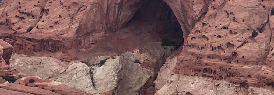
As you gain elevation, the views open up into Grand Wash below and the surrounding canyon walls. Capitol Reef’s Wingate Sandstone cliffs, those dark red vertical faces that define the park, fill the horizon on multiple sides. The scale is different from the ground than from a car window.
The trail levels off in the middle section before the final approach to the arch. The upper portion winds along the canyon rim with exposure on one side. Stay on the trail. The edge is real.

The Arch
Cassidy Arch is a freestanding natural arch named after Butch Cassidy, who is said to have used the Capitol Reef area as a hideout in the late 1800s. The arch spans roughly 150 feet and sits at the edge of the canyon rim. You can walk across the top.
This is the rare arch in Utah that you actually access from above rather than viewing from below. Most natural arches in the region are best seen from the canyon floor. Cassidy Arch inverts that. You approach from the slickrock above and the view drops away below you into Grand Wash. It’s a genuinely different experience.
The top of the arch is exposed slickrock. Take it carefully, especially if there’s any moisture on the surface. The arch itself is solid, but the approach and the views create a significant exposure sensation. Worth it. Go slow and earn it.
Trail Difficulty and Length
The Cassidy Arch Trail runs 3.0 miles out-and-back with 700 feet of elevation gain. Moderate rating. That’s accurate for a hiker in reasonable shape. The initial switchback section is the hardest part, steep and rocky, but it’s over within the first mile. The payoff at the arch is proportional to the effort.
Two to three hours covers the round trip comfortably. Longer if you spend time on the arch or shooting photography from multiple angles. Don’t rush the top. The view earns the time.
This trail is not suitable for young children or anyone with a fear of exposure. The arch approach involves slickrock and open drops. Strong hikers will find it straightforward. Anyone uncertain about heights should assess honestly before committing.

Dog Friendly?
No. Dogs are not permitted on Cassidy Arch Trail or most other trails in Capitol Reef National Park. The park restricts pets to paved areas and developed sites, on a leash no longer than six feet.
If you’re traveling with a dog, plan for them to stay at camp or in the vehicle while you hike. Capitol Reef’s campground at Fruita allows leashed pets in the campsite area. The park is not structured for dogs on trail.
What to Bring
Water is the priority. Carry at least two liters per person. Capitol Reef is high desert. The canyon terrain reflects heat and there’s no shade on the upper switchbacks or the arch approach. The park has no water sources on trail.
Sun protection at this elevation and latitude matters. Hat, sunscreen, UV layers. A light wind layer for the exposed rim sections in spring and fall. Sturdy trail shoes or hikers with grip are essential. The rocky switchback terrain and exposed slickrock on the arch require traction.
Trekking poles earn their weight on the initial climb and help on the descent when knees start to feel the rocky grade. A standard daypack handles everything this trail needs.
Camera. The arch approach from above delivers a unique angle on a natural formation that you can’t get at most Utah arch sites. Bring whatever you’d want for a landscape shoot.

Best Time to Hike Cassidy Arch Trail
Spring and fall are the prime windows. April through June and September through October deliver mild temperatures, manageable crowds, and the kind of directional light that makes Capitol Reef’s red rock pop. The park gets genuinely quiet on weekdays in shoulder season.
Summer is hikeable with an early start. On trail by 7 a.m. before the canyon heats up. Temperatures in Grand Wash can exceed 100°F by midday in July and August. The exposed switchbacks amplify heat. Plan accordingly or wait for better conditions.
For photography, the morning light hits the Wingate cliffs from the east and creates dramatic shadows across the canyon walls. The arch itself catches good light in the late morning when you’re likely to be at the top. Late afternoon works on the return descent.
Winter visits are possible. Snow on Capitol Reef’s formations is striking. The Grand Wash Road may close after significant precipitation. Trail ice can make the slickrock arch approach genuinely dangerous. Check NPS conditions before committing.
Rules and Regulations
Capitol Reef charges a $20 per vehicle entrance fee, valid for seven days. The America the Beautiful Annual Pass covers entry here and at every other national park and federal recreation site.
Stay on designated trails. Capitol Reef’s soil crust and rock formations are fragile. Off-trail movement causes damage that takes decades to reverse.
Pack out everything. Leave No Trace. No drones anywhere in the park. The park is a designated dark sky preserve, minimize artificial light at night. No fires outside designated campfire areas.
Standing on the arch is permitted and expected. The trail leads there. Just move carefully on the slickrock surface and keep awareness of the exposure. Don’t underestimate it.
Where to Stay Near Capitol Reef
Torrey, about 11 miles west of the park entrance on UT-24, is the primary lodging base for Capitol Reef. It has a good selection of independent motels, inns, and a handful of higher-end options. The town is small but functional and keeps you close to an early trailhead start.
The Rim Rock Inn and Capitol Reef Resort in Torrey are locally owned options worth booking if you want to stay close and keep your dollars in the community. Book early for spring and fall. For points travelers heading to or from the park, check available Marriott Bonvoy properties, IHG Rewards hotels, and Hilton Honors options in Salt Lake City, Moab, or Cedar City along your route.
Camping Nearby
Fruita Campground inside Capitol Reef National Park is the most convenient option, right in the park near the visitor center and Scenic Drive. It’s a developed campground with basic amenities and a limit of 71 sites. Book through Recreation.gov. It fills fast in spring and fall. First-come, first-served sites exist but are gone by morning on busy weekends.
The campground sits in the Fruita Historic District among century-old orchards. It’s one of the more pleasant developed campgrounds in the national park system. Worth making the reservation.
For dispersed camping, BLM land surrounds Capitol Reef on multiple sides. The San Rafael Swell to the north and the Dixie National Forest land near Torrey both offer dispersed options. Pull the BLM motor vehicle use map for the area and look for established camping zones. Check current fire restrictions before heading out.
Nearby Adventures
The Grand Wash Trail shares the trailhead with Cassidy Arch and runs through the canyon floor below where you just hiked. It’s an easy walk through a narrow canyon with towering Wingate walls and a completely different perspective on the terrain. A natural add-on on the same day.
The Fruita Historic District is a short drive from the trailhead and worth the stop. The park maintains historic orchards planted by early Mormon settlers. In season, you can pick fruit directly from the trees, cherries, apricots, peaches, apples, and pears depending on the month. The Gifford Homestead nearby sells pies and local goods. This is the kind of thing that doesn’t exist anywhere else in the national park system.
Hickman Bridge Trail (1.7 miles, 400 feet of gain) is another strong option in Capitol Reef, one of the park’s most accessible natural arch hikes. It starts near the visitor center and is worth pairing with a Cassidy Arch day if you have legs left.
Capitol Reef is a natural midpoint between Bryce Canyon and Arches on a southern Utah loop. The Wall Street, Queens Garden, and Peekaboo Loop at Bryce (6.3 miles, 1,499 feet of gain) and the full Arches National Park terrain are both within a two to three hour drive and make logical legs of the same trip. The full Bryce Canyon trail catalog extends the options.
Capitol Reef is a designated International Dark Sky Park. The park’s remote location and low surrounding population density create exceptional stargazing conditions. If you’re there overnight, stay up past midnight. The Milky Way is visible with the naked eye.
Plan This Hike
Get turn-by-turn directions, trail conditions, user reviews, and offline map downloads for Cassidy Arch Trail on AllTrails: View on AllTrails.
Offline maps matter in Capitol Reef. Download before you leave. AllTrails condition reports from the last week will tell you whether Grand Wash Road is passable and whether there’s ice on the arch approach. Worth the two minutes it takes to check.
Chase the Quiet
Standing on top of Cassidy Arch with Grand Wash dropping away below me and nobody else in sight, that’s the whole thing distilled. Capitol Reef doesn’t have the marketing machine that Arches and Zion do. It doesn’t need one. The people who find it come back. The people who skip it see the postcards later and wonder why they didn’t stop.
Support the Adventure
To make your walls less boring, check out my photography portfolio and bring a piece of the wild and my story into your home.
If you’d like to fuel future adventures, you can donate a coffee on Ko-Fi. Every cup keeps me chasing sunrises and stories.
When you shop using my affiliate links, every click helps support this blog at no extra cost to you. It’s a small way to keep Unicorn Adventure alive and kicking while I keep exploring.
Subscribe to my mailing list for future updates, new stories, and behind-the-scenes adventures.
Stay connected with me on Instagram and Facebook for more photos and daily inspiration.
Thanks for being part of the journey, Unicorn Squadron!

Theo Maynard is a landscape photographer and adventure blogger based in Salt Lake City. He chases remote desert and mountain light across the American West, documents it all solo, and shares the journey through Unicorn Adventure. He’s on the autism spectrum, and that’s not a footnote, it’s the whole story. He creates to inspire others to get outside, chase what lights them up, and live their best possible life. Unapologetically himself.