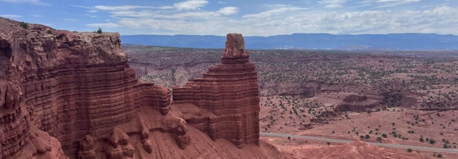
The first thing you see when you pull off Route 24 at the Chimney Rock Loop Trailhead is the formation itself. It rises straight off the valley floor, a massive column of dark Moenkopi siltstone capped with harder Shinarump conglomerate, and it makes you want to be level with it. That’s the whole pitch for this hike. Climb up to the mesa, get eye level with the formations, and look out across a landscape that most people in the country don’t know exists.
Capitol Reef is the kind of park that works for me because it doesn’t compete with itself. One formation, one fold, one mesa. The park makes sense spatially in a way that helps. The Chimney Rock Loop is a good hike for that same reason. It takes you somewhere specific, shows you one remarkable thing from above, and brings you back.
Here’s everything you need to hike it.
Quick Facts
|
Trail Name |
Chimney Rock Loop Trail |
|
Location |
Capitol Reef National Park, Utah (near Torrey) |
|
Coordinates |
|
|
Distance |
3.0 miles (loop) |
|
Elevation Gain |
800 feet |
|
Difficulty |
Moderate |
|
Time |
2-3 hours |
|
Dogs Allowed |
No |
|
Fee |
Capitol Reef entrance fee ($20/vehicle; America the Beautiful pass accepted) |
|
AllTrails |
How to Get There
The Chimney Rock Trailhead sits right on Utah State Route 24, about 3.5 miles west of the Capitol Reef Visitor Center. It’s directly accessible from the highway. No Scenic Drive fee road required. The parking area is on the north side of the road and the formation is visible from your car before you even pull in.
From Salt Lake City: Head south on I-15 to US-6 East, then south on US-89 through Richfield. Pick up UT-24 East through Torrey and continue into the park. The trailhead is 3.5 miles past the park’s western boundary. About three and a half hours total.
From Moab: Head west on US-191, then take UT-24 West through Hanksville. Continue west through the park, past the visitor center. The trailhead is 3.5 miles west of the visitor center on UT-24. About two and a half hours.
From Bryce Canyon: Head north on UT-63 to US-89, then east through Richfield on US-50 and north on UT-24 through Torrey. Chimney Rock Trailhead appears on the right about 3.5 miles before the visitor center. About two hours.
No Scenic Drive fee required for this trailhead. The standard park entrance fee applies.
Parking Information
The Chimney Rock Trailhead has a small paved parking area directly off Route 24. It fills on busy spring and fall weekends. Early arrival keeps your options open. If the lot is full, limited roadside pull-off exists along UT-24 in both directions. Don’t park on the shoulder where it narrows or where you’d obstruct traffic.
This trailhead doesn’t require the Scenic Drive fee, which makes it one of the more accessible Capitol Reef hikes if you’re trying to keep costs down or time a quick morning visit.

Cell Service and Navigation
Cell service along UT-24 can get a bar or two near the visitor center but drops off reliably in the canyon sections and on the mesa. Don’t count on navigation or data once you leave the trailhead parking lot.
The Chimney Rock Loop is well-marked and the loop is easy to follow in either direction. Download it offline in AllTrails before you go. The mesa terrain can feel disorienting in poor visibility or weather. Have the route on your device before you start.
What to Expect on Chimney Rock Loop Trail
The Switchbacks
The trail starts at the base of Chimney Rock and immediately begins climbing. The first mile is the sustained switchback section that gains most of the 800 feet. The grade is consistent and the footing is rocky, a mix of packed dirt and loose shale that rewards attention.
As you climb, the formation grows beside you. The Chimney itself is Moenkopi siltstone, the dark reddish-brown layer you see in the lower bands throughout the park, topped by a cap of harder Shinarump conglomerate that resisted erosion while the surrounding rock wore away. It’s a geology lesson made visible from every angle of the switchback approach.
The views open up fast once you gain the first few hundred feet. Route 24 looks small below. The valley floor extends west toward Torrey and east into the park. Keep moving. It gets better at the top.
The Mesa
Once you crest the switchbacks, the trail reaches the mesa top and the landscape opens completely. The Waterpocket Fold, Capitol Reef’s defining geological feature, stretches nearly 100 miles along the eastern horizon. This is the clearest view of the fold’s full scale available from any hike in the park.
The Waterpocket Fold is a monocline, a step in the Earth’s crust where rock layers on one side are significantly higher than the other. The fold runs the entire length of Capitol Reef and creates the vertical canyon walls, exposed cliff faces, and layered color banding that define the park’s appearance. From the Chimney Rock mesa, you see the full structure laid out.
The mesa section of the loop is the most photogenic. The light on the fold changes fast in the morning as the sun rises over the eastern canyon walls. Shoot it from multiple positions along the mesa trail. The foreground rock changes with every twenty feet of movement.
The Descent
The loop descends on the back side of the mesa, following a different route back to the trailhead. The descent is less steep than the switchback approach but covers uneven terrain. Take your time on the rocky sections. Trekking poles are useful on the downhill if your knees have opinions.
The descent brings you back toward the valley floor with Chimney Rock reappearing in the foreground against the wider canyon backdrop. From this angle the formation looks different, smaller against the cliff scale behind it, which gives you a better read on how big those walls actually are.

Trail Difficulty and Length
The Chimney Rock Loop runs 3.0 miles with 800 feet of elevation gain. Moderate rating, accurate for a hiker in reasonable condition. The switchback section is the hardest part, a sustained climb on rocky ground, but it’s manageable and over within the first mile. The mesa and descent are significantly easier.
Plan for two to three hours. More if you’re photographing seriously or spending time on the mesa. Don’t skip the mesa. That’s the whole reason to do this hike.
Dog Friendly?
No. Dogs are not allowed on Chimney Rock Loop Trail or most trails in Capitol Reef National Park. Pets are restricted to paved roads and developed areas within the park, on a leash no longer than six feet.
Plan for your dog to stay at camp or in a climate-controlled vehicle while you hike. The Fruita Campground allows leashed pets at campsites. The trail is not an option.

What to Bring
Water is the priority. Carry at least two liters per person. The mesa is fully exposed with no shade and no water sources. Capitol Reef’s elevation and desert conditions create serious dehydration risk faster than most people expect.
Sun protection is essential. Hat, sunscreen, UV-blocking layers. A wind layer for the mesa in spring and fall, where exposure is full and the wind can cut. Good trail shoes or hikers with grip on the switchbacks and uneven mesa terrain. Not sandals.
Trekking poles help on both the ascent and the rocky descent. A light daypack covers everything this trail needs.
Camera and wide lens. The Waterpocket Fold from the mesa rewards it.

Best Time to Hike Chimney Rock Loop Trail
Spring and fall are the reliable windows. April through June and September through October deliver comfortable temperatures and the most interesting light. The mesa views in early morning light are exceptional, low-angle sun dragging shadows across the fold and canyon walls.
Summer hiking is possible with an early start. On trail before 7 a.m. to finish the switchbacks before the mesa heats up. Temperatures at Capitol Reef exceed 100°F in July and August. The mesa has no shade. Afternoon heat on the exposed return makes this a morning-only hike in summer.
For photography, arrive at the trailhead as early as light allows. The mesa catches the morning sun as it clears the Waterpocket Fold. The shifting light on the fold is best in the first two hours after sunrise. Late afternoon works on the switchbacks, where the canyon walls go orange and the formation shadows lengthen.
Winter is possible with preparation. The mesa trail can ice up and UT-24 stays generally open, but check NPS conditions before driving in. Snow on Capitol Reef’s formations creates striking photography, but the wind exposure on the mesa becomes a real factor.
Rules and Regulations
Capitol Reef charges $20 per vehicle for a seven-day entrance pass. The America the Beautiful Annual Pass covers entry here and at all national parks.
Stay on designated trails. The desert soil crust around the switchbacks and mesa is fragile and slow to recover from off-trail traffic. The park takes this seriously and so should you.
Pack out everything. Leave No Trace. No drones. Capitol Reef is a designated International Dark Sky Park. Minimize artificial light at night. No fires outside designated campfire areas in Fruita Campground.
Where to Stay Near Capitol Reef
Torrey, 11 miles west of the park on UT-24, is the closest town with real lodging options. The Rim Rock Inn, Capitol Reef Resort, and several local motels put you within 15 minutes of the Chimney Rock Trailhead. Book early for spring and fall. For points travelers, check available Marriott Bonvoy properties, IHG Rewards hotels, and Hilton Honors options in Salt Lake City, Moab, or Cedar City along your route.
Camping Nearby
Fruita Campground inside Capitol Reef, near the visitor center, is the standard option. Open year-round, 71 sites, no hookups. Book through Recreation.gov. Spring and fall weekend sites go fast. First-come, first-served slots exist but expect competition on busy mornings.
The campground sits in Capitol Reef’s historic Fruita orchard district. Deer wander through. The orchard canopy makes it one of the more pleasant in-park camping experiences in Utah.
For dispersed camping, BLM land north and east of Capitol Reef along UT-24 and the surrounding desert terrain offers options. The Henry Mountains south of the park, managed by the BLM, have dispersed camping and are worth investigating for a longer stay. Pull the BLM surface management maps and check current fire restrictions before heading out.
Nearby Adventures
The Cassidy Arch Trail (3.0 miles, 700 feet of gain) is the other standout hike in Capitol Reef and covers completely different terrain. You access it off the Scenic Drive through Grand Wash and it delivers a natural arch you can walk across from above. Worth combining with Chimney Rock on a two-hike day.
The Grand Wash Trail, accessible from the same Scenic Drive, runs through the canyon floor below Cassidy Arch. Easy walking through a deep narrow canyon. A good cool-down after the Chimney Rock climb.
The Fruita Historic District is a short drive east toward the visitor center. In season, the park’s maintained orchards are open for fruit picking. Cherries, apricots, peaches, apples, and pears depending on the month. The Gifford Homestead sells pies and local goods. It’s genuinely unlike anything else in the national park system and worth building time around.
Capitol Reef is a natural anchor on a southern Utah loop. The Wall Street, Queens Garden, and Peekaboo Loop at Bryce Canyon (6.3 miles, 1,499 feet of gain) is about two hours west. Arches National Park is roughly three hours east. Both pair naturally with a Capitol Reef leg on the same trip. The full Bryce Canyon catalog extends the options.
Capitol Reef’s dark sky designation makes it one of the best stargazing locations in the American West. Get away from the Fruita area lights and find a pullout along UT-24 after dark. No program required.
Plan This Hike
Get turn-by-turn directions, current trail conditions, user reviews, and offline map downloads for Chimney Rock Loop Trail on AllTrails: View on AllTrails.
Download the offline map before you leave. Cell service drops on the mesa and having the loop confirmed on your device removes any variable. Condition reports from the last week tell you about ice on the descent or post-rain mud on the switchbacks before you commit to the drive.
Chase the Quiet
The mesa at Chimney Rock is one of those places that recalibrates you. You climb up through the switchbacks thinking about the trail and when you get to the top you stop thinking about the trail entirely. The Waterpocket Fold goes to the horizon. The canyon drops below. The formation you were staring at from the parking lot is now beside you. It’s a perspective shift that doesn’t require explanation, it just happens.
Support the Adventure
To make your walls less boring, check out my photography portfolio and bring a piece of the wild and my story into your home.
If you’d like to fuel future adventures, you can donate a coffee on Ko-Fi. Every cup keeps me chasing sunrises and stories.
When you shop using my affiliate links, every click helps support this blog at no extra cost to you. It’s a small way to keep Unicorn Adventure alive and kicking while I keep exploring.
Subscribe to my mailing list for future updates, new stories, and behind-the-scenes adventures.
Stay connected with me on Instagram and Facebook for more photos and daily inspiration.
Thanks for being part of the journey, Unicorn Squadron!

Theo Maynard is a landscape photographer and adventure blogger based in Salt Lake City. He chases remote desert and mountain light across the American West, documents it all solo, and shares the journey through Unicorn Adventure. He’s on the autism spectrum, and that’s not a footnote, it’s the whole story. He creates to inspire others to get outside, chase what lights them up, and live their best possible life. Unapologetically himself.