Some trails earn their keep through miles. Kodachrome Nature Trail earns it through pure spectacle. It’s only 0.4 miles, but every step throws something absurd at you: sandstone spires that look like they were sculpted by someone who had never seen a rock before, desert color so saturated you’d swear your eyes were lying to you, and a sky so blue it hurts. This is the kind of trail that’s good for everyone. First-timer looking for a low-stakes desert introduction? Perfect. Seasoned hiker who wants something easy between bigger objectives? Perfect. Family with kids or a dog in tow? Still perfect. Kodachrome Basin’s quiet, its scale is human, and its beauty is immediate. Zero overwhelm. All reward. Here’s your full guide to the Kodachrome Nature Trail.
Quick Facts
| Trail Name | Kodachrome Nature Trail |
| Location | Kodachrome Basin State Park, Cannonville, Utah |
| Coordinates | 37.5285° N, 111.9927° W |
| Distance | 0.4 miles (loop) |
| Elevation Gain | 26 ft |
| Difficulty | Easy |
| Time | 20–30 minutes |
| Dogs Allowed | Yes, on leash |
| Fee | $10 day-use fee (Utah State Parks) |
| AllTrails | View on AllTrails |
How to Get There
From Cannonville, head south on Cottonwood Canyon Road (also called the Kodachrome Basin Road). It’s a paved, easy 9-mile drive straight into the park. The road itself is scenic, so don’t rush it. Coming off Highway 12 near Cannonville is the most common approach. If you’re road-tripping Utah’s Scenic Byway 12, Kodachrome Basin is a natural detour. It sits about 7 miles south of the highway junction. Budget an extra hour minimum once you get in there, because you will stop and stare. The park entrance and visitor center are right at the main gate. Pay your fee there or bring your Utah State Parks pass if you have one.
Parking Information
Parking is easy. There’s a designated lot near the Kodachrome Nature Trailhead with room for passenger cars, trucks, and rigs pulling trailers. Estes fit without any issue. The lot is paved and well-marked. From the lot, the trailhead is just a short walk. Look for the Nature Trail signage, it’s clearly marked. Arrive early on spring and fall weekends if you want the lot to yourself. 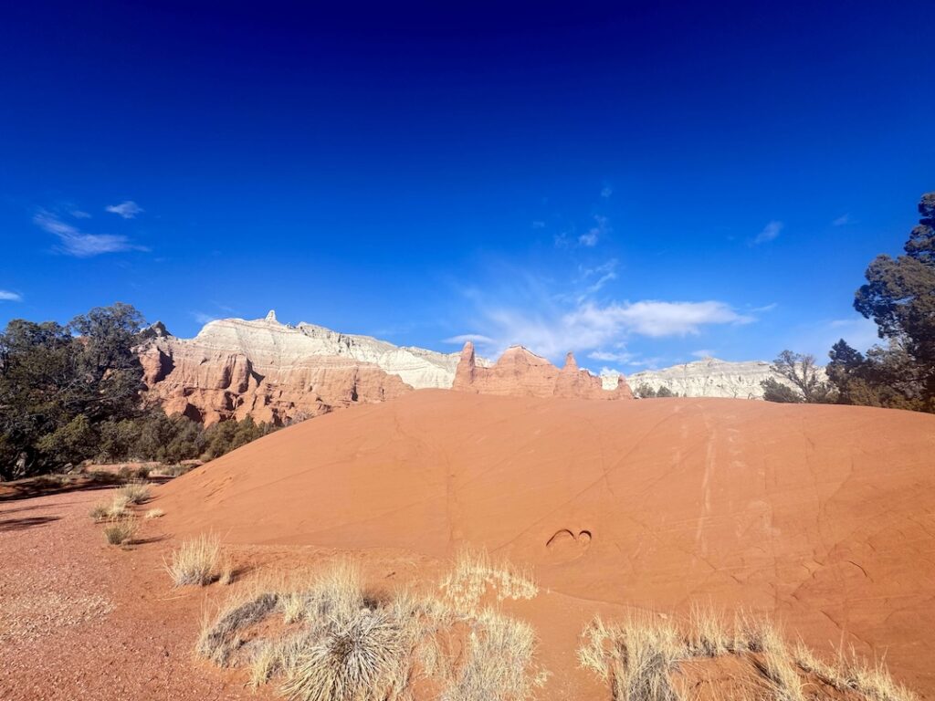
Cell Service and Navigation
Cell service inside Kodachrome Basin State Park is limited and unreliable. Most carriers drop to one bar or nothing once you’re away from the main road. Don’t plan on navigating with live data once you’re inside. Download offline maps before you leave. Google Maps and Maps.me both work well for the approach on Cottonwood Canyon Road. The trail itself is short and well-signed, so you’re not going to get lost, but having offline coverage for the surrounding area is smart. GPS works reliably throughout the park. Your coordinates are solid even when cell data is gone.
What to Expect on Kodachrome Nature Trail
The Trail
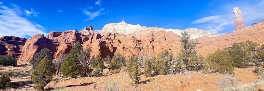
Kodachrome Nature Trail is a short loop. It’s flat, well-maintained, and easy to follow. No scrambling, no exposure, no technical terrain. The path winds through the park’s signature geological formations and returns you to the trailhead without drama. The surface is packed dirt and sand. It’s dry, stable, and accessible for most hikers. Families with younger kids handle it fine. The trail is one of the park’s best introductions to what makes Kodachrome Basin special.
The Spires
Here’s the thing about Kodachrome Basin’s spires: they’re called sedimentary pipes, and there’s nowhere else in the world quite like this concentration of them. These columns of harder rock were exposed as the surrounding sandstone eroded away. They now jut out of the desert floor like natural monuments, some short and squat, some towering.
The Color
The color gradient in the rock shifts constantly as you move around the trail. Red, orange, white, pink, tan, all layered and banded across the formations. In the right light, especially early morning or evening, the whole basin glows. Desert plants fill in the gaps between spires: juniper, yucca, rabbitbrush, scattered wildflowers if you’re there in spring. It’s a complete desert ecosystem packed into a small, walkable loop.
The Light
Golden hour here is something else. The spires catch the low-angle light and go deep red-orange. Early morning is ideal for photography because you get warm light on the formations before the sky blows out. The blue desert sky at midday is still striking but harsh for photos. Sunset can be incredible from the right spot near the trail. If you’re staying in the park campground, wander over in the last hour of light. It’s worth it every time.
Trail Difficulty and Length
This is as easy as it gets. The Kodachrome Nature Trail is 0.4 miles with 26 feet of elevation gain. It’s a loop. It’s flat. It’s short. Even if you rarely hike, you’ll handle this one. The only thing that might slow you down is stopping to take photos, which you absolutely will. Budget at least 20 to 30 minutes to walk it properly and actually absorb what you’re looking at.
Dog Friendly?
Yes. Dogs are welcome on the Kodachrome Nature Trail as long as they’re on a leash six feet or shorter. Utah State Parks standard rules apply. Bring water for your dog. The desert dries out both of you faster than you expect. In summer, stick to early morning or evening to protect paw pads from the hot ground. The trail has no shade worth mentioning, so heat management matters. Pick up after your dog. It’s a small community, the park is well-maintained, and other visitors shouldn’t have to deal with it.
What to Bring
The trail is short, but you’re still in the desert. Pack accordingly. Water is non-negotiable. Even on a 0.4-mile loop, carry more than you think you need, especially in summer. A quality daypack makes carrying everything easy. Sun protection is critical in the desert. Sunscreen, sunglasses, and a hat are non-negotiable. Lip balm too. The UV exposure at this elevation adds up fast. For photography, bring your widest lens. The spire formations and big sky reward wide-angle compositions. A polarizing filter cuts the desert glare and saturates the blue sky. Comfortable trail shoes are all you need. No boots required for this terrain.
Best Time to Hike Kodachrome Nature Trail
Spring and fall are the sweet spots. March through May and September through November bring mild temperatures, manageable crowds, and the best light conditions. Spring may include wildflowers in the surrounding basin, which adds color to an already vivid landscape. Summer is doable but hot. Go early, before 9 a.m., and be back in shade by midday. The heat gets serious by July and August. Winter is quiet and cold. The park stays open year-round, and snow-dusted spires against a clear blue sky are genuinely striking. Crowds drop to almost nothing. If you can handle the cold, it’s a legitimate option. For photography, golden hour is the answer any time of year. The 30 to 45 minutes after sunrise and before sunset are when Kodachrome Basin shows you what it’s really made of. 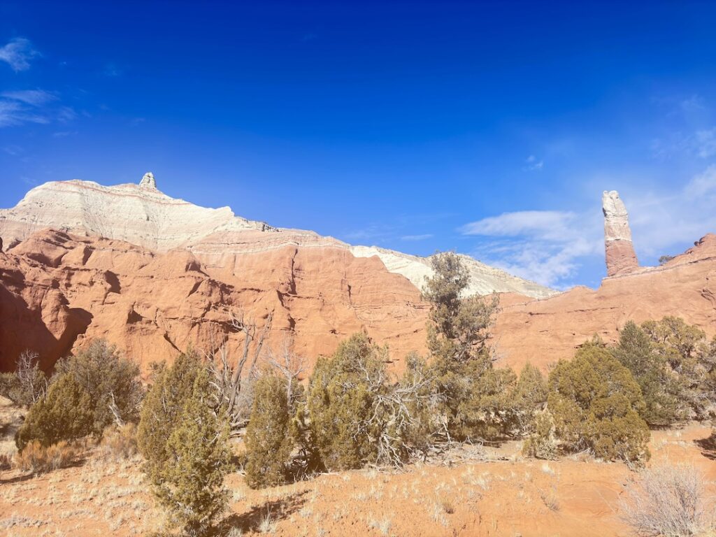
Rules and Regulations
Kodachrome Basin is a Utah State Park with standard state park rules in effect. Stay on designated trails. The formations look climbable, and some of them are, but the rules prohibit it. Rock scrambling on the spires is not allowed. The surfaces are also more fragile than they look. Pack out all trash. Leave No Trace principles apply throughout the park. No fires outside designated areas. Dogs must be on leash at all times. Drone use is prohibited. The $10 day-use fee covers a single vehicle. If you have a Utah State Parks Annual Pass, it’s accepted here.
Where to Stay Near Kodachrome Basin State Park
Cannonville, the nearest town, is tiny. For hotel accommodations, you’ll want to head toward Bryce Canyon City or Panguitch, both about 25 to 30 miles north on Highway 12 and US-89. Bryce Canyon City has several lodges and chain hotels right at the entrance to Bryce Canyon National Park. It’s a natural hub if you’re combining Kodachrome Basin with a Bryce Canyon visit.
Camping Nearby
Kodachrome Basin State Park has its own campground right inside the park. It’s one of the better state park campgrounds in Utah. Sites have hookups available, the facilities are maintained, and you wake up surrounded by those spires. It fills fast on weekends in spring and fall. Book early through the Utah State Parks reservation system. Cottonwood Canyon Road, which runs north toward Cannonville and south toward US-89, passes through BLM land with dispersed camping options. No hookups, no facilities, but free and scenic. The road surface varies, so check conditions before heading down it in a low-clearance vehicle. Estes handles it fine. Further south along US-89, there are additional developed campgrounds near Bryce Canyon and the Grand Staircase-Escalante area. Options range from full-hookup RV sites to primitive BLM land.
Nearby Adventures
Kodachrome Basin is surrounded by some of the best terrain in southern Utah. Start with the other trails inside the park itself. Angel’s Palace Trail covers 1.5 miles with 223 feet of gain and puts you up on a ridge with sweeping views of the whole basin. Check my Angel’s Palace Trail guide for the full breakdown. Panorama Trail is the park’s long loop, 5.8 miles with 574 feet of gain. It’s a solid half-day hike that takes you deep into the formations and gives you a completely different perspective on the basin. Read my Panorama Trail guide for details. Grand Parade Trail is another option inside the park, 2.1 miles with 236 feet of gain. It’s a good middle ground between the Nature Trail’s short loop and Panorama’s full commitment. From Kodachrome Basin, Escalante is about 25 miles east on Cottonwood Canyon Road. The Escalante Natural Bridge is one of the best short hikes in the area, an easy walk to a stunning natural arch. Don’t skip it if you’re in the region. Heading south on US-89 opens up the whole Grand Staircase-Escalante corridor. The Moki Dugway is a few hours south, a switchbacking unpaved road carved into the cliffs of Cedar Mesa with views that genuinely stop traffic. Bryce Canyon National Park is about 30 minutes northwest. It’s a completely different landscape, hoodoos instead of sedimentary pipes, but equally wild. Worth a full day on its own.
Plan This Hike
AllTrails has Kodachrome Nature Trail mapped with current trail conditions, user reviews, and offline map downloads. It’s the most useful planning tool I know for desert hiking. Grab the map, download it for offline use (you’ll need it, cell service is spotty), and read a few recent reviews to check for any seasonal closures or condition changes before you go. View on AllTrails
Chase the Quiet
I’ve hiked trails that take all day to pay you back. Kodachrome Nature Trail pays you back in about fifteen minutes. The spires just appear around you, completely alien and completely stunning, and the desert goes quiet except for the wind and whatever birds are moving through. A short trail doesn’t mean a small experience.
Support the Adventure
To make your walls less boring, check out my photography portfolio and bring a piece of the wild and my story into your home. If you’d like to fuel future adventures, you can donate a coffee on Ko-Fi. Every cup keeps me chasing sunrises and stories. When you shop using my affiliate links, every click helps support this blog at no extra cost to you. It’s a small way to keep Unicorn Adventure alive and kicking while I keep exploring. Subscribe to my mailing list for future updates, new stories, and behind-the-scenes adventures. Stay connected with me on Instagram and Facebook for more photos and daily inspiration. Thanks for being part of the journey, Unicorn Squadron!

Theo Maynard is a landscape photographer and adventure blogger based in Salt Lake City. He chases remote desert and mountain light across the American West, documents it all solo, and shares the journey through Unicorn Adventure. He’s on the autism spectrum, and that’s not a footnote, it’s the whole story. He creates to inspire others to get outside, chase what lights them up, and live their best possible life. Unapologetically himself.