The Panorama Trail Long Loop earns its name. The views come at you constantly, from every angle, across 5.8 miles of some of the strangest and most beautiful terrain in southern Utah. Sandstone spires rise out of the desert floor like they were planted there. Slot canyons cut through the rock in complete silence. The color in the cliffs shifts with the light all day long. Kodachrome Basin is one of those places that rewards curiosity. Every bend in the trail reveals something worth stopping for. I do my best hiking solo, on trails where I can set my own pace, stop when I want, and let the quiet do its work. The Panorama Loop delivers exactly that. Long stretches of peaceful desert, big views, and enough geological weirdness to keep your brain fully occupied. Here’s everything you need to plan your hike.
Quick Facts
| Trail Name | Panorama Trail Long Loop |
| Location | Kodachrome Basin State Park, Cannonville, Utah |
| Coordinates | 37.5226° N, 111.9920° W |
| Distance | 5.8 miles (loop) |
| Elevation Gain | 574 ft |
| Difficulty | Moderate |
| Time | 3–4 hours |
| Dogs Allowed | Yes, on leash |
| Fee | $10 day-use fee (Utah State Parks) |
| AllTrails | View on AllTrails |
How to Get There
From Cannonville, head south on Cottonwood Canyon Road for 9 miles. The drive is paved and easy, and the desert views start immediately. If you’re traveling Highway 12, one of the most scenic drives in the state, Kodachrome Basin is a natural stop. Turn south at Cannonville and you’ll hit the park entrance in about 9 miles. Pay your $10 day-use fee at the visitor center near the entrance. Utah State Parks Annual Pass holders get in free. From the entrance, the Panorama Trailhead is well-signed and a short drive inside the park. 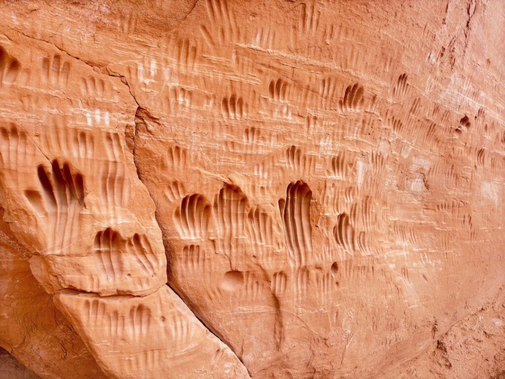
Parking Information
There’s a dedicated lot near the Panorama Trailhead with space for passenger vehicles, trucks, and rigs with trailers. Estes fit fine. The lot is paved and clearly marked. Spring and fall weekends fill up faster than you’d expect. Get there before 8 a.m. if you want a guaranteed spot and the best morning light on the formations. Weekdays are significantly less crowded at any time of year.
Cell Service and Navigation
Cell service inside the park is minimal. Most carriers drop to one bar or nothing once you’re away from the main road. On a 5.8-mile loop, you don’t want to be relying on live navigation anyway. Download the AllTrails map for offline use before you leave, or use a dedicated GPS app with the trail pre-loaded. The trail is well-marked on the ground with signs and cairns, but having the offline map as backup is smart on a loop this size. GPS satellite signal is reliable throughout the park even when cell data is gone. 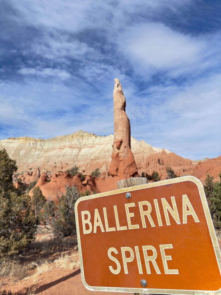
What to Expect on the Panorama Trail Long Loop
The Trail
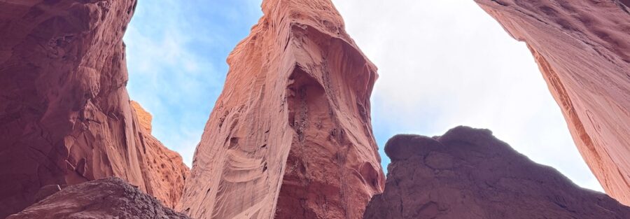
The Panorama Trail Long Loop is 5.8 miles of desert loop hiking with 574 feet of elevation gain. The terrain is mostly packed dirt and sand with moderate undulation. A few sections cross slickrock and require some basic route-finding, but nothing technical. The trail is well-signed throughout. Expect to cover varied ground: open desert flats, rock-walled canyon sections, exposed ridge stretches with panoramic views, and shaded slot passages. The loop changes character regularly, which keeps it interesting all the way around.
The Geology
Kodachrome Basin’s signature geology is sedimentary pipes, columns of harder rock exposed as the surrounding sandstone eroded away over millions of years. There are 67 of them identified in the park, and the Panorama Trail takes you past a good number of them. No two look alike. The Hat Shop is one of the trail’s named highlights. Hoodoos capped with harder stone sit clustered together on a stretch of the loop, looking exactly like what the name suggests. It’s a weird, wonderful section. Secret Passage is the other standout. A narrow slot canyon cuts through the rock, shaded and cool even on warm days. The contrast between the tight walls and the open desert you just walked through is immediate and striking. It’s a short section but one of the most memorable on the whole trail.
The Views
The color in the cliff bands shifts constantly as you move. Red, orange, white, and pink layer across the rock faces in formations that photograph differently at every hour of the day. The trail’s name isn’t ironic. The panoramic sections earn it. There are several points on the loop where the terrain opens up and puts the whole basin in front of you, low formations in the foreground, the mesa edges in the distance, and a massive sky overhead. These lookout sections are where the trail earns most of its elevation. The gains are gradual, not brutal, but the payoff views from the high points are significant. Stop, look around, and let it register before moving on. 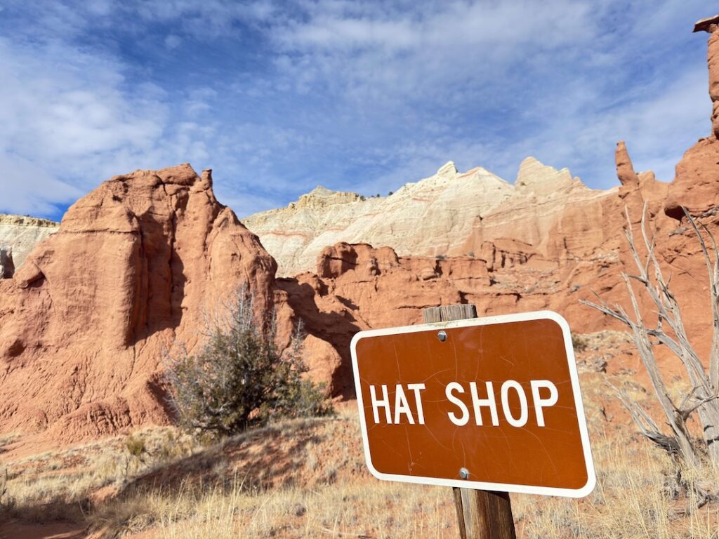
Trail Difficulty and Length
The Panorama Trail Long Loop is 5.8 miles with 574 feet of elevation gain. It’s rated moderate, and that’s accurate. The terrain isn’t technically demanding, but the distance and sun exposure require real preparation. Most fit hikers finish in 3 to 4 hours. Add time if you stop to photograph formations, explore the slot canyon, or sit at a viewpoint. Budget the full morning if you want to enjoy it without rushing. It’s not a trail for young children or inexperienced hikers in summer without careful planning. Spring and fall are the right seasons to introduce it to newer hikers.
Dog Friendly?
Yes. Dogs are welcome on the Panorama Trail with a leash of six feet or shorter. Utah State Parks standard rules. Water is critical for dogs on this trail. There’s no water along the route. Carry more than you think you need for both of you. In summer, the heat and ground temperature make midday hiking genuinely risky for dogs. Go early or skip summer entirely with your dog. Paw protection is worth considering for summer visits. The slickrock and packed sand hold heat. If the ground burns your hand at midday, it’s burning your dog’s paws.
What to Bring
For a 5.8-mile desert loop with real sun exposure, gear up properly. Carry 2 to 3 liters per person. There’s no water on the trail. A daypack with a hydration reservoir makes this easy. Sun protection is non-negotiable. Sunscreen with high SPF, a wide-brim hat, and UV-blocking sunglasses. Lip balm. The desert UV at elevation hits hard. Bring snacks for a 3 to 4 hour hike. Electrolytes if you’re hiking in warmer weather. A light windbreaker for early morning starts when the canyon sections are cool. For photography, a wide-angle lens handles the big views and panoramic lookouts. A polarizing filter cuts desert glare and punches up the blue sky. Bring extra batteries since cold mornings drain them fast. 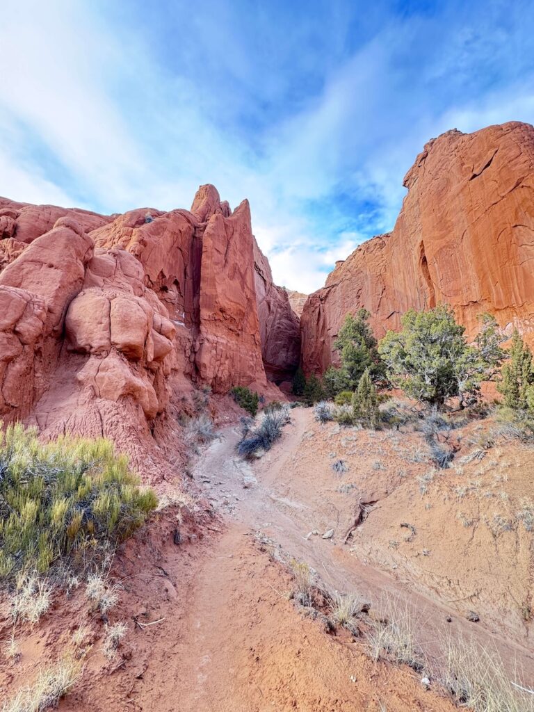
Best Time to Hike the Panorama Trail Long Loop
Spring (March through May) and fall (September through November) are the best seasons. Temperatures are manageable, the light is ideal, and the desert colors are at their most vivid. Wildflowers sometimes appear in spring across the open flats between formations. Summer hiking is doable but demands an early start. Be on trail by 7 a.m. and finished before noon. Afternoon temperatures in July and August are brutal, and there’s no shade on the exposed sections of the loop. Winter brings quiet and cold. The park stays open year-round, and snow on the red rock formations is striking from a photography standpoint. Crowds disappear almost entirely. Dress in layers and check road conditions on Cottonwood Canyon Road before heading out. For photography, golden hour rules. The 30 to 45 minutes after sunrise paints the spires deep red and orange. The low-angle morning light on the cliff bands along the loop is worth building your start time around.
Rules and Regulations
Kodachrome Basin is a Utah State Park. Standard state park rules apply throughout. Stay on marked trails. The formations are more fragile than they look, and off-trail foot traffic causes real damage over time. Climbing on the spires is prohibited. Pack out everything you pack in. Leave No Trace applies. No fires outside designated areas. Dogs on leash at all times. Drone use is not permitted anywhere in the park. Camping is restricted to designated campground sites. No dispersed camping inside park boundaries.
Where to Stay Near Kodachrome Basin State Park
Cannonville is a small town with limited lodging options. For hotel stays, head toward Bryce Canyon City or Panguitch, both 25 to 30 miles north on Highway 12 and US-89. Bryce Canyon City sits right at the entrance to Bryce Canyon National Park and makes a logical base if you’re combining the two parks. Several lodges and hotels cluster around the park entrance. 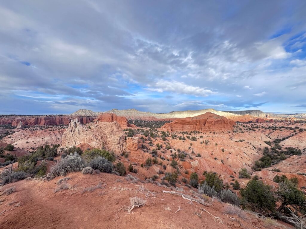
Camping Nearby
Kodachrome Basin State Park’s campground sits right inside the park, a short walk from the trailhead. Sites with hookups are available, facilities are maintained, and waking up surrounded by sandstone spires before anyone else is on trail is its own reward. Reserve through the Utah State Parks system, it books out weeks in advance during spring and fall. Cottonwood Canyon Road passes through BLM land both north and south of the park, offering dispersed camping options at no cost. No facilities, no hookups, but the scenery is equal to anything inside the park boundaries. Check road conditions first, especially after rain. The road goes unpaved south of the park and can be impassable when wet. Expanding your radius, the Grand Staircase-Escalante corridor has extensive BLM dispersed camping options. Escalante is about 25 miles east and serves as a hub for the whole region.
Nearby Adventures
Kodachrome Nature Trail is the park’s short introductory loop at 0.4 miles. Do it as a warm-up before the Panorama Trail or save it for the end when your legs need something easy. Angel’s Palace Trail covers 1.5 miles with 223 feet of gain and gets you up on a ridge with sweeping basin views. Read my Angel’s Palace Trail guide for details. Grand Parade Trail is a 2.1-mile loop through two box canyons inside the park. Quiet, shaded in sections, and a good option when you want a different perspective than the Panorama Trail’s big open views. Heading east on Cottonwood Canyon Road brings you to Escalante in about 25 miles. The Escalante Natural Bridge is a short, easy hike to a stunning natural arch and one of the best quick stops in the area. Drive south on US-89 toward the Utah-Arizona border and the terrain keeps getting more dramatic. The Moki Dugway is a white-knuckle unpaved switchback road cut into the cliffs of Cedar Mesa with views that have no business being that good. Bryce Canyon National Park is about 30 minutes northwest and worth a full separate day. The hoodoo formations there share some geological relatives with Kodachrome Basin but operate at a completely different scale.
Plan This Hike
AllTrails has the Panorama Trail Long Loop mapped with current conditions, user reviews, and offline map downloads. For a 5.8-mile loop in a park where cell service drops out, the offline map is not optional. Download it before you leave home, read the recent reviews for any seasonal closures or condition changes, and have it ready on your phone before you step out of the car. View on AllTrails
Chase the Quiet
There’s a stretch on the Panorama Loop, somewhere between Secret Passage and one of the high viewpoints, where the trail goes quiet enough that you can hear your own footsteps. The formations rise on both sides. The sky is enormous. Nothing is rushing you. That’s the stretch where this trail stops being a hike and starts being something else.
Support the Adventure
To make your walls less boring, check out my photography portfolio and bring a piece of the wild and my story into your home. If you’d like to fuel future adventures, you can donate a coffee on Ko-Fi. Every cup keeps me chasing sunrises and stories. When you shop using my affiliate links, every click helps support this blog at no extra cost to you. It’s a small way to keep Unicorn Adventure alive and kicking while I keep exploring. Subscribe to my mailing list for future updates, new stories, and behind-the-scenes adventures. Stay connected with me on Instagram and Facebook for more photos and daily inspiration. Thanks for being part of the journey, Unicorn Squadron!

Theo Maynard is a landscape photographer and adventure blogger based in Salt Lake City. He chases remote desert and mountain light across the American West, documents it all solo, and shares the journey through Unicorn Adventure. He’s on the autism spectrum, and that’s not a footnote, it’s the whole story. He creates to inspire others to get outside, chase what lights them up, and live their best possible life. Unapologetically himself.