Fortification Hill doesn’t care about your warm-up pace. It starts steep and stays steep. I first noticed this trail on a Lake Mead map and filed it away for later. Later arrived when I was already deep into a multi-day Las Vegas desert push, legs still carrying Turtlehead Peak from two days before, and I decided to finish the trip on this summit. That’s the kind of decision that sounds better in hindsight than in the moment. By the time I hit the trailhead I knew this one was going to cost something. The harder the physical challenge, the quieter everything else gets. Fortification Hill is the kind of hike that demands your full attention, no room for anything else. Loose volcanic rock, relentless grade, summit views that stretch farther than you expect. This is one of the most demanding accessible trails in the Lake Mead National Recreation Area, and it earns every superlative.
Quick Facts
| Location | Lake Mead National Recreation Area, Nevada |
| Coordinates | 36.03339, -114.66770 |
| Distance | 3.5 miles |
| Elevation Gain | 1,394 ft |
| Difficulty | Strenuous |
| Time | 3 to 5 hours |
| Dogs Allowed | Yes, on leash |
| Fee | $25/vehicle (America the Beautiful pass accepted) |
| Plan This Hike on AllTrails | |
How to Get There
Fortification Hill sits inside Lake Mead National Recreation Area, about 45 minutes southeast of the Las Vegas Strip and 25 minutes from Boulder City. Take US-93 South from Las Vegas toward Hoover Dam. Before you reach the dam, turn onto Kingman Wash Road on the Nevada side. It’s a signed turn but easy to miss at speed. Kingman Wash Road is unpaved and rough. High-clearance is strongly recommended. A standard sedan will struggle with the ruts and embedded rock, especially after rain. Follow the road about 4 miles to the informal trailhead parking area at the end. GPS coordinates for the trailhead: 36.03339, -114.66770. Download your nav before you leave pavement because signal drops as soon as you turn off US-93. 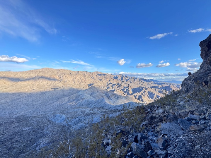
Parking Information
Parking is free and informal. There’s a wide spot at the road terminus where a handful of vehicles can pull off. No signage, no facilities, no restrooms. You’re self-sufficient from here. Park off to the side and leave space for other vehicles to turn around. The lot is first-come, first-served and rarely crowded given the access road difficulty. On weekday mornings you may well have it to yourself. Leave a note on your dashboard with your planned return time. Telling someone your itinerary before you drive in is smarter than relying on a cell signal that won’t be there.
Cell Service and Navigation
Cell service on Kingman Wash Road and at the trailhead is unreliable on all carriers. Once you’re on the trail, you’re on your own. Download AllTrails offline maps before you leave Boulder City or Las Vegas. A GPS device as a backup is worth carrying on a summit route like this where the descent line matters. The trail is not heavily signed at all junctions. Cairns mark the route in several sections on the upper mountain. If you lose the trail on descent, stop and retrace rather than bushwhacking. The volcanic terrain below the summit ridge is loose and the exposure is real. 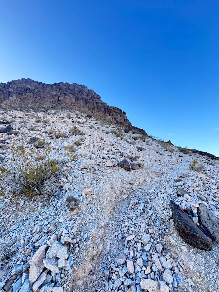
What to Expect on Fortification Hill
The Trail
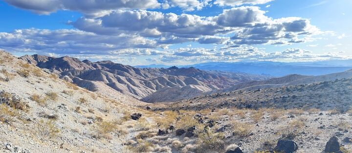
The route begins at the Kingman Wash parking area and follows a rocky wash northeast before angling up the broad south face of the mesa. The first half mile is deceptively moderate. Don’t let it set your expectations. The grade increases sharply once you leave the wash and gain the ridgeline. From here to the summit plateau, the trail is relentless, alternating between loose gravel switchbacks and sections of consolidated volcanic basalt that provide better footing but require more technical attention. Trekking poles help significantly on the ascent and are nearly essential on descent for protecting your knees. Near the summit, the trail narrows to a scramble section. Hands come out. The volcanic ledges are solid but the exposure increases. Take your time. There’s no technical rope work required, but this is not a family trail.
The Summit
The summit plateau is flat, wide, and worth every brutal step. At 1,394 feet of gain, the views are 360 degrees and unobstructed. Lake Mead fills the eastern frame, a sprawling blue reservoir cutting through red and black canyon walls. Hoover Dam sits to the southeast, visible in full from this elevation, the Colorado River threading away into Arizona. The Mojave Desert stretches north and west without interruption. For photography, the summit is strongest in the two hours after sunrise and the hour before sunset. The volcanic rock turns from black to deep red in low-angle light, and the contrast against the lake water is dramatic. Midday light bleaches everything flat. 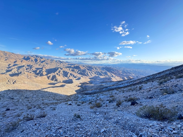
Trail Difficulty and Length
Fortification Hill is strenuous, no qualifications. The 3.5-mile round trip delivers 1,394 feet of elevation gain, much of it concentrated in the upper half of the climb. The trail is loose and rocky throughout. The scramble near the summit requires comfortable hands-on terrain and confident footwork. Hikers who’ve done Calico Tanks or Turtlehead Peak at Red Rock Canyon will find this in the same general difficulty class, with similar volcanic terrain and unshaded exposure. Allow three to five hours round trip. Faster hikers who are comfortable with the terrain can push it to two and a half on the ascent, but don’t rush the descent. Loose rock going down takes patience or you’ll turn an ankle. This is not a trail for first-time desert hikers or anyone in casual footwear. If you’re uncertain, start with the Railroad Tunnel Trail at Lake Mead first, get a feel for the heat and the exposure, then come back for Fortification Hill when your legs are ready.
Dog Friendly?
Leashed dogs are permitted on the trail. That said, be realistic about your dog’s fitness and experience. The scramble section near the summit requires dogs to be confident on uneven volcanic rock, and there are exposed drops along the summit ridge. In spring and fall, conditions are manageable for a fit trail dog. In summer, this hike is dangerous for dogs. The volcanic rock surface absorbs and radiates heat more intensely than sandstone. If it’s above 80 degrees by the time you reach the summit, your dog is already in the risk zone. Bring more water than you think you need for both of you. 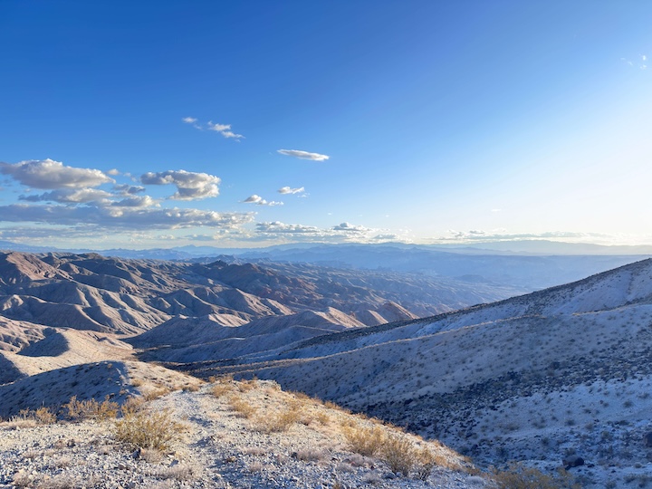
What to Bring
Water is the critical variable. Three liters per person minimum. Four if temperatures are above 75 degrees at the trailhead. There is no water source on the trail or at the parking area. The combination of exposed terrain, volcanic heat absorption, and strenuous grade depletes you faster than most trails of similar length. Trekking poles are worth the pack weight for this one. The descent on loose gravel is significantly safer with poles than without. Trail shoes with aggressive lug soles for the upper scramble. A hat with full brim coverage. Sunscreen. A headlamp if you’re targeting sunrise. Snacks that survive heat, no chocolate bars, bring real food. For emergency: a paper map or downloaded offline nav, a charged external battery for your phone, and a whistle. This is a remote trailhead. Self-rescue capability matters.
Best Time to Hike Fortification Hill
October through April is the window. The sweet spot is November through March when daytime highs stay in the 60s and the summit wind is cold but not dangerous. Spring offers wildflower color in the wash sections on the approach. Fall delivers the clearest air for lake photography. May and September are marginal. You can hike them with a 5 AM start, but there’s no margin for error on water or timing. June through August is genuinely dangerous. Temperatures in the canyon regularly exceed 110 degrees Fahrenheit and the volcanic rock surface adds radiant heat from below. The exposed summit offers no shade. Don’t go in summer. For photography: sunrise from the summit with the lake in the east frame and the dam visible to the south is the strongest composition this trail offers. You’ll need a headlamp start to hit the summit before first light. The effort is worth it. Afternoon light on the volcanic rock in fall, when the desert floor glows orange and the lake goes flat and silver, is the other window worth planning around.
Rules and Regulations
Lake Mead National Recreation Area charges $25 per vehicle. America the Beautiful annual passes are accepted and cover the fee. Stay on the established trail route. The desert soil crust on the approach through the wash is fragile and does not recover quickly from repeated off-trail foot traffic. Drones are not permitted in the recreation area. No fires at the trailhead or on the summit. Pack out everything. Flash flood risk in the Kingman Wash approach is real after heavy rain, check the National Weather Service forecast for Clark County before committing to a drive in. The wash can flood with no warning even in clear local weather if there’s been rain upstream.
Where to Stay Near Fortification Hill
Boulder City is the closest town and the most practical base for a Fortification Hill day hike. It’s 25 minutes from the trailhead and has a genuine small-town feel that’s a hard contrast to the Strip. For Las Vegas-based stays, Marriott Bonvoy properties like the Grand Chateau put you close to the US-93 corridor for an easy early morning drive southeast. IHG Rewards options in Henderson are closer to the Lake Mead access roads and avoid Strip traffic entirely. Hilton Honors members can look at properties near the Henderson convention area for a similar distance advantage. For anyone doing back-to-back Lake Mead days, Boulder City’s local hotels put you 15 minutes from multiple trailheads and within walking distance of the Hoover Dam Museum and the historic downtown.
Camping Nearby
Kingman Wash dispersed camping sits right on the shore of Lake Mead, accessed by the same Kingman Wash Road you drove in on. The camping spots are primitive, directly on the water, with canyon walls rising around the site. A 4×4 with good clearance makes the access easier but standard trucks can manage it in dry conditions. It’s one of the most isolated lakeside camping experiences accessible by vehicle in the region. I’ve camped it and it’s the kind of site that makes a Fortification Hill sunrise worth the full commitment. Stewart’s Point Campground is a designated Lake Mead NRA campground further east along Lakeshore Road with more accessibility, vault toilets, and direct water views. Good option if dispersed camping isn’t your preference. Reservations at recreation.gov. Lovell Canyon in the Spring Mountains is 45 minutes northwest of the park, free dispersed camping at 7,000 feet elevation in the pines. A strong contrast to the desert floor and a good choice if you’re combining Fortification Hill with Red Rock Canyon hiking over multiple days.
Nearby Adventures
The Railroad Tunnel Trail at Lake Mead (8.2 miles, 931 ft gain) follows the old Hoover Dam construction railroad bed through five volcanic tunnels with lake views the entire route. Start here before attempting Fortification Hill if you want to gauge your desert-hiking fitness. Both trails are covered in the Las Vegas hiking guide along with Calico Tanks, Kraft Mountain Loop, Ice Box Canyon, and the Valley of Fire trails. Hoover Dam is a 20-minute drive from the Fortification Hill trailhead and worth the stop. The inside tour covers the dam’s mechanical infrastructure and the construction history in detail. The Boulder City Hoover Dam Museum on Arizona Street provides historical context on the workers who built it. The Lake Mead Scenic Drive loops along the reservoir’s Nevada shore with consistent pull-outs for photography and a route that covers terrain you won’t see from the trails.
Plan This Hike
Fortification Hill is on AllTrails with current photos, trail condition reports, and an offline map you can download before you lose signal on Kingman Wash Road: View on Alltrails. Check the recent reviews before you go. Hikers post real-time condition updates on the scramble sections and current water requirements. AllTrails Pro adds offline topo maps that matter on a summit route where the cairn line can be ambiguous on descent.
Chase the Quiet
At the Fortification Hill summit, the desert goes totally silent except for wind. Lake Mead stretches east in both directions, massive and blue and still. Hoover Dam sits to the south, a structure I’ve driven over a dozen times and never quite understood until I saw it from this elevation. The whole engineered relationship between that dam and this water and this desert makes a different kind of sense from up here.
Support the Adventure
To make your walls less boring, check out my photography portfolio and bring a piece of the wild and my story into your home. If you’d like to fuel future adventures, you can donate a coffee on Ko-Fi. Every cup keeps me chasing sunrises and stories. When you shop using my affiliate links, every click helps support this blog at no extra cost to you. It’s a small way to keep Unicorn Adventure alive and kicking while I keep exploring. Subscribe to my mailing list for future updates, new stories, and behind-the-scenes adventures. Stay connected with me on Instagram and Facebook for more photos and daily inspiration. Thanks for being part of the journey, Unicorn Squadron!

Theo Maynard is a landscape photographer and adventure blogger based in Salt Lake City. He chases remote desert and mountain light across the American West, documents it all solo, and shares the journey through Unicorn Adventure. He’s on the autism spectrum, and that’s not a footnote, it’s the whole story. He creates to inspire others to get outside, chase what lights them up, and live their best possible life. Unapologetically himself.