Kraft Mountain Loop is in the Calico Basin area outside the official Red Rock Canyon Scenic Loop, which means no $15 park entry fee, no timed entry reservation, and free trailhead parking, a meaningful distinction from the other Red Rock Canyon trails. The 3.6-mile loop traverses sandstone canyons, boulder fields, and ridgeline terrain around Kraft Mountain, passing the Kraft Boulders, a recognized international bouldering destination.
Quick Facts
|
Trail Name |
Kraft Mountain Loop |
|
Location |
Calico Basin, near Red Rock Canyon NCA, Las Vegas, Nevada |
|
Coordinates |
36.1570° N, 115.4223° W (Kraft Mountain Trailhead, Calico Basin Road) |
|
Distance |
3.6 miles (loop) |
|
Elevation Gain |
620 feet |
|
Difficulty |
Moderate |
|
Time |
2-3.5 hours |
|
Dogs Allowed |
Yes, on leash |
|
Fee |
Free, no park entry fee or timed reservation required (Calico Basin area is outside the Scenic Loop) |
|
AllTrails |
How to Get There
From the Las Vegas Strip, take Summerlin Parkway west to Red Rock Canyon Road. Follow signs toward Calico Basin. The Kraft Mountain Trailhead is near the intersection of Calico Basin Road and Sandstone Drive in the Calico Basin residential area. The trailhead is outside the Red Rock Canyon Scenic Loop boundary, no entry fee, no reservation required.
From I-215, take the Summerlin Parkway west exit and follow to Red Rock Canyon Road / Calico Basin Road. The drive from the Strip takes about 25-30 minutes. Download AllTrails offline for the trailhead GPS before leaving cell coverage on the residential approach.
Parking Information
Free parking at the Kraft Mountain Trailhead near Calico Basin Road and Sandstone Drive. No fee, no permit. The lot fills on weekends during October through April peak season; arrive before 8 a.m. on busy days. If the trailhead lot is full, roadside parking along Calico Basin Road is available with a short walk to the trailhead. No facilities at the trailhead.
Cell Service and Navigation
Cell coverage is present on the approach through Calico Basin. It may decrease on the trail. Download AllTrails offline with the full loop GPS before arriving. The trail is not always clearly marked; route-finding through the canyon and boulder sections requires the GPS track, especially on the second half of the loop where the ridgeline descent can be ambiguous. A downloaded offline map is the most important preparation for this trail.
What to Expect on the Kraft Mountain Loop
The Sandy Wash Approach
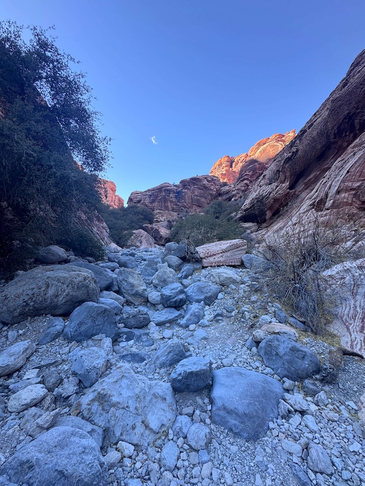
The trail begins in a sandy desert wash through the Calico Basin terrain. The approach section is flat and easy, giving the impression of an accessible moderate hike. The character shifts significantly as the trail enters the canyon and boulder terrain. The wash approach passes through the desert scrub environment of the basin floor before the mountain’s rocky terrain rises around the route.
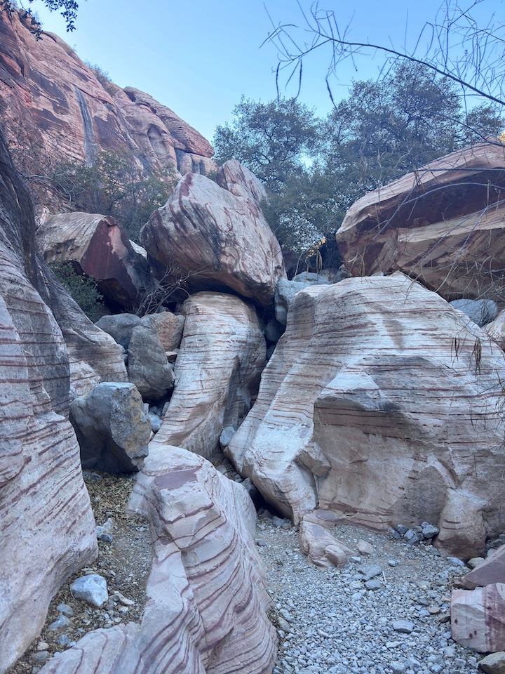
The Kraft Boulders
The Kraft Boulders are a recognized international bouldering destination, a collection of massive smooth sandstone boulders that attract climbers from around the world for the quality and variety of the bouldering problems on the rock faces. Even for non-climbers the boulders are visually impressive: the scale of the individual rock masses, the texture of the Aztec Sandstone surface, and the spectacle of watching climbers navigate them from trail level. The Kraft Boulders are a named stop on the loop rather than a background feature.
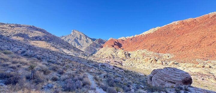
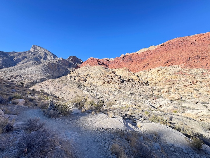
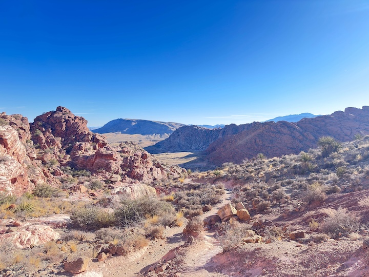
Canyon and Ridgeline
Beyond the boulders, the trail winds through narrow canyon sections with the characteristic Calico Basin red and white sandstone walls. The route climbs onto a ridgeline with panoramic views of Red Rock Canyon to the west and the Las Vegas Valley to the east. The ridgeline section is the most exposed and the most visually rewarding: the Spring Mountains above, the canyon formations below, and the basin spreading east toward the city.
The descent from the ridgeline is steep and rocky in sections, the part that earns the moderate rating. The route back to the trailhead completes the loop through additional canyon and wash terrain.
For photography: the Kraft Boulders in morning light from the east for the sandstone texture and the scale of the rock masses against the sky. The ridgeline for the panoramic canyon and valley view in late afternoon from the west. Wide-angle for the boulder field in landscape context and the ridgeline panorama, mid-range for the sandstone surface detail.
Trail Difficulty and Length
Moderate is the appropriate rating. The steep and rocky ridgeline descent section borders on difficult, but the overall loop stays in the moderate category. Route-finding adds complexity beyond the physical demands. Budget 2-3.5 hours with time at the boulders and the ridgeline.
Dog Friendly?
Yes. Dogs are permitted on leash. The rocky and sharp sandstone sections of the canyon and ridgeline are rough on paws; assess as you go and redirect dogs to smoother terrain when available. No water on trail; bring 1+ liter for dogs. The sand-to-rocky terrain progression means the approach is comfortable for dogs before the route becomes more demanding in the canyon sections.
What to Bring
Water: 2 liters for a 3.6-mile moderate desert loop. Sun protection for the exposed ridgeline section. Sturdy hiking shoes or trail runners with grip for the rocky canyon and ridgeline terrain. GPS or offline AllTrails map, essential for this trail given the route-finding demands in the canyon and on the descent. Camera with wide-angle for the boulder field and ridgeline panorama.
Best Time to Hike Kraft Mountain Loop
The free access and no-reservation system makes Kraft Mountain Loop a viable any-day option in peak season when the Red Rock Scenic Loop’s timed entry spots are full. Many Las Vegas-area hikers use Kraft Mountain as the overflow option for busy Scenic Loop days.
Rules and Regulations
Leave No Trace principles apply throughout. Stay on established trail where visible; route-find responsibly through the canyon sections without cutting new paths on fragile desert soil. No carving or marking rocks. Pack out all trash. Dogs on leash. No restrooms or trash cans at the trailhead. No park entry fee or reservation required for this area.
Where to Stay Near Las Vegas
Las Vegas, about 25-30 minutes east, has full city hotel infrastructure. For points travelers, check available Marriott Bonvoy properties in Las Vegas, IHG Rewards hotels in Las Vegas, and Hilton Honors options in Las Vegas. Summerlin-area properties are closest to the Calico Basin trailhead.
Nearby Adventures
Red Rock Canyon Scenic Loop trails (all requiring entry and timed reservation except this trail): Calico Tanks Trail (2.3 miles / 419 ft), Ice Box Canyon Trail (2.1 miles / 439 ft), Lost Creek Trail (0.6 miles / 108 ft), Turtlehead Peak Trail (4.6 miles / 1,978 ft), and Spooky Canyon (0.8 miles). Kraft Mountain Loop’s free access and no-reservation status makes it the natural default for days when Scenic Loop slots are unavailable or when visitors want to avoid the entry process.
Red Springs Boardwalk is another Calico Basin area easy accessible walk, family-friendly and on the same road as the Kraft Mountain Trailhead. Both can be done in the same Calico Basin visit.
Plan This Hike
AllTrails has Kraft Mountain Loop mapped with offline GPS capability and recent condition reports. The GPS track is particularly important for this trail’s route-finding sections. Download before leaving Las Vegas. Plan your hike on AllTrails and download offline before heading to Calico Basin.
Chase the Quiet
Kraft Mountain Loop gives you the Red Rock Canyon sandstone experience without the reservation system and the entry fee and the line at the gate. The Calico Basin trailhead is in a residential area. The trail goes immediately into canyon and boulder terrain that reads like the main Scenic Loop without the management structure around it. The Kraft Boulders are their own world, the kind of rock that draws climbers from other continents to a trail 25 minutes from the Strip. That specificity of place is worth knowing about regardless of whether climbing is your thing. Worth the drive.
Support the Adventure
To make your walls less boring, check out my photography portfolio and bring a piece of the wild and my story into your home.
If you’d like to fuel future adventures, you can donate a coffee on Ko-Fi. Every cup keeps me chasing sunrises and stories.
When you shop using my affiliate links, every click helps support this blog at no extra cost to you. It’s a small way to keep Unicorn Adventure alive and kicking while I keep exploring.
Subscribe to my mailing list for future updates, new stories, and behind-the-scenes adventures.
Stay connected with me on Instagram and Facebook for more photos and daily inspiration.
Thanks for being part of the journey, Unicorn Squadron!

Theo Maynard is a landscape photographer and adventure blogger based in Salt Lake City. He chases remote desert and mountain light across the American West, documents it all solo, and shares the journey through Unicorn Adventure. He’s on the autism spectrum, and that’s not a footnote, it’s the whole story. He creates to inspire others to get outside, chase what lights them up, and live their best possible life. Unapologetically himself.