Lost Creek Trail is a short, easy walk near the Willow Springs Picnic Area in Red Rock Canyon National Conservation Area, about 7 miles into the Scenic Loop Drive. The trail winds through a shaded canyon with petroglyphs on the canyon walls and ends at a seasonal waterfall, Lost Creek Falls, that flows after winter rainfall and spring snowmelt.
Quick Facts
|
Trail Name |
Lost Creek Trail |
|
Location |
Red Rock Canyon National Conservation Area, near Las Vegas, Nevada |
|
Coordinates |
36.1575° N, 115.4940° W (Willow Springs / Lost Creek Trailhead) |
|
Distance |
0.6 miles roundtrip |
|
Elevation Gain |
108 feet |
|
Difficulty |
Easy |
|
Time |
20-45 minutes |
|
Dogs Allowed |
Yes, on leash |
|
Fee |
$15 per vehicle; America the Beautiful Pass accepted. Timed entry reservation required, book at recreation.gov before your visit. |
|
AllTrails |
How to Get There
From the Las Vegas Strip, take State Route 159 (West Charleston Boulevard) west approximately 17 miles to the Red Rock Canyon National Conservation Area entrance. The Lost Creek Trailhead is near the Willow Springs Picnic Area, about 7 miles into the Scenic Loop Drive. The drive from Las Vegas takes about 30-40 minutes to the visitor center, then additional time on the one-way Scenic Loop.
Red Rock Canyon’s timed entry reservation system requires booking at recreation.gov before arriving. Walk-up entry is not guaranteed on busy days. The Scenic Loop Drive is one-way; plan your trailhead order before entering.
Parking Information
Designated parking lot at the Willow Springs / Lost Creek Trailhead area on the Scenic Loop. Restrooms available at Willow Springs Picnic Area; no water stations. The lot shares use with Willow Springs picnic visitors and can fill on weekends. Arrive before 8 a.m. on peak season days.
Cell Service and Navigation
Cell coverage is solid on the approach from Las Vegas and decreases on the Scenic Loop. Download AllTrails offline before arriving. The Lost Creek Trail is short and well-marked; navigation is straightforward.
What to Expect on the Lost Creek Trail
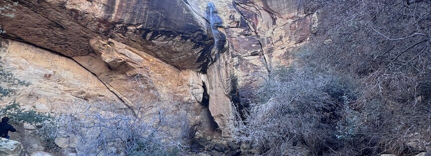
The trail begins on a maintained dirt path through desert scrub and Aztec Sandstone formations and enters a shaded canyon section where the temperature drops noticeably from the open desert approach. The canyon walls close in, providing the shade character that makes the Willow Springs area one of the cooler microclimates in Red Rock Canyon.
Petroglyphs are present on the canyon walls along the trail. These are Native American rock carvings, Ancestral Puebloan period and possibly earlier, marking the canyon with figures and symbols that have been here for centuries. Do not touch the petroglyphs; skin oils damage the rock art and the surrounding surface. Observe from the trail without climbing on the rocks where petroglyphs are located.
Lost Creek Falls is the trail’s terminus: a seasonal waterfall that forms after sufficient winter rainfall and spring snowmelt from the Spring Mountains above Red Rock Canyon. The waterfall is not present year-round and is not guaranteed on any specific visit. Check AllTrails condition reports within a week of your visit for current waterfall status. Even in dry conditions, the shaded canyon alcove at the trail’s end is a cool, quiet spot.
Desert bighorn sheep are occasionally visible on the cliffs above the Willow Springs / Lost Creek area. The canyon vegetation, plants sustained by the seasonal water and the shade, supports a more diverse wildlife community than the open exposed formations elsewhere in the park.
For photography: the petroglyphs in diffuse canyon light, not direct sun, are the most legible. Morning light reaches into the east-facing canyon before midday. The waterfall when present creates the pool reflection and flowing water compositions. Wide-angle for the canyon walls and trail context, mid-range for the petroglyph panels and the canyon alcove detail.
Trail Difficulty and Length
Easy is accurate: flat to gently rolling with minor rocky sections. Budget 20-45 minutes. The trail can be combined with the adjacent Willow Springs Loop for a longer outing.
Dog Friendly?
Yes. Dogs are welcome on leash. The shaded canyon provides more comfortable conditions for dogs than Red Rock’s exposed trails in summer. Still avoid midday summer visits with dogs, the approach to the canyon is fully exposed. No water source on trail; bring water for dogs.
What to Bring
Water even for a short canyon walk in the desert. Sun protection for the approach. Comfortable shoes. Camera with mid-range capability for the petroglyphs and waterfall detail.
Best Time to Visit
Summer is not recommended unless visiting before 8 a.m. The canyon shade helps but the approach and the Scenic Loop Drive context are hot in summer.
Rules and Regulations
Do not touch the petroglyphs. Do not climb on rocks where petroglyphs are located. Stay on designated trails. Timed entry reservation required at recreation.gov. $15 park entry or America the Beautiful Pass. Pack out all trash. Dogs on leash. No fires or camping.
Where to Stay Near Las Vegas
Las Vegas, 17 miles east, has comprehensive hotel infrastructure. For points travelers, check available Marriott Bonvoy properties in Las Vegas, IHG Rewards hotels in Las Vegas, and Hilton Honors options in Las Vegas.
Nearby Adventures
Red Rock Canyon trail catalog: Calico Tanks Trail (2.3 miles / 419 ft, slickrock scramble with Las Vegas skyline view), Ice Box Canyon Trail (2.1 miles / 439 ft, shaded gorge with boulder scramble and seasonal waterfall), Kraft Mountain Loop (3.6 miles / 620 ft, longer elevated loop), and Spooky Canyon (0.8 miles). Lost Creek Trail is the easiest and shortest of the Red Rock hiking entries; it pairs naturally with Ice Box Canyon on the same Scenic Loop visit for a combined easy-and-moderate day.
Valley of Fire State Park is about 1 hour northeast of Red Rock Canyon and delivers the full Valley of Fire desert experience for a separate day with the Fire Wave Loop and Elephant Rock Trail.
Plan This Hike
AllTrails has Lost Creek Trail mapped with offline capability and condition reports for waterfall status. Download before leaving Las Vegas. Plan your hike on AllTrails and check the condition reports for current waterfall flow and petroglyph accessibility.
Chase the Quiet
Red Rock Canyon’s most visited trails are the ones with the dramatic payoffs: the Las Vegas skyline from Calico Tanks, the boulder amphitheater of Ice Box Canyon. Lost Creek Trail is the quieter version: a short canyon walk with petroglyphs on the walls that have been there for centuries before Las Vegas existed 17 miles east, and a seasonal waterfall that the canyon has produced every wet winter since before anyone named the creek. The scale is small. The components are specific. That’s what makes it worth the 0.6-mile walk.
Support the Adventure
To make your walls less boring, check out my photography portfolio and bring a piece of the wild and my story into your home.
If you’d like to fuel future adventures, you can donate a coffee on Ko-Fi. Every cup keeps me chasing sunrises and stories.
When you shop using my affiliate links, every click helps support this blog at no extra cost to you. It’s a small way to keep Unicorn Adventure alive and kicking while I keep exploring.
Subscribe to my mailing list for future updates, new stories, and behind-the-scenes adventures.
Stay connected with me on Instagram and Facebook for more photos and daily inspiration.
Thanks for being part of the journey, Unicorn Squadron!

Theo Maynard is a landscape photographer and adventure blogger based in Salt Lake City. He chases remote desert and mountain light across the American West, documents it all solo, and shares the journey through Unicorn Adventure. He’s on the autism spectrum, and that’s not a footnote, it’s the whole story. He creates to inspire others to get outside, chase what lights them up, and live their best possible life. Unapologetically himself.