

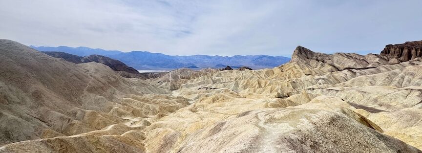
The Golden Canyon and Gower Gulch Loop is Death Valley’s most complete hike. Six and a half miles that hit everything the park does well: tight canyon walls glowing gold in the morning light, a towering red cliff face that looks borrowed from another planet, a stretch of wild open badlands, the most famous viewpoint in the park, and a long wash back out through terrain that feels genuinely remote. It’s a full morning, and it earns every hour.
Quick Facts
| Trail Name | Golden Canyon and Gower Gulch Loop via Zabriskie Point |
| Location | Death Valley National Park, California |
| Coordinates | 36.4207° N, 116.8466° W |
| Distance | 6.4 miles (loop) |
| Elevation Gain | 1,082 ft |
| Difficulty | Moderate |
| Time | 3–5 hours |
| Dogs Allowed | No (pets not permitted on park trails) |
| Fee | $35 per vehicle (7-day pass) or America the Beautiful Pass |
| AllTrails | View on Alltrails |
How to Get There
The loop has two trailheads: Golden Canyon and Zabriskie Point. Most hikers start at Golden Canyon, which puts you in the narrows immediately and saves Zabriskie’s views for the middle of the hike rather than the beginning.
Golden Canyon Trailhead: From Furnace Creek, drive south on Badwater Road for about 2 miles. The trailhead parking lot is on the left, clearly signed.
Zabriskie Point: From Furnace Creek, drive east on CA-190 for about 4.5 miles. The parking area is on the right at the signed overlook. If you prefer starting with the view and finishing in the canyon, this is your entry point.
Death Valley National Park charges $35 per vehicle for a 7-day pass. The America the Beautiful Annual Pass covers entry. Pay at the entrance stations or through recreation.gov in advance.
Parking Information
Golden Canyon Trailhead has a dedicated parking lot that fills quickly on weekends during peak season. Arrive before 7 a.m. to secure a spot. No restrooms at this trailhead.
Zabriskie Point has a larger parking lot with restroom facilities. It’s the better option if you’re arriving later in the morning or want a guaranteed spot. The lot fills on busy weekend mornings but not as quickly as Golden Canyon.
Both lots are paved and accessible to standard passenger vehicles, trucks, and SUVs.

Cell Service and Navigation
Cell service is unreliable throughout this section of Death Valley. Expect it to drop once you’re in the canyon and stay gone for most of the hike. Don’t plan on live navigation.
Download the AllTrails map for offline use before you leave. The loop is well-signed at most junctions, but the Gower Gulch section involves route-finding in an open wash where the trail can be less obvious. Having the offline map is not optional on a 6.4-mile loop in Death Valley.
Tell someone your itinerary before you go. Emergency response in Death Valley is slow by necessity. Self-sufficiency is the baseline requirement here.
What to Expect on the Golden Canyon and Gower Gulch Loop
The first 1.5 miles follow Golden Canyon through some of the most photogenic terrain in the park. The canyon walls rise steeply on both sides, banded in gold, amber, and rust, and the morning light bouncing between them creates a warm glow that lasts into mid-morning. The path is packed gravel and sand, easy underfoot, wide enough to walk without thinking about your footing.
Red Cathedral appears at roughly 1.3 miles. It’s a 900-foot cliff face of red conglomerate, massive and abrupt against the surrounding badlands. Most hikers stop here for photos before continuing. A short spur leads closer to the base. It’s worth the extra few minutes.
The canyon narrows and widens through this section, alternating between tight passages and open chambers. The walls show clear layering of different geological deposits. If you slow down and look at the rock closely, the banding tells a story that took millions of years to write.
Past Red Cathedral, the route climbs out of the canyon and into the open badlands. This is the hike’s main elevation gain, roughly 600 feet through eroded, wrinkled terrain with no shade and increasingly wide views. The trail is steeper here and the footing gets looser. This section requires more attention than the canyon floor.
The landscape changes dramatically. The tight walls are gone. The badlands open up in every direction, layered hills of yellow and gray mudstone eroded into ridges and gullies that stretch to the horizon. It’s exposed, it’s hot in the wrong season, and the views are enormous.
Zabriskie Point sits at the top of this climb, marked by a paved overlook and, depending on the time of day, a crowd of visitors who drove up from the parking lot. The view here is one of Death Valley’s most photographed: the eroded badlands dropping away into the valley, with the Panamint Range across the horizon. Take the break. Eat something. The second half of the loop starts from here.
From Zabriskie Point, the route drops into Gower Gulch, a wide, open wash that carries you back toward Golden Canyon over the final 3-plus miles. This section feels completely different from the first half. Wider, quieter, less dramatic in the canyon-wall sense, but with its own appeal. The terrain is more open, the light comes from a higher angle, and you often have the wash entirely to yourself.
The Gower Gulch section requires some route-finding. The wash is broad in places and the trail isn’t always obvious. This is where the downloaded offline map earns its keep. The general direction is consistent, downhill toward the valley floor, but staying on the actual route matters.
Old mining remnants appear along sections of Gower Gulch. Death Valley’s borax and mineral mining history shows up throughout the park, and these fragments in the wash are a reminder of what brought people into this landscape before it was a national park. Don’t disturb or remove any of it.

Trail Difficulty and Length
The Golden Canyon and Gower Gulch Loop is 6.4 miles with 1,082 feet of elevation gain. It’s rated moderate, and that’s accurate for fit hikers in the right season. The badlands climb to Zabriskie Point is the hardest section, steep and exposed with loose footing. The canyon sections are straightforward. Gower Gulch demands navigation attention.
The real difficulty multiplier is heat. Death Valley amplifies effort in ways that catch people off guard even at moderate temperatures. Start early, before 7 a.m. ideally, carry more water than you think you need, and have a turnaround plan if conditions get bad.
Budget 3 to 5 hours for the full loop. Add time if you stop at Red Cathedral, linger at Zabriskie Point, or move slowly through the Gower Gulch section. Don’t rush this one.
Dog Friendly?
No. Dogs are not permitted on this trail or most trails in Death Valley National Park.
The heat, exposed terrain, and distance make this a genuinely dangerous environment for dogs throughout most of the year. Leave them somewhere safe and cool.
What to Bring
A 6.4-mile desert loop with 1,082 feet of gain and zero shade requires real preparation.
Water is the priority. Carry a minimum of 3 liters per person, more in warmer weather. There is no water on the trail. A daypack with a hydration reservoir is the easiest way to manage this.
Sun protection is non-negotiable. Sunscreen, wide-brim hat, UV-blocking sunglasses, and sun-protective clothing on the exposed badlands section.
Food and electrolytes for a 3 to 5 hour effort. The dry air and heat deplete you faster than the effort alone suggests. Salty snacks and electrolyte tabs or packets help.
Sturdy trail shoes or hiking boots with grip. The canyon floor is packed gravel, manageable in anything decent. The badlands climb has loose footing that rewards real rubber soles.
For photography: a wide-angle lens for the canyon walls and the Zabriskie Point panorama, a mid-range zoom for Red Cathedral and the badlands detail. Bring extra memory cards. You’ll shoot more than you expect on this loop.
Best Time to Hike Golden Canyon and Gower Gulch Loop
November through March is the correct window. This hike is not safe in Death Valley summer. Temperatures regularly exceed 120
°F on the valley floor and the exposed badlands section amplifies that. People die in Death Valley every year from underestimating the heat. Don’t try this hike outside the cool season.
Within the peak season, morning starts are essential. Begin hiking by 7 a.m. to get through the exposed sections before midday. The canyon light is best in the first two hours after sunrise anyway, so an early start serves both safety and photography.
For photography, the Golden Canyon section is best lit in the first 90 minutes after sunrise when the low eastern sun bounces between the canyon walls. Red Cathedral goes deep red and orange in morning light. Zabriskie Point is best at either sunrise or sunset, not midday.
Weekdays in November and December see significantly fewer hikers than weekends. If solitude matters, go midweek.

Rules and Regulations
Death Valley National Park rules apply throughout this route.
Stay on the established trail. The badlands terrain is fragile and compaction from off-trail foot traffic causes permanent damage. Stick to the path.
Do not collect rocks, minerals, or historical artifacts. It’s a federal offense. The mining remnants in Gower Gulch are protected as part of the park’s cultural history.
Leave No Trace. Pack out everything you pack in. No trash cans on the trail.
Where to Stay Near Golden Canyon
Furnace Creek is 2 miles north of the Golden Canyon Trailhead and the natural base for this hike. The Inn at Death Valley is the park’s historic flagship property. The Ranch at Death Valley is the more casual, family-oriented option a short walk away.
For loyalty program options in the surrounding region, Marriott Bonvoy and Hilton Honors cover properties in Las Vegas (about 2 hours east) and Ridgecrest (about 2 hours west), both common staging cities for Death Valley trips. IHG Rewards has options along both corridors.
Camping Nearby
Furnace Creek Campground is the closest developed option, about 2 miles north of the Golden Canyon Trailhead. Hookup and non-hookup sites available. The most popular campground in the park, it books out weeks in advance during November through March. Reserve through Recreation.gov.
Texas Spring Campground is a smaller, quieter alternative near Furnace Creek with no hookups. First-come, first-served and tent-friendly. A good backup if Furnace Creek is full.
Backcountry dispersed camping is available in designated areas of Death Valley at least 1 mile from paved roads, 100 yards from water and trails, with a free permit. Check current conditions and restrictions with the park before planning sites near the Badwater Road corridor.
Nearby Adventures
The Golden Canyon area puts you in the middle of Death Valley’s most concentrated stretch of highlights.
Zabriskie Point is the midpoint of this loop but also worth a standalone sunrise visit. The paved overlook is 4.5 miles east of Furnace Creek on CA-190 and one of the most photographed spots in the park. If you’re doing this hike, you’ve already been there. If not, add it.
Artist’s Palette is about 10 miles south on Badwater Road via Artist’s Drive, a one-way scenic loop through volcanic mineral-stained hills. Best in late afternoon. Read my Artist’s Palette guide for timing and photography details.
Badwater Basin is about 17 miles south on Badwater Road. The lowest point in North America at 282 feet below sea level. The salt flat walk is short and completely unlike anything else in the park.
Dante’s View is about 25 miles east of Furnace Creek, a 5,475-foot overlook of the entire Death Valley basin. The elevation puts Badwater Basin directly below you. See my Dante’s View guide for timing and access details.
Mosaic Canyon Trail is about 35 miles northwest near Stovepipe Wells, the park’s best slot canyon hike through polished marble narrows. See my Mosaic Canyon guide if you’re adding a second day.
Plan This Hike
AllTrails has the Golden Canyon and Gower Gulch Loop mapped with user-reported conditions, recent reviews, and an offline map download. On a 6.4-mile loop in Death Valley where cell service is gone and the Gower Gulch section requires route-finding, the offline map is not optional.
Read the recent user reviews before you go. Conditions in the wash and on the badlands section can change after rain events. Check the Death Valley National Park website for any trail closures before heading out. View on Alltrails.
Chase the Quiet
The moment I remember most from this loop is somewhere in the middle of Gower Gulch, alone in a wide desert wash with the badlands rising on both sides and nothing moving in any direction. The canyon was behind me, Zabriskie was behind me, and the exit was still a couple miles ahead. Just me and the wash and the silence that Death Valley does better than anywhere else I’ve been. That’s a long way from a screen.
Support the Adventure
To make your walls less boring, check out my photography portfolio and bring a piece of the wild and my story into your home.
If you’d like to fuel future adventures, you can donate a coffee on Ko-Fi. Every cup keeps me chasing sunrises and stories.
When you shop using my affiliate links, every click helps support this blog at no extra cost to you. It’s a small way to keep Unicorn Adventure alive and kicking while I keep exploring.
Subscribe to my mailing list for future updates, new stories, and behind-the-scenes adventures.
Stay connected with me on Instagram and Facebook for more photos and daily inspiration.
Thanks for being part of the journey, Unicorn Squadron!

Theo Maynard is a landscape photographer and adventure blogger based in Salt Lake City. He chases remote desert and mountain light across the American West, documents it all solo, and shares the journey through Unicorn Adventure. He’s on the autism spectrum, and that’s not a footnote, it’s the whole story. He creates to inspire others to get outside, chase what lights them up, and live their best possible life. Unapologetically himself.