


The Best GPS Watches and Trail Navigation Tools for Hikers
I hike solo. No partner to double-check the map. No second opinion at a trail junction. When I’m deep in Grand Staircase-Escalante or navigating unmarked routes in the Sawtooths, my GPS is the difference between finding my way back and a very bad situation. I’ve driven Estes to trailheads where cell service doesn’t exist for 50 miles in any direction. Reliable navigation isn’t optional for how I adventure.
I’m also autistic. I process spatial information differently. A clean, predictable interface matters more to me than flashy features. I need devices that show my position clearly, work consistently, and don’t require troubleshooting under stress. When I’m tired and the trail forks and the light is fading, the last thing I need is a confusing menu system.
These are the GPS watches and navigation tools I’d actually recommend. Tested in real backcountry conditions. Handheld units, smart watches, and simple trackers. No gimmicks.
The Best GPS Watches and Navigation Tools
1. Garmin eTrex 22x, Reliable Handheld GPS With 25-Hour Battery Life
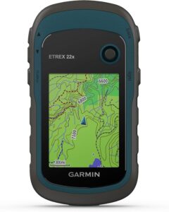
The Garmin eTrex 22x is a handheld GPS navigator with color screen, preloaded maps, and expandable storage via SD card. Runs on two AA batteries for 25+ hours.
This is the handheld I reach for on serious backcountry trips. The GPS locked onto satellites quickly and stayed accurate all day in thick forest cover where my phone had zero signal. Two AA batteries kept it running for over 20 hours. No charging anxiety in the wilderness. Just swap batteries and keep moving. The color screen handled all lighting conditions, including direct sun on exposed desert trails in Grand Staircase. Physical buttons work better with gloves than any touchscreen. Setup takes patience. You need to register online and buy an SD card for extra maps. Loading maps felt old-school at first. But once you get through initial setup, adding new trail maps gets much easier. The interface is button-driven and predictable. Same inputs, same results every time. That consistency matters when I’m navigating tired. For reliable backcountry navigation where cell service doesn’t exist, this is the tool I trust most.
2. Garmin eTrex 10, Budget Handheld GPS That Just Works
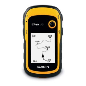
The Garmin eTrex 10 is a basic handheld GPS with monochrome screen. Connects to GPS and GLONASS satellites. Runs on two AA batteries for up to 20 hours. 5 ounces. Waterproof.
Stripped-down GPS tracking at a budget price. Picks up satellite signals quickly, even under thick tree cover. Connects to both GPS and GLONASS for better accuracy. I tracked routes and marked waypoints without trouble. Two AA batteries lasted three days of hiking without changing. At 5 ounces, it barely adds weight to your pack. Waterproof design handled rain and stream crossings. The tradeoff is the screen. Small monochrome display is tough to read on bright sunny days. Limited mapping compared to newer units. No color means navigation feels less intuitive. But the basic interface is dead simple. Easy to learn. Consistent. Predictable. For hikers who want reliable GPS position tracking and waypoint marking without complexity or high cost, this does exactly what it needs to do. Nothing more. Nothing less. I keep one as a backup in Estes.
3. Nihemin Military GPS Smart Watch, Offline Maps With Week-Long Battery
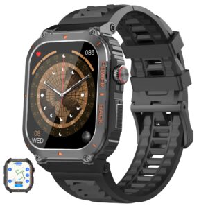
The Nihemin Military GPS Smart Watch is a GPS smart watch with offline maps, altimeter, barometer, and compass. Connects to multiple satellite systems. IP68 waterproof. Week-long battery life.
Offline maps on your wrist that actually work in dead zones. The GPS connects to multiple satellite systems and usually locks within 15 seconds. Turn-by-turn directions worked where my phone had nothing. I used this on backcountry trips through the Uintas and remote trails in Bears Ears where cell service is a fantasy. The altimeter and barometer matched my handheld devices closely. Compass helped when trails got confusing. The 2-inch screen shows map details clearly enough to follow routes. Battery lasted a full week of moderate GPS use on a single charge. IP68 rating held up during rain and stream crossings. The tradeoffs are build quality and interface polish. Screen scratches more easily than premium brands. Button responses sometimes lag when scrolling through menus. Heart rate readings get unreliable during hard activity. But for the price, getting offline maps, multi-satellite GPS, altimeter, barometer, and compass on your wrist with week-long battery is hard to beat.
4. PARDIC CyberX Military GPS Watch, Multi-Band GPS With 15-Day Battery
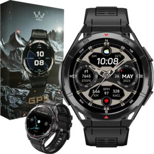
The PARDIC CyberX Military GPS Watch is a military-grade GPS watch with multi-band satellite connection, compass, altimeter, barometer, always-on display, and magnetic charging. Water resistant to 50 meters. 15-20 day battery.
The most durable GPS watch on this list. Multi-band GPS connects to four satellite systems for precise positioning. Route tracking stayed accurate on long mountain traverses through the Wasatch and exposed ridgelines where signal bounce can throw off cheaper units. Military-standard construction survived being banged against rocks and dunked in streams. Screen stays readable in bright sunlight with an always-on display. No button press needed to check position. Compass, altimeter, and barometer in one device saves space and weight. I used GPS tracking for 8 to 10 hours a day and still had power after a week. Magnetic charging tops off quickly at base camp. The tradeoffs are size and complexity. The 1.43-inch display feels bulky on smaller wrists. Over 150 sport modes create a complex interface that takes time to learn. Higher price than basic GPS watches. But for durability, satellite accuracy, and battery life on extended backcountry trips, this delivers.
5. Bushnell BackTrack Mini GPS, Simple 2-Ounce Return-to-Start Tracker
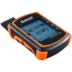
The Bushnell BackTrack Mini GPS is a basic GPS unit that shows direction and distance to saved waypoints. Big buttons. 35-hour battery. 2 ounces. Waterproof. Micro USB charging.
The simplest GPS on this list. Mark your starting point. Hike. It shows you direction and distance back. That’s it. Big buttons work with thick gloves. Two ounces. 35-hour battery. Waterproof. Setting waypoints takes just a couple of button presses. I charged it once during a week-long camping trip and still had power left. The simplicity is both the strength and the limitation. No detailed maps. No advanced route planning. No topo data. The 2.25-inch screen is hard to read in bright sunlight. Bluetooth connection to the phone app drops frequently. Sometimes it connected immediately. Sometimes I had to restart both devices. For serious backcountry navigation, this isn’t enough on its own. But as a lightweight backup that always gets you back to your starting point, it fills a specific role. I clip it to my pack as insurance on shorter hikes near Donut Falls or Rattlesnake Gulch where I don’t need full GPS capability.
6. Garmin eTrex 32x, Premium Handheld With Built-In Compass and Barometer
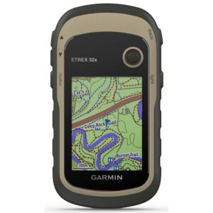
The Garmin eTrex 32x is a rugged handheld GPS with preloaded maps, electronic compass, barometric altimeter, and color screen. Runs on two AA batteries for up to 25 hours.
The upgraded eTrex with built-in compass and barometer. Everything the 22x does, plus navigation sensors that work when you’re standing still. The electronic compass shows your heading without moving, which matters at trail junctions when you need to orient before committing to a direction. Barometric altimeter tracked elevation accurately and warned about weather changes before storm clouds appeared. GPS signal stayed strong in thick forest cover when my phone dropped out. Color screen shows map details clearly in sunlight. Physical buttons work great with gloves. Same two AA batteries lasted three days of heavy use. Rugged build survived drops on rocky trails. Preloaded maps include roads and trails. The tradeoffs are screen size and learning curve. Small display requires frequent zooming to read map details. Menu system takes practice sessions at home before you feel confident on the trail. Bulkier than a watch-based GPS. But for the most capable handheld GPS navigation at this price, the 32x is the top of the eTrex line.
How to Choose Trail Navigation Gear
Start with how you hike. Solo backcountry trips in remote areas need serious GPS capability. Handheld units like the Garmin eTrex line offer the best maps, longest battery life, and most reliable satellite lock. GPS watches put navigation on your wrist with less capability but more convenience. Simple trackers work as lightweight backups.
Battery life matters most. You need devices that last for days without charging. Look for at least 20 hours in GPS mode. AA battery devices let you carry spares. Screen visibility in bright sunlight determines whether you can actually read your position. Water resistance is non-negotiable. Physical buttons beat touchscreens in cold weather with gloves. Multi-satellite connection improves accuracy in canyons and dense forest.
Frequently Asked Questions
What’s the single best GPS device on this list?
For serious backcountry navigation, the Garmin eTrex 32x. Best maps, compass, barometer, and 25-hour battery on AA batteries. For a GPS watch with offline maps, the Nihemin or PARDIC CyberX depending on your budget. For a dead-simple backup, the Bushnell BackTrack Mini.
Do I need a handheld GPS if I have a GPS watch?
Depends on where you hike. For well-marked trails with good signage, a GPS watch is enough. For remote backcountry with unmarked routes, canyons, or dense forest, a handheld GPS provides better maps, longer battery life, and more reliable satellite lock. I carry both on serious trips.
How important is multi-satellite connectivity?
Very important in challenging terrain. GPS alone can lose accuracy in deep canyons, dense forest, and narrow valleys. Devices that connect to GPS plus GLONASS, Galileo, or BeiDou maintain better accuracy in these conditions. For hiking in places like Grand Staircase slot canyons or thick Uintas forest, multi-satellite connection makes a real difference.
Are these devices good for someone with sensory sensitivities?
Yes. Physical buttons on the Garmin eTrex units provide consistent, predictable input. Same press, same result every time. No surprises. The Bushnell BackTrack Mini has big buttons with clear tactile feedback. Touchscreen-based devices can be less predictable. Choose devices with simple, consistent interfaces if sensory processing is a factor.
Should I still carry a physical map and compass?
Yes. Electronics fail. Batteries die. Screens crack. A physical map and baseplate compass weigh almost nothing and work without power. I carry both as backup on every backcountry trip. GPS is primary navigation. Map and compass are insurance. In remote areas, that insurance is not optional.
Navigation Is Not Optional
I hike solo in places where getting lost has real consequences. Remote desert. Unmarked backcountry. Slot canyons where cell service doesn’t exist. Every device on this list has been evaluated for satellite accuracy, battery life, screen readability, and reliability under real conditions.
The best GPS device is the one you carry, know how to use, and trust when the trail disappears. These do the job.
Support the Adventure
To make your walls less boring, check out my photography portfolio and bring a piece of the wild and my story into your home.
If you’d like to fuel future adventures, you can donate a coffee on Ko-Fi. Every cup keeps me chasing sunrises and stories.
When you shop using my affiliate links, every click helps support this blog at no extra cost to you. It’s a small way to keep Unicorn Adventure alive and kicking while I keep exploring.
Subscribe to my mailing list for future updates, new stories, and behind-the-scenes adventures.
Stay connected with me on Instagram and Facebook for more photos and daily inspiration.
Thanks for being part of the journey, Unicorn Squadron!
Theo Maynard is a landscape photographer and adventure blogger based in Salt Lake City. He chases remote desert and mountain light across the American West, documents it all solo, and shares the journey through Unicorn Adventure. He’s on the autism spectrum, and that’s not a footnote, it’s the whole story. He creates to inspire others to get outside, chase what lights them up, and live their best possible life. Unapologetically himself.