

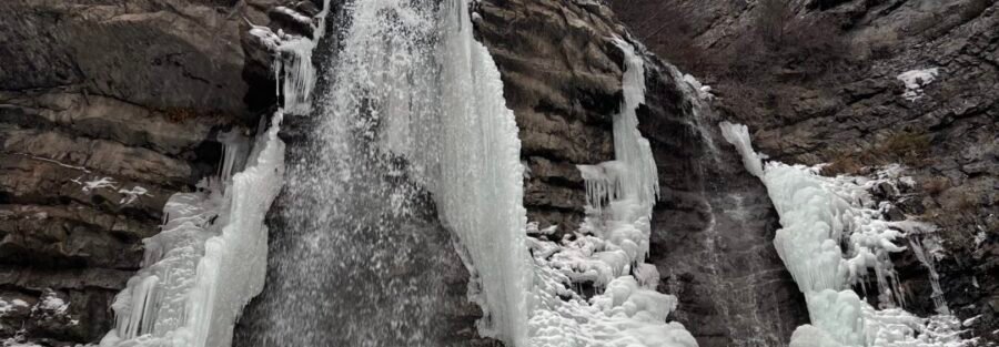
Battle Creek Falls is a 50-foot waterfall at the end of a 1.5-mile roundtrip in the Uinta-Wasatch-Cache National Forest above Pleasant Grove, Utah. The trailhead at Kiwanis Park sits at the end of Battle Creek Drive on the east edge of town, and the transition from residential street to canyon trail happens at the parking area. It’s one of the most accessible significant waterfalls on the Wasatch Front: no long drive, no highway canyon, just a residential street and a short hike. Battle Creek Falls sits in the Pleasant Grove trail catalog alongside the Primrose Overlook and Horse Spring Trail Loop and Big Baldy. Battle Creek Falls is the easy end of the Pleasant Grove trail difficulty spectrum. It’s the 30-minute family option in a cluster that includes moderate and serious routes from nearby trailheads.
Quick Facts
| Trail Name | Battle Creek Falls Trail |
| Location | Uinta-Wasatch-Cache National Forest, near Pleasant Grove, Utah |
| Coordinates | 40.3630 N, 111.7006 W (Kiwanis Park Trailhead) |
| Distance | 1.5 miles roundtrip |
| Elevation Gain | ~500 feet |
| Difficulty | Easy to Moderate |
| Time | 45-90 minutes |
| Dogs Allowed | Yes, on leash |
| Fee | Free |
| View on AllTrails | |
How to Get There
From I-15, take Exit 275 (Pleasant Grove/Lindon) and head east on Pleasant Grove Boulevard. Follow the road as it transitions to Battle Creek Drive through the residential area. Continue east on Battle Creek Drive until it ends at Kiwanis Park, where the trailhead is located. The drive from the freeway to the trailhead takes about 10-15 minutes through Pleasant Grove. From Salt Lake City, about 35-40 minutes south on I-15. From Provo, about 15-20 minutes north on I-15. The trailhead sits at the canyon edge on the eastern residential boundary of Pleasant Grove, which makes it an easy before-work or after-work option for Wasatch Front residents who want a quick nature hit without a drive.
Parking Information
The Kiwanis Park parking area at the trailhead has restrooms and serves as a legitimate starting point. It fills quickly on weekends and after school hours during the school year, as the trail is popular with local families and trail runners. Arrive early on weekend mornings. Overflow parking is available along Battle Creek Drive and the adjacent residential streets; park only in designated areas and respect residential access. 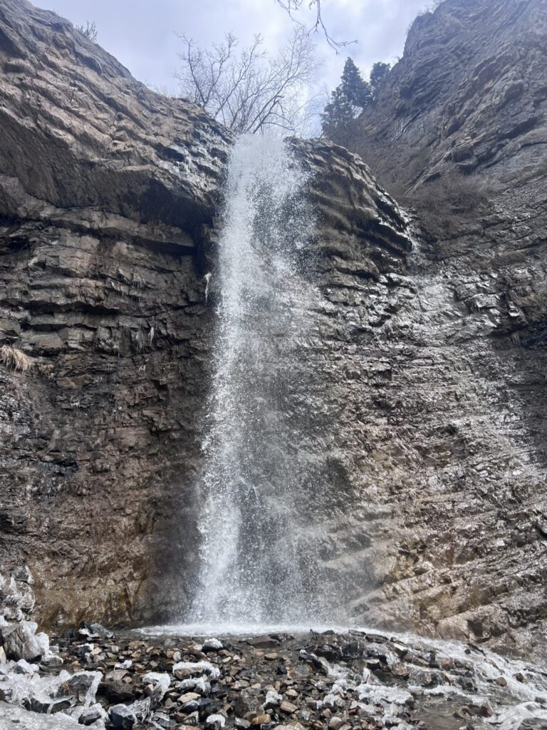
Cell Service and Navigation
Cell coverage is solid at the trailhead and along most of the trail given the proximity to the Pleasant Grove residential area. Download AllTrails offline as standard practice. The trail is well-marked and straightforward; navigation isn’t a challenge on this route. The falls are the destination and the trail goes directly to them.
What to Expect on the Battle Creek Falls Trail
The Trail
The trail from Kiwanis Park follows Battle Creek upstream through a canyon that opens progressively as you gain elevation. The lower section is shaded by canyon walls and riparian vegetation alongside the creek. The sound of the water accompanies the hike from the trailhead to the base of the falls. The trail gains 500 feet over 0.75 miles to the falls, which concentrates most of the elevation in a short distance. There are rocky sections and a few steep short pitches that earn the easy-to-moderate label; it’s not a flat nature walk, but it’s accessible to most hikers including older children and those with basic fitness levels. The path is well-maintained and clearly established throughout.
Battle Creek Falls
Battle Creek Falls drops approximately 50 feet over a rocky cliff into a shallow pool at the base. The pool area and the surrounding rock are cool and shaded even on warm days, making the falls a legitimate respite point in summer. The spray at the base is noticeable in high-flow conditions in spring and early summer. For photography: the canyon orientation creates a shaded environment that works well on overcast days without the contrast issues of direct sun on white water. Morning visits before the sun angles fully into the canyon produce the most even light for the falls. Wide-angle for the full falls and canyon walls, mid-range for the water and rock texture. A tripod or gorilla pod for any slow-shutter work to blur the cascade.
Trail Difficulty and Length
Easy to moderate is accurate: the gain is real for the short distance and the rocky sections near the top require attention, but the distance makes it accessible to essentially all fitness levels. Budget 45-90 minutes including time at the falls.
Dog Friendly?
Yes. Dogs welcome on leash. The creek alongside the lower trail gives dogs water access. The rocky upper sections near the falls require dogs to be comfortable on uneven terrain. Keep dogs leashed and out of the shallow pool area at the base of the falls where the rock is slippery. 
What to Bring
Water even for a short hike. The canyon is warmer than the shaded lower section makes it seem early on. Sun protection for any exposed sections. Footwear with grip for the rocky upper trail near the falls. No special gear required beyond what you’d bring on any short Wasatch Front hike. For photography: the same kit works here as any Wasatch Front waterfall: wide-angle, mid-range, tripod for slow shutter. Light is the variable; check what the canyon orientation produces at your planned visit time before committing to a specific timing.
Best Time to Visit
April through October. Spring (April through June) delivers the highest water volume from snowmelt and the trail’s wildflower color. The falls in late May at full flow with green canyon walls is the visual peak of the year. Summer visits work well with an early start before the canyon heats up. July and August afternoons in the lower canyon can be warm. The trail is short enough that even a summer midday visit is manageable if you carry enough water. Fall brings aspen color to the canyon and cooler temperatures through September and October. Winter is possible with microspikes or traction devices; the rocky upper section near the falls becomes icy after cold snaps.
Rules and Regulations
Stay on designated trail. No fires. Pack out all trash. Dogs on leash. The falls area can be slippery after rain; use caution on the wet rock. Leave No Trace principles throughout. 
Where to Stay Near Pleasant Grove
Pleasant Grove, Orem, and Provo on I-15 have full lodging infrastructure 15-20 minutes from the trailhead. For points travelers, check available Marriott Bonvoy properties in Orem, IHG Rewards hotels in Orem, and Hilton Honors options in Orem.
Camping Nearby
American Fork Canyon, accessible from UT-92 a short drive east, has developed campgrounds through recreation.gov. Dispersed camping on National Forest land is available with standard rules above the Pleasant Grove canyon trails.
Nearby Adventures
The Primrose Overlook and Horse Spring Trail Loop shares the Battle Creek Trailhead cluster and is the moderate step-up: 3.5 miles with 950 feet of gain to the Primrose Overlook with full Utah Valley views. Battle Creek Falls as a warm-up and Primrose Overlook as the main event makes a complete Pleasant Grove hiking day. Big Baldy from Pleasant Grove at 5.7 miles / 3,316 feet of gain is the serious summit option in the same area for anyone building toward harder Wasatch Front routes from this corridor. Bridal Veil Falls in Provo Canyon is the companion waterfall experience accessible from the Utah Valley, 10-15 minutes south on I-15 and east on US-189 at a larger scale (607 feet) but similar family-friendly accessibility.
Plan This Hike
AllTrails has Battle Creek Falls Trail mapped with offline capability and condition reports. Plan your hike on AllTrails and download the offline map before heading up Battle Creek Drive.
Chase the Quiet
The trailhead is at the end of a residential street and the falls are 0.75 miles up the canyon. That’s the whole distance between suburban Pleasant Grove and a 50-foot waterfall in a shaded canyon. The Wasatch Front consistently delivers this particular version of geographic efficiency. You don’t have to go far to get somewhere that sounds and feels like somewhere else entirely. Battle Creek Falls is 45 minutes door to door from most of the Salt Lake Valley. That math is worth using regularly.
Support the Adventure
To make your walls less boring, check out my photography portfolio and bring a piece of the wild and my story into your home. If you’d like to fuel future adventures, you can donate a coffee on Ko-Fi. Every cup keeps me chasing sunrises and stories. When you shop using my affiliate links, every click helps support this blog at no extra cost to you. It’s a small way to keep Unicorn Adventure alive and kicking while I keep exploring. Subscribe to my mailing list for future updates, new stories, and behind-the-scenes adventures. Stay connected with me on Instagram and Facebook for more photos and daily inspiration. Thanks for being part of the journey, Unicorn Squadron!

Theo Maynard is a landscape photographer and adventure blogger based in Salt Lake City. He chases remote desert and mountain light across the American West, documents it all solo, and shares the journey through Unicorn Adventure. He’s on the autism spectrum, and that’s not a footnote, it’s the whole story. He creates to inspire others to get outside, chase what lights them up, and live their best possible life. Unapologetically himself.