

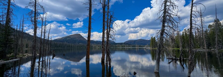
Haystack Lake isn’t the most dramatic hike on the Mirror Lake Highway. It doesn’t summit a 12,000-foot peak or require route-finding through a lake-dense alpine basin. What it does is take you 5.3 miles through pine and fir forest, across small streams, and to an alpine lake beneath Haystack Mountain with 377 feet of elevation gain and the particular quiet that comes from being a half-day walk from the highway. It’s the moderate option in the Crystal Lake Trailhead cluster that delivers a genuine lake experience without the full-day commitment of the harder Uintas routes. I’ve come to appreciate this kind of trail, the one that doesn’t ask you to prove anything to complete it. Certain trails create space for noticing things, the smell of the forest, the sound of the streams, the way the light on alpine water works at different hours. Haystack Lake gives you that space because the terrain isn’t demanding all your attention. You can just walk and notice. This guide covers Haystack Lake Trail from the Crystal Lake Trailhead.
Quick Facts
| Trail Name | Haystack Lake Trail |
| Location | High Uintas Wilderness, near Kamas, Utah |
| Coordinates | 40.6819° N, 110.9633° W (Crystal Lake Trailhead) |
| Distance | 5.3 miles roundtrip |
| Elevation Gain | 377 feet |
| Difficulty | Moderate |
| Time | 2.5-4 hours |
| Dogs Allowed | Yes, on leash |
| Fee | Mirror Lake Highway pass: $10 (1-3 day) or $20 (7-day); America the Beautiful Pass accepted |
| AllTrails | View on AllTrails |
How to Get There
From Kamas, take Mirror Lake Highway (UT-150) east approximately 32 miles to the Crystal Lake Trailhead, which is on the right side of the highway. The trailhead is clearly signed and serves multiple trails including the Haystack Lake Trail and the 20 Lakes Trail Loop. From Salt Lake City, plan about 1.5-1.75 hours: I-80 east to US-40 east toward Heber City, then UT-248 east to Kamas, then Mirror Lake Highway east. From Park City, Kamas is about 20 minutes south on UT-32. Mirror Lake Highway closes November 1st and reopens around Memorial Day weekend depending on snowpack. The Crystal Lake Trailhead is inaccessible during the winter months. The Haystack Lake Trail clears of snow earlier than the higher-elevation Uintas routes given its modest elevation gain, making it accessible somewhat earlier in the season than summit trails from the same corridor.
Parking Information
The Crystal Lake Trailhead has a large, well-maintained parking lot with restrooms and information kiosks. It serves multiple trailheads including the Haystack Lake Trail and the 20 Lakes Trail Loop, so it can fill on summer weekends. Arrive before 8 a.m. on peak days to secure a spot. Mirror Lake Highway pass required: $10 for 1-3 days, $20 for 7 days. America the Beautiful Annual Pass accepted. Pay at self-serve kiosks on the highway before the Crystal Lake Trailhead. 
Cell Service and Navigation
Cell coverage is absent at the Crystal Lake Trailhead and on the Haystack Lake Trail. Download AllTrails offline before leaving Kamas. The trail is well-maintained and marked, with straightforward navigation on the route to the lake. Having GPS active is useful for confirming your position near the lake, particularly if you’re exploring the shoreline.
What to Expect on the Haystack Lake Trail
The Trail
The trail from the Crystal Lake Trailhead winds through dense pine and fir forest on a maintained path with gentle grade changes. Stream crossings add variety to the lower sections; most are easy step-overs or short hops. The forest environment is shaded through much of the morning and provides a cooler hiking experience than exposed Uintas summit routes. The terrain opens as you approach Haystack Lake and the surrounding peaks become visible ahead. Haystack Mountain rises above the lake and gives the whole basin a distinctive visual anchor. The lake sits at the back of a gentle basin, and the approach delivers you to the shoreline without dramatic final push.
Haystack Lake
The lake is the kind of quiet alpine destination that rewards unhurried time. The water is clear, the shoreline has accessible rock sections for sitting, and the surrounding basin has the particular stillness of a place that doesn’t see high traffic. Fishing with a Utah license is permitted; the lake holds trout. For photography, the lake reflects Haystack Mountain above it in the morning before the wind picks up. The surrounding peaks create an enclosed basin that catches morning light well. Wide-angle for the full lake and mountain composition, mid-range for the rock detail and shoreline texture. Overcast days produce even light without the contrast issues of direct sun on water.
Trail Difficulty and Length
Moderate is accurate: the distance is solid but the gain is minimal, and the maintained trail doesn’t present technical challenges. This is the right difficulty call for the trail as described. Budget 2.5-4 hours for the round trip at a comfortable pace with time at the lake. The low elevation gain means most hikers complete the distance comfortably without the exhaustion that accompanies the summit routes from this corridor. A genuine half-day hike that leaves afternoon time for other Uintas stops. 
Dog Friendly?
Yes. High Uintas Wilderness allows leashed dogs. The stream crossings and lake access give water-loving dogs opportunities throughout the route. The modest elevation gain and moderate terrain make this one of the more comfortable Uintas trails for dogs that might not be up for the sustained effort of the summit routes. Keep dogs leashed at all times, away from the lake bank, and pack out all waste.
What to Bring
Water: 2 liters per person. The elevation on this trail is lower than the summit routes, but the high Uintas environment is still drier than lower elevations and the creek crossings on the route aren’t treated water sources. Stream water requires filtration or treatment. Layers for the morning sections in the forest where the shade keeps temperatures cool. A rain shell is worth having given how fast afternoon weather builds over the Uintas in summer. Sun protection for any open sections and at the lake. Trail runners or hiking boots, either works for this terrain. For photography: wide-angle for the lake and mountain, mid-range for the creek sections and forest. A tripod is useful for low-light forest shots on the approach. A fishing rod and Utah license if you want to fish the lake.
Best Time to Hike Haystack Lake Trail
Late June through September is the window. Haystack Lake Trail’s modest elevation gain means it’s typically accessible earlier in the season than higher-elevation routes from the same Crystal Lake Trailhead. Check current conditions before a June visit, but this trail often clears of snow before the summit routes in the corridor.
Rules and Regulations
Leave No Trace principles apply throughout the High Uintas Wilderness. Pack out everything. Overnight camping requires a self-registration permit at the trailhead. Day hikes do not require a permit. No fires in most Wilderness areas above 10,000 feet; check current fire restrictions before your trip. Dogs on leash. Fishing with a valid Utah license. Stay on the designated trail through the forest sections. The alpine lake shoreline is fragile; camp and picnic at least 200 feet from the water if staying overnight.
Where to Stay Near Kamas
Kamas is about 32 miles west on Mirror Lake Highway, roughly 40 minutes from the Crystal Lake Trailhead. Park City, 20 minutes south of Kamas on UT-32, has full resort infrastructure. Salt Lake City is 1.5 hours west on I-80. For points travelers, check available Marriott Bonvoy properties, IHG Rewards hotels, and Hilton Honors options in Park City and Salt Lake.
Camping Nearby
Mirror Lake Campground on the Mirror Lake Highway is the nearest established campground, a few miles back toward Kamas from the Crystal Lake Trailhead. Reservations through recreation.gov during peak season. High Uintas Wilderness dispersed camping is permitted with a self-registration permit from the trailhead.
Nearby Adventures
The Crystal Lake Trailhead serves the 20 Lakes Trail Loop as well, which is the route-finding lake loop option from this same parking lot. It’s a harder commitment at 7.6 miles with navigation required after mile 2, but the two routes share a trailhead and could theoretically be split across two days of Uintas hiking from the same camp or base. Bald Mountain Trail from the nearby Bald Mountain Pass lot is the summit option in this corridor, 2.8 miles to 11,943 feet. Haystack Lake in the morning and Bald Mountain in the afternoon makes a full Mirror Lake Highway day that covers both the lake and the summit character of the Uintas without overcommitting to either. Upper Provo River Falls, back down the highway about 7 miles toward Kamas, is the easy waterfall stop that works as a third component in a Mirror Lake Highway day or as a standalone visit when the schedule calls for something short. Hayden Peak is the hard summit option in this corridor from the Bald Mountain Pass area, 3.5 miles with 2,100 feet of gain to 12,479 feet. Worth knowing about as the progression from Haystack Lake’s easy-to-moderate approach to the full summit commitment the same corridor offers.
Plan This Hike
AllTrails has Haystack Lake Trail mapped with offline capability and condition reports. Download before you lose signal on Mirror Lake Highway. Plan your hike on AllTrails and pull the offline map while you’ve still got signal in Kamas.
Chase the Quiet
Haystack Lake is the kind of trail that gives you a real alpine lake without asking you to pay full freight to get there. A short forest walk, a creek you cross more than once, a basin lake at the back with a mountain above it. There are harder trails in the High Uintas. There are more dramatic ones. But this one fits a half-day Uintas window with room to spare and delivers the lake experience cleanly. Sometimes that’s the right portion size.
Support the Adventure
To make your walls less boring, check out my photography portfolio and bring a piece of the wild and my story into your home. If you’d like to fuel future adventures, you can donate a coffee on Ko-Fi. Every cup keeps me chasing sunrises and stories. When you shop using my affiliate links, every click helps support this blog at no extra cost to you. It’s a small way to keep Unicorn Adventure alive and kicking while I keep exploring. Subscribe to my mailing list for future updates, new stories, and behind-the-scenes adventures. Stay connected with me on Instagram and Facebook for more photos and daily inspiration. Thanks for being part of the journey, Unicorn Squadron!

Theo Maynard is a landscape photographer and adventure blogger based in Salt Lake City. He chases remote desert and mountain light across the American West, documents it all solo, and shares the journey through Unicorn Adventure. He’s on the autism spectrum, and that’s not a footnote, it’s the whole story. He creates to inspire others to get outside, chase what lights them up, and live their best possible life. Unapologetically himself.