


Cave Rock rises from the eastern shore of Lake Tahoe as a volcanic mass of ancient lava, visible from Highway 50 long before you reach it. The trail is short, under a mile, climbing roughly 100 feet to a viewpoint with a 180-degree panorama of the lake, the Sierra Nevada to the west, and the Nevada desert to the east. It is one of the faster payoffs in the Tahoe Basin for the mileage. Cave Rock is also one of the most culturally significant sites on the lake. The Washoe people, who have lived in the Lake Tahoe Basin for thousands of years, consider Cave Rock, which they call Da ow a ga, a sacred site used for vision quests and spiritual practice. Visiting with that awareness changes how you experience the place. Places that carry deep layered history tend to land differently than purely scenic destinations. Cave Rock is both.
Quick Facts
| Trail Name | Cave Rock Trail |
| Location | Lake Tahoe Basin Management Unit, Zephyr Cove, Nevada |
| Coordinates | 39.0420, -119.9465 |
| Distance | ~0.8 miles (out and back) |
| Elevation Gain | ~100 ft |
| Difficulty | Easy |
| Time | 30–45 minutes |
| Dogs Allowed | Yes, on leash |
| Fee | Free. No permit required. |
| Plan This Hike on AllTrails | |
How to Get There
Cave Rock is on Highway 50 on the Nevada side of Lake Tahoe, southeast of South Lake Tahoe near Zephyr Cove. From South Lake Tahoe, drive east on US-50 following signs for Carson City. You will pass through the Cave Rock Tunnel cut through the volcanic formation itself. Just past the tunnel, a small designated parking area sits on the right side of the road. The formation is impossible to miss from the highway. GPS to the Cave Rock parking area coordinates before leaving.
Parking Information
A small parking pullout is designated for Cave Rock visitors on the east side of the tunnel on Highway 50. No fee, no permit. The area is small, with space for a handful of vehicles. Overflow parking along the highway shoulder is sometimes used but requires care given the traffic speed on US-50 in this section. Arrive early on weekends. The site is a quick stop for many visitors, so turnover is relatively fast. 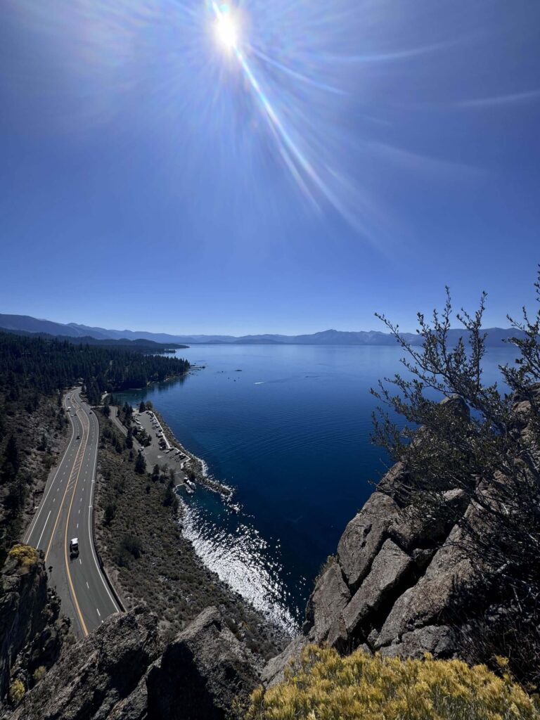
Cell Service and Navigation
Cell coverage is generally solid on the Nevada side of Highway 50 near Cave Rock. Signal holds throughout the short trail. Download the AllTrails map as standard practice. The trail is short and clear, no navigation challenge. Having the waypoint loaded is most useful for finding the pullout from the highway at the right moment when approaching from South Lake Tahoe at highway speed.
What to Expect at Cave Rock
The Formation
Cave Rock is a volcanic plug, the solidified core of an ancient volcano that remained after softer surrounding material eroded away. The formation is roughly 360 feet tall and extends into the lake on the western face. The trail climbs the eastern side of the formation through rocky terrain to the viewpoint above. The volcanic rock has a different texture and character from the granite that defines most of the Tahoe Basin, darker, more porous, with layered evidence of the lava flows that built it.
The View
The viewpoint at the top of the short trail delivers a wide Lake Tahoe panorama facing west. The lake spreads from south to north with the Sierra Nevada ridge filling the western skyline and the California shoreline visible on the far side. South Lake Tahoe is visible to the south. To the east, the Nevada high desert extends toward Carson Valley. The elevated position above the highway and the lake surface gives the view a different angle than most lakeside overlooks, looking down at the water rather than across it.
Cultural Significance
Cave Rock has been a sacred site for the Washoe people for thousands of years. In their tradition, Da ow a ga is a spiritually powerful place used for ceremonies, vision quests, and as a landmark connecting the tribe to the lake. The Forest Service banned rock climbing at Cave Rock in 2008 following a long legal process in which the Washoe Tribe successfully argued that climbing damaged the cultural integrity of the site. That decision is worth knowing before you visit. The trail is open for hiking and viewing. Climbing on the formation is prohibited. Visiting with respect for the Washoe people’s relationship to this place is not optional.
Trail Difficulty and Length
Cave Rock Trail is approximately 0.8 miles out and back with around 100 feet of elevation gain. It is rated easy and appropriate for most visitors. The terrain is rocky and requires attention on the volcanic rock surface, which has different traction characteristics than granite. Sturdy shoes are worth it over sandals. The trail is short enough to complete in 30 to 45 minutes at a relaxed pace. The viewpoint has some exposure near the edge, stay back from the rim. 
Dog Friendly?
Dogs are allowed on leash at Cave Rock. The short trail is manageable for most dogs. The rocky volcanic surface requires attention on dog paws, different from the granite trails elsewhere in the basin. Keep dogs well back from the cliff edges at the viewpoint. No water sources on trail, bring water for your dog. Pack out all waste.
What to Bring
Water, even for a sub-mile trail. The site is exposed and the Nevada side of the lake runs warm. Sunscreen and a hat. Sturdy shoes with grip for the volcanic rock surface. A camera. The lake panorama from the top rewards a wide lens. The formation itself, with the lake visible through the tunnel passage below, is a strong close-up composition.
Best Time to Visit Cave Rock
Cave Rock is accessible year-round. Highway 50 stays open through winter, unlike some of the western shore routes. Summer brings the clearest lake views and the highest visitor numbers. The site is busiest in July and August on weekends. Morning visits before 9 a.m. give you quieter conditions. Fall is excellent, cooler temperatures, thinner crowds, and the Nevada desert visible to the east beginning to shift into its fall character. Winter visits are quiet and occasionally dramatic when snow covers the surrounding hills while the lake stays deep blue. Sunrise from Cave Rock with the light hitting the California Sierra Nevada across the water is the best single photography window at this location.
Rules and Regulations
Cave Rock is within the Lake Tahoe Basin Management Unit under USDA Forest Service management. Stay on the designated trail. Rock climbing on Cave Rock is prohibited. This ban was established in 2008 following a legal decision recognizing the Washoe Tribe’s claim that climbing damaged the cultural integrity of their sacred site. Do not climb on the formation under any circumstances. No campfires. Pack out all waste. Respect the cultural significance of the site throughout your visit. Leave No Trace.
Where to Stay Near South Lake Tahoe
South Lake Tahoe is about 10 minutes west of Cave Rock on Highway 50 with a full range of lodging. Marriott Bonvoy covers properties in the South Lake Tahoe area. Hilton Honors has options in the South Shore corridor. Zephyr Cove Resort, about a mile from Cave Rock on Highway 50, has lakefront lodging, camping, and boat rentals directly on the Nevada shore. 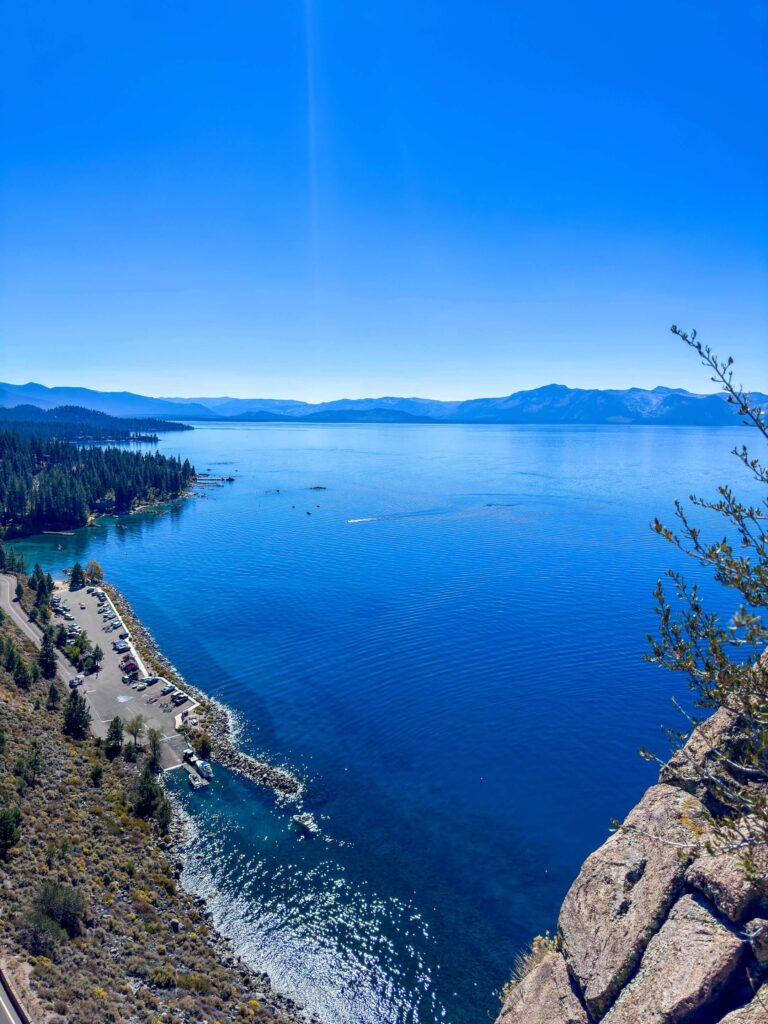
Camping Nearby
Zephyr Cove Resort has a campground directly on the lake about a mile from Cave Rock, one of the most convenient lakefront camping options on the Nevada side. Nevada Beach Campground further north on the Nevada shore has developed sites with beach access through the USDA Forest Service. South Lake Tahoe’s Camp Richardson on the California side is the largest developed campground option in the broader area. Reserve all developed sites through recreation.gov for summer stays.
Nearby Adventures
The Stateline Overlook Trail is about 10 minutes west on the Nevada side, a 1.5-mile moderate trail through pine forest to a two-state Lake Tahoe panorama from the Kingsbury Grade area. The Castle Rock hike above Kingsbury Grade is 3.5 miles with 700 feet of gain to granite formations and simultaneous views of Lake Tahoe and Carson Valley. Zephyr Cove Beach a mile from Cave Rock has kayak and paddleboard rentals for on-water exploration. The Sand Harbor Clear Kayak Tour is about 15 minutes north on Nevada Route 28, the best guided water experience near the Nevada shore. The Tallac Historic Site on the California side covers the early settlement history of the Lake Tahoe Basin in a different cultural register from Cave Rock’s indigenous significance, worth combining on a full Tahoe day.
Plan This Hike
AllTrails has Cave Rock documented with GPS track and current conditions. The trail is short and the navigation is simple, but having the trailhead location loaded helps with the Highway 50 pullout approach at speed. Plan your hike on AllTrails here. 
Chase the Quiet
I stood at the Cave Rock viewpoint for a while on a fall morning, the lake below still and blue, the California Sierra Nevada catching the first direct light from the east. Thinking about the Washoe people standing in this same place for thousands of years, using this specific formation as a point of connection to something much older and larger than a day hike. That’s a different kind of quiet than the geological quiet of the canyon country I usually chase. Worth sitting with.
Support the Adventure
To make your walls less boring, check out my photography portfolio and bring a piece of the wild and my story into your home. If you’d like to fuel future adventures, you can donate a coffee on Ko-Fi. Every cup keeps me chasing sunrises and stories. When you shop using my affiliate links, every click helps support this blog at no extra cost to you. It’s a small way to keep Unicorn Adventure alive and kicking while I keep exploring. Subscribe to my mailing list for future updates, new stories, and behind-the-scenes adventures. Stay connected with me on Instagram and Facebook for more photos and daily inspiration. Thanks for being part of the journey, Unicorn Squadron!

Theo Maynard is a landscape photographer and adventure blogger based in Salt Lake City. He chases remote desert and mountain light across the American West, documents it all solo, and shares the journey through Unicorn Adventure. He’s on the autism spectrum, and that’s not a footnote, it’s the whole story. He creates to inspire others to get outside, chase what lights them up, and live their best possible life. Unapologetically himself.