

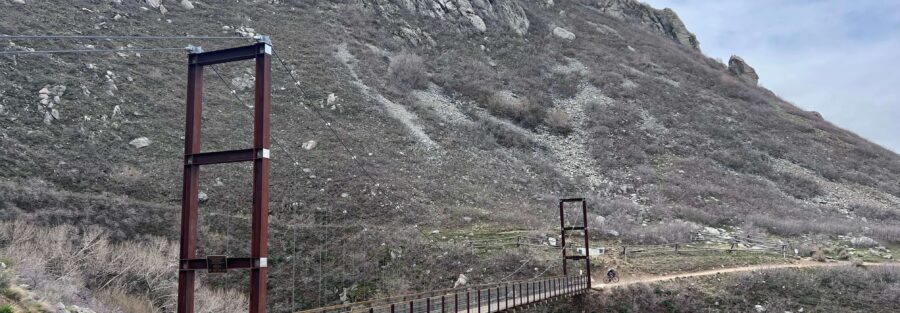
Most trails end at a viewpoint or a waterfall. Bear Creek ends at a suspension bridge hanging over a canyon. That’s a better idea. The Bear Creek Suspension Bridge Trail starts at Orson Smith Park in Draper, a short drive from the I-15 corridor, and climbs through scrub oak and sagebrush foothills before dropping to a suspension bridge spanning Bear Creek canyon. The round trip is 2.3 miles with 400 feet of gain. It’s family-friendly, dog-friendly, and ends at a structure that looks genuinely impressive hanging over the creek below. The trail connects to the Bonneville Shoreline Trail past the bridge for hikers who want to extend the day. I’ve done this trail with people who don’t normally hike. The suspension bridge is the kind of destination that earns its reputation with anyone regardless of hiking experience. Here’s what you need to hike Bear Creek Suspension Bridge.
Quick Facts
| Trail Name | Bear Creek Suspension Bridge Trail |
| Location | Orson Smith Park, Draper, Utah |
| Coordinates | 40.5218, -111.8334 |
| Distance | 2.3 miles (round trip) |
| Elevation Gain | 400 feet |
| Difficulty | Moderate |
| Time | 1.5-2.5 hours |
| Dogs Allowed | Yes (on leash) |
| Fee | None |
| View on Alltrails | |
How to Get There
From I-15, take the exit at 12300 South toward Draper. Head east on 12300 South, which becomes Highland Drive. Continue east on Highland Drive to 2000 East and turn right. Follow the road to Orson Smith Park. The parking lot and trailhead are at the park. Drive time from Salt Lake City is about 25 to 30 minutes.
Parking Information
Orson Smith Park has a free parking lot with restrooms and picnic areas, which makes it one of the better-equipped trailheads in the Draper trail network. The lot is spacious but fills on weekend mornings from spring through fall. Arrive before 8 a.m. on busy weekends to guarantee a spot. The facilities at the park are a meaningful convenience before a trail where there are no services past the trailhead. 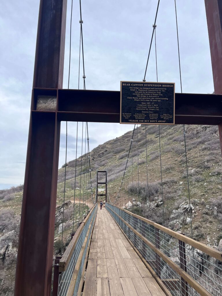
Cell Service and Navigation
Cell service is generally reliable in the Draper corridor close to I-15. It can weaken on the upper trail sections as you move into the foothills. Download your map offline through AllTrails before leaving as a backup. The trail is well-marked through the main approach. The descent to the bridge and the Bonneville Shoreline Trail junction past it are the sections where a GPS track adds the most value. Check the forecast before heading out. The exposed foothills get hot fast in summer.
What to Expect on Bear Creek Suspension Bridge Trail
The Foothill Approach
The trail starts at Orson Smith Park and climbs through scrub oak and sagebrush-covered foothills. The views open quickly. The Salt Lake Valley spreads west and the Wasatch Range rises to the east. The trail is wide and well-worn through the lower section. The vegetation is classic Utah high-desert foothills, dry and open, which means full sun exposure and a heat buildup that accelerates in the late morning. The approach is the more gradual section of the hike before the terrain changes near the canyon.
The Suspension Bridge
The trail steepens as it approaches Bear Creek Canyon and the suspension bridge comes into view. The final section drops down to the bridge level. The bridge spans the canyon with Bear Creek running below it. Walking across it delivers a different kind of view than a static overlook. The canyon drops away on both sides. The structure itself is photogenic from either end and from below if you can find an angle down to the creek. Past the bridge the trail connects to the Bonneville Shoreline Trail, which runs north and south along the ancient Lake Bonneville shoreline and allows significant additional mileage for hikers who want to extend the day.
Trail Difficulty and Length
Bear Creek Suspension Bridge Trail is 2.3 miles roundtrip with 400 feet of elevation gain. The moderate rating is accurate: the foothill approach is manageable and the descent to the bridge is steep but brief. Budget 1.5 to 2.5 hours with time at the bridge. The trail is suitable for families with children of various ages and for beginners with reasonable fitness.
Dog Friendly?
Yes. Dogs are welcome on leash throughout the Draper trail network. The foothill terrain is exposed and heats up fast in summer. Bring more water than you think your dog needs and start early on warm days. The suspension bridge itself is a novelty for dogs as much as it is for people. Keep them on leash on the bridge for obvious reasons. 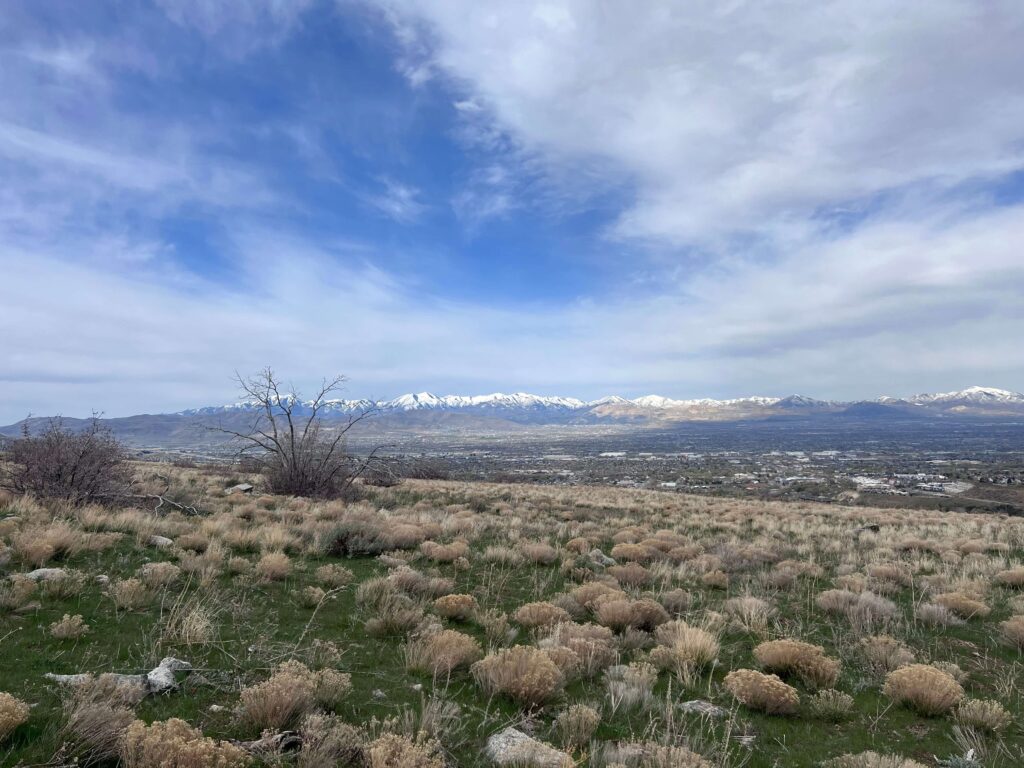
What to Bring
At least 1.5 liters of water per person. The exposed foothills drain you faster than the short mileage suggests, especially in summer heat. Sunscreen and a hat for the open approach sections. Trail shoes with grip for the steep descent to the bridge. A camera for the bridge and canyon views. A wide-angle lens captures the full span and the canyon below. A phone with offline maps loaded if you plan to continue on the Bonneville Shoreline Trail past the bridge. Trekking poles help on the steep descent section for anyone with knee concerns.
Best Time to Hike Bear Creek Suspension Bridge
Spring (April through June) and fall (September through October) are the best windows. Spring brings wildflowers to the foothills and the creek runs fuller below the bridge. Fall delivers clear views and manageable temperatures. Summer is hot on the exposed approach. Start before 8 a.m. in summer without exception. Winter keeps the trail accessible but ice on the steep descent to the bridge requires microspikes for safe footing. For photography, early morning light catches the Wasatch peaks from the approach section in warm tones. The bridge photographs best from the canyon floor if accessible, or from either end of the span. The canyon walls catch late afternoon light at certain times of year that makes the rock glow. A wide-angle lens from the center of the bridge gets the full canyon drop in both directions.
Rules and Regulations
Bear Creek Suspension Bridge Trail is managed through the Draper City parks and trail system. No fee, no permit required. Dogs on leash at all times. Leave No Trace applies: pack out everything and stay on established trails. The Bonneville Shoreline Trail connection is managed by Utah Open Lands and Salt Lake County in this area. Check Draper City’s trail system website for any current closures or conditions before heading out.
Where to Stay Near Draper
Draper and South Jordan have chain lodging along the I-15 corridor within 10 to 15 minutes of Orson Smith Park. For hotel points check Marriott Bonvoy, IHG Rewards, and Hilton Honors. Salt Lake City is 25 to 30 minutes north with broader inventory.
Camping Nearby
No camping at Orson Smith Park. Big and Little Cottonwood Canyons, 15 to 20 minutes north on Wasatch Boulevard, have established campgrounds through Recreation.gov. Redman Campground in Big Cottonwood and Albion Basin in Little Cottonwood are the closest established options for hikers who want to camp and access multiple trails in the area.
Nearby Adventures
The Bear Creek trail connects to the Bonneville Shoreline Trail at the bridge, which runs north and south along the ancient Lake Bonneville shoreline. It provides access to Ghost Falls Trail, which adds a waterfall destination to the day for hikers who want additional mileage on the Bonneville corridor. Corner Canyon’s trail network is in the same Draper foothills area with options ranging from easy loops to technical mountain bike routes that also work on foot. The Alien Tower via Deer Ridge Trailhead is another Draper foothill option at 2.5 miles and 500 feet of gain, ending at a distinctive telecom tower on the ridge with full valley views. A short drive north on Wasatch Boulevard opens up the full Wasatch canyon system: Bell Canyon Lower Falls (4.8 mi / 1,600 ft) in Sandy and Lisa Falls (0.2 mi / 75 ft) in Little Cottonwood Canyon are accessible within 20 minutes. For a total change of landscape, the Escalante area a few hours south delivers desert canyon hiking in a different category. Lower Calf Creek Falls (6.1 mi / 531 ft) and Escalante Natural Bridge (4.4 mi / 291 ft) are worth the drive south when you want desert instead of Wasatch foothills. Loveland Living Planet Aquarium in Sandy is a strong family option within 15 minutes, with marine exhibits and interactive features. Draper City Park has additional recreational facilities close to the trailhead for families who want to extend the morning past the hike.
Plan This Hike
AllTrails has Bear Creek Suspension Bridge Trail with a downloadable map and recent user conditions. Checking recent reports is useful for current conditions on the steep descent section and the bridge access, which can be affected by seasonal maintenance. View on Alltrails AllTrails Pro is worth it if you’re planning to extend the hike onto the Bonneville Shoreline Trail, where offline maps help navigate the junction network north and south of the bridge.
Chase the Quiet
A suspension bridge over a canyon creek in the Draper foothills is not where you expect to find something genuinely worth the drive. The views on the approach are solid Wasatch Front foothill views, which are good but familiar. Then the bridge appears and the canyon drops away below it and the creek is down there and the structure is swaying slightly in the wind and suddenly the short trail earned its reputation. That’s the deal with Bear Creek.
Support the Adventure
To make your walls less boring, check out my photography portfolio and bring a piece of the wild and my story into your home. If you’d like to fuel future adventures, you can donate a coffee on Ko-Fi. Every cup keeps me chasing sunrises and stories. When you shop using my affiliate links, every click helps support this blog at no extra cost to you. It’s a small way to keep Unicorn Adventure alive and kicking while I keep exploring. Subscribe to my mailing list for future updates, new stories, and behind-the-scenes adventures. Stay connected with me on Instagram and Facebook for more photos and daily inspiration. Thanks for being part of the journey, Unicorn Squadron!

Theo Maynard is a landscape photographer and adventure blogger based in Salt Lake City. He chases remote desert and mountain light across the American West, documents it all solo, and shares the journey through Unicorn Adventure. He’s on the autism spectrum, and that’s not a footnote, it’s the whole story. He creates to inspire others to get outside, chase what lights them up, and live their best possible life. Unapologetically himself.