Most hikers in Grand Staircase-Escalante are heading to Calf Creek or Zebra Canyon. Bighorn Canyon gets the people who looked at the map and drove 30 miles further.
Bighorn Canyon sits well down Hole-in-the-Rock Road, deep inside the monument, away from the clusters of hikers that hit the more famous trailheads off Highway 12. The route drops into the head of a narrow canyon and follows it between rising sandstone walls for 6.0 miles round trip. It’s quiet out here in a way that even other remote Utah trails aren’t.
Quick Facts
| Trail Name | Bighorn Canyon Trail |
| Location | Grand Staircase-Escalante NM, near Escalante, Utah |
| Coordinates | 37.6777° N, 111.4826° W |
| Distance | 6.0 miles (round trip) |
| Elevation Gain | 390 feet |
| Difficulty | Moderate |
| Time | 3-5 hours |
| Dogs Allowed | Yes (on leash) |
| Fee | None |
| AllTrails | View on Alltrails |
How to Get There
From Escalante, head east on Highway 12 for about 5 miles and turn south onto Hole-in-the-Rock Road. Follow the dirt road for approximately 30 miles to the small signed Bighorn Canyon trailhead on your right. This is a long drive on primitive road. High clearance is strongly recommended and four-wheel drive is the safer choice, especially after rain when the surface turns to slick clay. The road is generally passable in dry conditions for most vehicles, but 30 miles of washboard is not a fun experience without decent clearance. Allow 45 to 60 minutes from Highway 12 just for the drive in.
Parking Information
Parking is a small unpaved pull-off at the trailhead. Space for a few vehicles. No facilities, no fee, nothing. Bring everything you need from Escalante. This is as remote as it sounds. Lock your vehicle and start early to make sure you have full daylight for the hike. The drive back out on Hole-in-the-Rock Road takes time, and you don’t want to be navigating it in the dark.

Cell Service and Navigation
No cell service. You lose signal well before you reach the trailhead on Hole-in-the-Rock Road and it doesn’t come back until you’re near Highway 12 on the return. Download your maps offline through AllTrails or Gaia GPS before leaving Escalante. The canyon route requires some route-finding, particularly deeper in, and you’ll want a GPS track to reference. Flash flood risk in the canyon is real. Check weather for the full watershed before driving out. The 30-mile drive back on a muddy Hole-in-the-Rock Road is its own emergency.
What to Expect on Bighorn Canyon Trail
The Approach
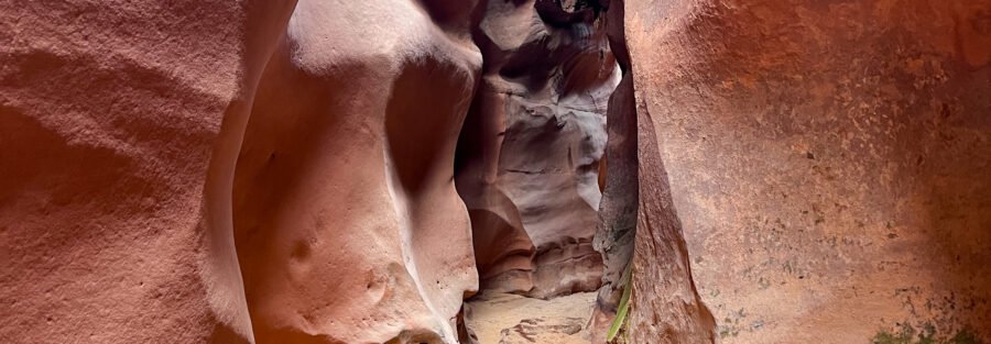
The trail starts at the rim and drops into the canyon almost immediately. From the trailhead you descend into the head of the canyon and the walls start rising around you as you push deeper. The canyon floor alternates between sand, slickrock, and scattered vegetation. The route narrows as you go, and the walls climb higher. It’s the kind of terrain that rewards patience because the deeper you get, the better it looks.
Bighorn Canyon doesn’t have a single dramatic feature to anchor it the way Calf Creek has its waterfall or Zebra has its banded slot. What it has is sustained canyon beauty without the crowds. The sandstone walls shift through red, orange, and pink depending on the light. Sandy sections slow your pace. Occasional scrambles break up the walk. Water and mud may appear depending on recent rain. The solitude is consistent. This is the monument’s quieter side, and if that’s what you came for, it delivers.

Trail Difficulty and Length
Bighorn Canyon is 6.0 miles round trip with 390 feet of elevation gain. It’s rated moderate. The sandy terrain makes the mileage feel longer than it reads, and some route-finding toward the canyon’s deeper sections adds a navigational layer that straightforward trails don’t have. It’s not technical scrambling, but it’s not a groomed path either. Previous desert hiking experience helps. Budget 3 to 5 hours depending on pace and exploration. Flash flood risk in a slot canyon environment means checking weather is mandatory, not optional.
Dog Friendly?
Yes. Dogs are welcome on leash. Some narrow canyon sections and potential water in the floor require a bit of extra management with a dog, but nothing that makes it impractical. Bring more water than you think they need. There’s no shade in the open sections and the sandstone holds heat.

What to Bring
At least 2 to 3 liters of water per person. The hike is remote and exposed and there’s no water source on trail you can count on. Sun protection for the approach and open sections. Shoes with solid grip for the slickrock scrambles and sandy terrain. A GPS device or phone loaded with offline maps is non-negotiable at this distance from the highway. Bring a headlamp and a snack for the turnaround point. Tell someone where you’re going and when you expect to be back. This is genuine backcountry.
Best Time to Hike Bighorn Canyon
Spring (April through June) and fall (September through October) give you the best conditions. Temperatures are manageable and the canyon light is exceptional. Summer is brutal with no shade and the drive in on Hole-in-the-Rock Road in high heat adds to the toll. Start before 7 a.m. if you’re going in summer. Winter is possible but cold canyon temperatures and the potential for ice on the slickrock sections make it a harder day.
For photography, late afternoon light is the move in Bighorn Canyon. The low angle sun hits the canyon walls and lights up the color banding in the sandstone. The canyon’s east-west orientation means morning light hits the south-facing walls and late light hits the north-facing walls. Walking back out in golden hour with the walls lit up from the side is a strong finish to a long day.
Rules and Regulations
Bighorn Canyon is BLM land managed as part of Grand Staircase-Escalante National Monument. No permits, no fees. Leave No Trace applies fully: pack out everything, don’t disturb the canyon floor or walls, and don’t add or move cairns used for navigation. Flash flood closures happen. Check current conditions with the Escalante Interagency Visitor Center before making the 30-mile drive out. Also verify Hole-in-the-Rock Road conditions, especially after any recent precipitation.
Where to Stay Near Escalante
Escalante is your base for Bighorn Canyon. Entrada Escalante Lodge and Canyon Country Lodge are solid in-town options.
Camping Nearby
Hole-in-the-Rock Road itself has dispersed BLM camping along its length. If you’re driving 30 miles in for a hike, camping near the trailhead and waking up already out there is the obvious play. Cedar Point, South Turkey, and Spencer Flat are all in the Grand Staircase area. No hookups, no reservations, serious sky.
The Calf Creek Recreation Area campground on Highway 12 is a reservable option closer to town, right at the Lower Calf Creek Falls trailhead. Book through recreation.gov. It fills fast on weekends.
Nearby Adventures
If you’re already driving Hole-in-the-Rock Road, Zebra and Tunnel Slot Canyons are accessible about 8 miles down the road from Highway 12, well before Bighorn Canyon. Covering 6.6 miles with 469 feet of gain through some of the most visually striking slot terrain in the monument, they make a natural pairing with a Bighorn day. Dry Fork Narrows with Peekaboo and Spooky Slot Canyons are further down the road and add 6.0 miles with 656 feet of gain through even tighter passages.
Back near the highway, Lower Calf Creek Falls (6.1 mi / 531 ft) and Escalante Natural Bridge (4.4 mi / 291 ft) are both worth doing on a rest day or before you commit to the long Hole-in-the-Rock drive. The Cosmic Ashtray via Volcano Trail (7.6 mi / 810 ft) takes a different road east of Escalante but delivers a similarly remote, crowd-free experience on open slickrock.
For scenic driving, Moki Dugway is a short drive south and one of the most dramatic roads in Utah. The Burr Trail runs east from Boulder and gives you big canyon views with minimal washboard.
Off the trail, the Anasazi State Park Museum in Boulder has genuine Ancestral Puebloan artifacts and a reconstructed village. The Escalante Petrified Forest State Park is an easy rest-day stop with an interpretive loop through fossilized wood and badlands.
Plan This Hike
AllTrails has the Bighorn Canyon Trail with a downloadable map and recent user conditions. Given the navigation demands deeper in the canyon and the remote location, downloading the offline map before you lose signal on Hole-in-the-Rock Road is not optional. Check recent reports for water or mud conditions in the canyon floor.
AllTrails Pro is worth it for backcountry desert routes where offline navigation is the whole game. This is exactly the kind of hike it was built for.
Chase the Quiet
Thirty miles down Hole-in-the-Rock Road with no other vehicles in the rearview mirror. An empty trailhead. A canyon that narrows as you walk deeper and the walls climb higher and the sky shrinks to a strip overhead. Nobody else in it. That’s a specific kind of gift. The monument is full of trails that reward the extra effort, and Bighorn Canyon is one of the ones that rewards it most.
Support the Adventure
To make your walls less boring, check out my photography portfolio and bring a piece of the wild and my story into your home.
If you’d like to fuel future adventures, you can donate a coffee on Ko-Fi. Every cup keeps me chasing sunrises and stories.
When you shop using my affiliate links, every click helps support this blog at no extra cost to you. It’s a small way to keep Unicorn Adventure alive and kicking while I keep exploring.
Subscribe to my mailing list for future updates, new stories, and behind-the-scenes adventures.
Stay connected with me on Instagram and Facebook for more photos and daily inspiration.
Thanks for being part of the journey, Unicorn Squadron!

Theo Maynard is a landscape photographer and adventure blogger based in Salt Lake City. He chases remote desert and mountain light across the American West, documents it all solo, and shares the journey through Unicorn Adventure. He’s on the autism spectrum, and that’s not a footnote, it’s the whole story. He creates to inspire others to get outside, chase what lights them up, and live their best possible life. Unapologetically himself.