

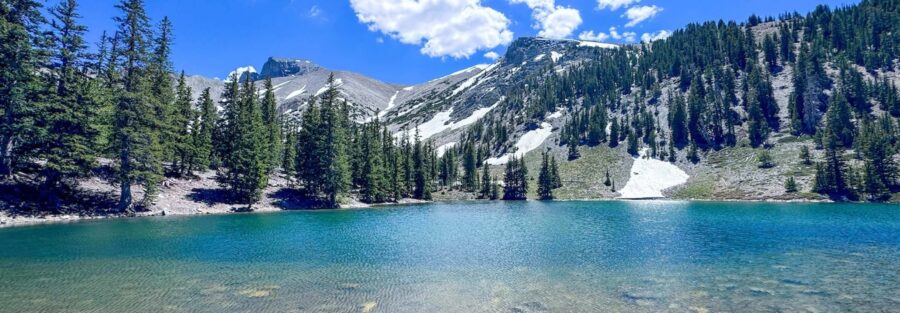
The oldest living trees on Earth are in Nevada, and most people drive past them on US-50 without knowing it. Great Basin National Park sits 70 miles east of Ely in the Snake Range, and at the top of Wheeler Peak Scenic Drive, the Bristlecone and Alpine Lakes Loop gives you access to bristlecone pines that have been alive for 3,000 to 5,000 years, two alpine lakes sitting in the shadow of Wheeler Peak, and one of the better 5-mile trail loops in the American West. The park is genuinely uncrowded by national park standards, which makes everything about this hike easier.
I drove to Great Basin on a route that put me on US-50, the Loneliest Road in America, across Nevada. The Wheeler Peak Scenic Drive comes off that highway and climbs into a completely different world. By the time you park at the Summit Trailhead and start walking through the bristlecone grove, the Great Basin salt flats you drove through to get here feel like a different country. The transition is as complete as any in the American West. Ancient trees. Alpine lakes. Granite peaks. All accessible on a 5-mile loop.
This guide covers the Bristlecone and Alpine Lakes Loop: what the terrain actually involves, how to time a visit to Great Basin, and what else to do in one of the least-visited national parks in the continental US.
Quick Facts
| Trail Name | Bristlecone and Alpine Lakes Loop (Stella Lake, Teresa Lake) |
| Location | Great Basin National Park, near Baker, Nevada |
| Coordinates | 39.0102 N, 114.3062 W (Summit Trailhead) |
| Distance | 5.3 miles (loop) |
| Elevation Gain | 1,020 feet |
| Difficulty | Moderate |
| Time | 3-4 hours |
| Dogs Allowed | No |
| Fee | Free (no entry fee at Great Basin National Park) |
| View on AllTrails | |
How to Get There
Great Basin National Park is located near Baker, Nevada, on US-50 in eastern Nevada. From Baker, follow NV-487 south for about 5 miles to the park visitor center. From the visitor center, take Wheeler Peak Scenic Drive for approximately 12 miles as it climbs from the basin floor to the Wheeler Peak Campground and Summit Trailhead parking area at around 10,000 feet. The scenic drive gains significant elevation and the views of the Snake Range and the Great Basin below are worth going slowly for.
From Salt Lake City, Great Basin is about 4 hours west on I-15 south and US-50 west. From Reno, it’s roughly 5 hours east on US-50. From Las Vegas, plan about 4.5 hours north on I-15 and east on US-50. Great Basin is one of the least-visited national parks in the continental US partly because it sits well off the major tourism corridors. That remoteness is part of the appeal.
No entry fee. No timed entry reservation. Great Basin National Park is free to enter and visit, which is uncommon among national parks of this quality. The Wheeler Peak Scenic Drive closes in winter when the upper sections become impassable. Check road status with the park before your visit in spring or late fall.
Parking Information
Parking at the Summit Trailhead near Wheeler Peak Campground is free and generally has adequate space. The lot fills faster on summer weekends and during peak season in July and August, but Great Basin’s overall visitation is low enough that arriving by 8 or 9 a.m. is usually sufficient even in summer. The trailhead has restrooms and informational signage.
Note that Wheeler Peak Scenic Drive is a 12-mile mountain road that takes time to navigate. Factor that into your schedule for an early start.
Cell Service and Navigation
Cell coverage is absent in the upper reaches of Wheeler Peak Scenic Drive and at the Summit Trailhead. Download AllTrails or the NPS Great Basin app offline before leaving Baker or the visitor center, where Wi-Fi may be available.
The loop trail is well-marked with signs at key junctions. The Stella Lake and Teresa Lake junctions are clearly signed. Navigation isn’t the challenge here. The primary wayfinding decision is which direction to run the loop, which you can determine based on where you want the bristlecone grove and where you want the lake sections relative to your energy level at different parts of the hike.
What to Expect on the Bristlecone and Alpine Lakes Loop
The Bristlecone Grove
The bristlecone pine section is the most distinctive part of this hike and what separates it from a standard alpine lake loop. These trees are the oldest living organisms on Earth, some of them between 3,000 and 5,000 years old. They grow in the harshest conditions, high elevation, thin rocky soil, minimal precipitation, and the adversity shows in their form: gnarled, twisted, dense-grained wood that resists decay and insect damage through sheer density.
Walking through the grove is a different kind of hiking experience. The trees don’t form a dense canopy. The grove is open and the light comes through at angles. The oldest trees have that specific quality of extreme old age where the form stops looking like a living thing in the conventional sense and starts looking like something that’s been carved by weather and time rather than grown. Give yourself more time in the grove than you think you need. There’s a lot to look at slowly.
Stay on the trail in the bristlecone grove. The root systems of these trees extend widely and are easily damaged by foot traffic. A single careless step can damage a root that took centuries to establish. The NPS takes trail-adherence in the grove seriously.
Stella Lake and Teresa Lake
Stella Lake is the higher of the two lakes, sitting in a small cirque just below the Wheeler Peak ridgeline. It’s compact and reflective, framing Wheeler Peak above it when there’s no wind. Teresa Lake sits lower on the loop, larger and more open with meadow terrain around the inlet side.
Both lakes are cold and clear. Photography at Stella Lake is best in morning when the eastern light hits the cirque walls. Teresa Lake has a more open aspect and works at multiple times of day. The two lakes combined with the bristlecone grove and the Wheeler Peak backdrop create a visual range on this trail that few 5-mile loops in the American West can match.
Trail Difficulty and Length
This trail is 5.3 miles with 1,020 feet of elevation gain.
Moderate is accurate. The trail starts at around 10,000 feet and climbs to the upper sections near the bristlecone grove before descending to the lakes. The elevation itself is the primary difficulty factor, not the terrain. Hikers not acclimatized to 10,000-plus feet will feel the altitude on the ascent sections. Take it slow if this is your highest elevation hike.
Budget 3-4 hours for the full loop at a relaxed pace with time in the bristlecone grove and at both lakes. Hikers who move quickly and don’t linger can do it in 2.5 hours. The grove rewards lingering.
Dog Friendly?
No. Great Basin National Park prohibits pets on all trails, including the Bristlecone and Alpine Lakes Loop. Dogs are permitted in parking areas, campgrounds, and along paved roads, but must stay leashed and off trail surfaces. This is consistent with most national park pet policies.
The park visitor center staff can advise on areas outside the park where dogs are permitted. The BLM land surrounding Great Basin has some accessible terrain, though the park’s alpine trail system is the primary draw in the area.
What to Bring
Water: the trail starts at 10,000 feet and the alpine air at that elevation is drier than lower elevations. Bring at least 2 liters per person. There’s no water on the trail itself; Stella and Teresa Lakes are available sources requiring treatment or filtration.
Layers are essential. Even in July, morning temperatures at 10,000 feet can be in the 40s. Afternoon thunderstorms build quickly over the Snake Range in summer. A rain shell and a mid-layer belong in the pack regardless of the morning forecast. Sun protection for the exposed sections above tree line.
Sturdy trail shoes or hiking boots. The trail is well-maintained but rocky in sections, particularly around the bristlecone grove and near Stella Lake.
For photography: wide-angle for the lake reflections and grove compositions, longer focal length for bristlecone bark and branch detail. The grove rewards close-up work as much as wide landscape shots. Overcast days actually photograph well in the grove since the diffuse light brings out the texture of the bark without harsh shadows.
Best Time to Hike the Bristlecone and Alpine Lakes Loop
Late June through September is the reliable window. Wheeler Peak Scenic Drive typically opens by late June depending on snowpack, and the upper trailhead area is accessible through October in most years. Check road status before your visit in shoulder seasons.
July and August are peak season but Great Basin’s overall visitation is low enough that the trail rarely feels crowded even in summer. Afternoon thunderstorms are the main summer variable. Start the hike early and plan to be in the lower sections of the loop by 1-2 p.m. on days when afternoon storms are possible.
September is excellent. Temperatures drop, afternoon storm frequency decreases, and the light on the Snake Range is excellent in the lower-angle fall sun. The aspens lower on the scenic drive turn in late September, adding color to the approach drive.
For photography: sunrise at Stella Lake requires reaching the trailhead before dawn and hiking in dim light, but the early morning reflection and the eastern light on Wheeler Peak above the lake make it worth the effort. Late afternoon at Teresa Lake captures western light on the open meadow and surrounding peaks. The bristlecone grove photographs well at any low-angle light time of day.
Rules and Regulations
Stay on the designated trail in and around the bristlecone grove. Root damage from off-trail foot traffic is real and long-lasting. These trees are irreplaceable. The NPS posts signage about staying on trail in the grove and enforces it.
Do not touch or carve the bristlecone pines. Do not remove wood, bark, or any natural material from the grove. Pack out all trash. No pets on the trail. No drones without a special use permit.
Great Basin National Park is designated as an International Dark Sky Park with some of the darkest skies in the continental US. If visiting for night photography or stargazing, bring only red-light headlamps in the campgrounds and be aware of other visitors’ dark sky experience. Fires are permitted only in designated fire rings at campgrounds.
Where to Stay Near Baker
Baker is the nearest town, a small community on US-50 about 5 miles from the park entrance. Lodging in Baker itself is limited to a handful of small motels and the Border Inn, which sits right on the Nevada-Utah state line on US-50.
For more lodging options, Ely is about 70 miles west on US-50 and has hotels and chain lodging with more availability.
Camping Nearby
Wheeler Peak Campground is the closest developed campground to the Summit Trailhead, sitting at 9,886 feet right at the base of the trail system. Reservations through recreation.gov during peak season. Camping at Wheeler Peak means a zero-drive morning start to the Bristlecone Loop, which is the best way to hit the grove at first light.
Lower Lehman Creek and Upper Lehman Creek Campgrounds are lower on Wheeler Peak Scenic Drive at higher temperatures and more moderate elevation, better for anyone sensitive to high altitude camping. Both operate seasonally. All campgrounds in Great Basin are reservation-based during peak season on recreation.gov.
Nearby Adventures
Wheeler Peak Summit Trail is the natural extension for hikers who want more than the loop. It climbs to the summit of Wheeler Peak at 13,063 feet via the Stella Lake Trail at 7.8 miles with 3,087 feet of gain. It’s a full, serious mountain day.
Baker Lake Trail at 3.6 miles with 872 feet of gain is an out-and-back hike to a backcountry lake on the south side of the park. A different character from the Summit Trailhead routes, quieter and more remote-feeling.
Lehman Caves is the park’s most popular non-hiking attraction. Guided tours run throughout the day and take you into a limestone cave system with stalactites, stalagmites, cave shields, and parachute formations. It’s one of the better cave tours accessible in the American West and runs year-round. Book tours at the visitor center or through recreation.gov in advance during peak season.
The night sky at Great Basin is genuinely exceptional. The park hosts regular astronomy programs at the visitor center and the campgrounds. If you’re timing a visit around dark sky conditions, the new moon period in summer and fall produces some of the best conditions in the continental US.
Plan This Hike
AllTrails has the Bristlecone and Alpine Lakes Loop mapped with offline capability. Download it at the visitor center or in Baker before driving Wheeler Peak Scenic Drive. Plan your hike on AllTrails and pull the offline map before you lose signal on the upper scenic drive.
Chase the Quiet
The bristlecone pines in Great Basin have been alive since before the Roman Empire. Some of them were already old when the pyramids were new. Walking through the grove and knowing that isn’t abstract information, it’s the kind of thing that makes the ordinary human sense of time feel like a rounding error. The trees don’t care about any of it. They’re just here, growing slowly in difficult conditions, doing what they’ve always done. That’s the version of ancient I keep coming back to the American West for. The kind that doesn’t need a sign.
Support the Adventure
To make your walls less boring, check out my photography portfolio and bring a piece of the wild and my story into your home.
If you’d like to fuel future adventures, you can donate a coffee on Ko-Fi. Every cup keeps me chasing sunrises and stories.
When you shop using my affiliate links, every click helps support this blog at no extra cost to you. It’s a small way to keep Unicorn Adventure alive and kicking while I keep exploring.
Subscribe to my mailing list for future updates, new stories, and behind-the-scenes adventures.
Stay connected with me on Instagram and Facebook for more photos and daily inspiration.
Thanks for being part of the journey, Unicorn Squadron!

Theo Maynard is a landscape photographer and adventure blogger based in Salt Lake City. He chases remote desert and mountain light across the American West, documents it all solo, and shares the journey through Unicorn Adventure. He’s on the autism spectrum, and that’s not a footnote, it’s the whole story. He creates to inspire others to get outside, chase what lights them up, and live their best possible life. Unapologetically himself.