The Burr Trail starts in the small town of Boulder, Utah, on a paved road that feels normal for about 30 miles. Then the pavement ends, the canyon walls close in, and the road starts doing things roads shouldn’t do. Long Canyon. The Waterpocket Fold. The Burr Trail Switchbacks, a series of tight, steep turns carved into the cliffs above the fold that will rearrange your sense of what a vehicle is capable of. By the time you reach Bullfrog Marina 66 miles later, you’ve driven through two of the most extraordinary geological features in the American Southwest.
Quick Facts
| Route | Burr Trail Road |
| Location | Grand Staircase-Escalante NM / Capitol Reef NP, Utah |
| Coordinates (Start) | 37.9013° N, 111.4251° W |
| Distance | 66 miles (Boulder to Bullfrog Marina) |
| Elevation Change | ~4,500 ft (net loss from Boulder to Lake Powell) |
| Difficulty | Moderate (high clearance required on dirt sections; 4WD recommended when wet) |
| Time | 3-6 hours depending on stops |
| Dogs Allowed | Yes (welcome in your vehicle on the drive) |
| AllTrails | View on Alltrails |
How to Get There
The Burr Trail starts in Boulder, Utah, at the eastern edge of town where the paved road transitions and heads toward Long Canyon. Boulder sits on Scenic Byway 12, one of the most celebrated drives in the state. If you haven’t driven Highway 12 already, the approach to Boulder from either Escalante or Torrey is worth slowing down for. The road crosses Hogsback Ridge with sheer drops on both sides and views into the Escalante canyon system below.
From Salt Lake City, the most direct route takes you south on I-15 to Highway 20, then east to US-89 and north on Highway 12 through Escalante. The drive from SLC to Boulder is about 4 hours.
From Escalante, Boulder is 26 miles northeast on Highway 12. The Anasazi State Park Museum is on the right as you enter town. The Burr Trail turnoff is at the eastern edge of Boulder, clearly signed.
Parking Information
Boulder has a small visitor area and parking near the Anasazi State Park Museum. For the Burr Trail itself, there’s no formal trailhead parking, the road is the destination. Pull-offs and viewpoints appear throughout the route for stopping and exploring.
Key stopping points with pull-offs: the Long Canyon viewpoints in the first 15 miles, the road shoulder near the Waterpocket Fold boundary, and the switchback overlook before the descent into the fold. Estes fit comfortably at all of them.
If you’re doing the full 66-mile one-way drive to Bullfrog, plan for a vehicle shuttle or be prepared to backtrack. Most people drive it as an out-and-back from Boulder, turning around at the Capitol Reef boundary or after the switchbacks.

Cell Service and Navigation
Cell service drops out almost immediately east of Boulder and doesn’t return until you’re well past the Capitol Reef section toward Hanksville. Plan for 50-plus miles with zero communication capability.
Download offline maps for the entire route before you leave Boulder. Google Maps works for the overall corridor. For detailed navigation on the dirt sections and any hiking stops, have AllTrails maps downloaded as well. A dedicated GPS unit is worth carrying on the full 66-mile drive.
Tell someone your itinerary, including your expected return time and the route you’re running. Mechanical trouble on the dirt sections of the Burr Trail means a long wait for help. Self-sufficiency is the baseline.
What to Expect on the Burr Trail
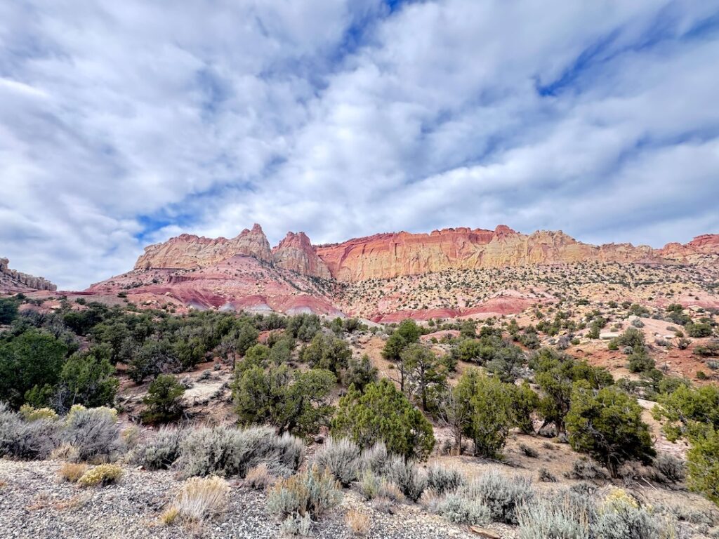
The first stretch out of Boulder runs paved for about 30 miles through the western edge of Grand Staircase-Escalante. The road eases into the canyon terrain gradually, then commits. Long Canyon is the first serious statement the Burr Trail makes. Sandstone walls rise on both sides of the road, banded in red and orange, and the canyon narrows enough in places that the walls are close enough to touch from the vehicle window.
Stop here. Get out and stand in the canyon. The acoustics are different inside Long Canyon, sound behaves differently when walls are that close and that tall. The morning light hits the east-facing walls first and the canyon glows warm for the first hour or two after sunrise. This is one of the best photography stops on the entire drive.
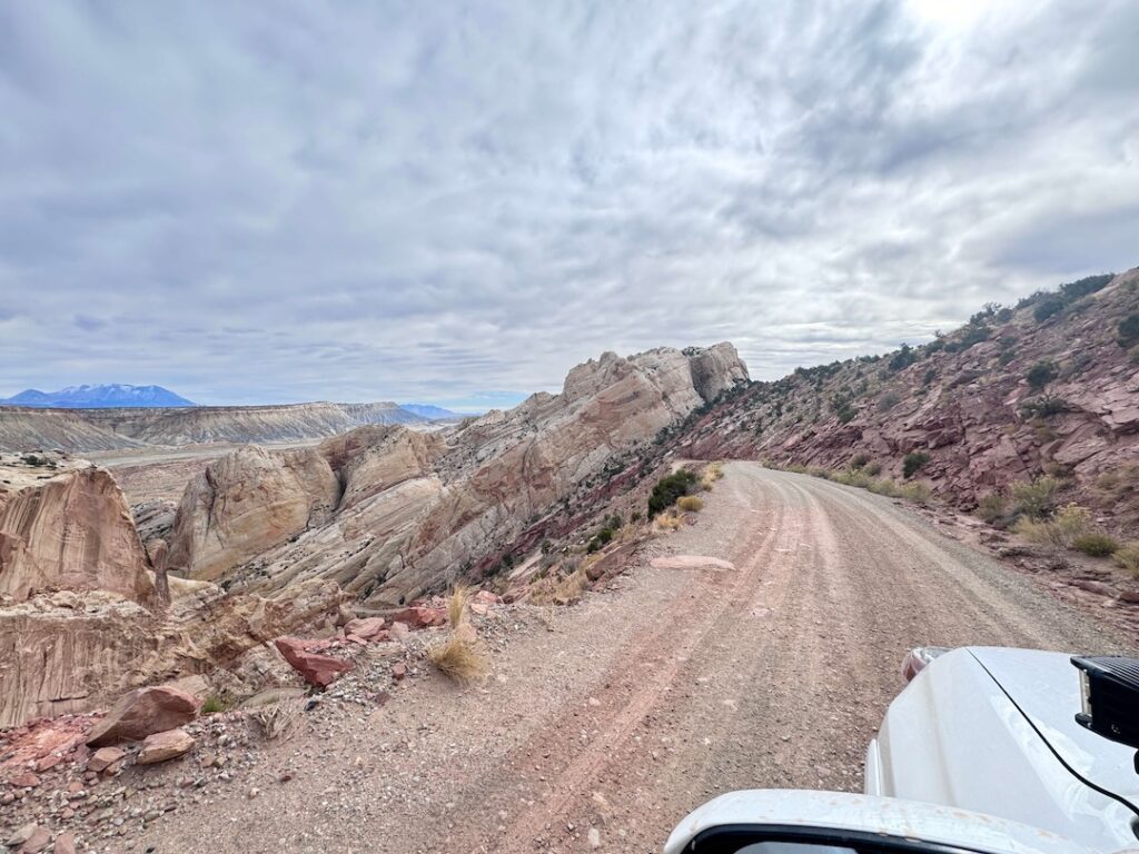
The pavement ends near the Capitol Reef National Park boundary. This is where the character of the drive changes.
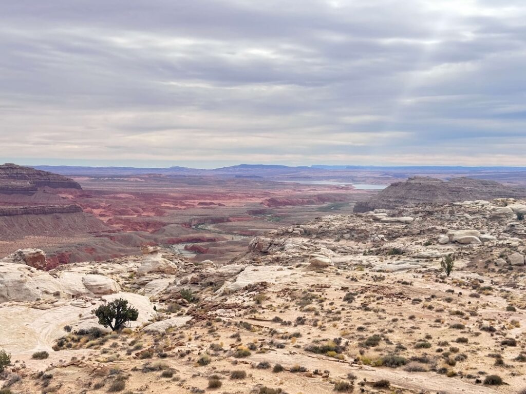
The Waterpocket Fold is a 100-mile-long monocline, a single massive step in the earth’s crust where rock layers on one side have been pushed up nearly a mile higher than the other. The Burr Trail crosses it directly. From the road, the fold’s layered geology is visible in cross-section: tilted bands of red, white, and brown sandstone, exposed by millions of years of erosion, stretching in both directions to the horizon.
This is where the dirt section begins and where high clearance becomes necessary. The road surface is graded but rough, with washboard in stretches and loose rock on steeper sections. Estes handles it confidently. A standard sedan risks high-centering or bottoming out on the rougher patches.
After rain, this section can become impassable. The clay-rich soil in the Capitol Reef corridor turns slick and unstable when wet. Check road conditions before committing to the dirt section.
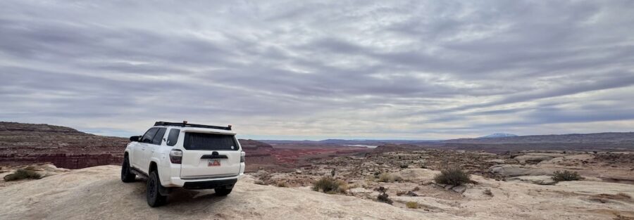
The Burr Trail Switchbacks are the reason people talk about this road. The descent into the Waterpocket Fold drops roughly 800 feet in about a mile on a series of tight, steep unpaved switchbacks carved directly into the cliff face. The road is single-lane with minimal guardrails and a view off the edge that clarifies your vehicle’s capabilities in a hurry.
Coming down, the fold opens below you and the canyon system stretches east in a panorama that’s genuinely hard to process all at once. Stop at the overlook above the switchbacks before you start the descent. The view from up top, looking east across the fold, is the best single frame the Burr Trail offers.
The switchbacks are passable in a capable high-clearance vehicle with a confident driver. They are not appropriate for large trailers, wide rigs, or inexperienced drivers. Take it slow. There’s no oncoming traffic issue if you move with intention.
The Burr Trail runs 66 miles from Boulder to Bullfrog Marina on Lake Powell. The western third is paved and easy in any vehicle. The eastern two-thirds are dirt, requiring high clearance and 4WD in wet conditions. The switchbacks add a skill component that goes beyond just clearance.
Most people driving the full route budget 4 to 6 hours with stops. If you’re turning around at the Capitol Reef boundary or after the switchbacks, figure 2 to 3 hours from Boulder. The return trip on the same route takes similar time in the opposite direction.
Difficulty is honest at moderate for the dirt sections in dry conditions and hard after rain. Don’t attempt the Capitol Reef section on a wet road unless you have serious 4WD capability and recovery gear.
Dog Friendly?
Dogs are welcome in your vehicle on the Burr Trail drive. The road itself has no restrictions.
For any hiking stops along the route, check the individual trailhead rules. Grand Staircase-Escalante NM is generally dog-friendly on established routes with leash requirements. Capitol Reef National Park has more restrictions on dogs in the backcountry.
Heat management is critical in summer. The canyon terrain traps heat and vehicle interiors get dangerous fast. Never leave your dog in a parked vehicle on the Burr Trail in warm weather.
What to Bring
Treat this drive like a remote backcountry vehicle trip, because that’s what it is once you leave the pavement.
Water for the full day. Carry more than you think you need for both driving and any hiking stops. A minimum of 4 liters per person is not excessive on a full Burr Trail day in spring or fall.
Recovery gear for your vehicle: a full-size spare tire, a basic tool kit, tow straps, and a shovel for the dirt sections. Getting stuck in the Capitol Reef section means a multi-hour wait for help at best.
Sun protection, snacks, and a paper map or downloaded offline map as backup to your phone navigation. Layers for temperature swings between canyon shade and exposed sections.
For photography: a wide-angle lens for Long Canyon and the switchback overlook, a mid-range zoom for the fold geology and canyon wall detail. A polarizing filter cuts the sandstone glare on sunny days and saturates the red rock color.
Best Time to Drive the Burr Trail
Spring (April through early June) and fall (September through October) are the right seasons. Temperatures are manageable, the light is warm and directional, and the road is most likely to be in good condition.
Summer is hot and monsoon season (July through September) brings flash flood and road condition risks. The Capitol Reef dirt sections become dangerous during and after monsoon rain. If you go in summer, stick to early morning and be prepared to abort if weather develops.
Winter closes parts of the route unpredictably. The switchbacks can ice over and the dirt sections become impassable in snow. Check conditions with the Capitol Reef visitor center at (435) 425-3791 before attempting a winter drive.
For photography, morning light hits Long Canyon from the east and makes the canyon walls glow. The switchback overlook is good at any angle but spectacular at golden hour. Plan your direction of travel around the light you want.
Rules and Regulations
The Burr Trail crosses two land management jurisdictions: Grand Staircase-Escalante National Monument (BLM) and Capitol Reef National Park (NPS). Rules differ between them.
GSENM requires Leave No Trace throughout. Dispersed camping is allowed on BLM land at least 200 feet from the road and water sources. No permit required for most dispersed sites. No fires during high fire danger periods.
Capitol Reef National Park requires a $35 vehicle pass or America the Beautiful Annual Pass for the section of the Burr Trail inside park boundaries. Dogs must be on leash and are restricted from backcountry trails inside the park.
Stay on the road. The cryptobiotic soil crust in the desert surrounding the route is a living biological layer that takes decades to recover from vehicle or foot traffic off established roads and trails.
Check current road conditions before driving the dirt sections: GSENM Visitor Center in Escalante at (435) 826-5499, or Capitol Reef Visitor Center at (435) 425-3791.
Where to Stay Near the Burr Trail
Boulder has a handful of small lodges and vacation rentals that fill fast during peak season. The Boulder Mountain Lodge and the Pole’s Place Hostel are popular options. Book well ahead for spring and fall weekends.
Hell’s Backbone Grill, attached to the Boulder Mountain Lodge, is one of the better farm-to-table restaurants in rural Utah. Worth a dinner reservation. The food is genuinely good and the setting is the kind of place that makes you want to stay an extra night.
Camping Nearby
Dispersed camping is legal throughout the GSENM portion of the Burr Trail corridor on BLM land. Pull-offs along the route work for overnight stays in a capable vehicle. No fee, no permit, Leave No Trace required. Check for fire restrictions before any campfire.
Deer Creek Campground is a small, primitive BLM campground about 6 miles east of Boulder on the Burr Trail, with pit toilets and a few sites. First-come, first-served. Good base for morning access to Long Canyon.
Capitol Reef National Park has two developed campgrounds: Fruita Campground near the visitor center and Cedar Mesa Campground near the Notom-Bullfrog Road junction. Both require reservations through Recreation.gov during peak season.
Calf Creek Recreation Area on Highway 12 is about 16 miles southwest of Boulder. Developed BLM sites with access to the Lower Calf Creek Falls trailhead. Books fast on spring weekends.
Nearby Adventures
The Burr Trail sits at the center of one of the most adventure-dense corners of southern Utah.
The Escalante Natural Bridge is 26 miles southwest in Escalante, an easy short hike to a natural arch spanning the river. If you’re based in Boulder or Escalante for multiple days, it’s a natural warm-up morning.
The Dry Fork Narrows, Peekaboo, and Spooky Slot Canyons loop is accessed off Hole-in-the-Rock Road, about 30 miles south of Escalante. The best slot canyon loop in the monument and the natural companion hike to a Burr Trail driving day.
The Moki Dugway is about 90 miles south near Mexican Hat. Another legendary unpaved road cut into the cliffs of Cedar Mesa. If the Burr Trail’s switchbacks got your attention, the Dugway will finish the job.
Anasazi State Park Museum in Boulder houses one of the largest collections of Ancestral Puebloan artifacts in the country, excavated from a village site adjacent to the museum. Free with Utah State Parks pass. A good stop before or after the drive, especially in the heat of the day.
Lower Calf Creek Falls is a 6-mile round-trip hike off Highway 12 that ends at a 126-foot waterfall, an improbable sight in the middle of the Utah desert. One of the most popular hikes in the state for good reason.
AllTrails has the Burr Trail mapped with current user-reported conditions, notes on road surface, and an offline map download. Given zero cell service for most of the route, the offline map is essential.
Before you go, call the GSENM Visitor Center in Escalante at (435) 826-5499 to check road conditions on the dirt sections. Recent rain changes everything on this drive. The Capitol Reef Visitor Center at (435) 425-3791 covers the eastern section conditions.
Chase the Quiet
There’s a pullout above the Burr Trail Switchbacks, just before the descent into the Waterpocket Fold, where you can stand and look east across one of the most geologically complex landscapes in North America. The fold stretches in both directions without interruption. The canyon system drops away below you. Estes is parked twenty feet back and the only sound is wind. That view is why I loaded up and drove south.
Support the Adventure
To make your walls less boring, check out my photography portfolio and bring a piece of the wild and my story into your home.
If you’d like to fuel future adventures, you can donate a coffee on Ko-Fi. Every cup keeps me chasing sunrises and stories.
When you shop using my affiliate links, every click helps support this blog at no extra cost to you. It’s a small way to keep Unicorn Adventure alive and kicking while I keep exploring.
Subscribe to my mailing list for future updates, new stories, and behind-the-scenes adventures.
Stay connected with me on Instagram and Facebook for more photos and daily inspiration.
Thanks for being part of the journey, Unicorn Squadron!

Theo Maynard is a landscape photographer and adventure blogger based in Salt Lake City. He chases remote desert and mountain light across the American West, documents it all solo, and shares the journey through Unicorn Adventure. He’s on the autism spectrum, and that’s not a footnote, it’s the whole story. He creates to inspire others to get outside, chase what lights them up, and live their best possible life. Unapologetically himself.