Devil’s Garden in Grand Staircase-Escalante National Monument is a quarter mile off Hole-in-the-Rock Road, 12 miles from pavement, and it looks like someone ran a geology experiment and then abandoned the results. Hoodoos in shapes that have no obvious explanation. Balanced rocks that sit on narrow pedestals and refuse to fall. Natural arches worn through fins of sandstone. All of it crammed into 0.4 miles of open sandy terrain you can wander at whatever pace you want.
Quick Facts
| Trail Name | Devil’s Garden |
| Location | Grand Staircase-Escalante NM, near Escalante, Utah |
| Coordinates | 37.5825° N, 111.4146° W |
| Distance | 0.4 miles (open exploration, no set trail) |
| Elevation Gain | 36 ft |
| Difficulty | Easy |
| Time | 45 minutes to 2 hours depending on photography |
| Dogs Allowed | Yes, on leash |
| Fee | Free (no entrance fee for Grand Staircase-Escalante NM) |
| AllTrails | View on Alltrails |
How to Get There
From Escalante, head east on Highway 12 for about 5 miles to the Hole-in-the-Rock Road turnoff on the right. This is a signed junction. Turn south and drive approximately 12 miles on Hole-in-the-Rock Road until you see the Devil’s Garden sign on the right side of the road.
Hole-in-the-Rock Road is unpaved dirt and gravel. In dry conditions, most standard vehicles with modest clearance handle the first 12 miles without issue. After rain, the road surface becomes slick clay that can strand any vehicle. High clearance is the recommended baseline. Check road conditions with the Escalante Interagency Visitor Center at (435) 826-5499 before driving out, especially if there has been recent rain.
The turnoff from Highway 12 is clearly signed. The parking area at Devil’s Garden is visible from the road.
Parking Information
The Devil’s Garden parking area is a flat, open sandy lot with room for 10 to 15 vehicles. It’s free, unpermitted, and rarely crowded outside of peak spring weekends. Several picnic tables are on site, which makes it one of the better roadside lunch stops on Hole-in-the-Rock Road.
No restrooms at the site. The nearest facilities are back in Escalante. Plan accordingly before you leave pavement.
The formations are immediately adjacent to the parking area. You step out of the car and you’re already in it.

Cell Service and Navigation
Cell service is gone by the time you leave Highway 12 and doesn’t return until you’re back on it. Download your offline maps before you leave Escalante.
Navigation to Devil’s Garden itself is straightforward: one road, one clearly signed turnoff. The site is so small you can’t get lost within it. That said, having offline maps loaded for the broader Hole-in-the-Rock Road corridor is smart if you’re continuing south to other destinations after Devil’s Garden.
What to Expect at Devil’s Garden
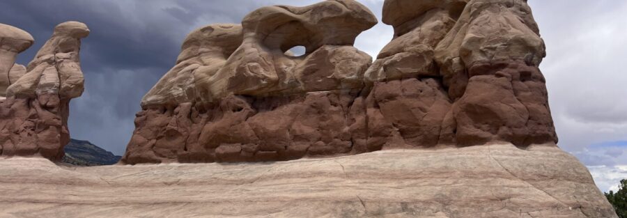
Devil’s Garden is a concentrated cluster of geological oddities that formed as softer surrounding sandstone eroded away and left harder rock standing. The result is hoodoos, arches, fins, and balanced rocks in configurations that look structurally improbable in person.
Metate Arch is the headline feature. A delicate natural arch spanning a fin of sandstone, it’s visible from the parking area and photographs well from multiple angles. The arch is more fragile than it looks and the BLM asks that visitors not climb on or touch it. Photograph from below and leave the structural integrity to geology.
The balanced rocks scattered through the area are the other visual standout. Boulders of harder caprock sitting on narrow sandstone pedestals, held up by differential erosion and whatever structural relationship keeps them from falling. They look temporary. They’ve probably been there for thousands of years.
The colors shift throughout the day. Morning light hits the eastern faces warm and the shadows are long. Midday goes high contrast and the colors mute slightly. Late afternoon turns the whole field amber. Any of these conditions work for photography. They just work differently.
There’s no defined trail at Devil’s Garden. You wander among the formations on sandy paths worn in by foot traffic, choosing your own route between features. The area is small enough that you naturally circle back to the parking area without needing to navigate. This is a place where getting temporarily turned around is part of the experience and never a real problem.
Most visitors spend 45 minutes to an hour here. Photographers and people who slow down and look at the rock detail can easily fill two hours. There’s no pressure either direction. The formations aren’t going anywhere.
The sandy terrain is level and accessible. Kids handle it without difficulty. Dogs handle it well. People who struggle with uneven surfaces or long distances handle it fine. This is one of the most accessible geology stops in all of Grand Staircase-Escalante.
Devil’s Garden photographs best in the first and last two hours of daylight. The morning light from the east hits the western faces of the formations and creates long warm shadows that emphasize the shapes. Evening light reverses the angle and turns the sandstone deeply saturated.
Midday light is workable but harsh. The red rock goes flat in overhead sun and the shadows disappear. If midday is your only option, overcast conditions actually work better than direct sun for the formation photography here.
For Metate Arch specifically, morning light coming through the arch from the east creates a backlit silhouette effect that’s one of the stronger compositional options on site. Position yourself west of the arch before the sun climbs too high.

Trail Difficulty and Length
Devil’s Garden covers 0.4 miles of open exploration with 36 feet of elevation gain. It’s genuinely easy. The terrain is flat sandy desert with minor undulation between formations. No scrambling, no route-finding challenge, no technical terrain.
This is a sightseeing stop and a photography location as much as it is a hike. Call it whatever feels accurate. The experience is real regardless of the label.
The main variable is heat. The site is fully exposed with limited shade. In summer, the open desert here gets hot fast. Go early, go late, or skip summer entirely.
Dog Friendly?
Yes. Devil’s Garden is one of the better dog stops in the GSENM corridor. The terrain is flat, sandy, and easy on paws. The open layout gives dogs room to move. The rock formations provide patches of shade.
Keep your dog on leash. BLM requires it throughout the monument. Bring water, the site has none. In summer, check the ground temperature before walking your dog across exposed sandy sections, desert sand heats fast and holds it.

What to Bring
Devil’s Garden is a short stop but it’s 12 miles from services on a dirt road in the desert. Treat it accordingly.
Water for the full visit plus the drive back. Carry more than you think you need.
Sun protection for the exposed site. Sunscreen, hat, and sunglasses from the moment you step out of the car.
For photography: a wide-angle lens for the formation clusters and arch compositions, a mid-range zoom for isolating balanced rocks against the sky. A polarizing filter cuts the desert glare and deepens the blue sky. Golden hour here doesn’t require a tripod, but one helps for the arch shots in lower light.
Closed-toe shoes. The sandy terrain is soft but rock edges appear unexpectedly when you’re moving among the formations.
Best Time to Visit Devil’s Garden
Spring (April through early June) and fall (September through October) are the best seasons. Mild temperatures, manageable crowds, and the light quality in the canyon country is at its best.
Summer is the one season to approach carefully. The exposed desert at Devil’s Garden traps heat and the 12-mile dirt road approach adds time in a vehicle without shade. Go very early in the morning or in the evening, and don’t linger at midday.
Winter is quiet and cold. The road stays passable in dry conditions but snow or ice on Hole-in-the-Rock Road can make it dangerous. The formations dusted with snow against a clear blue sky are genuinely striking if you hit the right conditions.
For photography, the golden hour windows on either end of the day are the primary targets. If you’re planning Hole-in-the-Rock Road for a full day with multiple stops, position Devil’s Garden as either your morning opener or your late afternoon closer.
Rules and Regulations
Devil’s Garden is part of Grand Staircase-Escalante National Monument, managed by the BLM.
Do not climb on, touch, or lean against the rock formations. The hoodoos, balanced rocks, and arches are fragile geological features. Metate Arch in particular is a delicate structure. Respect it from a distance.
Leave No Trace throughout. Pack out all trash. No facilities on site.
Stay off the cryptobiotic soil crust surrounding the sandy paths. The dark, bumpy biological crust visible between rock formations is a living layer that takes decades to recover from a single footstep. Walk on sand or rock only.
Dogs on leash at all times. No drones without a BLM permit. No fires at the site.
Where to Stay Near Devil’s Garden
Escalante is the closest base, 12 miles north on Hole-in-the-Rock Road plus the 5-mile drive back to town on Highway 12. Small motels and vacation rentals are available. Book ahead for spring and fall weekends, the town is small and fills fast during peak season.
For loyalty program accommodations, Boulder is 26 miles northeast on Highway 12 with the Boulder Mountain Lodge and access to Marriott Bonvoy properties in the broader region. Hilton Honors and IHG Rewards cover options in Bryce Canyon City and Panguitch, both within 45 to 60 miles northwest.
Camping Nearby
Dispersed camping is allowed on BLM land throughout the GSENM corridor along Hole-in-the-Rock Road. Pullouts near the formations or further south toward the monument’s interior work for vehicle-based camping at no cost. No permit required, Leave No Trace required. Check fire restrictions before any campfire.
Escalante Petrified Forest State Park, just outside Escalante on Highway 12, has a developed campground with hookup and non-hookup sites. Reserve through Utah State Parks. A clean, well-positioned base for multiple monument day trips.
Calf Creek Recreation Area on Highway 12, about 16 miles northeast toward Boulder, has BLM sites near the Lower Calf Creek Falls trailhead. First-come, first-served and popular on weekends.
Nearby Adventures
Devil’s Garden is a natural anchor for a full Hole-in-the-Rock Road day. Continue south from here and the road opens up more options.
The Dry Fork Narrows, Peekaboo, and Spooky Slot Canyons loop is about 14 miles further south on Hole-in-the-Rock Road. The best slot canyon loop in the monument and the obvious companion to a Devil’s Garden morning stop. Six miles, hard-rated, completely different experience than the formations here.
Zebra and Tunnel Slot Canyons are also off Hole-in-the-Rock Road, about 8 miles past the Devil’s Garden turnoff. Zebra in particular has some of the most striking striped sandstone walls in the entire monument.
The Escalante Natural Bridge is a short, easy hike right out of Escalante town. A natural arch spanning the Escalante River, accessible in under two miles. Good warm-up or wind-down hike on the same day as a Hole-in-the-Rock Road run.
The Burr Trail starts in Boulder, 26 miles northeast, and heads east through Long Canyon and the Waterpocket Fold switchbacks into Capitol Reef. One of the best drives in southern Utah and a natural extension of any multi-day Escalante itinerary.
The Anasazi State Park Museum in Boulder houses one of the largest collections of Ancestral Puebloan artifacts in the country. Free with a Utah State Parks pass and worth a stop before or after driving Highway 12.
AllTrails has Devil’s Garden mapped with user-reported conditions and an offline map download. Given zero cell service on Hole-in-the-Rock Road, download the map before you leave Escalante. The site is simple enough to navigate without it, but the offline map gives you context for the full road corridor if you’re continuing south.
Chase the Quiet
There’s something about standing among formations that have been sitting in the same place for millions of years, in configurations that look accidental but aren’t, in a desert that’s been here far longer than anything I’ll ever be part of. Devil’s Garden is a small place with a long timeline. That contrast does something useful to your sense of proportion. It’s one of the more efficient resets I know.
Support the Adventure
To make your walls less boring, check out my photography portfolio and bring a piece of the wild and my story into your home.
If you’d like to fuel future adventures, you can donate a coffee on Ko-Fi. Every cup keeps me chasing sunrises and stories.
When you shop using my affiliate links, every click helps support this blog at no extra cost to you. It’s a small way to keep Unicorn Adventure alive and kicking while I keep exploring.
Subscribe to my mailing list for future updates, new stories, and behind-the-scenes adventures.
Stay connected with me on Instagram and Facebook for more photos and daily inspiration.
Thanks for being part of the journey, Unicorn Squadron!

Theo Maynard is a landscape photographer and adventure blogger based in Salt Lake City. He chases remote desert and mountain light across the American West, documents it all solo, and shares the journey through Unicorn Adventure. He’s on the autism spectrum, and that’s not a footnote, it’s the whole story. He creates to inspire others to get outside, chase what lights them up, and live their best possible life. Unapologetically himself.