Most arches in Utah sit up on a ridge or perched above a canyon rim. Escalante Natural Bridge spans a river. That detail changes everything about the experience.
The bridge is a massive sandstone arch that crosses the Escalante River inside Grand Staircase-Escalante National Monument, about 14 miles east of the town of Escalante on Highway 12. The trail follows the river through a narrow canyon lined with red walls and cottonwood trees, and you’re in and out in 4.4 miles. It’s one of the more accessible hikes in the monument and one of the more visually striking.
Quick Facts
| Trail Name | Escalante Natural Bridge |
| Location | Grand Staircase-Escalante NM, near Escalante, Utah |
| Coordinates | 37.7760° N, 111.4196° W |
| Distance | 4.4 miles (round trip) |
| Elevation Gain | 291 feet |
| Difficulty | Easy to Moderate |
| Time | 2-3 hours |
| Dogs Allowed | Yes (on leash) |
| Fee | None |
| AllTrails | View on Alltrails |
How to Get There
From Escalante, head east on Highway 12 for 14 miles. The Escalante River Trailhead is well-signed directly off the highway. Coming from Boulder to the east, drive west on Highway 12 for about 11 miles. The pullout is on the south side of the road where the highway bridge crosses the Escalante River. You can’t miss it if you’re watching for it.
Parking Information
The parking area is an unpaved lot at the Escalante River Trailhead, right off Highway 12. It holds a decent number of vehicles but fills fast during spring and fall peak season. Arrive before 8 a.m. on weekends and you’ll be fine. No restrooms at the trailhead. Handle that in Escalante before you drive out.
Cell Service and Navigation
Cell service fades out well before you reach the trailhead and disappears completely in the canyon. Download your trail map offline through AllTrails or Gaia GPS before leaving Escalante. The route follows the river and is generally straightforward, but river crossings and canyon junctions can disorient you without a reference. Flash flood risk is real in this canyon. Check weather for the entire watershed, not just the immediate area, before heading in.
What to Expect on Escalante Natural Bridge
The Trail
The trail starts at the highway bridge and drops into the canyon immediately. From there it follows the Escalante River, weaving between the water and the canyon walls. Cottonwoods and willows crowd the riverbanks. The sandstone walls rise on both sides, banded in red and orange. The contrast between the green riparian vegetation and the bare red rock is genuinely striking, especially early in the morning when the light hits the upper walls and the canyon floor is still in shadow. Expect multiple river crossings. Bring shoes you don’t mind getting wet, or plan to take them off and wade.
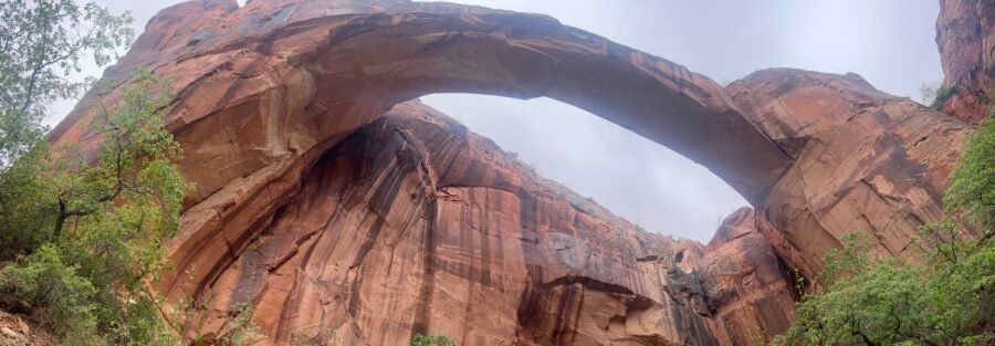
The bridge appears at around 2 miles in. It’s a wide, low sandstone arch spanning the river, with the canyon walls rising behind it. Unlike the elevated arches at places like Arches National Park, this one is at river level, which means you walk under it and look up through it. The scale registers differently when you’re standing inside it instead of photographing it from across a valley. It’s worth taking the extra minutes to explore the base before heading back.
Keep an eye on the canyon walls along the way. Ancient petroglyphs appear in several spots, subtle enough to miss if you’re moving fast. Slow down and scan the rock faces as you hike.
Trail Difficulty and Length
Escalante Natural Bridge is 4.4 miles round trip with 291 feet of elevation gain. It’s rated easy to moderate. The terrain is mostly flat river corridor with minor undulation. The river crossings are the main variable. In spring runoff the water can be knee deep or higher. In late summer and fall it’s often ankle deep or less. Sandals or trail runners you’re willing to wet are the practical footwear choice. The trail is suitable for most fitness levels and families with older children. Budget 2 to 3 hours for a comfortable round trip with time at the bridge.

Dog Friendly?
Yes. Dogs are allowed on leash and most will enjoy the river access along the way. Help them navigate the crossings and watch the canyon walls for slippery sections near the water. Bring extra water because shade in the canyon is limited in midday. In summer heat, an early start protects both of you.
What to Bring
Water-resistant footwear or a dry pair of shoes for the approach and a pair you’ll sacrifice for the crossings. At least 2 liters of water per person. Sunscreen and a hat for the exposed sections. Snacks for the bridge. A camera with a wide-angle lens if you want to capture the arch in context. The canyon is narrow enough that a standard zoom won’t get the full span in frame. Trekking poles help with river crossings if you use them. A headlamp if you’re starting early in dim canyon light.

Best Time to Hike Escalante Natural Bridge
Spring (April through June) and fall (September through October) are the best windows. Temperatures are comfortable and the light in the canyon is excellent. Summer is hot and the midday sun turns the canyon into an oven. Start before 7 a.m. if you’re hiking in summer. Winter is doable but river crossings can ice up in shaded sections and cold water crossings are unpleasant without preparation.
For photography, early morning is the best window. The canyon faces roughly east and west, so the warm light hits the upper walls at sunrise while the canyon floor stays shaded, which creates a dramatic contrast. The bridge itself photographs well from multiple angles. A wide lens and patience are your best tools. If you’re shooting the arch with the river in the foreground, a polarizing filter cuts the glare off the water.

Rules and Regulations
Escalante Natural Bridge falls under BLM management as part of Grand Staircase-Escalante National Monument. No permit is required and there’s no day-use fee. Leave No Trace applies fully: pack out everything, stay out of the river when flash flood watches are in effect, don’t touch or damage petroglyphs, and keep dogs leashed. Check current conditions with the Escalante Interagency Visitor Center before heading out, particularly in spring when runoff can raise river levels significantly.
Where to Stay Near Escalante
Escalante has solid in-town options including Entrada Escalante Lodge and Canyon Country Lodge.
Camping Nearby
The Calf Creek Recreation Area campground, about 1 mile east on Highway 12 from the Escalante River Trailhead, is a small reservable site right at the Lower Calf Creek Falls trailhead. It fills fast. Reserve through Recreation.gov.
Dispersed BLM camping is available throughout the monument. Cedar Point, South Turkey, and Spencer Flat are all within the Grand Staircase area. No hookups, no reservations, exceptional sky. The Escalante River corridor itself has established dispersed sites used by multi-day river canyon hikers.
Nearby Adventures
The Escalante River Trail continues well beyond the natural bridge if you want to push further into the canyon system. Stevens Arch and additional rock art panels are deeper in, accessible to hikers willing to commit to a multi-day route or longer day hike.
For other day hikes in the area, Lower Calf Creek Falls is 6.1 miles with 531 feet of gain and ends at a 126-foot waterfall about 1 mile further east on the highway. Zebra and Tunnel Slot Canyons cover 6.6 miles through some of the most striking slot terrain in the monument. The Cosmic Ashtray via Volcano Trail is 7.6 miles of trackless slickrock out to one of the strangest rock formations in southern Utah.
For scenic drives, Moki Dugway is a short drive south and one of the most dramatic roads in Utah. The Burr Trail runs east from Boulder and delivers big canyon views without leaving the pavement for much of the route.
In town, the Anasazi State Park Museum in Boulder covers Ancestral Puebloan history with real artifacts and a reconstructed village. The Escalante Petrified Forest State Park has fossilized wood and an easy loop trail that works well as a rest-day stop.
Plan This Hike
AllTrails has the Escalante Natural Bridge trail with a downloadable map, recent user conditions, and notes on river crossing depth from current hikers. Checking recent reports before you go gives you a realistic picture of what the crossings look like, which matters in spring especially.
AllTrails Pro is worth it for canyon country trips where signal disappears and offline navigation matters. Download the map before you leave Escalante.
Chase the Quiet
The Escalante River moves slow through this canyon. The walls press in close. There’s a version of quiet down here that’s different from mountain quiet or desert flat quiet. It’s contained. The canyon holds it. You walk through it for two miles and then an arch spans the river in front of you, sandstone shaped by water over millions of years into something that looks intentional. It isn’t. That’s the part that gets me every time.
Support the Adventure
To make your walls less boring, check out my photography portfolio and bring a piece of the wild and my story into your home.
If you’d like to fuel future adventures, you can donate a coffee on Ko-Fi. Every cup keeps me chasing sunrises and stories.
When you shop using my affiliate links, every click helps support this blog at no extra cost to you. It’s a small way to keep Unicorn Adventure alive and kicking while I keep exploring.
Subscribe to my mailing list for future updates, new stories, and behind-the-scenes adventures.
Stay connected with me on Instagram and Facebook for more photos and daily inspiration.
Thanks for being part of the journey, Unicorn Squadron!

Theo Maynard is a landscape photographer and adventure blogger based in Salt Lake City. He chases remote desert and mountain light across the American West, documents it all solo, and shares the journey through Unicorn Adventure. He’s on the autism spectrum, and that’s not a footnote, it’s the whole story. He creates to inspire others to get outside, chase what lights them up, and live their best possible life. Unapologetically himself.