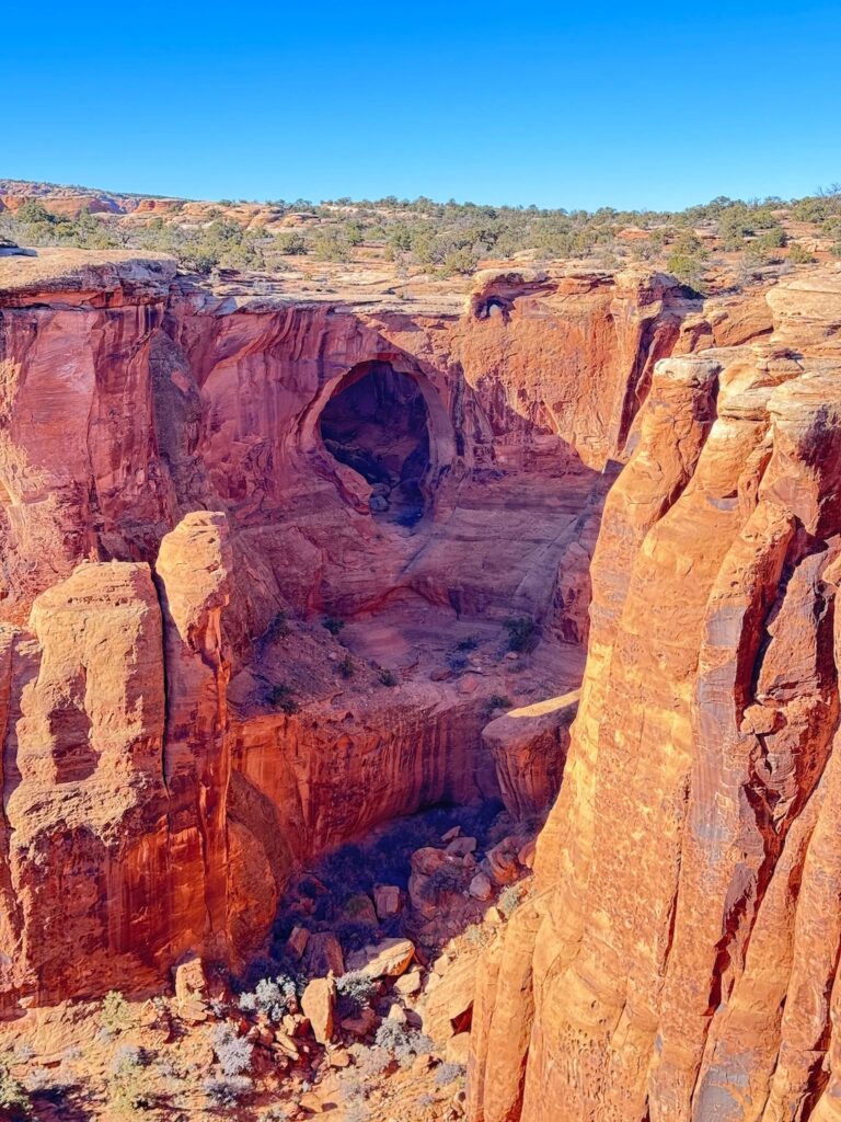
Two massive sandstone arches, side by side, suspended over a canyon drop with nothing but desert and red rock in every direction. That’s Gemini Bridges. It’s the payoff at the end of a 13-mile BLM off-road route that starts just north of Moab and works its way through the kind of terrain that makes you understand why people move their lives here to drive it on weekends.
The route is one of the more accessible OHV routes in the Moab area, manageable for high-clearance 4WD drivers without serious off-road experience, and the bridges themselves are a destination worth every mile of dirt road. Standing at the edge of Gemini Bridges looking down through two arches at the canyon below delivers a sense of scale that doesn’t need explanation.
This guide covers the Gemini Bridges OHV route from trailhead to arches: what you need to drive it, what the terrain is actually like, and how to build a full Moab day around it.
Quick Facts
|
Route Name |
Gemini Bridges OHV Trail |
|
Location |
BLM Land, near Moab, Utah |
|
Coordinates |
|
|
Distance |
Approx. 13 miles one-way (typically run as shuttle) |
|
Elevation Gain |
Approx. 1,900 feet |
|
Difficulty |
Moderate (high-clearance 4WD recommended) |
|
Time |
3-5 hours |
|
Dogs Allowed |
Yes, on leash |
|
Fee |
None (BLM land) |
|
AllTrails |
How to Get There
From Moab, head north on US-191 for about 6 miles, then turn left onto UT-313. Half a mile down UT-313 on the left, you’ll see the signed Gemini Bridges Road, a dirt road that begins the route. This is the top trailhead if you’re running the route top-to-bottom as most people do.
The route runs approximately 13 miles one-way and ends near the day-use area at the base of the cliffs on the Moab side. Running it top-to-bottom requires a two-vehicle shuttle or leaving a vehicle at the lower end before driving to the upper trailhead. Alternatively, some drivers run it out-and-back to the bridges themselves, roughly 5-6 miles each way from the top, and return the same way. That’s a longer day but skips the shuttle logistics.
From Salt Lake City, plan about 4 hours to Moab: I-15 south, US-6 east, US-191 south. From Grand Junction, Colorado, roughly an hour west. No entry fee, no reservation required. BLM land. You just show up and drive.
Cell Service and Navigation
Cell coverage is unreliable on Gemini Bridges Road once you’re past the UT-313 turnoff. Download AllTrails or a dedicated OHV navigation app offline before leaving Moab. The route is generally well-tracked and follows established two-track, but having GPS is useful in a few spots where the road forks.
A paper map of the BLM Moab area trails is worth having in the glove box as backup. The Moab BLM Field Office has current maps and can provide route conditions information before you head out. Their office is in Moab and worth a 10-minute stop if you’re unsure about current conditions.
What to Expect on the Gemini Bridges OHV Trail
The Road
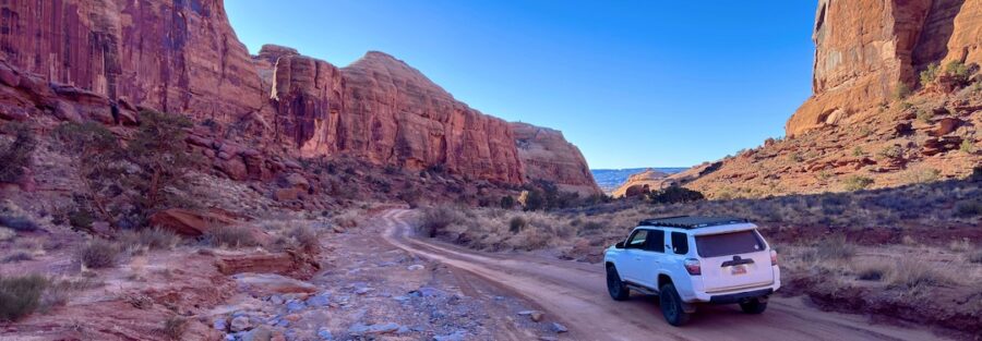
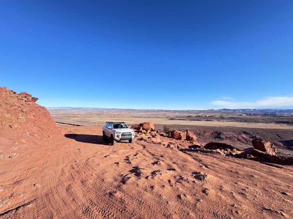
The route starts on Gemini Bridges Road off UT-313 and descends through open mesa terrain before dropping into canyon country. The first several miles are relatively mellow, rough two-track across slickrock and dirt with good visibility and no significant obstacles. It’s the kind of driving that builds confidence early before the terrain asks more of you.
The middle section has rockier terrain, some embedded sandstone steps, and a few spots where you pick a line across exposed rock rather than following a defined track. Nothing extreme, but it requires engagement and a bit of route-reading. Airing down to 20-25 PSI before you start improves traction significantly on the rocky sections and the sandy stretches you’ll encounter lower down.
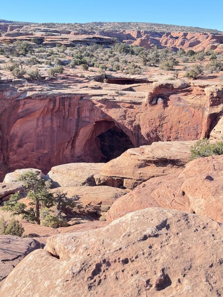
The approach to Gemini Bridges involves a short parking area near the arch viewpoint. From there, a brief walk puts you at the edge of the canyon and at the arches themselves.
The Bridges
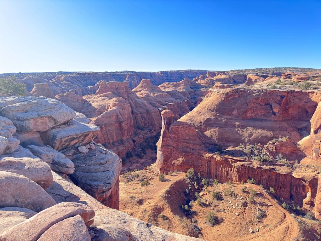
Gemini Bridges are two parallel sandstone arches spanning a canyon side by side, each roughly 100 feet wide. They’re not freestanding in the classic arch sense but span as natural bridges carved by erosion into the canyon wall. Standing between them or at the edge looking down through both openings at the canyon below is one of the better arch experiences in the Moab area precisely because you earn it with miles of road rather than a short parking lot walk.
The canyon drop below is significant. Stay back from the edge. The rock at the lip is solid but the drop is real and the exposure warrants respect. For photography, a wide-angle lens captures both bridges together and the canyon below. Early morning or late afternoon light comes from the east and west respectively and does interesting things with the arch geometry and the red rock walls.
Drive Difficulty and Length
Moderate is more accurate and more honest for drivers new to 4WD terrain. The 13-mile one-way route has about 1,900 feet of elevation change and covers terrain that ranges from mellow dirt road to rocky two-track requiring real attention. High-clearance 4WD is recommended, not just preferred. A stock lifted SUV with real 4WD handles it fine. A crossover with AWD and low clearance is going to have a bad day on the rockier sections.
Plan 3-5 hours for the full one-way route including time at the bridges. Out-and-back to the bridges and back doubles that. If you’re running a shuttle, add drive time to position the second vehicle at the lower trailhead before starting.
Dog Friendly?
Yes. Gemini Bridges is BLM land, so dogs are welcome. Keep them leashed and bring plenty of water. The desert heat affects dogs faster than most owners expect, especially on exposed rock surfaces that radiate heat from below. Plan shade breaks and carry at least 1 liter of water per dog per hour of activity in warm conditions.
The short walk from the parking area to the arch viewpoint is easy terrain for dogs. The canyon edge requires the same caution for dogs that it requires for people: keep them back from the drop and leashed near the rim.
What to Bring
For the vehicle: a recovery kit. On a route like this, that means a tow strap, a shovel, and a portable air compressor to re-inflate after airing down. Carrying a hi-lift jack adds useful recovery options if you get stuck on a rocky section. A full-size spare is non-negotiable on any Moab OHV route.
For you and passengers: water, minimum 2-3 liters per person. Sun protection, hat, sunscreen, sunglasses. The route is exposed for most of its length. Snacks with salt content to replace electrolytes on hot days. Sturdy shoes for the walk to the arch viewpoint.
For communication: a satellite communicator like a Garmin inReach is worth carrying on any remote BLM route where cell service is absent. If something goes mechanically wrong out there, that device is your link to help.
Camera gear: wide-angle lens for the arch span, longer focal length for canyon detail. The bridges photograph best from directly between them looking along their span, and from the canyon edge looking through both openings at once.
Best Time to Drive Gemini Bridges
Spring (March through May) and fall (September through November) are the sweet spots. Temperatures are manageable, the desert light is warm, and the roads are dry. Spring in particular brings occasional desert wildflowers to the mesa sections of the route.
Summer driving is doable with an early start, before 7 a.m., and a commitment to being back at the vehicle or at a shaded spot by midday. The exposed mesa terrain heats up fast in July and August and dehydration risk is real. Carry twice the water you think you need.
Winter brings cold temperatures and the possibility of snow or ice on the upper sections of the route near UT-313. Check conditions before committing. Snow on BLM dirt roads in this area can create mud that gets axle-deep in spots. Rain has the same effect. If there’s been recent precipitation, wait a day.
For photography at the bridges, early morning is the best window. The eastern light angles into the arches from behind you as you approach from the upper trailhead, and the canyon below is partially in shadow, which adds depth. Late afternoon from the lower approach works well if you’re running bottom-to-top.
Rules and Regulations
Stay on designated roads and tracks. BLM land in the Moab area is covered with cryptobiotic soil crust that takes decades to recover from tire tracks off established routes. Do not create new tracks, do not drive around obstacles onto virgin desert surface.
Pack out all trash. Dogs must be leashed. No fires without a fire pan in most BLM areas around Moab. Check current fire restrictions with the Moab BLM Field Office before your trip, as restrictions change seasonally and with drought conditions.
Flash flood risk is real in canyon country. Check the forecast for the entire upstream watershed, not just Moab, before driving routes that pass through washes or canyon bottoms. A storm 50 miles away can flood a wash you’re driving through. No entry fee, no permit required for this route.
Where to Stay Near Moab
Moab is the base. The town has lodging at every price point and sits just 6 miles from the upper Gemini Bridges trailhead on UT-313. Red Cliffs Lodge on the Colorado River and The Caves at Moab are both options with character beyond a standard chain room. For points travelers, check Marriott Bonvoy properties in Moab, IHG Rewards hotels near Moab, and Hilton Honors options in the area. Spring and fall availability disappears fast in Moab. Book early.
Camping Nearby
Gemini Bridges is also a dispersed camping destination. The BLM allows camping along the route at established spots, and the mesa terrain above the bridges makes for a memorable overland camp with open sky and no facilities except what you bring. Standard BLM rules apply: pack in, pack out, 14-day stay limit, no fires without a fire pan and current restrictions allowing.
The Sandflats Recreation Area east of Moab has both dispersed and fee sites with facilities and is the most organized camping option for OHV-based Moab trips. Porcupine Rim and the Gemini Bridges area itself are the two most popular dispersed spots for overlanders using Moab as a base.
Nearby Adventures
Long Canyon OHV Route is the natural companion run, running roughly parallel to Gemini Bridges in the same general BLM area northwest of Moab. A different character of terrain with more confined canyon driving, it pairs well as a second-day route if you’re spending multiple days in the area.
For hikers in your group who aren’t driving, Corona Arch Trail is 10 miles south on Potash Road and runs about 3 miles roundtrip with dogs allowed. It’s a natural split-day option if you have mixed hikers and drivers.
Grandstaff Canyon Trail (formerly Negro Bill Canyon) is a 5.7-mile roundtrip hike to Morning Glory Bridge, a massive natural span, with 836 feet of gain. It’s one of the better hikes in the Moab area and accessible without a national park fee.
Inside Arches National Park, Delicate Arch and the Windows Loop are the obvious hiking additions to an OHV day. Dead Horse Point State Park is a quick 30-mile drive for the canyon overlook. Canyonlands Island in the Sky is a full separate day.
Plan This Drive
AllTrails has the Gemini Bridges OHV Trail mapped with GPS tracking and offline capability. Download it before leaving Moab. Plan your drive on AllTrails and pull the offline map while you’ve got signal in town.
Chase the Quiet
Two arches, side by side, suspended over a canyon. You drive 13 miles of BLM dirt road to get there. That’s the trade, and it’s a good one. The bridges don’t get fewer visitors because they’re less impressive than the famous arches in the national park 30 miles east. They get fewer visitors because they require a truck and a willingness to drive a dirt road for a few hours. That’s the entire moat. Cross it once and the math becomes obvious.
Support the Adventure
To make your walls less boring, check out my photography portfolio and bring a piece of the wild and my story into your home.
If you’d like to fuel future adventures, you can donate a coffee on Ko-Fi. Every cup keeps me chasing sunrises and stories.
When you shop using my affiliate links, every click helps support this blog at no extra cost to you. It’s a small way to keep Unicorn Adventure alive and kicking while I keep exploring.
Subscribe to my mailing list for future updates, new stories, and behind-the-scenes adventures.
Stay connected with me on Instagram and Facebook for more photos and daily inspiration.
Thanks for being part of the journey, Unicorn Squadron!

Theo Maynard is a landscape photographer and adventure blogger based in Salt Lake City. He chases remote desert and mountain light across the American West, documents it all solo, and shares the journey through Unicorn Adventure. He’s on the autism spectrum, and that’s not a footnote, it’s the whole story. He creates to inspire others to get outside, chase what lights them up, and live their best possible life. Unapologetically himself.