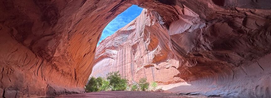
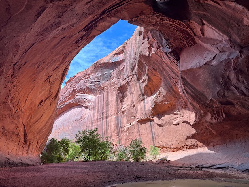
Three holes punched through the ceiling of a red rock canyon, sunlight pouring through each one onto a pool of water below. That’s the Golden Cathedral. No photograph does it right.
The Golden Cathedral sits at the end of Neon Canyon inside Glen Canyon National Recreation Area, accessible from the Egypt Trailhead off Hole-in-the-Rock Road east of Escalante. The route is 9.1 miles round trip with 1,581 feet of gain across slickrock, sandy washes, river crossings, and a canyon descent that earns every step.
Quick Facts
| Trail Name | The Golden Cathedral Trail (Neon Canyon) |
| Location | Glen Canyon National Recreation Area, near Escalante, Utah |
| Coordinates | 37.5933° N, 111.2177° W |
| Distance | 9.1 miles (round trip) |
| Elevation Gain | 1,581 feet |
| Difficulty | Moderate to Difficult |
| Time | 5-8 hours |
| Dogs Allowed | Yes (on leash, with preparation) |
| AllTrails | View on Alltrails |
How to Get There
From Escalante, head east on Highway 12 for about 5 miles and turn south onto Hole-in-the-Rock Road. Drive approximately 16 miles down the dirt road, then turn east onto Egypt Road. Follow Egypt Road to the Egypt Trailhead. Egypt Road is rougher and rockier than Hole-in-the-Rock Road and requires a high-clearance vehicle. Four-wheel drive is the smart choice, not a suggestion. The road becomes impassable in wet conditions. Allow 45 to 60 minutes just for the drive from Highway 12.
Download your navigation before you leave Escalante. Signage is minimal out here and the open landscape offers a lot of opportunities to go the wrong direction. GPS coordinates for the trailhead: 37.5933, -111.2177.
Parking Information
Egypt Trailhead is a large dirt area with room for multiple vehicles. No fee, no facilities, no water. Bring everything you need from Escalante. Lock your vehicle and stash valuables out of sight. This is a remote location with no services nearby. Start early to preserve daylight for the full 9.1-mile round trip.
Cell Service and Navigation
No cell service at the trailhead or on trail. Signal disappears well before you reach Egypt Road. Download AllTrails or Gaia GPS maps offline before leaving Escalante. Navigation between Egypt Trailhead and Neon Canyon requires route-finding across open slickrock and through washes. A GPS track is not optional here. Getting off route adds miles and burns time you need for a full-day hike. Flash flood risk in Neon Canyon is serious. Check weather for the entire regional watershed before driving out, not just the local forecast.
What to Expect on the Golden Cathedral Trail
The Approach
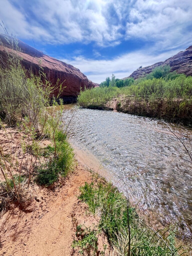
The trail starts at Egypt Trailhead and crosses open slickrock and sandy washes toward the canyon system. The landscape is vast and initially flat, which can make distances feel deceptive. Cairns mark the route in spots but are inconsistently placed. You’ll cross the Escalante River multiple times depending on the season. Water levels vary significantly from spring runoff to late summer low. Check recent reports before going. Bring shoes you can get wet or a dry pair for the approach and sacrificial footwear for the crossings.
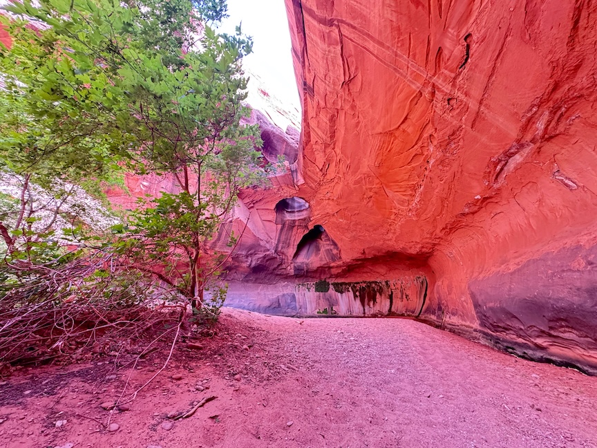
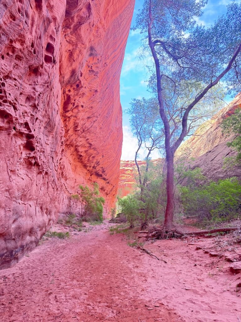
The descent into Neon Canyon is where the hike earns its reputation. The first section drops steeply, and the canyon walls rise fast as you go deeper. The canyon is narrow, the rock glows in a warm amber light that gives it its name, and the silence is absolute. This is one of the most beautiful canyon environments in southern Utah and it sees a fraction of the traffic that Zion or Bryce absorbs. Take your time in here.
The cathedral appears at the end of the canyon. Three large potholes are carved through the ceiling of the rock, and when sunlight hits them it beams down in columns onto the pool below. The effect is genuinely otherworldly. Mid-morning in spring or fall is the best window to catch the light at the right angle. The pool at the base is cold and clear. Sit here. Eat your lunch. You hiked 4.5 miles with 1,500-plus feet of gain to get here. Give it the time it deserves before turning around.
Trail Difficulty and Length
The Golden Cathedral Trail is 9.1 miles round trip with 1,581 feet of elevation gain. It’s rated moderate to difficult, and that rating is honest. The combination of distance, elevation, route-finding, river crossings, and a steep canyon descent makes this a full-day commitment. Budget 5 to 8 hours depending on pace and how long you spend at the cathedral. The descent into Neon Canyon is steep enough to demand careful footing. The climb back out is harder than the descent because fatigue compounds. Don’t underestimate it. This is not a casual hike for unprepared hikers, and it’s not a trail to improvise.
Dog Friendly?
Yes, dogs are allowed on leash. This hike has enough rough slickrock, river crossings, and heat exposure to make it genuinely challenging for dogs. If your dog is trail-hardened, fit, and good in water, it’s manageable with preparation. Bring significantly more water than you think they need, check paws on the hot rock, and consider the temperature before committing. A dog struggling on the climb out of Neon Canyon with miles still to go is a problem. Know your dog.
What to Bring
This is a full-day desert backcountry hike. Water is the priority: at least 3 to 4 liters per person. There’s no reliable water source on trail without a filter, and the river crossings are not a drinking water solution without treatment. Sun protection head to toe for the exposed approach. Water-resistant footwear or a wet pair for crossings and a dry pair for the slickrock. Trekking poles make the canyon descent and ascent significantly more manageable. A headlamp in case you run long. Lunch and snacks because you need fuel for the return. A wide-angle lens and tripod if photography is the point, which it probably is.

Best Time to Hike the Golden Cathedral
Spring (March through May) and fall (late September through early November) are the best windows by a significant margin. Cooler temperatures make the distance and elevation manageable, the river crossings are more predictable, and the light in Neon Canyon is excellent. Summer brings brutal heat on the exposed approach and thunderstorm-driven flash flood risk in the canyon. An early start in summer is mandatory and even then it’s a hard day. Winter is possible in mild years but ice on the canyon descent and cold river crossings make it a serious undertaking.
For photography, aim for mid-morning arrival at the cathedral in spring or fall. The light cuts through the potholes in the ceiling at the most dramatic angle between roughly 9 and 11 a.m. depending on time of year. A wide-angle lens is essential to capture all three skylights in a single frame. The pool at the base reflects the light in ways that reward patience and a tripod.
Rules and Regulations
The Golden Cathedral sits inside Glen Canyon National Recreation Area, managed by the National Park Service. Day hiking requires no permit. Overnight trips in the backcountry require a free backcountry permit, available through the Escalante Interagency Visitor Center. Leave No Trace applies fully: pack out everything, don’t alter cairns, stay out of the canyon during flood watches, and treat the pothole pools with care. Potholes are microhabitats and wading or swimming in them causes real ecological damage. Photograph them, don’t wade them. Check current conditions before driving out, including road conditions on Egypt Road.
Where to Stay Near Escalante
Escalante is the base for the Golden Cathedral. Entrada Escalante Lodge and Canyon Country Lodge are solid in-town options. For hotel points and broader availability, Panguitch and Bryce Canyon City are about an hour northwest.
Camping Nearby
Dispersed camping on BLM and NPS land along Hole-in-the-Rock Road puts you closest to the Egypt Trailhead. Cedar Point, South Turkey, and Spencer Flat are all in the broader Escalante area. No hookups, no reservations, exceptional sky. If you’re committing to a full day at the Golden Cathedral, camping close to the trailhead and starting at first light is the smart play.
The Calf Creek Recreation Area campground on Highway 12 is a reservable option with restrooms closer to town, right at the Lower Calf Creek Falls trailhead. Book through Recreation.gov.
Nearby Adventures
The Golden Cathedral pairs well with other Hole-in-the-Rock Road destinations. Zebra and Tunnel Slot Canyons (6.6 mi / 469 ft) are about 8 miles down the road from Highway 12. Dry Fork Narrows with Peekaboo and Spooky Slot Canyons (6.0 mi / 656 ft) are further down and offer some of the tightest slot canyon passages in the monument. Bighorn Canyon Trail (6.0 mi / 390 ft) is the deep-cut option for hikers who want genuine solitude even further down the road.
Back near the highway, Lower Calf Creek Falls (6.1 mi / 531 ft) and Upper Calf Creek Falls (2.0 mi / 557 ft) are solid rest-day hikes after a big day at the cathedral. Escalante Natural Bridge (4.4 mi / 291 ft) along the river is an easy add to any multi-day Escalante itinerary. The Cosmic Ashtray via Volcano Trail (7.6 mi / 810 ft) takes you east of town on Spencer Flat Road for open slickrock hiking to one of the strangest formations in southern Utah.
For scenic drives, Moki Dugway is a short drive south and one of the most dramatic roads in Utah. Highway 12 itself is one of the most scenic drives in the country and worth taking slow on the way in or out.
Off the trail, the Anasazi State Park Museum in Boulder covers Ancestral Puebloan history with real artifacts and a reconstructed village. The Escalante Petrified Forest State Park is a quick rest-day stop with fossilized wood and an easy interpretive loop.
Plan This Hike
AllTrails has the Golden Cathedral Trail with a downloadable map, recent user conditions, and notes on river crossing depth and route-finding from current hikers. Given the navigation demands and remote location, downloading the offline map before you lose signal is essential. Recent reports about water levels and Egypt Road conditions are genuinely useful for planning.
View on Alltrails.
AllTrails Pro is worth it for backcountry desert routes like this. Offline maps and GPS tracking on open slickrock without cell service is exactly what it was built for.
Chase the Quiet
Sunlight through three holes in the ceiling of a canyon onto a pool of water below. That’s the whole thing. You can describe it all you want but the only way to understand it is to hike 9.1 miles and stand inside it. The light moves. The silence is complete. The rock glows. Whatever was loud in my head before I walked into Neon Canyon went quiet in there and stayed quiet for a while after I walked out. That’s not nothing.
Support the Adventure
To make your walls less boring, check out my photography portfolio and bring a piece of the wild and my story into your home.
If you’d like to fuel future adventures, you can donate a coffee on Ko-Fi. Every cup keeps me chasing sunrises and stories.
When you shop using my affiliate links, every click helps support this blog at no extra cost to you. It’s a small way to keep Unicorn Adventure alive and kicking while I keep exploring.
Subscribe to my mailing list for future updates, new stories, and behind-the-scenes adventures.
Stay connected with me on Instagram and Facebook for more photos and daily inspiration.
Thanks for being part of the journey, Unicorn Squadron!

Theo Maynard is a landscape photographer and adventure blogger based in Salt Lake City. He chases remote desert and mountain light across the American West, documents it all solo, and shares the journey through Unicorn Adventure. He’s on the autism spectrum, and that’s not a footnote, it’s the whole story. He creates to inspire others to get outside, chase what lights them up, and live their best possible life. Unapologetically himself.