

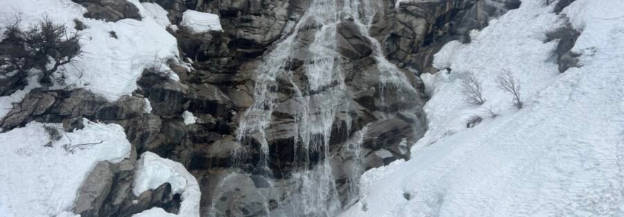
Horsetail Falls sits in Lone Peak Wilderness at the end of a 4.2-mile roundtrip with 1,600 feet of gain through Dry Creek Canyon near Alpine, Utah. The Dry Creek Trailhead at the end of Box Elder Canyon Road is the starting point, and the canyon it leads into is one of the better hard-day options on the Wasatch Front for hikers who want significant elevation and forest terrain without driving hours out of the Salt Lake Valley. Extensive Alpine/Lone Peak Wilderness routes share this corridor: Box Elder Peak (9.1 miles / 4,616 ft gain), Lone Peak via Peak View and Jacob’s Ladder (15.6 miles), and multiple others. Horsetail Falls is the accessible-to-most option in a collection that gets much harder from there. That framing matters: this is not an easy trail, but it’s the entry-level hard trail in a wilderness area that has routes requiring full-day commitments and serious technical fitness.
Quick Facts
| Trail Name | Horsetail Falls Trail via Dry Creek Canyon |
| Coordinates | 40.4829 N, 111.7504 W (Dry Creek Trailhead) |
| Distance | 4.2 miles roundtrip |
| Elevation Gain | ~1,600 feet |
| Difficulty | Hard |
| Time | 3-5 hours |
| Dogs Allowed | Yes, on leash |
| Fee | Free |
| View on AllTrails | |
How to Get There
From I-15, take Exit 284 (Timpanogos Highway/UT-92) and head east toward Highland and Alpine. After approximately 4 miles, turn left onto 5300 W/Alpine Highway and continue about 2 miles. At the roundabout, take the first exit onto Main Street, then follow Grove Drive east for about 1.5 miles until it becomes Box Elder Canyon Road. Continue on Box Elder Canyon Road to the Dry Creek Trailhead at the road’s end. From Salt Lake City, plan about 40-45 minutes via I-15 south and UT-92. From Provo, about 20-25 minutes north on I-15 and west on UT-92. The trailhead is at the edge of the Alpine residential area, and the final sections of Box Elder Canyon Road pass through neighborhoods. Drive carefully. The Lone Peak Wilderness is accessible year-round but the Horsetail Falls Trail can be snow-covered and icy from November through April. Microspikes or traction devices are useful for winter and early spring visits. The trail is most reliably clear from late May through October.
Parking Information
The Dry Creek Trailhead parking area at the end of Box Elder Canyon Road is the starting point for Horsetail Falls and several other Lone Peak Wilderness trails. It fills quickly on weekends from May through October, particularly on Saturday mornings. Arrive before 7:30 a.m. on peak weekends. No restrooms, no facilities, no fee. Roadside parking along Box Elder Canyon Road is available if the lot is full; park in designated areas only and respect residential access. 
Cell Service and Navigation
Cell coverage is reasonable at the trailhead and holds for the lower canyon sections. It drops as you gain elevation in the Wilderness. Download AllTrails offline before leaving Salt Lake Valley. The trail is well-marked on the lower sections where it follows Dry Creek; navigation becomes less obvious in the steeper upper sections approaching the falls. Having the GPS track active is useful for the upper half of the hike.
What to Expect on the Horsetail Falls Trail
Dry Creek Canyon
The trail from the Dry Creek Trailhead enters the canyon immediately and follows Dry Creek upstream through pine and aspen forest. The lower section of the trail is the most accessible: gentle grade, forest shade, the creek audible alongside the path. Wildflowers in May and June, aspen color in late September, the creek level varying from spring flood to summer trickle depending on the month. The trail is well-maintained on the lower portions and the footbridge crossings are established. The canyon walls rise above as you gain elevation, and the views of the ridgeline above open progressively as the forest thins.
The Upper Section and Falls Approach
The hard rating earns its label on the upper section. The trail steepens significantly and the terrain becomes rocky and loose in sections. The 1,600 feet of gain is not distributed evenly; a significant portion comes in the upper half of the hike. Trekking poles help on both the ascent and the return, particularly on the loose gravel sections. Horsetail Falls comes into view as the trail rounds the final canyon section. The water cascades down a sheer cliff face with the characteristic horsetail pattern: spreading as it falls rather than remaining a single stream. The rock at the base is wet and slippery from the constant mist. For photography: the falls catch morning light from the east. A wide-angle for the full cascade and the cliff face above, mid-range for the water and rock texture, a tripod for the slow shutter work to render the water as silky rather than frozen. The mist at the base can create lens issues; bring a dry cloth.
Trail Difficulty and Length
Hard is the accurate label: 1,600 feet of gain over 4.2 miles with steep, rocky upper sections earns the rating. Budget 3-5 hours for the roundtrip at a comfortable pace with time at the falls. The descent on the loose upper sections takes careful footwork and shouldn’t be rushed.
Dog Friendly?
Yes. Lone Peak Wilderness allows leashed dogs. The lower canyon section is comfortable for most trail-fit dogs. The rocky upper sections require dogs that are confident on uneven terrain with some steeper pitches. The creek access on the lower trail provides water throughout the approach. Bring additional water for dogs on the upper section where creek access ends.
What to Bring
Water: 2-3 liters for a hard 4.2-mile day. The creek provides natural water access on the lower section with treatment or filtration, but carry enough to reach the falls without depending on trail sources. Layers for the upper exposed sections where wind can be present. Sturdy trail runners or hiking boots with ankle support for the loose rocky upper terrain. Trekking poles: worth having for the steep upper section and the descent. Sun protection for the open upper sections above the forest canopy.
Best Time to Hike Horsetail Falls
Late May through October is the reliable window. The trail is snow-covered from approximately November through April; traction devices are necessary for winter visits if you attempt the upper sections. Late May and June are peak flow for the falls when snowmelt from the Lone Peak Wilderness above is active. Afternoon thunderstorms develop over the Wasatch Front in July and August. Start the hike by 7 a.m. and plan to be descending before noon on storm-likely days. The upper canyon has some exposure to lightning when weather develops overhead. September is the best overall month: clear mornings, cool temperatures ideal for sustained hard hiking effort, and aspen color in the lower canyon by mid-month. October is possible but traction conditions can develop on the upper rocky sections with early cold snaps.
Rules and Regulations
Lone Peak Wilderness rules apply. Stay on the designated trail to protect fragile alpine vegetation in the upper sections. No fires in the Wilderness. Pack out all trash. Leave No Trace principles throughout. No overnight camping without a permit at designated sites. Dogs on leash.
Where to Stay Near Alpine
Alpine and Highland are bedroom communities without significant hotel infrastructure. Lehi, 10 minutes south on I-15, has major chain hotels at freeway exits. Salt Lake City, 30-35 minutes north, is the full metro base. For points travelers, check available Marriott Bonvoy properties in Lehi, IHG Rewards hotels in Lehi, and Hilton Honors options in Lehi.
Camping Nearby
American Fork Canyon, accessible from UT-92 a short drive east, has developed campgrounds through recreation.gov. Timpanogos Cave National Monument area campgrounds are nearby. Lone Peak Wilderness dispersed camping requires a permit for overnight stays.
Nearby Adventures
Extensive Lone Peak Wilderness routes extend from the Alpine area. Box Elder Peak at 9.1 miles / 4,616 feet of gain is the serious summit option from the same corridor, a full hard day. Lone Peak via Peak View and Jacob’s Ladder at 15.6 miles is the major commitment peak in the area and one of the most respected hard hikes on the Wasatch Front. More accessible from the same trailhead: Dry Creek Canyon Trail is a companion route that shares the trailhead. For anyone building up to Horsetail Falls, the lower canyon sections offer an easier out-and-back without committing to the upper 1,600-foot push. Timpanogos Cave National Monument in American Fork Canyon is the non-hiking companion for the UT-92 corridor: a guided cave tour through a series of limestone formations. Worth combining with a Dry Creek Canyon day for families with varied ability levels.
Plan This Hike
AllTrails has Horsetail Falls mapped with offline GPS tracking and condition reports including current trail snow and upper section conditions. Plan your hike on AllTrails and download the offline map before you lose coverage in the upper canyon.
Chase the Quiet
The Lone Peak Wilderness starts right where Alpine ends. The trailhead is at the back of a residential street and the canyon begins immediately past it, which is one of the more abrupt transitions from suburb to genuine wilderness anywhere in the Wasatch Front. Dry Creek Canyon a mile in has no housing visible. Two miles in you’re in a landscape that reads as remote. That compression of suburban edge and mountain wilderness is one of the specific things that makes the Wasatch Front worth living near and worth getting into regularly.
Support the Adventure
To make your walls less boring, check out my photography portfolio and bring a piece of the wild and my story into your home. If you’d like to fuel future adventures, you can donate a coffee on Ko-Fi. Every cup keeps me chasing sunrises and stories. When you shop using my affiliate links, every click helps support this blog at no extra cost to you. It’s a small way to keep Unicorn Adventure alive and kicking while I keep exploring. Subscribe to my mailing list for future updates, new stories, and behind-the-scenes adventures. Stay connected with me on Instagram and Facebook for more photos and daily inspiration. Thanks for being part of the journey, Unicorn Squadron!

Theo Maynard is a landscape photographer and adventure blogger based in Salt Lake City. He chases remote desert and mountain light across the American West, documents it all solo, and shares the journey through Unicorn Adventure. He’s on the autism spectrum, and that’s not a footnote, it’s the whole story. He creates to inspire others to get outside, chase what lights them up, and live their best possible life. Unapologetically himself.