

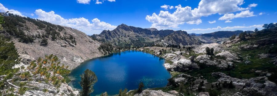
Nevada doesn’t look like this from the highway. Interstate 80 through Elko shows you high desert, basin and range, the kind of landscape that’s beautiful in a specific low-water way but doesn’t prepare you for what happens when you turn south on NV-227 and drive into Lamoille Canyon. The Ruby Mountains rise over 11,000 feet out of the Great Basin and they do it quickly. The canyon walls go vertical. Aspens line the creek. And at the end of the road, the Liberty Lake Trail climbs 1,500 feet to an alpine lake sitting in a granite bowl with no cell service and no crowds and the kind of quiet that takes about 20 minutes at the trailhead to fully believe. I drove Lamoille Canyon on a route that took me through Elko heading west, and this trailhead ended up being one of those detours that reorganizes the rest of the trip. I tend to notice when an environment shifts registers completely, and Lamoille Canyon does that relative to the Nevada everyone assumes they’re getting. Liberty Lake is 3 miles in and worth every one of them. This guide covers the Liberty Lake Trail: what the hike actually involves, how to get to a trailhead that requires some navigating, what to expect at the lake, and how to build a day around it from Elko.
Quick Facts
| Trail Name | Liberty Lake Trail |
| Location | Lamoille Canyon, Ruby Mountains, Elko, Nevada |
| Coordinates | 40.6043° N, 115.3755° W |
| Distance | 8.8 miles roundtrip |
| Elevation Gain | ~2,000 feet |
| Difficulty | Moderate |
| Time | 4–5 hours |
| Dogs Allowed | Yes, on leash |
| Fee | None (National Forest land) |
| AllTrails | View on AllTrails |
How to Get There
From Elko, head south on NV-227 for about 20 miles toward Lamoille. At Lamoille, turn right onto Lamoille Canyon Road (Forest Road 660). Follow Lamoille Canyon Road approximately 12 miles through the canyon to the large parking area at the end of the road. This is the trailhead for both the Liberty Lake Trail and the Island Lake Trail, which share the same starting point. The Lamoille Canyon Scenic Byway is worth driving slowly. The canyon walls rise dramatically as you gain elevation and the road passes multiple picnic areas, viewpoints, and short nature trails. Give yourself an extra 30 minutes on the drive in if you haven’t seen it before. From Salt Lake City, Elko is roughly 3 hours west on I-80. From Reno or the Bay Area, Elko is about 5-6 hours east on I-80. The trailhead is about 30 miles and 40 minutes from downtown Elko. No entry fee for Humboldt-Toiyabe National Forest. No permit required for day hiking. America the Beautiful Pass is not needed here but covers entry if you’re also hitting national parks on the same trip.
Parking Information
The parking area at the end of Lamoille Canyon Road is large and free. It fills up on summer weekends, particularly Saturday and Sunday mornings, when both the Liberty Lake and Island Lake trails draw crowds from Elko and the broader region. Arrive before 8 a.m. on weekends to secure a spot. Weekday mornings are significantly quieter. Restrooms are available at the trailhead. No water at the parking area itself, though the creek in the canyon and the lake at the end of the trail are water sources requiring treatment or filtration. Bring your own potable water from Elko. 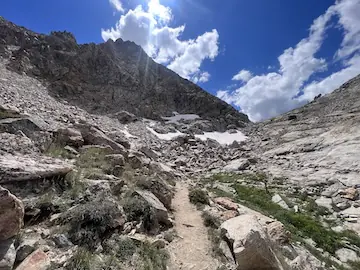
Cell Service and Navigation
Cell coverage drops off on NV-227 south of Elko and is largely absent in Lamoille Canyon and at the trailhead. Download AllTrails or another offline navigation app before leaving Elko. The trail is well-marked with signs and cairns at key junctions, but having the GPS map active is useful on the upper sections where the route crosses open rocky terrain near the lake. The Liberty Lake Trail shares its first section with the Island Lake Trail before splitting at a signed junction. Pay attention at that junction. Both destinations are worthwhile; make sure you’re heading the right direction.
What to Expect on the Liberty Lake Trail
The Trail
The trail starts in the parking area and climbs immediately into the canyon above. The lower section passes through aspen groves and conifer forest, following a creek drainage uphill. The tree cover provides real shade in the morning, which is a legitimate luxury on a warm summer day before you gain the exposed upper sections. The trail splits at the Island Lake / Liberty Lake junction. Bear right for Liberty Lake. The upper section gets rockier and steeper as the trail climbs toward the cirque. Some sections cross open boulder fields and require route-finding attention. The trail is marked but the cairns can be spaced widely on the rocky terrain. The final approach to Liberty Lake involves the steepest climbing of the hike, a push up talus and switchbacks to gain the rim of the granite bowl. It’s the hardest section and the shortest. Once you’re over the rim, the lake appears immediately below. The lake sits in a cirque carved by glaciers into the Ruby Mountain granite, surrounded on three sides by cliff walls and talus slopes that hold snow into July in most years. The water is clear and cold. The reflection of the surrounding peaks on a calm morning is the kind of thing you drive three hours from Salt Lake City to see. The lake shoreline has flat rock sections suitable for sitting, filtering water, eating lunch, and staying longer than you planned. Wildflowers bloom along the inlet streams through mid-summer. The granite walls above hold permanent snowfields that feed the lake through July and sometimes August. For photography, morning is the priority. The eastern granite walls catch direct morning light and reflect into the lake when there’s no wind. By midday, the overhead light flattens the cliffs and the reflections get harder to work with. Arrive at the lake by 10 a.m. if photography is the objective. 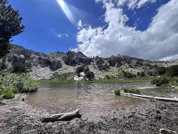
Trail Difficulty and Length
Moderate is the accurate rating. The 8.8-mile roundtrip has about 2,000 feet of elevation gain concentrated in the upper half of the hike. The lower section through the forest is a comfortable warm-up. The upper section on open rocky terrain with a steep final push to the lake rim is where the difficulty lives. Plan 4-5 hours for the round trip at a comfortable pace with time at the lake. Fit hikers move through faster. Anyone not acclimated to elevation should expect the upper section to take longer than the terrain alone suggests, since the trailhead sits around 8,800 feet and the lake is near 10,500 feet. Sturdy hiking boots are the right footwear. The lower trail is fine in trail runners, but the upper boulder sections are more comfortable and safer with ankle support and a proper sole. Trekking poles help on the steep final push and on the descent.
Dog Friendly?
Yes. Liberty Lake Trail is on National Forest land and dogs are welcome on leash. The trail terrain is varied enough that dogs need to be evaluated honestly: the lower forest section is easy for most dogs, the boulder fields on the upper section require athletic dogs to scramble, and the steep final push to the lake rim demands confidence on uneven terrain. Bring at least 1 liter of water per dog for the approach. The lake is a water source requiring treatment for humans but dogs tend to drink directly from mountain lakes without issue. Keep dogs out of the lake immediately around the inlet streams to minimize impact on the water source. Keep them leashed near the cliff edges around the lake perimeter.
What to Bring
Water is the priority. Bring at least 2-3 liters per person from Elko. A water filter or purification tablets if you want to supplement from the lake or streams on the upper section. Food for a 4-5 hour outing plus extra for lake time. Layers. The trailhead elevation is nearly 9,000 feet and the lake is close to 10,000. Morning temperatures can be in the 40s even in July. The afternoon can turn stormy fast in the Ruby Mountains, especially in July and August. A rain shell and a mid-layer are both worth carrying. Sturdy hiking boots or trail runners with grip for the boulder sections. Trekking poles. Sun protection for the exposed upper section. For photography: wide-angle for the lake and cirque, longer focal length for the cliff detail and snowfield texture. Polarizing filter for the lake reflection work in morning light. 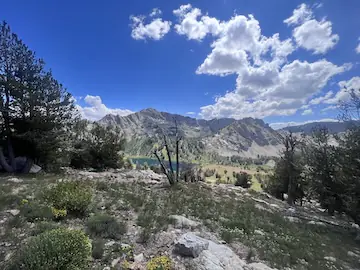
Best Time to Hike Liberty Lake Trail
Late June through September is the reliable window. Snow typically clears from the trail by late June in most years, though the upper sections can hold snow patches into July. Check trail conditions with the Humboldt-Toiyabe National Forest Ruby Mountains Ranger District before your trip if you’re going before mid-July. July and August bring wildflowers to the lower meadow sections and the lake inlet areas, afternoon thunderstorms that build quickly after noon, and the highest trail traffic of the year. Start early and plan to be off the exposed upper sections by 1 p.m. if afternoon thunderstorms are in the forecast. September is the best overall month. Temperatures are cooler, the aspens in Lamoille Canyon start turning gold by mid-month, afternoon storms become less frequent, and the crowds thin significantly. The fall color in the canyon on the drive in is legitimately stunning and worth timing a trip around. For photography, morning is the priority at any time of season. The light on the cirque walls and the lake reflection both work best in the first two hours after sunrise. Plan to be at the lake by 9-10 a.m. for the best conditions.
Rules and Regulations
No campfires in the Ruby Mountains Wilderness area and along most of the Liberty Lake Trail corridor. Pack a camp stove if you’re cooking anything. Pack out all trash and dog waste. Stay on the trail in the lower sections to protect the alpine meadow vegetation and minimize erosion on the hillsides. On the upper boulder sections, the route crosses open rock where there’s no trail to stay on; use cairns as guides and walk on rock surfaces rather than soil or vegetation. The lake is a water source. Camp at least 200 feet from the shoreline if you’re backpacking. Day hikers: respect the lake perimeter, don’t wash dishes or gear in the water, and leave the shoreline flat rocks for others to use.
Where to Stay Near Elko
Elko is your base for Liberty Lake Trail, about 30 miles and 40 minutes from the trailhead. The town has solid lodging options for a mid-sized Nevada city and serves as a natural overnight stop on the I-80 corridor. For points travelers, check available Marriott Bonvoy properties in Elko, IHG Rewards hotels near Elko, and Hilton Honors options in Elko. Elko lodging fills during the National Cowboy Poetry Gathering in January and during summer weekends when Lamoille Canyon draws outdoor visitors.
Camping Nearby
Several developed campgrounds operate in Lamoille Canyon through the Humboldt-Toiyabe National Forest. Thomas Canyon Campground is the closest developed option to the Liberty Lake trailhead, sitting partway up Lamoille Canyon Road with tent and RV sites. It typically operates from late May through September and requires reservations during peak season through recreation.gov. Dispersed camping is permitted on National Forest land in some areas around the Ruby Mountains, but not within the Wilderness boundary. Check current regulations with the Ruby Mountains Ranger District in Spring Creek, Nevada, before planning an overnight.
Nearby Adventures
Island Lake Trail shares the Liberty Lake trailhead and branches at the signed junction. It runs to a different alpine lake in the same cirque system. Running both in a single day is possible for fit hikers but makes for a long day. More commonly, visitors choose one or the other and return for the second on a separate trip. The Ruby Crest Trail is a multi-day backpacking route that traverses the crest of the Ruby Mountains for roughly 40 miles from south to north. It’s one of Nevada’s best long routes and can be accessed from the Lamoille Canyon area. Day hikers can sample the crest trail from the trailhead without committing to the full traverse. Lamoille Canyon itself has several short interpretive trails and picnic areas at lower elevations accessible to any hiker. The canyon road is a designated scenic byway and works well as an evening drive out of Elko even without a specific trail objective. In Elko: the Northeastern Nevada Museum covers local history, wildlife, and art and gives context for the region. The Western Folklife Center documents cowboy and ranching culture of the Great Basin. Both are worth an hour if you’re staying overnight in Elko. For food, Elko has a solid downtown with restaurants serving the I-80 corridor traffic and the local ranching community. The Star Hotel has been serving Elko’s Basque community since the 1900s and is the most distinctive dining option in town.
Plan This Hike
AllTrails has Liberty Lake Trail mapped with offline capability and condition reports from recent hikers. Download it before you lose signal on NV-227 south of Elko. Trail condition reports are particularly useful for timing your visit relative to snowmelt in the upper sections. Plan your hike on AllTrails and pull the offline map while you’ve still got signal in Elko.
Chase the Quiet
The Ruby Mountains exist in a category of Nevada that most people don’t know is there. You drive I-80 through Elko and the landscape is big and open and honest about being desert. Then you turn south and climb into a canyon that feels borrowed from Colorado. The Liberty Lake Trail takes you to the top of that canyon and drops you at a lake that has no reason to be as beautiful as it is given everything else Nevada has going on at that elevation. I’m glad it’s there. I’m glad I went.
Support the Adventure
To make your walls less boring, check out my photography portfolio and bring a piece of the wild and my story into your home. If you’d like to fuel future adventures, you can donate a coffee on Ko-Fi. Every cup keeps me chasing sunrises and stories. When you shop using my affiliate links, every click helps support this blog at no extra cost to you. It’s a small way to keep Unicorn Adventure alive and kicking while I keep exploring. Subscribe to my mailing list for future updates, new stories, and behind-the-scenes adventures. Stay connected with me on Instagram and Facebook for more photos and daily inspiration. Thanks for being part of the journey, Unicorn Squadron!

Theo Maynard is a landscape photographer and adventure blogger based in Salt Lake City. He chases remote desert and mountain light across the American West, documents it all solo, and shares the journey through Unicorn Adventure. He’s on the autism spectrum, and that’s not a footnote, it’s the whole story. He creates to inspire others to get outside, chase what lights them up, and live their best possible life. Unapologetically himself.