

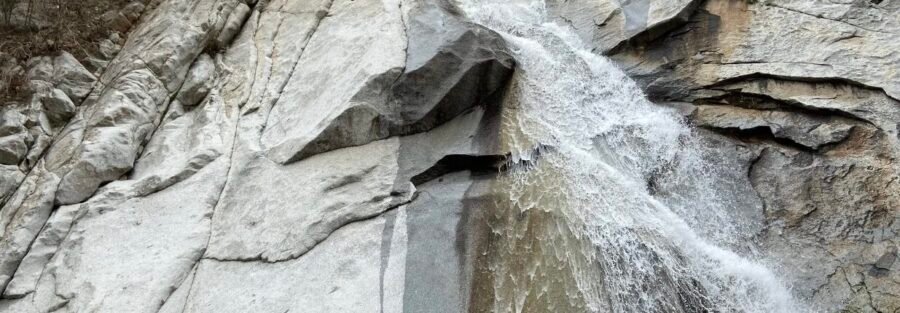
Two tenths of a mile. Seventy-five feet of gain. One waterfall cascading down a granite face in one of the most scenic canyons in the Wasatch. Lisa Falls is the kind of stop that earns its place on any Little Cottonwood Canyon day. Lisa Falls sits in the Uinta-Wasatch-Cache National Forest about 4.3 miles up Little Cottonwood Canyon Road from Sandy. The trail is short enough to be the first stop of a canyon day or the one you squeeze in on the way home. The waterfall runs strongest in spring and early summer on snowmelt, and the granite canyon walls and aspen and conifer canopy make it worth the stop even when the flow is lighter. A quiet five minutes at the base of a waterfall in a granite canyon is more useful than it sounds. Here’s everything you need to visit Lisa Falls.
Quick Facts
| Trail Name | Lisa Falls Trail |
| Location | Little Cottonwood Canyon, Uinta-Wasatch-Cache National Forest, Sandy, Utah |
| Coordinates | 40.5727, -111.7265 |
| Distance | 0.2 miles (round trip) |
| Elevation Gain | 75 feet |
| Difficulty | Easy |
| Time | 20-30 minutes |
| Dogs Allowed | No (protected watershed) |
| Fee | None |
| View on Alltrails | |
How to Get There
From Sandy, head east on 9400 South, which becomes Little Cottonwood Canyon Road (UT-210). Drive approximately 4.3 miles up the canyon. The trailhead is on the south side of the road at a small dirt pullout. It’s easy to miss at canyon speed, so watch your mileage. The pullout appears on the right as you head up-canyon, just past the road curves away from the creek.
Parking Information
The pullout holds only a handful of vehicles. On summer weekends and spring snowmelt season it fills fast, sometimes before 8 a.m. If it’s full when you arrive, continue up canyon toward the Red Pine or White Pine trailhead pullouts and walk back, or return earlier next time. No restrooms at the trailhead. Handle that at the Snowbird or Alta facilities further up canyon, or before you leave Sandy.
Cell Service and Navigation
Cell service in Little Cottonwood Canyon is spotty. It improves near the base of the canyon and degrades as you go further up. For a 0.2-mile trail with a clear destination, navigation isn’t a real concern here. The trail is obvious and the falls are audible before you see them. That said, load the coordinates before you enter the canyon in case service drops before you reach the pullout.
What to Expect on Lisa Falls Trail
The Trail
The trail begins at the pullout and heads immediately into the trees. The forest here is a mix of aspen and conifers with large granite boulders scattered through the understory. The sound of the falls reaches you early. The trail is short, mostly shaded, and climbs gently over uneven terrain. Footing is rocky in spots near the base of the falls where the ground is wet. Wear shoes with grip, not sandals.
The Falls
Lisa Falls drops down a smooth granite face into a small pool at the base. The flow is strongest in May and June on snowmelt. By late summer it’s lighter but still running. The surrounding canyon walls are dramatic, the granite is pale grey and enormous, and the whole scene is cool and shaded even on warm canyon days. This is a photography stop as much as a hike. Wide angle captures the full granite frame around the falls. A neutral density filter gives you a silky long exposure on the water. The short access makes it practical to bring a tripod without committing to a full day’s carry.
Trail Difficulty and Length
Lisa Falls is 0.2 miles round trip with 75 feet of gain. It’s rated easy and that’s accurate. Almost any fitness level can do this. The terrain near the base of the falls is uneven and wet, which demands some foot care, but there’s nothing technical or strenuous about it. Budget 20 to 30 minutes including time at the falls. It’s a natural add-on to any Little Cottonwood Canyon day without meaningfully affecting your schedule.
Dog Friendly?
No. Little Cottonwood Canyon is a protected municipal watershed. Dogs are prohibited throughout the canyon to protect water quality. No exceptions. If you want to hike with your dog in the area, Millcreek Canyon to the north is dog-friendly on odd-numbered days (leash required) and offers solid trail options without the watershed restrictions.
What to Bring
Water and a snack if you’re making it part of a longer canyon day. Trail shoes or hiking shoes with grip for the rocky, wet terrain near the base of the falls. A camera if photography is the point, which for many people it is. A tripod if you want long-exposure shots of the water. Layers in spring and fall when the canyon stays cold even when the valley is warm. That’s genuinely all you need for 0.2 miles.
Best Time to Hike Lisa Falls
Late spring through early fall is the reliable window. May and June deliver the strongest waterfall on snowmelt and the canyon is brilliant green from the recent runoff. Summer is warm in the valley but the canyon stays noticeably cooler. Fall turns the aspens gold in late September and early October, which makes the short hike genuinely spectacular for foliage photographers. The trail can be icy in winter and the pullout is not always plowed, so winter visits require checking conditions first. For photography, overcast days are excellent at Lisa Falls. Diffused light eliminates harsh shadows on the granite and renders the water and moss evenly. Early morning on a clear day gives you soft light before direct sun hits the canyon. Midday direct sun creates blown highlights on the white granite that are hard to manage. Shoot early or shoot cloudy.
Rules and Regulations
Lisa Falls is in the Uinta-Wasatch-Cache National Forest inside the Little Cottonwood Canyon watershed. No dogs, no swimming or wading in the creek, no fee. Leave No Trace applies: pack out everything, stay on the established trail, don’t alter the creek or pool at the base of the falls. The watershed protection rules are enforced. Violations can result in fines. Respect them. The canyon is the source of drinking water for a significant portion of the Salt Lake Valley.
Where to Stay Near Little Cottonwood Canyon
Sandy and Cottonwood Heights have a full range of lodging options close to the canyon mouth. Salt Lake City is 20 minutes north with significantly more inventory. For hotel points check Marriott Bonvoy, IHG Rewards, and Hilton Honors. The Snowbird and Alta lodges further up canyon are options if you’re making a multi-day ski or summer resort trip out of it.
Camping Nearby
Camping is not permitted in Little Cottonwood Canyon due to the watershed protection designation. Big Cottonwood Canyon, the next canyon north, has Redman Campground and other established sites that are reservable through recreation.gov. These fill fast in summer.
Nearby Adventures
Lisa Falls is a warm-up, not a destination by itself. Little Cottonwood Canyon has serious hiking options above it. Red Pine Lake Trail covers 7.5 miles with 2,109 feet of gain to an alpine lake ringed by Wasatch peaks. White Pine Lake Trail goes 10.7 miles with 2,716 feet of gain to one of the most scenic high-altitude lakes in the range. Both are full-day commitments. The aerial tram at Snowbird lifts you to 11,000 feet for panoramic views without the gain, and Hidden Peak at the top of the tram connects to ridge hikes in every direction. One canyon north, Big Cottonwood Canyon has Lake Blanche, one of the most stunning alpine lake hikes in Utah at 6.2 miles and 2,800 feet of gain. The Living Room Trail in the Salt Lake Foothills is a shorter accessible option with excellent valley views that works as a rest-day hike close to the city. Snowbird and Alta operate summer activities including the Snowbird tram, mountain biking, and zip lines. The scenic drive up the canyon is worth doing slowly even without a trailhead destination.
Plan This Hike
AllTrails has the Lisa Falls Trail with a map and recent user conditions. Given how short the hike is, the most useful check is the pullout parking availability from recent user comments and current water flow reports. View on Alltrails AllTrails Pro is worth it if you’re planning a full day in Little Cottonwood Canyon and want offline maps for the longer trails above Lisa Falls.
Chase the Quiet
Twenty minutes. A granite canyon, some aspen and conifer, and a waterfall. That’s the whole transaction at Lisa Falls. Most of my adventures are much longer and much harder. But a five-minute walk to a waterfall in the Wasatch that resets your head for the rest of the day is its own kind of thing. I don’t drive past it anymore without stopping. It’s too close, too easy, and too good.
Support the Adventure
To make your walls less boring, check out my photography portfolio and bring a piece of the wild and my story into your home. If you’d like to fuel future adventures, you can donate a coffee on Ko-Fi. Every cup keeps me chasing sunrises and stories. When you shop using my affiliate links, every click helps support this blog at no extra cost to you. It’s a small way to keep Unicorn Adventure alive and kicking while I keep exploring. Subscribe to my mailing list for future updates, new stories, and behind-the-scenes adventures. Stay connected with me on Instagram and Facebook for more photos and daily inspiration. Thanks for being part of the journey, Unicorn Squadron!

Theo Maynard is a landscape photographer and adventure blogger based in Salt Lake City. He chases remote desert and mountain light across the American West, documents it all solo, and shares the journey through Unicorn Adventure. He’s on the autism spectrum, and that’s not a footnote, it’s the whole story. He creates to inspire others to get outside, chase what lights them up, and live their best possible life. Unapologetically himself.