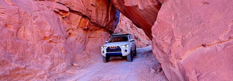
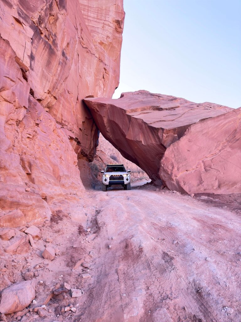
Long Canyon earns its name the right way. The canyon walls close in tight early in the route, red Wingate Sandstone rising hundreds of feet on both sides as the road threads through below, and then Pucker Pass arrives and the walls get even closer. A massive boulder has wedged itself between the canyon walls over some geologic time frame that makes human history look like a footnote, and the road goes under it. That’s the moment that gets remembered.
This guide covers the Long Canyon OHV Route from trailhead to trailhead: vehicle requirements, what the road actually does, when to go, and what else to pull into a full Moab day around it.
Quick Facts
|
Route Name |
Long Canyon OHV Route |
|
Location |
BLM Land, near Moab, Utah |
|
Coordinates |
|
|
Distance |
7.5 miles one-way (shuttle recommended); 15 miles out-and-back |
|
Elevation Gain |
Approx. 2,300 feet |
|
Difficulty |
Easy to Moderate (4WD strongly recommended at Pucker Pass) |
|
Time |
2-3 hours one-way |
|
Dogs Allowed |
Yes, on leash |
|
Fee |
None (BLM land) |
|
AllTrails |
How to Get There
From downtown Moab, head north on US-191 for about 9 miles, then turn left onto UT-313 toward Canyonlands National Park. After roughly 2 miles on UT-313, watch for the signed Long Canyon Road turnoff on the left. This dirt road marks the upper trailhead for the top-to-bottom run.
The route runs 7.5 miles one-way and exits near Moab on the lower end. Running it top-to-bottom requires a two-vehicle shuttle: leave one vehicle at the lower end near Moab before driving the other to the upper UT-313 trailhead. Alternatively, run it out-and-back from either end. Most drivers do the top-to-bottom shuttle since the upper end offers the most dramatic canyon entry and Pucker Pass comes before the midpoint.
From Salt Lake City, plan about 4 hours: I-15 south, US-6 east, US-191 south to Moab, then north on US-191 to UT-313. From Grand Junction, Colorado, roughly an hour west. No entry fee, no reservation required.
Cell Service and Navigation
Cell coverage drops as you leave US-191 and disappears inside the canyon itself. Download AllTrails or a dedicated OHV nav app offline before leaving Moab. Once you’re in the canyon walls, you’re on your own for data.
The route is straightforward on the main track with no major junctions requiring navigation decisions until you’re clear of the canyon. Having GPS tracking active is useful for knowing where you are relative to Pucker Pass and the lower terminus, especially on a first run. A paper map of the Moab BLM area trails is worth having as backup.
What to Expect on the Long Canyon OHV Route
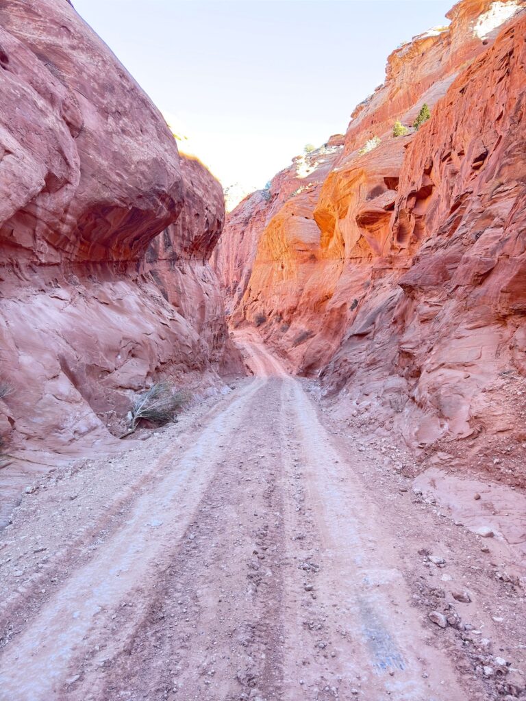
The Road
The upper section of the route enters Long Canyon quickly and the walls close in. The road surface alternates between packed dirt, loose rock, and sections of embedded sandstone that require attention. The canyon is narrow enough in places that two vehicles passing requires care and communication. Go slow in the tight spots and be prepared to back up if you meet traffic coming the other direction.
The terrain is generally manageable for any high-clearance 4WD vehicle on dry roads. The rocky sections at Pucker Pass are the exception. That specific spot demands 4WD engagement and careful line selection. Airing down to 20-25 PSI before starting improves traction and confidence through the rocky sections throughout the route.
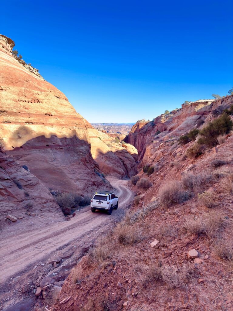
Past Pucker Pass, the canyon begins to open. The walls spread, the views extend, and the road becomes progressively more open as you drop toward the lower end. The La Sal Mountains appear to the east. The character of the drive shifts from enclosed and vertical to wide and horizontal.
Pucker Pass
Pucker Pass is the route’s defining moment. A massive boulder has fallen and wedged between the canyon walls at a height that leaves a passable gap underneath for vehicles with the right dimensions and the right approach. Tall rigs and wider vehicles need to assess before committing. Most standard 4WD trucks and SUVs fit, but knowing your vehicle’s dimensions matters here.
The name is honest. First-timers pucker. The clearance feels tight from inside the vehicle. Go slow, spot the line, and let the vehicle do its job. The rock is solid and the obstacle is well-traveled. Thousands of vehicles have made it through. Yours will too if it fits.
For photography, Pucker Pass rewards wide-angle from the approach and a longer focal length to show the boulder wedge from the front. The canyon walls frame the boulder against the sky in a way that’s genuinely striking. Stop before you commit to the pass and get your shots, since the scramble through doesn’t allow for lingering.
Drive Difficulty and Length
Easy to moderate is accurate for the canyon route in dry conditions, with the moderate rating coming specifically from Pucker Pass rather than the overall terrain. The 7.5-mile one-way distance covers mixed terrain across about 2,300 feet of elevation change. Budget 2-3 hours one-way at a comfortable pace with stops for photography and the Pucker Pass moment.
The route is fundamentally not appropriate for vehicles without 4WD. AWD crossovers with low clearance have gotten stuck at Pucker Pass and in the rocky canyon sections. High-clearance 4WD with the ability to engage low-range is the right tool. That’s not a suggestion.
Wet conditions change everything. The clay and sand surfaces in Long Canyon become deeply slick in rain and can strand vehicles even with 4WD. Check the full upstream weather forecast before committing, and wait a day after any rain before running the route.
Dog Friendly?
Yes. Long Canyon is BLM land and dogs are welcome with a leash. The route offers enough pullout space to get out with your dog and let them explore at several points along the canyon. The open sections past Pucker Pass are the best spots for a leg stretch.
Keep dogs away from the canyon edges in the narrower sections, the drop-offs are real and some spots don’t have obvious visual warnings before the edge. Bring water. The canyon walls trap heat and dogs dehydrate faster than they show it. Plan water breaks every 30-45 minutes in warm weather.
What to Bring
For the vehicle: a full-size spare, a tow strap, and a portable air compressor. Airing down to 20-25 PSI before the canyon improves traction and ride quality. Know your vehicle’s height and width before approaching Pucker Pass. A hi-lift jack and recovery boards add useful options if things go sideways in the rocky sections.
For you and passengers: water, minimum 2-3 liters per person plus dog water. Sun protection for the open sections. Snacks with salt for electrolyte replacement on hot days. The canyon walls provide shade in the tight sections but the open terrain above the pass is fully exposed.
For photography: wide-angle for the canyon walls and Pucker Pass approach, mid-range for the La Sal Mountains views from the upper sections, longer focal length for the boulder wedge at Pucker Pass. Morning light coming over the east walls into the canyon is the best window for shooting the lower sections.
Best Time to Drive Long Canyon
Spring and fall are the reliable windows: March through May and September through November. Canyon temperatures are comfortable, the road is dry, and the light on the red walls has warmth without the overhead brutality of summer.
Summer driving in the canyon is possible with a very early start, before 7 a.m. The canyon walls trap heat by midday and the exposed upper sections compound it. Summer morning light on the red rock is beautiful, but you need to be moving by first light to catch it before the heat arrives.
Winter brings cold and the possibility of ice at Pucker Pass and on the shadowed canyon floor. Check conditions with the Moab BLM Field Office. Snow on the upper sections near UT-313 can make the entry impassable. The canyon in winter light is striking, but it needs careful timing.
Morning is the better photography window throughout the route. The canyon walls face east on the lower approach and catch direct morning light that turns the sandstone from orange to copper in the first hour after sunrise. Plan to enter from the upper trailhead at or just after sunrise to follow the light down the canyon as it develops.
Rules and Regulations
Stay on the designated route. The BLM terrain around Long Canyon has cryptobiotic soil crust that doesn’t recover from off-route driving. Do not create new tracks around obstacles. If an obstacle feels wrong for your vehicle, turn around.
Pack out all trash. Dogs on leash. No fires without a fire pan and current restrictions allowing. Check fire restrictions with the Moab BLM Field Office seasonally. Flash flood risk in slot canyon terrain is real. A storm far upstream of Long Canyon can send water through faster than you can react. Check the full watershed forecast before entering.
Be courteous to oncoming traffic in the narrow sections. The canyon is tight enough in places that communication between drivers matters. Give way when you have the better position to back up.
Where to Stay Near Moab
Moab is the base. The lower end of the Long Canyon route exits near town, which makes logistics simple. The town has lodging at every price point. Red Cliffs Lodge on the Colorado River on Highway 128 and The Caves at Moab are two options with more character than standard chain rooms. For points travelers, check available Marriott Bonvoy properties in Moab, IHG Rewards hotels near Moab, and Hilton Honors options in the area. Book well ahead for spring and fall.
Camping Nearby
BLM dispersed camping is available near the Long Canyon route and throughout the BLM land northwest of Moab. The Gemini Bridges area is the most established dispersed camping zone in this part of the BLM corridor. Standard rules apply: pack in, pack out, 14-day stay limit, no fires without a fire pan and current restrictions allowing.
The Sandflats Recreation Area east of Moab has both dispersed and fee sites with facilities and is the most organized camping option for OHV-based Moab trips. Porcupine Rim is the other main dispersed option for overlanders.
Nearby Adventures
Gemini Bridges is the natural companion run. It runs through similar BLM terrain northwest of Moab, covers 13 miles one-way, and ends at two massive parallel sandstone arches. It’s a different character from Long Canyon, more open terrain versus tight canyon walls, but shares the same BLM access corridor and pairs well as a two-day combination.
Onion Creek is another Moab OHV route, running through a canyon with repeated stream crossings and red and white banded walls. Worth adding to a multi-day Moab OHV itinerary as a distinctly different terrain type from Long Canyon.
For hikers in your group, Corona Arch Trail is the best dog-friendly arch hike near Moab and accessible from Potash Road about 10 miles west of town. Delicate Arch inside Arches National Park is the marquee hiking experience in the area.
Plan This Drive
AllTrails has Long Canyon OHV Route mapped with offline GPS tracking. The Pucker Pass section in particular benefits from active GPS to confirm your position relative to the obstacle. Plan your drive on AllTrails and pull the offline map in Moab before heading out.
Chase the Quiet
Pucker Pass is the kind of obstacle that earns its name on the approach and gets remembered for years. A boulder wedged between canyon walls, the road threading underneath, your truck inches from the rock on both sides as you pick your line through. That’s the moment. The rest of Long Canyon is the canyon walls, the La Sal Mountain views, and the slow drop from the mesa to the lower terminus. But the pass is what brings people back. Drive it once and you understand why.
Support the Adventure
To make your walls less boring, check out my photography portfolio and bring a piece of the wild and my story into your home.
If you’d like to fuel future adventures, you can donate a coffee on Ko-Fi. Every cup keeps me chasing sunrises and stories.
When you shop using my affiliate links, every click helps support this blog at no extra cost to you. It’s a small way to keep Unicorn Adventure alive and kicking while I keep exploring.
Subscribe to my mailing list for future updates, new stories, and behind-the-scenes adventures.
Stay connected with me on Instagram and Facebook for more photos and daily inspiration.
Thanks for being part of the journey, Unicorn Squadron!

Theo Maynard is a landscape photographer and adventure blogger based in Salt Lake City. He chases remote desert and mountain light across the American West, documents it all solo, and shares the journey through Unicorn Adventure. He’s on the autism spectrum, and that’s not a footnote, it’s the whole story. He creates to inspire others to get outside, chase what lights them up, and live their best possible life. Unapologetically himself.