The brain never really shuts up. But 126 feet of water hitting a canyon pool? That quiets things down pretty fast.
Lower Calf Creek Falls sits inside Grand Staircase-Escalante National Monument, about 15 miles east of the town of Escalante on Highway 12. It’s one of the most rewarding hikes in southern Utah, and not just because the payoff is a wall of falling water in the middle of the desert. The canyon itself earns it. Cottonwoods and willows crowd the creek. Fremont petroglyphs mark the canyon walls. Sandstone towers overhead in every direction.
This is your complete guide to hiking Lower Calf Creek Falls.
Quick Facts
| Trail Name | Lower Calf Creek Falls |
| Location | Grand Staircase-Escalante NM, near Escalante, Utah |
| Coordinates | 37.7948° N, 111.4131° W |
| Distance | 6.1 miles (round trip) |
| Elevation Gain | 531 feet |
| Difficulty | Moderate |
| Time | 3-4 hours |
| Dogs Allowed | Yes (on leash) |
| Fee | $5/vehicle (America the Beautiful Pass accepted) |
| AllTrails | View on Alltrails |
How to Get There
From Escalante, head east on Utah Highway 12 for approximately 15 miles. The Calf Creek Recreation Area is well-signed from the highway. Coming from Boulder to the east, head west on Highway 12 for about 11 miles. The road is paved the whole way, and the drive through the canyon is one of the most scenic stretches of pavement in Utah, so don’t rush it.
Parking Information
The Calf Creek Recreation Area has a paved parking lot at the trailhead. It fills fast on weekends and during spring and fall peak season. Arriving before 8 a.m. is the move. Overflow parking lines the highway shoulder. The lot has restrooms and picnic tables. There’s also a campground here if you want to wake up already at the trailhead.
Cell Service and Navigation
Cell service along Highway 12 is spotty and basically nonexistent inside the canyon. Don’t count on it. Download offline maps before you leave, either through AllTrails or Google Maps. The trailhead and route are clearly marked, so navigation isn’t complicated, but you’ll want something to track your progress. GPS units work fine down here. Your carrier will not.

What to Expect on Lower Calf Creek Falls
The Trail
The trail follows Calf Creek almost the entire way. It’s mostly flat with some sandy sections, and the creek keeps things from feeling like a slog. The path is well-marked, and interpretive signs along the route give you context about the canyon’s natural and cultural history. You’re hiking through a slot-like canyon with towering sandstone walls, which means shade in the morning and gold light in the late afternoon. Watch for Fremont petroglyphs on the canyon walls. They’re easy to miss if you’re moving fast, so slow down.
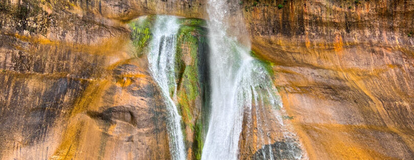
The falls drop 126 feet into a clear, cold pool at the end of the canyon. It’s legitimately stunning. The pool is surrounded by lush vegetation, ferns, and greenery that feels completely out of place in the surrounding desert. You can wade in. Most people do. The spray and the shade make it a perfect spot to sit and eat lunch before heading back.
Trail Difficulty and Length
The trail is 6.1 miles round trip with 531 feet of elevation gain. It’s rated moderate, and that’s accurate. The terrain is mostly flat with some sandy sections that slow you down. It’s not a technical trail. Most reasonably fit hikers will complete it in 3 to 4 hours. The sandy stretches can fatigue your legs more than you’d expect, so don’t underestimate it if you’re bringing kids or dogs.

Dog Friendly?
Yes, dogs are welcome on this trail and must be on a leash. The creek gives them plenty of chances to cool off and drink along the way. Be smart about summer heat. Desert temperatures can spike well above 100 degrees, and the sandy terrain holds heat. Bring more water than you think you’ll need for both of you. Booties are worth considering in peak summer.
What to Bring
Water is the priority, at least 2 to 3 liters per person. The hike is mostly exposed in stretches, and the desert will drain you faster than you expect. Sunscreen, a hat, and sunglasses are non-negotiable. Bring snacks for the waterfall because you’ll want to stay a while. Good trail runners or hiking shoes with traction handle the sandy terrain better than casual sneakers. Trekking poles aren’t necessary but help on the return when your legs are tired. A camera or tripod is worth packing if you care about getting the falls right.

Best Time to Hike Lower Calf Creek Falls
Spring (April through June) and fall (September through October) are the sweet spots. Temperatures are comfortable, the creek is running well, and the canyon light is gorgeous. Summer works but demands an early start. By 10 a.m. the heat is serious. Winter is doable with the right gear, though ice can form in shaded sections of the trail.
For photography, the best light hits the waterfall in the mid to late morning as the sun clears the canyon walls. Golden hour at the end of the day wraps the canyon in warm light on the hike out. The pool at the base of the falls photographs best with a neutral density filter and a long exposure to smooth the water.
Rules and Regulations
Lower Calf Creek Falls is managed by the BLM as part of Grand Staircase-Escalante National Monument. A $5 day-use fee is charged per vehicle at the Calf Creek Recreation Area. The America the Beautiful Annual Pass covers entry. Leave No Trace principles apply: pack out everything, stay on the designated trail, and don’t disturb petroglyphs or archaeological features. Pets must be leashed at all times. Swimming is permitted at the falls pool.

Where to Stay Near Escalante
The town of Escalante has limited but solid lodging options. Boulder, about 30 minutes east on Highway 12, is worth considering if you’re exploring multiple trailheads in the area.
Camping Nearby
The Calf Creek Recreation Area campground sits right at the trailhead. It’s small, with 13 sites, and fills fast especially on weekends from spring through fall. Reserve early through Recreation.gov.
For dispersed camping, the BLM land throughout Grand Staircase-Escalante offers several spots. Cedar Point, South Turkey, and Spencer Flat are all in the area, primitive BLM sites with minimal facilities and maximum sky. No hookups, no reservations, no crowds.
Nearby Adventures
Grand Staircase-Escalante is loaded with trails worth adding to your list. Escalante Natural Bridge is a short out-and-back at 4.4 miles and 291 feet of gain that drops you in front of a stunning natural arch. Zebra and Tunnel Slot Canyons, accessible from Hole-in-the-Rock Road, cover 6.6 miles with 469 feet of gain through some of the narrowest passages in the monument. Devils Garden is a quick 0.4-mile loop through hoodoos and arches worth stopping for, especially if you’re camping in the area.
If you’re driving rather than hiking, the Burr Trail and Moki Dugway are two of the most dramatic roads in Utah and both deserve their own days.
Off the trail, the Anasazi State Park Museum in Boulder is a legitimate stop. It covers the history of the ancient Puebloan people who lived in this area and has actual artifacts and a reconstructed village on site. The Escalante Petrified Forest State Park, a few miles west of town, showcases fossilized wood in a colorful badlands landscape and makes an easy add-on.
Plan This Hike
AllTrails has the full route for Lower Calf Creek Falls with trail maps, user reviews, and recent conditions from other hikers. Download the map before you leave cell service. It’s the most reliable way to stay oriented in the canyon.
View on Alltrails.
AllTrails Pro is worth considering for Grand Staircase trips where connectivity is unreliable. Offline maps, turn-by-turn navigation, and trail vetting from actual hikers make it a solid investment for desert hiking.
Chase the Quiet
There’s something about standing at the bottom of a 126-foot waterfall in the middle of the desert that rewires your brain chemistry. The drive through the monument doesn’t prepare you for it. The trail doesn’t prepare you for it. You round the last bend, and it’s just there, dropping into a pool of impossibly clear water surrounded by green. In a landscape that’s all red and tan and dust, it hits different.
Support the Adventure
To make your walls less boring, check out my photography portfolio and bring a piece of the wild and my story into your home.
If you’d like to fuel future adventures, you can donate a coffee on Ko-Fi. Every cup keeps me chasing sunrises and stories.
When you shop using my affiliate links, every click helps support this blog at no extra cost to you. It’s a small way to keep Unicorn Adventure alive and kicking while I keep exploring.
Subscribe to my mailing list for future updates, new stories, and behind-the-scenes adventures.
Stay connected with me on Instagram and Facebook for more photos and daily inspiration.
Thanks for being part of the journey, Unicorn Squadron!

Theo Maynard is a landscape photographer and adventure blogger based in Salt Lake City. He chases remote desert and mountain light across the American West, documents it all solo, and shares the journey through Unicorn Adventure. He’s on the autism spectrum, and that’s not a footnote, it’s the whole story. He creates to inspire others to get outside, chase what lights them up, and live their best possible life. Unapologetically himself.